
You must be logged in to view this content. Click Here to become a member of IndyWX.com for full access. Already a member of IndyWx.com All-Access? Log-in here.
Category: Forecast Models
Permanent link to this article: https://indywx.com/video-accumulating-snow-tuesday/
Dec 06
Would You Rather Be In The Game Fighting To Win, Or Sitting On The Bench?
The pattern over the upcoming 10-15 days presents a whole slew of challenges, but has the potential to be one winter enthusiasts remember for a long time. Arctic air is beginning to press and will eventually overwhelm the pattern by the end of the week. Additionally, a second and third surge of arctic air will be inbound next week. Each arctic plunge may become more severe as we go, especially if we can get a snowpack down. The potential is on the table for sub-zero temperatures (not even counting wind chills) by mid-month. That, my friends, is not normal for December, and is in stark contrast from Decembers of recent memory. Whether or not we get one “big ticket” event, or deal with a parade of storms that lay snow down is up for debate and will require burning the midnight oil in the good ole weather office as we progress through the next couple weeks.
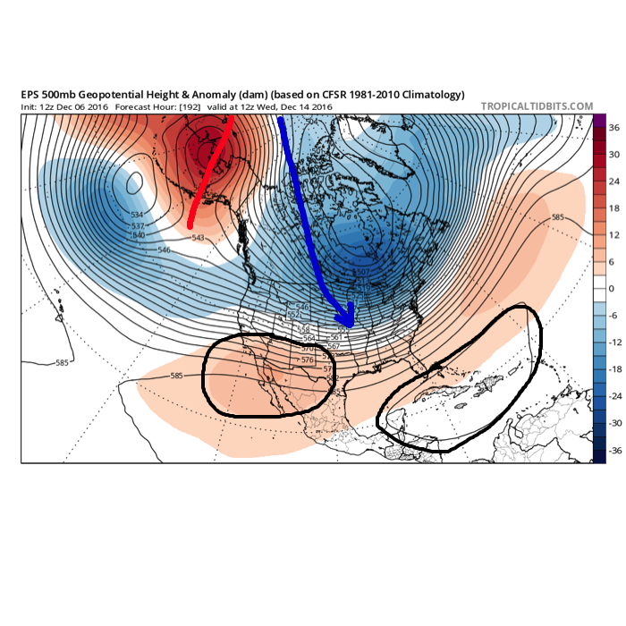 The overall set-up is certainly an intriguing one. Cross-polar flow seeds pressing arctic air into the pattern (again, it comes in “waves” over the next couple weeks, each subsequently stronger). What’s of particular interest is the battle that develops between a tag-team of ridges- SW and SE (at times these will put up more resistance than the other). Long-time Hoosiers know that when cross-polar flow gets involved it can “suppress” storms, but rest easy in knowing that the SE ridge will provide resistance. In fact, some across the lower Ohio and TN Valleys may eventually complain that the southeast ridge is providing too much resistance.
As confident as we are in the overall dramatic flip in the pattern to one capable of producing severe winter weather over the next couple weeks, per usual, the devil is in the details. Expect a tight gradient between areas where heavy snow begins to stack up and little to nothing- at least initially. Additionally, depending how things evolve, icing events may eventually require attention for portions of the lower Ohio Valley and TN Valley as that shallow arctic air “oozes” south over what may become quite the impressive snowpack north. This will require further attention in week 2.
At the end of the day, there will be “haves” and “have nots” when it comes to storms (always are) and each will require our attention and fine tuning. However, if you’re a lover of winter weather, it’s hard not to sit back and smile at what’s in front of us over the upcoming couple weeks, especially compared to the past couple Decembers.
Needless to say, we’re on the field and in the game…
Permanent link to this article: https://indywx.com/would-you-rather-be-in-the-game-fighting-to-win-or-sitting-on-the-bench/
Dec 05
Monday Morning Rambles…
1.) Rain builds back in late tonight and Tuesday morning and will favor the southern and eastern half of the state. Drier trends develop Tuesday afternoon as the moisture pulls northeast.
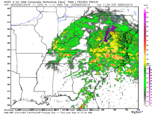
Forecast radar 11a Tuesday
2.) A surge of arctic air will pour into the region as we wrap up the work week, including single digit wind chills. Lows in the 10s and highs in the 20s can be expected Thursday and Friday.
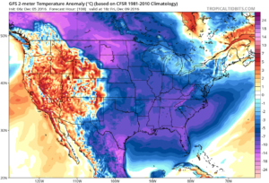
Forecast temperature anomalies to close the work week.
3.) Despite the cold, snow chances look unimpressive, per the latest data. While we, personally, still believe there will be more of an arctic wave to deal with along the arctic boundary pressing Wednesday night into Thursday (enough to accumulate), modeling says “we’re crazy” and brings the arctic plunge in without much fanfare (flurries).
4.) Speaking of snow, modeling also says the 3rd wintry threat we spoke of Sunday (for about a week from now) arrives with a warm-up and is more of a liquid event. While we tend to think this is still a threat that could deal our region wintry conditions, it would be irresponsible of us not to convey the lower confidence (heck, modeling suggests we’re close to 60 degrees next Monday).
5.) Our thoughts on a snowy December began last summer as research began on the upcoming winter. It’s based off a variety of solutions, but leans heavily on the idea blocking would develop and help “lock in” an active pattern with just enough cold air to create the wintry “goods.” (Pressing cold and an active jet undercutting the cold to create winter storm potential). While bullish on snow (still are), we’ve never had out a very cold December forecast (instead only “slightly,” or 1 degree, below average). If the recent weekend trend is correct, it says the upcoming (10) day period we thought would essentially deliver a month’s worth of snow is incorrect. Sure that gives us the second half of the month to still make up for it, but it becomes increasingly difficult to see the wild model swings and inconsistency without relaying those inconsistencies to you, the viewer.
Our overall thinking remains (as stubborn as it may seem) on December, but please know we also see how this could bust. There’s a fine line between communicating both ideas to you. Confidence is lower than we would like it to be…
Permanent link to this article: https://indywx.com/monday-morning-rambles-2/
Dec 04
Active Wintry Pattern Is Here…
If you’re a fan of cold weather, including being on the field to “cash-in” on multiple winter storm threats, this is a pattern for you. In all honesty, it’s tough to ask for a better pattern to yield such things. With that said, each respected storm threat will have its’ own set of challenges that will have to be dealt with. While we’re confident on IND being above normal in the snow department for the month of December by the 20th, it’s impossible to put numbers (from an accumulation perspective) on specific storm systems from this distance. With that said, please know that the pattern is one that will have multiple impactful winter events lining up behind one another and it’ll be important to keep updated with forecasts as we progress through the next few weeks. Needless to say, there will be plenty of opportunities to get those favorite photos with Christmas lights/ decor in the snow this season!
We’re tracking (3) winter systems over the upcoming week:
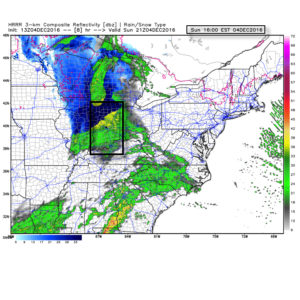
1.) Today: Dry air initially made it difficult for precipitation to make it to the surface this morning. Heavier precipitation rates will arrive after lunch and fall for a few hours (between 1p-6p for most of central IN). This will fall as mostly a cold rain from Indy and points south. Further north, including north-central IN, this will fall as a rain-snow mix (snow should become the predominant form of precipitation shortly after starting. Across northern portions of the state, this will be mostly snow and we note modeling trending colder with recent runs. With heavier snowfall rates this afternoon/ evening, travel may become dicey across northern IN and wet snow accumulations of 2″-4″. A coating to less than 1″ of snow is possible as far south as the northern suburbs of Indy. The following time stamps can give you an idea what the radar may look like this afternoon into the evening hours.
1p forecast radar
4p forecast radar
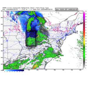
6p forecast radar
Temperatures tonight will fall below freezing for most (upper 20s to around 30) and with the lingering moisture on area roadways and sidewalks, a couple slick spots could develop here and there so be mindful. We don’t anticipate major issues, however.
2.) Wednesday night-Thursday: An arctic front will blow into town mid week and we remain bullish on the idea a wave of low pressure delivers a shot of accumulating snow as the arctic plunge moves in. As we’ve relayed over the past few days, model data is far from being in agreement on this idea, but when one looks at the overall pattern, it’s easy to see how there should be more reflection of low pressure moving along the pressing arctic boundary. These can be tricky and many times modeling is “forced” to play catch-up at last minute. For now, we continue with the idea of accumulating snow across central IN in the Wednesday night-Thursday time frame ahead of the coldest air so far this season. Temperatures will fall to between 10-15 degrees for lows by late week, including single digit ‘chills.
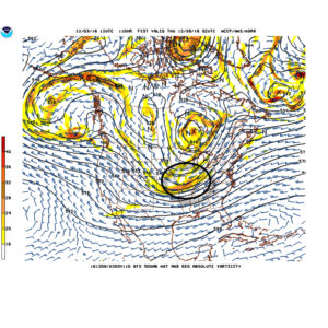
Arctic waves can be tricky in the medium range and must be watched closely.
3.) Saturday-Sunday: Our next wintry threat appears to roll into town next weekend. Similar to mid week, this, too, could be an accumulating event. It’s far too soon to get specific on timing, snowfall amounts, etc., but just know we’re keeping a close eye on next weekend for potentially more of a widespread wintry event and will sure-up details as we progress deeper into the week.
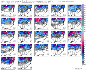
GFS ensemble members show the snowy pattern ahead over the upcoming week.
Permanent link to this article: https://indywx.com/active-wintry-pattern-is-here/
Dec 02
VIDEO: A Cold, Wintry Pattern Is Upon Us…
You must be logged in to view this content. Click Here to become a member of IndyWX.com for full access. Already a member of IndyWx.com All-Access? Log-in here.
Permanent link to this article: https://indywx.com/video-a-cold-wintry-pattern-is-upon-us/