02.13.21 Weather Bulletin: Snowfall Forecast Issued; Initial HVY Snow Zone Idea For Midweek…
Updated 02.13.21 @ 9:56a

Back-to-Back Winter Storms…A weak trough of low pressure extends south into the northern portion of Indiana this morning. This will serve to help enhance snow “up north” through the day- including a little lake enhancement this evening. Scattered snow showers will work into central Indiana later this afternoon into the evening, but shouldn’t be a big deal.
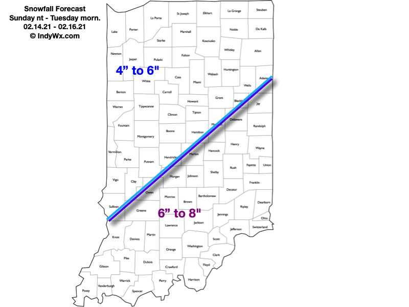
Bitterly cold air will greet us out the door Sunday morning, but this will be the proverbial calm before the storm. A mix of clouds and sun will give way to an increasingly cloudy sky during the evening hours and snow will break out from southwest to northeast late Sunday evening into the overnight and predawn Monday. This is the “1st wave” of the early week storm. A lull in the snow is possible late Monday morning into the early afternoon before the real show begins Monday evening into the predawn hours Tuesday across southeast Indiana. This will be a very cold storm and snowfall ratios will be much higher than standard 10:1 (closer to 15-20:1) which means this should be an efficient snow producer across the region. The dry, powdery nature of the snow will blow about quite easily and snow removal clients should prepare for an extended period of significant blowing and drifting issues through the upcoming week (even well after the falling snow stops).
Here’s our first stab at accumulation with Storm #1. We’ll refine these numbers if need be moving forward.
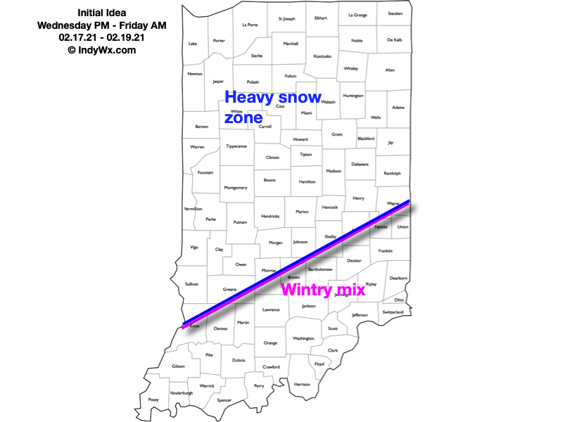
Morning snow will end from west to east Tuesday morning and we’ll have about 24 hours of relative calm before additional fun and games roll into town Wednesday night. While still early, there seems to be potential for Storm #2 to be more significant across a larger chunk of the state. We’re noticing the majority of forecast models starting to “bulk up” on precipitation amounts with this storm and the negative PNA will likely continue to force the storm ever so much further west with time. The potential is even present for more mixing issues as warmer air aloft is drawn in across southeast Indiana. Where things remain mostly (if not all) snow, a big hit is likely Wednesday evening into Friday morning. Let’s get through the day tomorrow before getting specific with totals, but here’s our initial idea.