Monday Forecast: Snow Develops By Evening

Updated 11.11.13 @ 8:30a

Zionsville, IN Despite some wind (top wind gusts this weekend reached around 30 MPH) and a chilly Sunday, the weekend was a beautiful one, complete with lots-o-sunshine!  A more active time of things is ahead to kick off the work week.  We discuss below…

Status-weather-snow-scattered-day-iconMonday: Increasing cloudiness with PM rain showers transitioning to light snow (0.50″); 28/ 46

The day will dawn with some sunshine, but clouds will be on the increase and showers won’t be far behind. This is all part of the early season arctic cold front we’ve been talking about.  We think showers (initially rain) arrive into north-central Indiana as early as the early to mid afternoon hours before pushing fairly rapidly south. It’s towards late afternoon/ early evening rain begins to transition to snow. Light snow will continue into the nighttime hours and potentially accumulate to around half an inch across most of central Indiana.

There are a couple of items we’ll have to monitor closely through the overnight and that’s the exact placement of what should be some impressive bands of lake effect snow streaming off Lake Michigan.  While the more significant accumulations, upwards of half a foot for the Indiana snow belt, will remain well north of us, there is the chance a more concentrated band of snow could reach as far south to impact portions of north-central Indiana late Monday night into Tuesday morning and result in accumulations of an inch or two for localized communities. Again, this will have to be handled as a “NowCast” scenario and isn’t set in stone.  If locally heavier snow accumulations do develop with the localized lake enhancement, the majority of this would be north of our immediate coverage area.

Temperatures will plummet Monday night into the lower to middle 20s on a gusty northwest wind.  Needless to say, slick spots could develop on area roadways Monday night.

Status-weather-snow-scattered-day-iconTuesday: Scattered AM snow showers (localized 0.50″); 22/ 35

We’ll keep an eye to area radars Tuesday, particularly in the morning hours as scattered snow showers (potential lake enhanced snow for localized spots) continue.  Conditions will be much more like winter than fall so plan to bundle up. In fact, temperatures will average close to 20 degrees below average for afternoon highs. Any lingering snow showers or flurries will begin to dissipate during the afternoon, paving way for a clear and very cold Tuesday night.

Status-weather-clear-iconWednesday: Sunny; 19/ 42

High pressure will be overhead Wednesday and help supply a day filled with sunshine, although it’ll remain MUCH colder than normal.  We’ll awake to the upper teens followed by highs reaching the lower 40s Wednesday afternoon.

Status-weather-clouds-iconThursday: Partly cloudy; 28/ 49

Temperatures will begin to moderate slowly Thursday as high pressure moves to our east. This will set the stage for a return southwesterly air flow and corresponding milder regime, albeit slowly.  After yet another cold and frosty night, temperatures will make a run at 50 degrees Thursday afternoon.

imagesFriday: Mostly cloudy; 35/ 49

A weak weather system will scoot through the region Friday and lead to an increase in cloud cover. Thinking, at least for now, has the area trying to recover from the cold, dry air mass in place so any sort of precipitation will, most likely, be tough to come by. That said, we’ll continue to monitor to see if we need to introduce a scattered light shower into our Friday forecast.

Status-weather-showers-scattered-iconSaturday: Cloudy with developing light rain; (0.25″) 39/ 52

The early look at next weekend places the region under a southerly flow of air with moisture making a return north, potentially out ahead of a rather significant storm system we’ll have to deal with early next week. The end result will initially be a rather cloudy, gloomy time of things, including developing light rain Saturday.

Video Update On Snow Accumulation & The Cold

Here’s a quick video update taking a look more closely at the forecast data for accumulating snow ahead Monday evening, as well as the impressive early season shot of cold…

You must be logged in to view this content. Click Here to become a member of IndyWX.com for full access.  Already a member of IndyWx.com All-Access?  Log-in here.

Thursday Forecast: Eyeing Snow Next Week?

Updated 11.06.13 @ 10:26p Zionsville, IN For the most part, rainfall totals today have been under what model guidance suggested.  For an area still wetter than normal, that’s not a…

You must be logged in to view this content. Click Here to become a member of IndyWX.com for full access.  Already a member of IndyWx.com All-Access?  Log-in here.

Two Totally Different Solutions For Next Week!

I wanted to quickly post on two totally different scenarios for next week.  Two of the more powerful forecast models we use to look into the mid-long range are in separate worlds when it comes to the weather pattern the middle to latter part of next week.

Here’s a look at the GFS upper air pattern:

gfs_z500_sig_east_38

Note the eastern ridging which would lead to well above normal temperatures during the middle to latter part of next week (by as much as 10 degrees above average), along with dry conditions.

HOWEVER, here’s a look at the European’s forecast upper air pattern late next week:

ecm_z500_anom_east_11

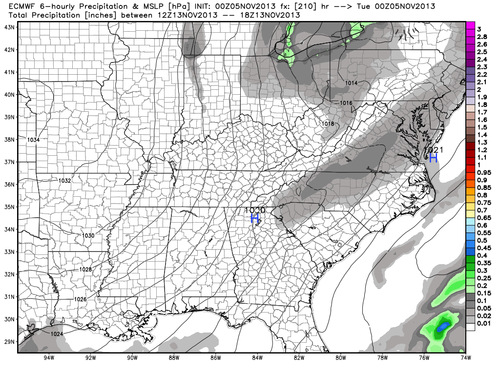
This would certainly be quite the significant storm for the Northeast, but the implications here are vastly different from that which the GFS shows above.  Instead of warmth and dry conditions, we’d deal with highs in the middle 30s and overnight lows in the lower to middle 20s.  Additionally, we’d also “enjoy” (okay, some folks would “enjoy”) snow showers and snow squalls the middle to latter portion of next week, as noted per the European below, including a lake Michigan connection.

ecmwf_slp_precip_ky_36


Needless to say, we have a lot to sort out in the coming days.  We’ll be here to do just that.  Make it a great Tuesday!

Thoughts On Winter…

This is the first time since 2002 that I haven’t produced a winter outlook.  Part of the reason behind this is due to the fact that our recent move back from Cleveland, OH to Indianapolis has taken priority.  Moving is always a much bigger chore than you expect originally.  That said, the upcoming winter of 2013-2014 presents quite the challenge when trying to determine what particular player takes control for the “long haul.”  I can’t remember a time when so many variables were at play, presenting quite the headache in trying to determine which one will take the lead.  Ultimately, confidence is lower than normal for the winter forecast.  That said, “confidence” in something 3-4 months out is never considered high. 🙂

Here are just a few items I’m looking at for the upcoming winter:

1. Data is pointing towards a southeast ridge in play for the better part of the upcoming winter.

The strength and precise position of the ridge will go a long way in aiding our weather here in central Indiana.  Southeast ridging isn’t always a bad thing in the winter if you’re a cold and snow fan as storms can’t “escape” harmlessly to our south or east.  That said, should we deal with a strong southeast ridge then we’re looking at a warmer, rainier time of things here as opposed to cold and snowy…

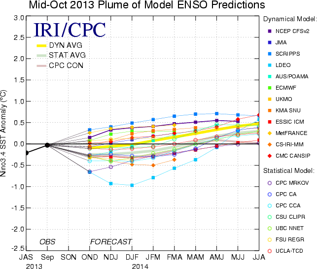
2. Modeling suggesting Nino Region 3.4 warms slightly as we progress through the winter months.

SST_table


The implications here are interesting when we drill down to the “home front.”  The following data from similar conditions during December-February in Nino Region 3.4 correlate to a few years that will go down in Hoosier snow lovers dreams…

Courtesy: http://www.cpc.ncep.noaa.gov/products/analysis_monitoring/ensostuff/ensoyears.shtml
  • 1977-1978: 49.7″ of snow, 2nd snowiest winter on record; Nino Region 3.4: +0.8
  • 2002-2003: 46.9″ of snow, 4th snowiest winter on record; Nino Region 3.4: +1.2
  • 2009-2010: 32.2″ of snow, 10th snowiest winter on record; Nino Region 3.4: +1.6

3. NAO showing signs of going negative when it matters most?

Labeled as the new “NAO Model everyone is looking for” may, perhaps, be just that.  This formula has already proven to be incredibly accurate in the past.  This was developed by fellow midwestern, Al Marinaro (you can follow him on Twitter at @wxmidwest).  In the past I’ve been one to say it’s incredibly difficult to forecast the NAO beyond 2-3 weeks, but we look at water temperatures this time of year to try and get an idea of what may happen in the coming winter months ahead.  If Mr. Marinaro is on to something (and it appears that he is) that longstanding idea will all change.

Additionally, to the delight of many cold and snow lovers out there, Mr. Marinaro’s formula suggests we’re heading for a predominantly negative NAO this winter.

BXihwRqCIAAtd3d.png-large


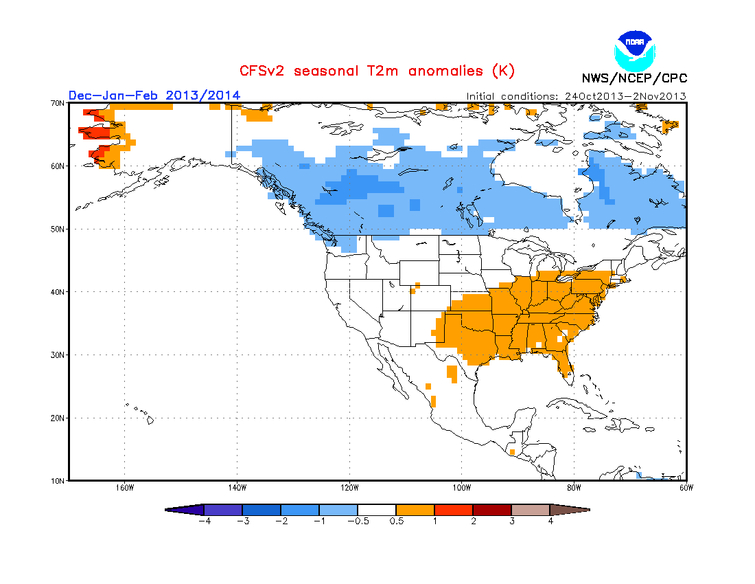
4. The normally “highly variable” CFSv2 (Climate Forecast System) monthly run has remained consistent as of late in thinking the east is warmer than normal for meteorological winter.  

It’s amazing how often this model is shown when forecasting cold, but seemingly forgotten when it’s forecasting warmer than normal conditions.

usT2mSeaInd2