Valentine’s Day Snow

Fri.

Sat.

Sun.

Mon.

Tue.

Wed.

Thr.

 Status-weather-snow-scattered-day-icon

 Status-weather-snow-scattered-day-icon

 Status-weather-clouds-icon

 Status-weather-showers-scattered-icon

 Status-weather-clouds-icon

 Status-weather-clouds-icon

 Status-weather-storm-night-icon

19/ 27

6/ 26

14/ 30

23/ 40

22/ 43

32/ 50

38/ 62 

2-5″

1″

0.00”

0.40″

0.00″

0.00″

0.50″

Forecast Updated 02.14.14 @ 11:00a

Accumulating Valentine’s Day Snow…The Canadian led the charge and other modeling has followed suit.  The region will deal with accumulating snow Valentines Day as low pressure moves southeast out of Missouri into the Tennessee Valley.  We think snow will fall at a good clip, periodically heavy, and begin around mid morning around the city.  In fact, a strip of 2-5″ of snow is likely to be laid down between Indianapolis and Louisville later today.  Latest radar trends from upstream and banding features suggest snowfall amounts may reach 6″ along the I-70 corridor. Needless to say, if you have travel plans this afternoon plan for snow covered roads and slick travel.

A fresh shot of arctic air will drill south into the region tonight and result in Saturday “wake up” temperatures in the single digits with a biting northwest wind.

Another Fast Moving Clipper…After a mostly dry Saturday, we forecast light snow to build back into the region Saturday night into early Sunday.  This will only be a light snow event and most amounts will be in the dusting to 1″ category.  The sun should quickly return Sunday afternoon, though it’ll remain colder than normal.

Foggy Start To The Week…As a southerly air flow transports milder air north and over the snow pack across central Indiana fog will develop.  It’s possible some freezing drizzle is dealt with Monday morning before temperatures rise above freezing.  Prepare for a downright gloomy start to the work week.  A cold front will push through the region Monday evening and lead to a period of showers, potentially transitioning to light snow or a light wintry mix Monday night as cold air sweeps back in.

A Spring Tease…A spring tease will have many Hoosiers wanting to break out the shorts by the mid week period.  In fact, highs will zoom into the 60s Thursday, courtesy of a strong and gusty southwest breeze.  The downside?  A line of showers and gusty thunderstorms later in the day.  While we still have a week to monitor this situation, the possibility is there for a few storms to reach severe levels across the Ohio Valley region.  Stay tuned as we monitor this developing weather situation.

Looking longer term, we anticipate the briefly milder spring “tease” to be just that.  Signals are increasingly favorable for a prolonged period of cold, wintry conditions building back into the region as we put a wrap on February and head into March.

imagesFor weather updates and more “behind the scenes” data on the go, be sure to Follow Us on Twitter @indywx or become a Friend of IndyWx.com on Facebook!

twic

Next Week’s Spring Tease Is Just That, A “Tease…”

There’s no doubt we’re looking at a brief pattern change next week that will result in air temperatures that will have many of you craving spring.  That said, the key word in that sentence is “brief” and a colder, more wintry pattern looks to return to wrap up February and head into March.

Before we discuss the return of the cold and potentially wintry regime for late month, let’s focus on the milder conditions.  Data suggests we may be looking at highs zooming all the way into the lower to middle 60s towards the 20th-23rd time period.  The spring tease is likely to come at a cost as the milder southerly breezes likely result in lots of dense fog and areas of drizzle as a deep snowpack remains locked in place.  Flooding concerns may also become a concern next week, especially if we inject moderate to heavy rain into the region.  10-day rainfall numbers do have to make us a little nervous as a blend of model data suggests 1″-1.5″ down between now and the 22nd.  We’ll continue to monitor things.

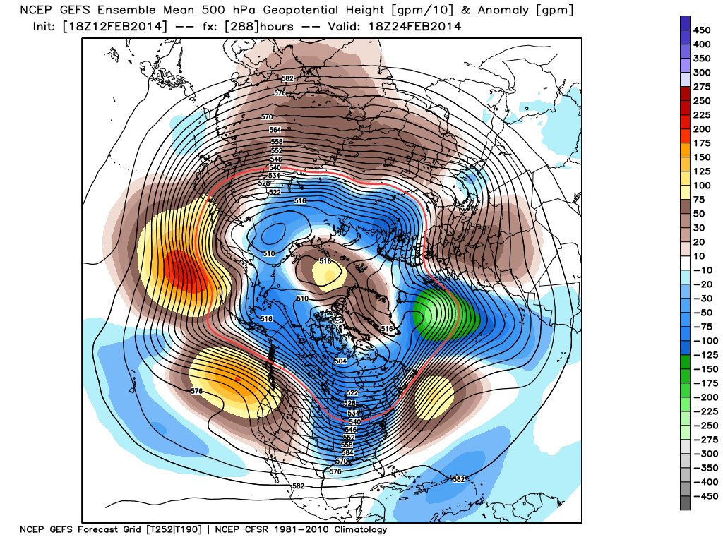
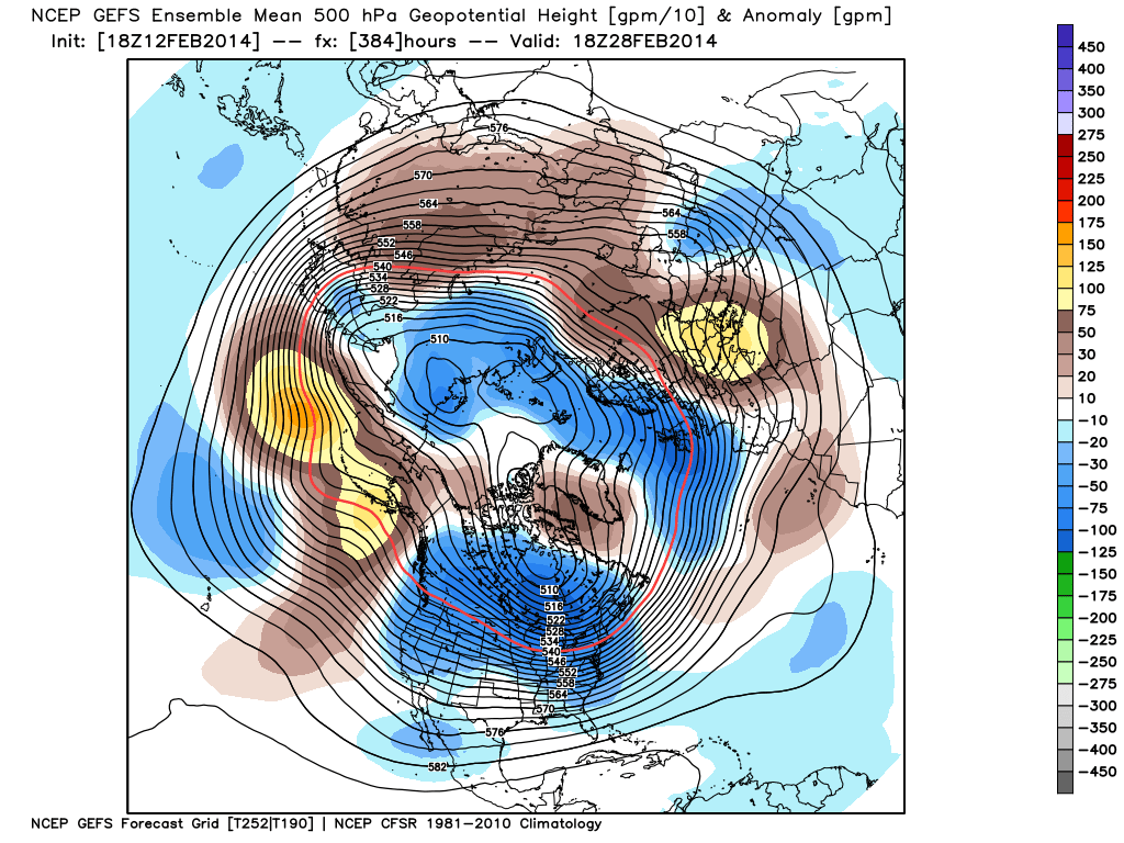
Finally, it should be noted that while a brief “relaxation” of the seemingly unending winter is on the way, the long term pattern continues to suggest a cold and wintry time of things continues overall.  Next week appears to be an “island of warmth in a sea of cold” type pattern.  Latest ensemble data continues to back this idea up.  That’s not saying we’re going to deal with the type of severe cold we’ve seen over the past several weeks, but instead means we’re going to go back below normal as we get set to wrap up February and head into March.

The latest GFS ensembles show the evolution of things well.  The “double secret probation” European model also shows something similar.

gefs_z500anom_nh_33gefs_z500anom_nh_49gefs_z500anom_nh_65

Note the ridge and associated spring “tease” is replaced with a cold and more wintry looking eastern trough rather quickly.  Circle the 24th on your calendar for the potential of a widespread storm system.  Far too early for details or questions, but the pattern looks to produce some busy times around this point.  Before that we have plenty of weather in front of us to deal with… weekend snow opportunities, foggy/ drizzly weather to accompany the initial surge of milder air next week, and a spring tease by late next week!

Snowy Weekend Ahead Or Not?

With today’s latest forecast model runs in house, we have excellent run-to-run consistency, the only problem is, that run-to-run consistency amongst each model continues to disagree with one another. We…

You must be logged in to view this content. Click Here to become a member of IndyWX.com for full access.  Already a member of IndyWx.com All-Access?  Log-in here.

“O Canada…”

A developing weather situation warrants our attention tonight and that’s the potential of a snow event Valentine’s Day.  The Canadian has led the way with this system and other forecast model data is beginning to follow it’s lead, slowly, but surely :-).

While we have time to continue to fine tune things, the trend is certainly one for the snowier over the past 12 hours.  That’s not saying we have complete agreement amongst all forecast models, but the overall pattern is one that has to at least raise an eye brow for accumulating snow potential across central Indiana Friday.

A clipper system will dive southeast out of Canada and into the Dakotas Thursday.  It’ll race southeast through the Plains states and into Missouri as early as Friday before tracking into the lower Ohio and Tennessee Valleys’ Saturday morning.  Clipper systems can always be challenging to track, but especially during the late winter and spring months.  The combination of lingering winter chill and the resurgent spring warmth can turn what may seem like a “harmless” wet snow event into a full-blown snow storm with little warning if one’s not paying attention.  That’s not saying this is the case with this particular event, but it is saying we have a close eye on things.  This will come on the front end of a brief, but significant, pattern change that will promote warmer than normal conditions across the region next week.  The tight thermal gradient can essentially help fuel this system as it moves southeast (whether or not this makes “the turn” and adds to the snow pack along the East Coast is yet to be seen).  Temperatures Saturday may approach 50 degrees across southwest Missouri Friday while here, across the “snow fields” of central Indiana, we remain locked in the 20s.

For now we’ll refrain from hoisting snowfall potential, but suggest you keep a close eye on the Friday and Saturday forecast and plan for the likelihood of at least some accumulation.  Stay tuned.

Clipper21414

Tracking Late Week Snow…

Tue.

Wed.

Thr.

Fri.

Sat.

Sun.

Mon.

 Status-weather-clear-icon

 Status-weather-clouds-icon

 Status-weather-clouds-icon

 Status-weather-snow-scattered-day-icon

 Status-weather-snow-scattered-day-icon

 Status-weather-clouds-icon

Status-weather-showers-scattered-icon

-12/ 1

0/ 27

9/ 36

22/ 30

12/ 28

14/ 29

25/ 39 

0.00”

0.00″

0.00”

1-2”

1”

0.00″

0.50”

Forecast Updated 02.11.14 @ 8:00a

Bitterly Cold Start…Take a look at the 8a central Indiana weather roundup, courtesy of the National Weather Service:

INZ030>032-037>040-046>048-054>057-064-065-111400-
CENTRAL INDIANA

CITY           SKY/WX    TMP DP  RH WIND       PRES   REMARKS
INDIANAPOLIS   MOCLDY    -4 -10  75 N3        30.46R
-EAGLE CREEK   MOCLDY    -8 -14  74 NW6       30.46R WCI -21
KOKOMO *+      PTCLDY   -20 -26  76 CALM      30.46R
MARION +       MOCLDY   N/A N/A N/A CALM      30.47S
MT COMFORT *+  PTCLDY   -17 -20  83 CALM      30.46R
SHELBYVILLE    PTCLDY    -9 -15  75 CALM      30.47R
ZIONSVILLE +   PTCLDY   -15 -22  71 CALM      30.46R

This just makes me shiver!  We note temperatures as low as 16 degrees below zero reported at Zionsville this morning just after 7 o’clock.  Today will be another brutally cold day, but sunshine will prevail.  Arctic high pressure will remain anchored over our region and result in another bitterly cold night tonight, but not as cold as it was last night/ this morning.

Midweek Moderation…We’ll begin to get into a westerly and southwesterly air flow Wednesday into Thursday in advance of our next snow maker.  While temperatures will remain below average levels, it’ll feel nice to go above freezing Thursday, albeit briefly.  Gusty southwest winds could offset the relatively milder feel Thursday, as gusts may approach 25-30 MPH by afternoon.

Meanwhile, a major winter storm will impact the Deep South and result in heavy snow and ice accumulations.  My old stomping ground of Johnson County, TN will likely accumulate 7-10″ of heavy, wet snow Wednesday into Thursday morning.

Tracking Two Snow Systems…We continue to have a couple questions around two snow makers Friday and Saturday.  The Canadian forecast model remains most aggressive in snow production, delivering a full-blown snow storm Friday with 4-6″ totals while the GFS suggests we struggle to accumulate 1″ Friday.  We’re continuing to go with a blend between the two, and side with the European model for now.  This would suggest 1-2″ of snow Friday followed by another fast moving clipper system Saturday that could deposit another 1″, or so.  Stay tuned as we continue to fine tune the Friday-Saturday forecast.

Milder Air, But Wet…Our next storm system will move in Monday and looks to primarily be a rain maker. Who thought highs approaching 40 (seasonal levels) would feel warm?!  After this brutally cold winter, it’ll feel just that!

images

For weather updates and more “behind the scenes” data on the go, be sure to Follow Us on Twitter @indywx or become a Friend of IndyWx.com on Facebook!

twic