Category: Forecast Discussion

Wintry Sandwich Sunday Evening-Monday; More Bitter Cold Follows.

Busy times continue in the good ole weather office as we get set to deal with yet another winter storm during the upcoming weekend.

First, we’ll deal with more below zero temperatures tonight and Saturday morning as overnight lows bottom out between 5 and 10 degrees below zero tonight area-wide.  Wind chill values, of course, will be even colder (-15 to -25).  Dangerous cold continues with considerable blowing and drifting in the open country.  Saturday will be the “calm before the storm” with unseasonably cold conditions continuing, but with lighter winds and sunshine.

Clouds will increase Saturday night into Sunday and we’ll begin to introduce precipitation into your forecast as early as Sunday afternoon (not a bad day for two classic back-to-back playoff games if you ask me).  Here’s our best idea of what you can expect statewide after reviewing all guidance today:

011115event


Some initial thinking would place the following numbers (a bit early to be too specific), and we caution this will have to be fine tuned as we move forward.

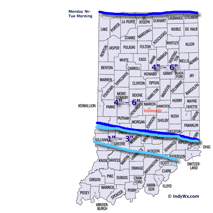
Snow accumulation of 2″-4″ across north-central Indiana, particularly just north of Indianapolis.  In the “mainly snow” zone, expect amounts of 3″-6″.  Ice storm criteria accumulation of freezing rain is possible (0.25″, or greater) across central Indiana, as well.  South of the city, early ideas suggest roughly 1″-2″ of snow and glaze potential closer to that potentially damaging 0.25″ amount.  Again, we state that these numbers are very early ideas and will have to be fine tuned.

Precipitation should initially overspread central Indiana Sunday afternoon in the form of sleet and snow (more sleet south-central, more snow north-central) before transitioning to more of a sleet and freezing rain event.  Finally, we anticipate the wintry mixture of precipitation to end as snow before moving out Monday morning.  Timing and duration of precipitation types will obviously determine how much ice and snow a given location sees.

Another big item we want to be sure to mention is that yet ANOTHER push of bitter arctic air will invade behind this storm and set the stage for another dangerously cold period Tuesday into Wednesday (back below zero we go)!

Stay tuned as we continue to fine tune the forecast over the weekend!

Permanent link to this article: https://indywx.com/wintry-sandwich-sunday-evening-monday/

Catching Up On Where We’ve Been And What Lies Ahead…

January is off to a frigid start. After a mild December, January is certainly reminding folks that there’s a lot of winter in this pattern. Precipitation is running above normal…

You must be logged in to view this content. Click Here to become a member of IndyWX.com for full access.  Already a member of IndyWx.com All-Access?  Log-in here.

Permanent link to this article: https://indywx.com/catching-up-on-where-weve-been-and-what-lies-ahead/

Monday Night-Tuesday Snow Event: First Call Map

15141614SnowfallForecast

I apologize for the lack of posts today.  My wife and I took time to get away for the weekend before the busy winter weather invades.  As a side note- it takes a special woman to put up with someone like me who has to check each and every model run through the day (and night).  I have an internal clock that causes me to wake up for the European run between 1a – 2a every night this time of year (pathetic, I know).  At any event, here are some of the quick-hitting bullet point highlights of what’s ahead into mid week:

  • Plowable Snow: Snow arrives into central IN by mid to late evening Monday and falls fast and furious for a few hours during the overnight.  Thinking here is that the majority of accumulating snow will fall after the evening rush Monday and before the morning rush Tuesday.  That said, it’ll be tough for snow removal companies and plows to keep up during the heart of the storm as snowfall rates will likely top 1″/hr during the overnight Monday.  Tuesday’s rush to and from work won’t be fun.  The snowfall map above is our best educated idea at this point, but we also think a localized band of 7″ – 8″ totals can’t be ruled out and we’ll use tomorrow to fine tune that band (early thinking is just north of the city).
  • Strong Winds: We’re still expecting wind and cold to become a huge story and concern Tuesday afternoon into mid week.  Northwest winds will become strong and gusty Tuesday and result in considerable blowing and drifting of snow (especially by afternoon).  Travel will likely remain difficult because of the combination of blowing, drifting, and the bitterly cold air.  Wind speeds will top 20-30 MPH Tuesday afternoon and night as the arctic front blows through.
  • Dangerous Cold: Temperatures will plummet Tuesday afternoon as the arctic air hits like a “wall.”  This will set the stage for dangerously cold air Tuesday night through Thursday, including below zero temperatures (5-10 below zero) and wind chill values that approach 30 degrees below zero.  Temperatures Wednesday will struggle to make it much above zero for the high (not a typo).

Permanent link to this article: https://indywx.com/monday-night-tuesday-snow-event-first-call-map/

Snow Showers Arrive Sunday; More Snow And Dangerous Cold Ahead…

Lots to discuss through the upcoming 7 days so please be sure to click the video and hear our latest thinking.  Have a great Saturday!

You must be logged in to view this content. Click Here to become a member of IndyWX.com for full access.  Already a member of IndyWx.com All-Access?  Log-in here.

Permanent link to this article: https://indywx.com/snow-showers-arrive-sunday-more-snow-and-dangerous-cold-ahead/

Stretch Of Severe Winter Weather Next Week.

Just wanted to touch on a couple of bullet points for the upcoming week before a more extensive forecast update a bit later this afternoon.  A period of severe winter…

You must be logged in to view this content. Click Here to become a member of IndyWX.com for full access.  Already a member of IndyWx.com All-Access?  Log-in here.

Permanent link to this article: https://indywx.com/stretch-of-severe-winter-weather-next-week/