
You must be logged in to view this content. Click Here to become a member of IndyWX.com for full access. Already a member of IndyWx.com All-Access? Log-in here.
Category: Forecast Discussion
Permanent link to this article: https://indywx.com/video-heavy-rain-threat-on-the-table-early-next-week/
Oct 18
VIDEO: 6-10 Day Harvest Outlook…
You must be logged in to view this content. Click Here to become a member of IndyWX.com for full access. Already a member of IndyWx.com All-Access? Log-in here.
Permanent link to this article: https://indywx.com/video-6-10-day-harvest-outlook-2/
Oct 16
VIDEO: 6-10 Day Harvest Outlook
You must be logged in to view this content. Click Here to become a member of IndyWX.com for full access. Already a member of IndyWx.com All-Access? Log-in here.
Permanent link to this article: https://indywx.com/video-6-10-day-harvest-outlook/
Oct 12
Colder Pattern Ahead To Close October; Open November?
October, month-to-date, has been nothing short of a blow torch. Officially, IND is running +9° through the 11th.
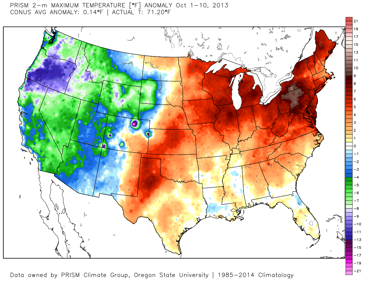
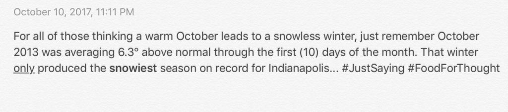
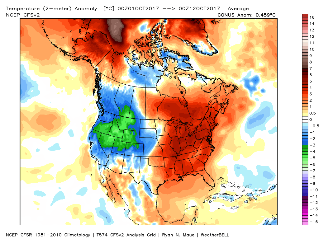 In coffee shops and my travels around the great state of Indiana, I’ve overheard lots of talk centered on because October has been so warm, another lackluster snow season awaits. Let us remind you that the infamous snow season of ’13-’14 featured a very warm first half of October.
 The upcoming 7-10 days will feature more of a transitional period of weather that we’ve come to know and love around these parts. Warmth will spread northeast this weekend ahead of an approaching cold front (around 80° Saturday) before falling temperatures Sunday afternoon behind the frontal passage. The chilliest air so far this season will descend upon the region early next week. That said, the chill won’t hold and another surge of above normal warmth will spread northeast by the latter parts of next week.
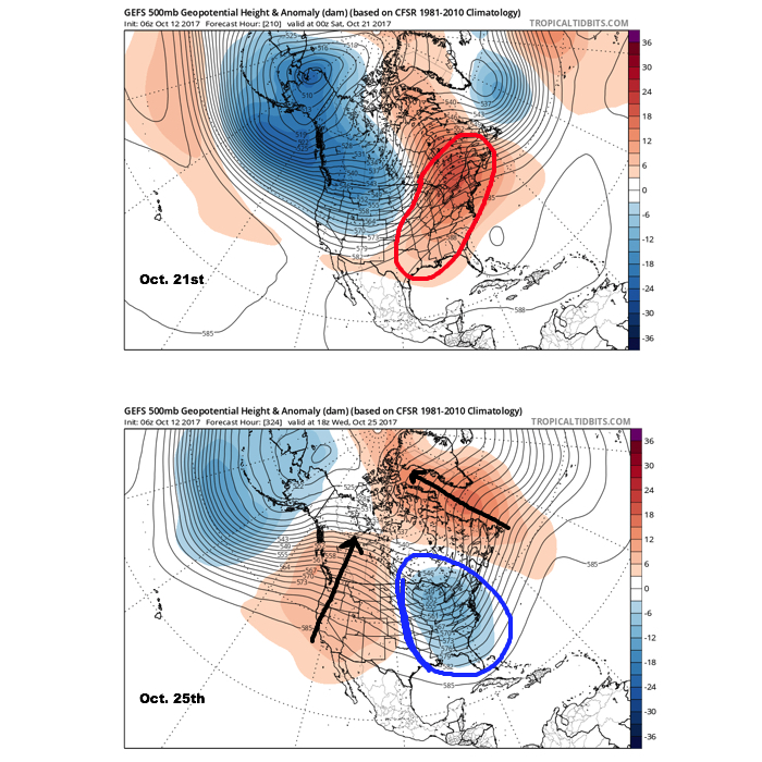
A more significant pattern change appears dialed up prior to Halloween and this is one that seems suited to lead to more prolonged and significant cold to wrap up the month and head on into November. Notice the evolution of things from October 21st to the 25th, courtesy of the GEFS off the fantastic tropicaltidbits.com. Other model data is in general agreement, leading to a rather high confidence level for this time period.
 It should also be noted that analog data and research also would lean heavily in the cold direction to wrap up October and these findings also favor a chilly November… More on that later! Speaking of later, an updated 7-day will be posted this evening. Make it a great day!
Permanent link to this article: https://indywx.com/colder-pattern-ahead-to-close-october-open-november/
Oct 10
Ups And Downs Of Autumn…
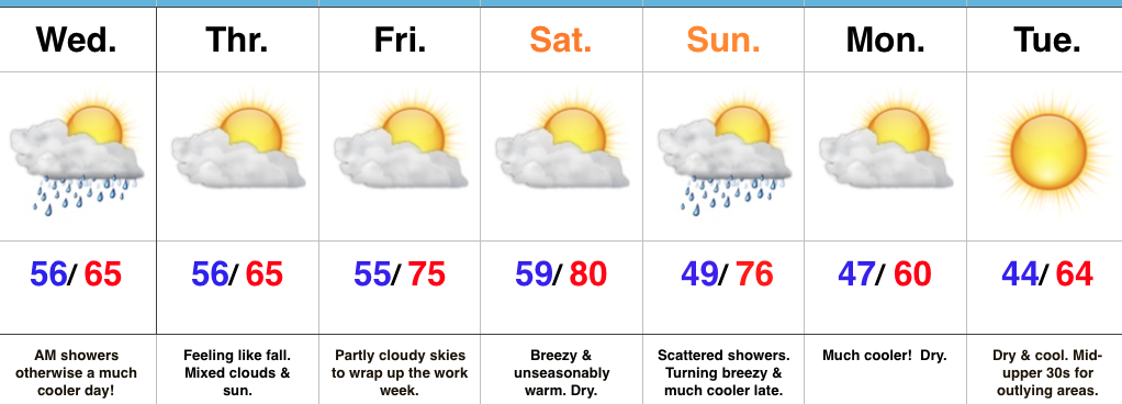 Highlights:
- Early morning rain ends
- Cooler air arrives
- Warm Saturday
- Much cooler close to the weekend
Buckle Up…Early morning showers and embedded thunder should press northeast of the region before the rush gets underway. All the same, expect damp roads on the way in to work and school Wednesday morning. Additionally, we’ll notice a much cooler feel to the day, including nearly steady or slowly falling temperatures. After a seasonable high Thursday, dry conditions and moderating temperatures will be with us to wrap up the work week.
Our next storm system will take aim on the region this weekend. Dry conditions will prevail Saturday, along with a gusty southwest wind that will help aid in boosting temperatures to around 80° (where’s that college football weather)?! That southwest (warm) wind will be in advance of an approaching cold front that will deliver scattered showers Sunday. Not everyone will get wet, but everyone will notice the much cooler close to the weekend. Temperatures will fall Sunday evening with a gusty north breeze.
Early next week will open dry and cool. – Just classic fall weather that most of us have come to know and love this time of year around these parts!
Looking ahead, there continue to be signs that point towards potentially a more significant shift in the weather pattern that would result in a rather dramatic cold transition to wrap up the month. More on this later.
Upcoming 7-Day Precipitation Forecast:
- Snowfall: 0.00″
- Rainfall: 0.25″ – 1.00″
Permanent link to this article: https://indywx.com/ups-and-downs-of-autumn/