Category: Forecast Discussion

Wednesday Notebook: Confidence Increases On The First Snowstorm Of The Season…

The first snowstorm of the season (and there will be many more where that came from) looms for the upcoming weekend across central Indiana- and a large portion of the Ohio Valley.

An area of low pressure will develop across the Texas panhandle Friday.  This area of low pressure will scoot across the Ozark Mountains Saturday and into the Tennessee Valley Sunday.  As this takes place, a shield of snow will grow in coverage and intensity across Missouri Friday afternoon, spreading northeast overnight Friday into Saturday.  “Forcing” will eventually weaken late Saturday night into Sunday morning and drier air will eventually filter into the area.  Before this though, a solid 12 hours of steady snow is possible for much of central Indiana Saturday.

Notes:

  • While far from set in stone on specific snowfall numbers across central Indiana, it’s safe to say plows, shovels, and snowblowers will be needed across the region. 🙂  Confidence will be high enough to issue our first call later Thursday.
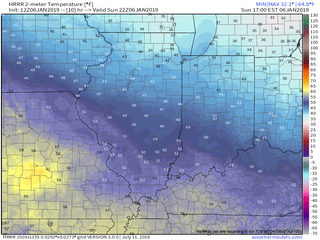
  • We anticipate the onset of snow to reach west-central parts of the state around 5a before moving into the city, itself, around 6a to 7a.
  • Periods of moderate to even heavy snow will develop Saturday afternoon.  If you have travel plans, we recommend getting those out of the way early Saturday morning.  If your travels take you west to the big game this weekend, plan on leaving tomorrow of predawn Friday to avoid having to deal with slippery roads.
  • Finally, we’re not at all concerned about the high “suppressing” things this go around.  The overall pattern is much different from the “suppression depression” event we were jumping all over (and getting ridiculed by some, mind you, for betting against the snow ;-)) earlier this winter.  If anything, given the overall support for this storm system, things may trend a tick or two north over the next 24-48 hours.  Regardless, this should be an impactful event for central Indiana.

More later.  In the meantime, may we recommend your Saturday plans include a pot of chili and roaring fire to go along with Colts football?  Sounds like the perfect day to me!

Permanent link to this article: https://indywx.com/wednesday-notebook-confidence-increases-on-the-first-snowstorm-of-the-season/

First Widespread Snow Event of the Season…

The first widespread Ohio Valley snow event of the season is on deck this weekend…

You must be logged in to view this content. Click Here to become a member of IndyWX.com for full access.  Already a member of IndyWx.com All-Access?  Log-in here.

Permanent link to this article: https://indywx.com/first-widespread-snow-event-of-the-season/

Weekend Threat: Subtle Differences Make All The Difference…

We wanted to take a quick opportunity to discuss the weekend snow threat. While certainly on the table, it’s far from etched in stone. We note the models doing their usual “herky-jerky” moves 5-6 days out. At the end of the day, there’s a notable threat present, but we prefer to watch things unfold over the next few days before beginning to get too excited.

Subtle differences between the European model (image 1) and GFS (image 2) are seen in the handling of the 500mb pattern. The GFS is quicker to phase the upper energy and leads to a more robust system.  The European isn’t nearly as excited and instead dampens the energy coming east.  These seemingly minute differences can make all the difference when it comes to the sensible weather that may (or may not) impact your weekend plans.  If the European is correct, this is a rather non-event, locally.  However, should the GFS idea be correct, this will be a widespread Ohio Valley snow event that’ll require gassing up the snow plows…

The European model weakens the energy coming east needed to fuel a more substantial storm Friday into Saturday.

The GFS model bundles the upper energy and phases things- leading to a more significant wintry threat by Saturday.

Stay tuned as we’re still a few days out from having confidence needed to begin to sound the alarm. 😉

In the longer range, tonight’s data continues to head in the direction where winter will make up for lost time to close January and head on into February.  Delayed, but not denied…

Permanent link to this article: https://indywx.com/weekend-threat-subtle-differences-make-all-the-difference/

Rain By Lunchtime And More Active Times In The Days Ahead…

Rain will overspread the state early afternoon and most area rain gauges can expect to accumulate between one tenth and one quarter inch by this evening. Tuesday is a day…

You must be logged in to view this content. Click Here to become a member of IndyWX.com for full access.  Already a member of IndyWx.com All-Access?  Log-in here.

Permanent link to this article: https://indywx.com/rain-by-lunchtime-and-more-active-times-in-the-days-ahead/

Week Ahead Outlook: Relatively Quiet Times Remain…

I. Today won’t feature nearly as much sunshine as we enjoyed Saturday, but considering it’s early-January, we can’t complain about mid-upper 40s and dry conditions.  Morning fog in spots will burn off to increasing mid and high level cloudiness today ahead of our approaching Monday storm system.

II. A cold front will push rain back into the state as we open the work week.  Rain will reach greatest coverage around the lunchtime hour into the early afternoon.  Overall, central Indiana rain gauges can expect to accumulate somewhere between 0.10″ and 0.25″ Monday.

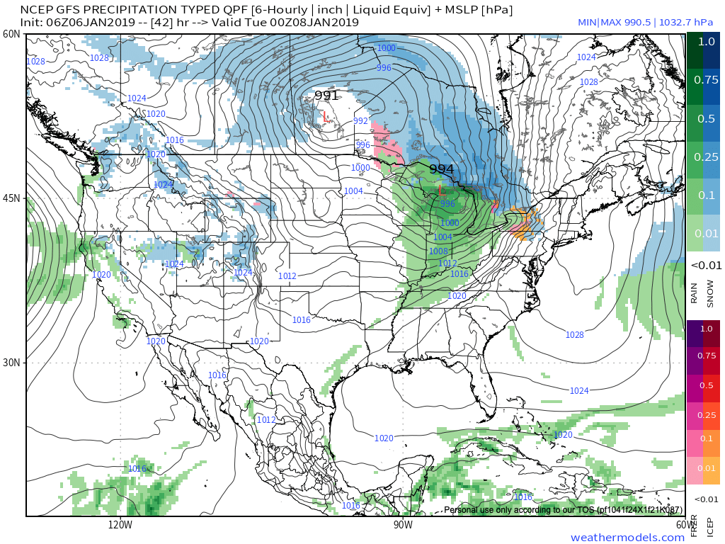
Note this storm system won’t have a Gulf of Mexico (GOM) connection. Thus, the reason behind the lighter rainfall numbers compared to recent events.

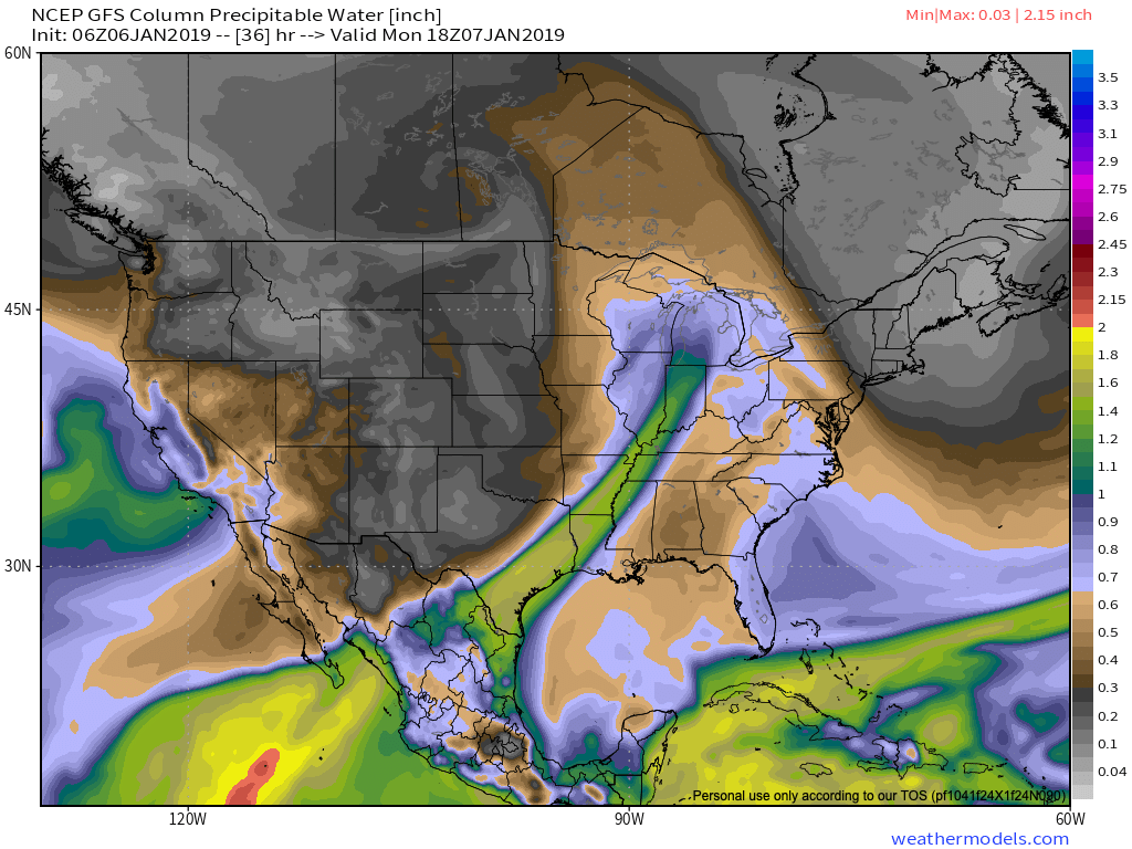
III. Colder air will pour in behind the storm system.  Highs will struggle to reach the freezing mark Wednesday and Thursday. Dry times return.

IV. A weak system may deliver rain or snow next weekend, but modeling differs on how they handle this energy.  We’ll keep an eye on things and update accordingly.

Permanent link to this article: https://indywx.com/week-ahead-outlook-relatively-quiet-times-remain/