
You must be logged in to view this content. Click Here to become a member of IndyWX.com for full access. Already a member of IndyWx.com All-Access? Log-in here.
Category: Forecast Discussion
Permanent link to this article: https://indywx.com/video-discussing-the-severe-localized-flooding-threat-tonight-and-looking-ahead-to-the-holiday-weekend/
May 17
Risk Of Rotating Storms This Evening-Tonight…
Quick short-term update this morning to discuss the potential of severe weather later this evening and into the nighttime hours. (We’ll have a more in-depth video update posted this evening, including longer range thoughts).
This morning has featured a few rain showers scattered about central Indiana, but the heavier, more organized, rain from the overnight is long gone (for now). While showers will impact central Indiana at times into the early afternoon hours, it’s not until late evening and the nighttime hours that we anticipate more organized shower and thunderstorm activity. Given the ingredients in place, there’s the potential of a few rotating storms tonight and subsequent risk of tornadoes. Sunshine, or not, it’ll be important to remain weather-aware tonight and have a means of getting the latest warnings that may be issued. Should we see a period of sunshine later this afternoon, the threat of severe weather will be elevated tonight.
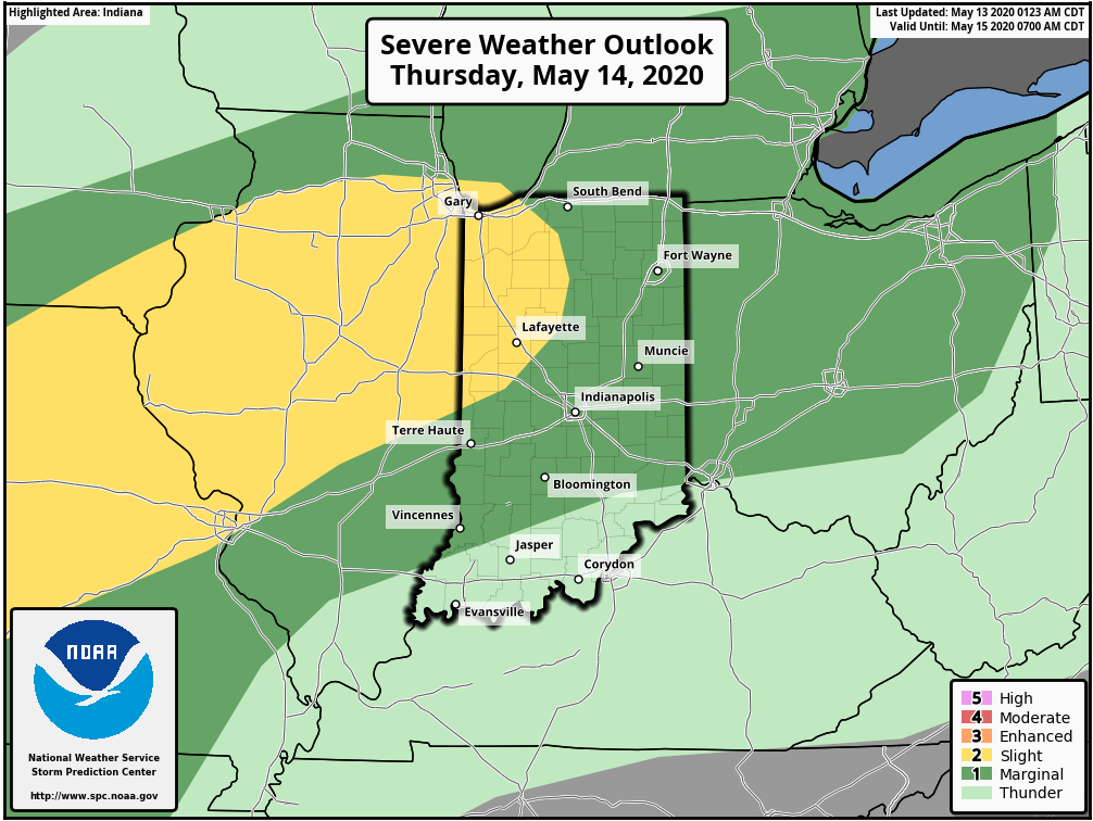
The Storm Prediction Center (SPC) includes central and western portions of the state in a Slight Risk of severe weather in their most recent Day 1 Outlook.

The window of severe weather potential appears to come after 8p for central Indiana, continuing into the overnight hours.

Locally heavy rain will shift from western Indiana (tonight) into the eastern half of the state (Monday). Widespread 1″ to 2″ of additional rain is likely.

As the upper low “cuts off” early-mid week, shower chances will continue along with cooler temperatures.
Make it a great Sunday! Chat with y’all a bit later today!
Permanent link to this article: https://indywx.com/risk-of-rotating-storms-this-evening-tonight/
May 16
VIDEO: Gorgeous Saturday; Storms Return Tonight And Looking Ahead Towards Memorial Day Weekend…
You must be logged in to view this content. Click Here to become a member of IndyWX.com for full access. Already a member of IndyWx.com All-Access? Log-in here.
Permanent link to this article: https://indywx.com/video-gorgeous-saturday-storms-return-tonight-and-looking-ahead-towards-memorial-day-weekend/
May 14
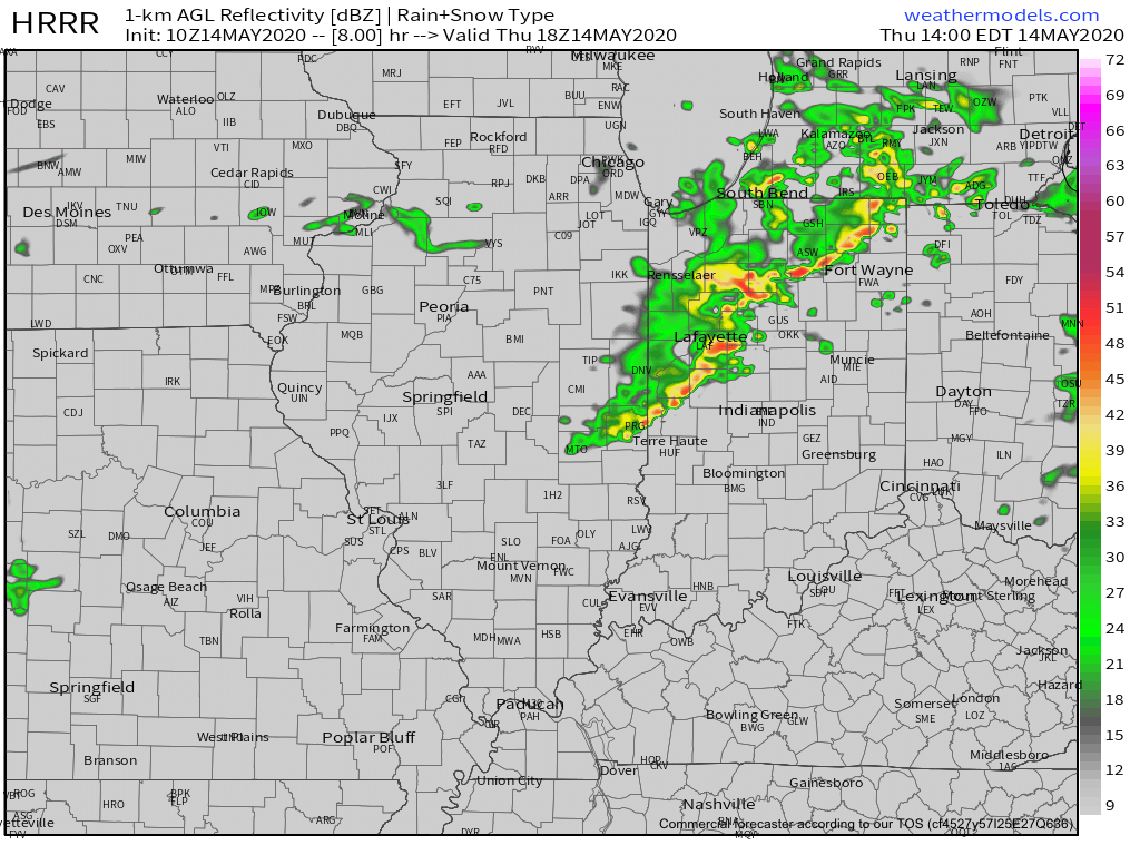
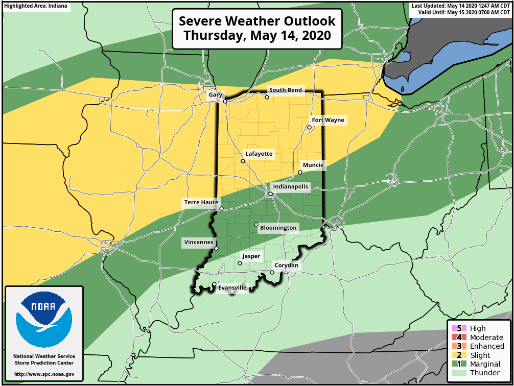
Thursday Morning Rambles: Storms Accompany Warmth; Interesting “Twist” To The Longer Range…
I. After a cold and dry open to May, (Month-to-date, Indianapolis is running 8.4° below avg. and 1.24” below normal in the precipitation department) changes have arrived.

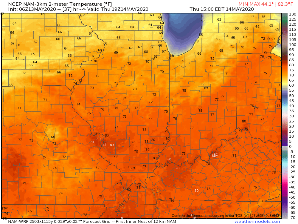
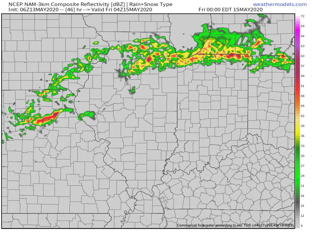
II. A warm front will lift north through the state today and deliver those warmer changes. The transition from cool to more of an early summer feel will be met with a couple rounds of storms today. Some of those storms will be strong to severe (damaging winds being the greatest concern), especially north of the city. Strongest storms should arrive across the northern half of the state during the early to mid afternoon hours.
III. A “half-n-half” weekend is expected. After a wet Friday, drier air is expected to arrive to help us out Saturday. Showers and storms will return Sunday courtesy of a cold front and associated surface low. Locally heavy rainfall will be possible Friday & Sunday and when you add in what falls today, most of the state from the city and points north can expect widespread 2”-2.5” with locally heavier amounts.

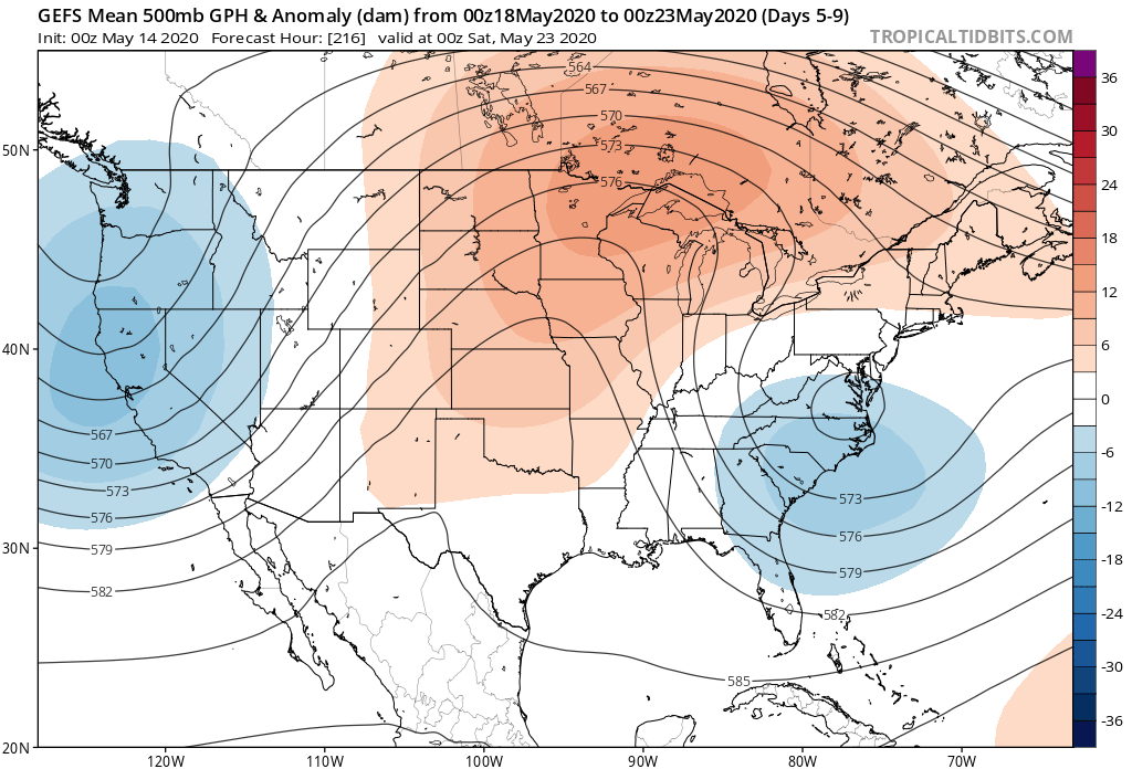
IV. An area of low pressure and upper level trough is now shown to “cut off” over the Mid-Atlantic region in the medium range period. This is forecast to dramatically cool the Monday through Thursday time frame (instead of 80s, we’re now talking upper 50s, 60s and low 70s during the period). This is worth keeping an eye on as models can struggle handling these kind of features, but as it stands now, after a brief encounter with warmth this weekend, it doesn’t appear as if we’ll get back to the heat until Memorial Day weekend.
Permanent link to this article: https://indywx.com/thursday-morning-rambles-storms-accompany-warmth-interesting-twist-to-the-longer-range/
May 13
Off To The Races; Warmth Met With Periodic Storms…
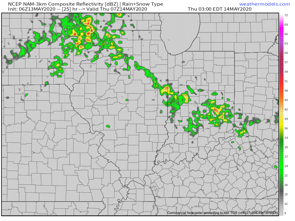
A band of light showers is falling across southern Indiana this morning, but these are expected to diminish before pushing into central Indiana. Most of the remainder of our Wednesday should be rain-free.
The quiet times will give way to a couple of rounds of storms during the overnight and into Friday. Most notably for central Indiana, we think storm chances will increase significantly after midnight and through the predawn hours Thursday. Locally heavy rain and vivid lightning is expected with the stronger storms.
These storms are in association with a warm front lifting north through the state. Speaking of warm, we’ll certainly notice a difference in air masses between today (still relatively cool and dry) and tomorrow (much warmer and more humid). In fact, highs Thursday will flirt with 80° across most of central Indiana.
Once we get rid of the early morning storms, most of the remainder of our Thursday will be dry and feature a return of the sun.
Another round of storms is expected Thursday night into Friday, but most of these will remain well north of our area. A few of these could become severe across northwestern Indiana during this period.
Rain and storm chances will increase once again during the day Friday across central Indiana. A few strong storms will be possible.
As we look ahead to the weekend, it appears we’ll be able to enjoy a mostly dry day Saturday (widely scattered storm possible) before more widespread storms return Sunday. Warm and humid conditions will prevail. A cold front will move through the area early next week which will allow for briefly cooler, drier air to move in during the 1st half of next week. Before that takes place, rainfall amounts between tonight and Sunday are expected to range from 1.5” – 2” with locally heavier totals across central Indiana. Heavier rainfall amounts can be expected across northern Indiana (widespread 3” to 4” amounts during the same period).
Permanent link to this article: https://indywx.com/off-to-the-races-warmth-met-with-periodic-storms/