Category: Forecast Discussion

Tuesday Forecast: A Brilliant Day Ahead!

Updated 09.16.13 @ 10:50p

Zionsville, IN We’ll enjoy a cool and refreshing start to your Tuesday and this is only the beginning of what will be an absolutely “brilliant” weather day here across central Indiana. We discuss increasing warmth, humidity, rain chances, and look ahead to your weekend below!

Capture

Brilliant Tuesday: The title pretty much sums it up! We look for bright blue skies today and very pleasant temperatures. After a cool and crisp start, temperatures will moderate into the lower 70s for afternoon highs. If you can be outdoors today, make it happen!

Heat and Humidity Increase: A warm front will lift north across the region Wednesday and as this front moves through, look for clouds to increase along with a widely scattered shower or thunderstorm. As of now, we bracket the morning and early afternoon hours Wednesday for the best chance of getting wet, and even that isn’t a great chance. We think only 20%-30% of the viewing area receives rain Wednesday. Otherwise, we’ll feel a much more humid and warmer air mass by the afternoon. This continues Thursday with a scattered shower. Highs Thursday will draw close to 90°.

Friday Cold Front: A cold front will slice into the warm and humid air mass of mid week and this will lead to the best chance of significant, widespread rainfall we’ve seen around these parts in weeks. At this stage, as much as 0.50″-0.75″ looks likely across all of central Indiana Friday as the front moves in. Best chances of getting wet appear to arrive Friday evening (I know, I know…right in the middle of high school football). We’ll continue to monitor.

Cool, Dry Weekend: If you enjoyed last weekend then you’re sure to fall in love with this upcoming weekend. A cooler and drier air mass will move in for the weekend along with lots of sunshine and dry skies.

Permanent link to this article: https://indywx.com/2013/09/16/tuesday-forecast-a-brilliant-day-ahead/

Rambling Around Between Games…

As we alluded to in the post earlier this morning, the weather pattern is beginning to get more active. As “seasoned” Hoosiers know, this is only the beginning of a rather “vamped up” weather period through the next 7-8 months around these parts. Yes, the lazy, hazy days of summer in the weather office are over.  Speaking of the weather office, I’m continuing to get settled into the new “home base” office. As I get settled, more and more products will begin to hit the site to help keep central Indiana Hoosiers abreast of what lies ahead in the weather department.

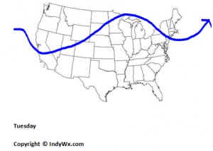
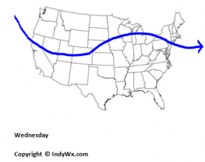
As we look at the upcoming week, we’ll note the trough and dominant northwesterly flow of the weekend begins to “relax” by mid week and weak ridging takes it’s place. This will lead to a warmer and more muggy (though nothing close to as oppressive as last week) feel to the air by mid week. We also note another dip in the jet by next weekend. While details still have to be ironed out, there’s a good shot of rain due in here by week’s end along with another cool down by next weekend. I also want to point out the re-curving typhoon out in the western Pacific.  This is in association with upper level ridge placement in the Pacific Ocean and we can actually use this tool to help us forecast weather here on the “home front” in the 6-10 day period. That would bring us roughly to 09.25.13 (give or take a couple of days) and would line up nicely with the cool end of the month we’ve been talking about for some time.  Recall that we’ve said we anticipate a warmer than normal month to continue (in the overall pattern sense) up until the last 5-7 days of the month. Does this help set the stage for a colder than average October ahead? Stay tuned…

Here’s a look at our precipitation outlook, compiled this afternoon using a variety of short and mid range forecast models.

precip

Watch how the troughs (cooler air) and ridging (warmer air) correlate with the temperature pattern in our official forecast (posted earlier this morning).

Monday

mondayjet

Wednesday

wednesdayjet

 Friday

fridayjet

Saturday

saturdayjet

Permanent link to this article: https://indywx.com/2013/09/15/rambling-around-between-games/

Wetter Pattern Looming?

Short term drought conditions continue to expand and worsen for many communities across central Indiana. From an agricultural stand point, negative impacts (slightly to moderately so) are being experienced on…

You must be logged in to view this content. Click Here to become a member of IndyWX.com for full access.  Already a member of IndyWx.com All-Access?  Log-in here.

Permanent link to this article: https://indywx.com/2013/09/13/wetter-pattern-looming/

Friday Forecast: Grab The Jacket!

Updated 09.12.13 @ 4:59p

Zionsville, IN A series of cold fronts sweep the state tonight.  This will help usher in our first true taste of autumn for the season, just in time for another special football weekend ahead!  Don’t get used to the chilly conditions as resurgent heat, and better rain chances lie ahead. We discuss below!

Capture

Chilly Air Blows Into Town: A series of cold fronts are in progress of blowing through central Indiana. One is already through with another waiting in line. This secondary cold front packs some chilly air behind it and will result in temperatures in the upper 40s for many come morning.  Talk about stark contrast from heat indices in the 100s earlier this week!  We’ll note some instability-driven puffy cumulus clouds forming during the afternoon, but these will clear and give way to a calm, chilly night. Overnight lows Saturday morning will fall into the 30s for outlying areas.

Weak Cold Front Sunday: A weak cold front will lead to afternoon clouds and the threat of an isolated thunderstorm Sunday afternoon/ evening. We think 80-90% of the coverage area remains rain-free for now, but we’ll keep an eye on things and update accordingly.  This boundary will be responsible for keeping things dry and pleasant through early next week.

The Heat Returns: While we don’t anticipate anything nearly as brutal as this past week’s stretch of heat, the thermometer will flirt with the 90 degree mark once again come Wednesday.  Strong southwest winds will blow a warmer, more humid brand of air north bound for mid week and have overnight lows only falling into the lower 70s. A cold front will approach the region late next week, leading to what appears to be some scattered to numerous showers and thunderstorms by next Thursday.

Follow us on Twitter: @IndyWx

Friend us on Facebook: search IndyWx.com

Permanent link to this article: https://indywx.com/2013/09/12/friday-forecast-grab-the-jacket/

Thursday Forecast: Big Time Cool Down To Close The Week!

Updated 09.11.13 @ 10:06p

Zionsville, IN After three brutally hot late summer days, I know most are looking forward to a big time change for the cooler as we close out the work week and head on into the weekend!  We talk temperature changes, slim chances for some badly needed rainfall, and another stretch of heat next week!

7day091113

Cold Front Blows Through Later This Morning: A strong cold front will usher in a true taste of autumn just in time for another special football weekend ahead!  We bracket the wee morning hours through late morning for the chance of a shower or embedded rumble of thunder as the cold front blows through central Indiana.  That said, we’re only looking at a broken line of precipitation and don’t think every neighborhood gets wet.  Those that do see rain, don’t look for anything too terribly impressive, with most precipitation totals under two tenths of an inch. Winds will then shift out of the northwest and gust upwards of 20 MPH during the evening, helping the drastically cooler air settle in. Temperatures will actually fall during the afternoon, after early highs in the upper 70s.

Brilliant, Fall-Like Late Week: Despite a few puffy cumulus clouds Friday, expect dry conditions extending into Saturday with lots of sunshine. Temperatures will run roughly ten degrees below normal. In fact, Saturday morning will be particularly chilly, especially considering the simmering heat earlier this week. Some outlying communities will likely fall into the upper 30s. Highs both Friday and Saturday will only make it into the upper 60s. – Sounds like a perfect weekend to grab a Pumpkin Spice Latte prior to kickoff of your favorite football team!

Sunday Shower? A weak cold front will slide through the region Sunday evening. Clouds will increase with this boundary and we’ll keep an eye on precipitation chances as we move forward. That said, for now, we only think a widely scattered shower is possible Sunday. Most stay dry.

Resurgent Warmth Next Week: As we’ve been saying for weeks, we’re still in a warm pattern, overall, and don’t see any significant changes until potentially late in the month (say the last 5-7 days). Ridging rebuilds by the middle part of next week and moderating temperatures will ensue. We anticipate highs flirting with the 90 degree mark by Wednesday.

Follow Us On Twitter: @IndyWx

Friend Us On Facebook: search IndyWx.com

Permanent link to this article: https://indywx.com/2013/09/11/thursday-forecast-big-time-cool-down-to-close-the-week/

Wednesday Jet Stream Discussion

We use the Jet stream as one of many tools to help us forecast the weather in the days to come. A new feature here at IndyWx.com will be a Jet Stream Discussion, updated a few times every week to help you, the viewer, get a better idea of what to expect in the week ahead!

thursdayjet

fridayjet

saturdayjet

sundayjet

mondayjet

tuesdayjet

wednesdayjet

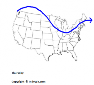
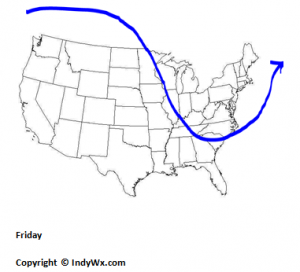
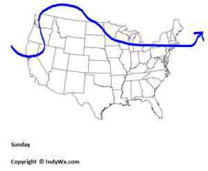
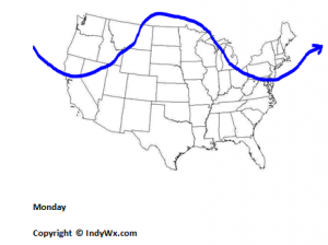
Note that the upcoming (7) day period will feature many “ups and downs” in the jet stream pattern.  This is indicative of the changing of the seasons and very typical of the approaching fall season.  Unseasonably cool air will be associated with the dip (known as a trough in the meteorological world) in the jet stream Thursday through Saturday. Temperatures will fall through the day tomorrow, after morning highs in the middle to upper 70s, and Friday and Saturday will feature air temperatures well below normal (by some 10 degrees).  That said, the cool weather is “transient” and will be out of here almost as quick as it arrives.  We’ll warm back to seasonable and above average levels during the early to middle part of next week as ridging builds into the Mid West and Ohio Valley region.  In fact, temperatures well into the 80s to near 90 degrees can be expected by the middle/ latter part of next week.

As for precipitation, we anticipate a broken line of showers and embedded thunder to push into the region with the cold front later tonight and Thursday (not a big deal and most won’t get wet). On average, those that do see rain will only muster a couple tenths of an inch.  The next best chance of precipitation isn’t until late next week.

We hope you enjoy these hand drawn maps.  The way weather information is provided to you, the viewer, seems to become more and more digital with less of the “human influence.” Our goal, as always, here at IndyWx.com is to keep the human element in the forecast products you see here.

Our full forecast package will be updated later tonight.  Have a nice and relaxing Wednesday evening and be sure to follow us on Twitter- @indywx or like us on Facebook (IndyWx.com).

Permanent link to this article: https://indywx.com/2013/09/11/wednesday-jet-stream-discussion/

Couple House Keeping Notes

Good evening, Indy! I hope this finds you having enjoyed a relaxing weekend! It’s been a busy and hectic weekend here (always made special with an Auburn victory), as I’ve…

You must be logged in to view this content. Click Here to become a member of IndyWX.com for full access.  Already a member of IndyWx.com All-Access?  Log-in here.

Permanent link to this article: https://indywx.com/2013/09/08/couple-house-keeping-notes/

Teleconnections Mean More At Different Times Of The Year

In the weather community you hear certain terminology being thrown around frequently. If you’re heavily into reading about or keeping up with the weather then I’m sure you’ve heard terms…

You must be logged in to view this content. Click Here to become a member of IndyWX.com for full access.  Already a member of IndyWx.com All-Access?  Log-in here.

Permanent link to this article: https://indywx.com/2013/09/07/teleconnections-mean-more-at-different-times-of-the-year/

PNA Set To Rule

The upcoming week will make a run at one of the hottest five day stretches, compared to average, all summer long. (Keep in mind though we’ve flipped over into meteorological…

You must be logged in to view this content. Click Here to become a member of IndyWX.com for full access.  Already a member of IndyWx.com All-Access?  Log-in here.

Permanent link to this article: https://indywx.com/2013/09/06/pna-set-to-rule/

Struggling Forecast Models

Zionsville, IN In an update back on 08.28.13 we posted an image of the GEFS and the cooler trend portrayed on that particular model. From 08.28.13… The latest update… As…

You must be logged in to view this content. Click Here to become a member of IndyWX.com for full access.  Already a member of IndyWx.com All-Access?  Log-in here.

Permanent link to this article: https://indywx.com/2013/09/05/struggling-forecast-models/

IndyWx.com