Category: Forecast Discussion

Busy Pattern…

A busy weather pattern will keep us on our toes with two storm systems of note between now and Saturday.

Periods of showers will keep most of today wet.  While it won’t rain the entire time, periods of moderate to heavy showers are possible today.  A quick punch of milder air will arrive this afternoon after a chilly start to the day, combined with a strengthening south wind.  Total rainfall today and tonight should average half an inch, or less.

Highs today will reach the lower 50s, despite the showers.

hires_t2m_max_indy_9

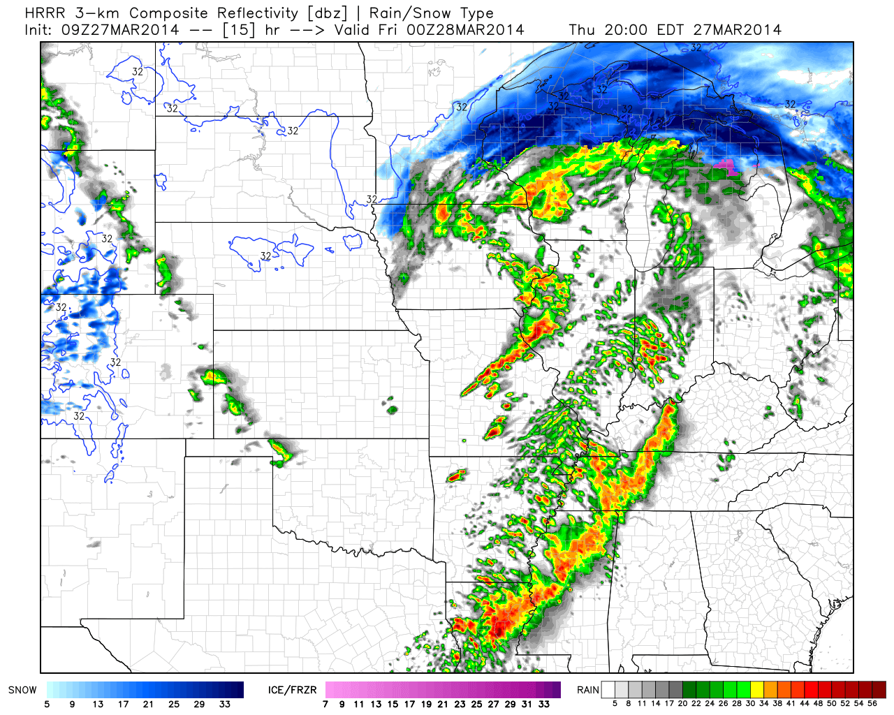
Latest simulated radar data shows the potential of a line of thunderstorms moving through here late tonight, directly associated with the cold front.  A strong storm is possible along with gusty winds as the front slides through early Friday morning.

hires_ref_mw_24hrrr_ref_mc_16

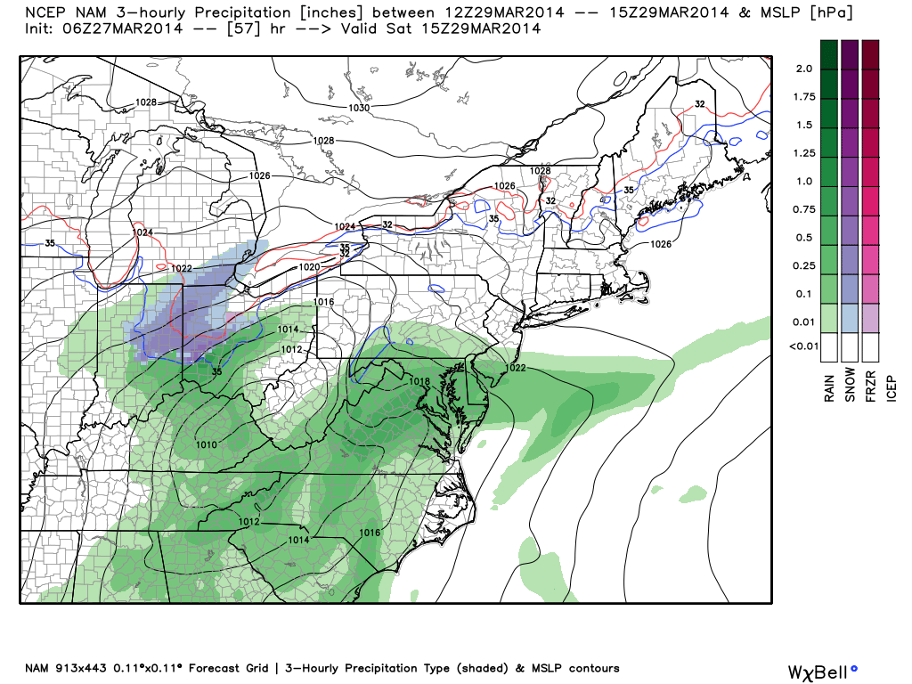
As if all of this wasn’t enough, another storm system will arrive Saturday.  This system will have a wintry component to it, with the chance of a stripe of wet snow along the northern shield of precipitation.  It’ll require our attention as we move forward.  March storms have been known to have a surprise or two and it’s our job to try and help eliminate any of these surprises.

nam_ptype_slp_ma_20


Permanent link to this article: https://indywx.com/2014/03/27/busy-pattern/

Active Pattern…

Wed.

Thr.

Fri.

Sat.

Sun.

Mon.

Tue.

 Status-weather-clouds-icon

 Status-weather-showers-scattered-icon

 Status-weather-showers-day-icon

 Status-weather-showers-scattered-icon

 Status-weather-clouds-icon

 Status-weather-showers-day-icon

 Status-weather-clouds-icon

17/ 40

30/ 50

39/ 52

32/ 39

28/ 56

39/ 62

31/ 49

– – –

Light

Light

Moderate

– – –

Light

– – –

Forecast updated 03.25.14 @ 7:30a

Brighter Mid Week. . .After a cold and snowy Tuesday, sunshine returns today and will help temperatures get a boost…somewhat.  Average high temperatures are in the upper 50s this time of the year and we’ll struggle to eclipse the 40 degree mark today.  That said, we’ll concentrate on the improvement from Tuesday.  Additionally, we’ll notice a strengthening southwesterly breeze during the afternoon, including gusts that may top 20 MPH.

Late Week Storm System. . .Low pressure will lift out of the Plains and into the Great Lakes Thursday. A warm front will lift north through our area early Thursday morning and will be accompanied by a quick burst of rain (potentially mixed with wet snow during the onset).  Finally, a cold front will drive through here late Thursday night into early Friday with shower chances continuing until the front passes.

Busy Times Continue This Weekend; Tricky Storm. . .While we may see some sunshine Friday afternoon, clouds will quickly build back in Friday night and rain will overspread the region, continuing into Saturday.  Rainfall may be heavy at times Saturday morning.

The early consensus of the track of Saturday’s low combined with marginal temperatures, does at least raise an eye brow that some wet snow could be in play for portions of central and east-central Indiana Saturday morning into the afternoon and we’ll monitor this.  Again, while temperatures will be marginal, at best, heavy precipitation rates will stand the chance for a band of heavy wet snow along the northern periphery of the precipitation.

Another Fast Moving Storm. . .After a drier Sunday (and milder), clouds return Sunday night and scattered showers are possible Monday as yet another cold front swings through the region.  Moisture will be limited with this front so rainfall amounts should be light.  Tuesday looks drier and colder.

Upcoming 7-Day Precipitation Forecast:

  • 7-Day Rainfall Forecast: 1″ – 1.50″
  • 7-Day Snowfall Forecast:  Less than 1″

twicFor weather updates and more “behind the scenes” data on the go, be sure to Follow Us on Twitter @indywx or become a Friend of IndyWx.com on Facebook!

images

Permanent link to this article: https://indywx.com/2014/03/25/active-pattern/

Out Of Season Cold…

Mon.

Tue.

Wed.

Thr.

Fri.

Sat.

Sun.

 Status-weather-clouds-icon

 Status-weather-snow-scattered-day-icon

 Status-weather-clouds-icon

 Status-weather-showers-scattered-icon

 Status-weather-showers-day-icon

 Status-weather-clouds-icon

 Status-weather-clouds-icon

18/ 37

25/ 33

19/ 40

34/ 42

39/ 58

37/ 46

28/ 60

– – –

Light

– – –

Light

Light

– – –

– – –

Forecast updated 03.24.14 @ 12:00a

Unseasonably Cold And Tracking Snow. . .It sure won’t feel like late March around these parts to kick off the new work week. Instead, we’ll deal with a biting north wind and temperatures more comparable to January.  Needless to say, certainly plan to grab the coat on the way out the door.

As we move into the evening hours clouds will begin to increase and light snow and scattered snow showers will arrive tonight into Tuesday morning.  This won’t be a big deal and we’re still anticipating little, if any, accumulation for most (perhaps up to half an inch in localized spots).  All the same, for a region that’s been brutally cold and snowy for month on end, this probably won’t be a welcome with “arms wide open” type of forecast.

South Winds Deliver Warmer Air. . .A gusty southwest wind will blow milder air north into the region Thursday. Along with the milder air will come moisture and we forecast showers to develop Thursday with a potential thunderstorm Thursday night into Friday morning as a cold front slides through the region.

Nice Weekend. . .Though Saturday will be colder than normal, sunshine should return for the weekend.  Furthermore, we’ll enjoy a southerly flow of air by Sunday which may help temperatures reach close to 60!

Upcoming 7-Day Precipitation Forecast:

  • 7-Day Rainfall Forecast: 0.50″
  • 7-Day Snowfall Forecast: Less than 1″

twicFor weather updates and more “behind the scenes” data on the go, be sure to Follow Us on Twitter @indywx or become a Friend of IndyWx.com on Facebook!

images

Permanent link to this article: https://indywx.com/2014/03/24/out-of-season-cold/

Where We’ve Been And Where We’re Going…

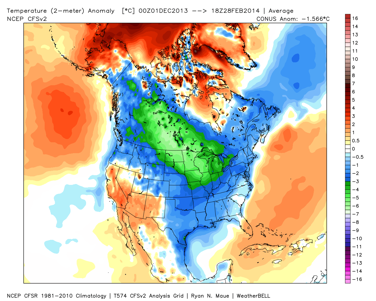
It was a cold winter across the Lower 48, including Indiana:

2

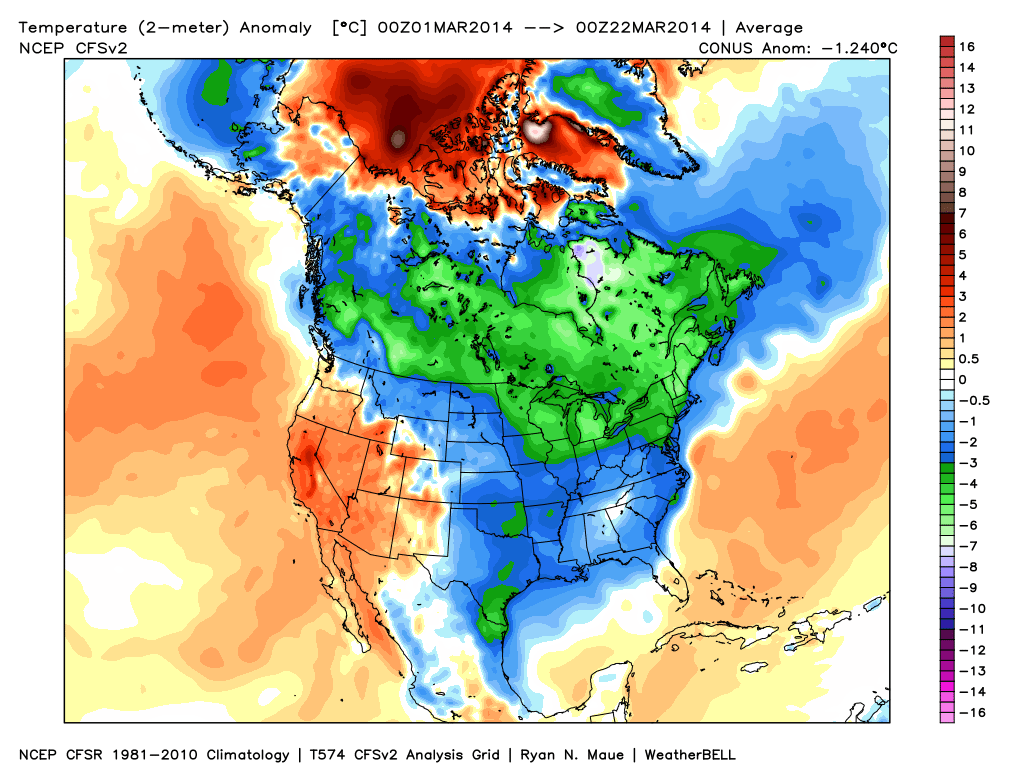
March has followed suite, month-to-date:  Cold continues for the majority of the upcoming week, but we note moderating late week temperatures.

1

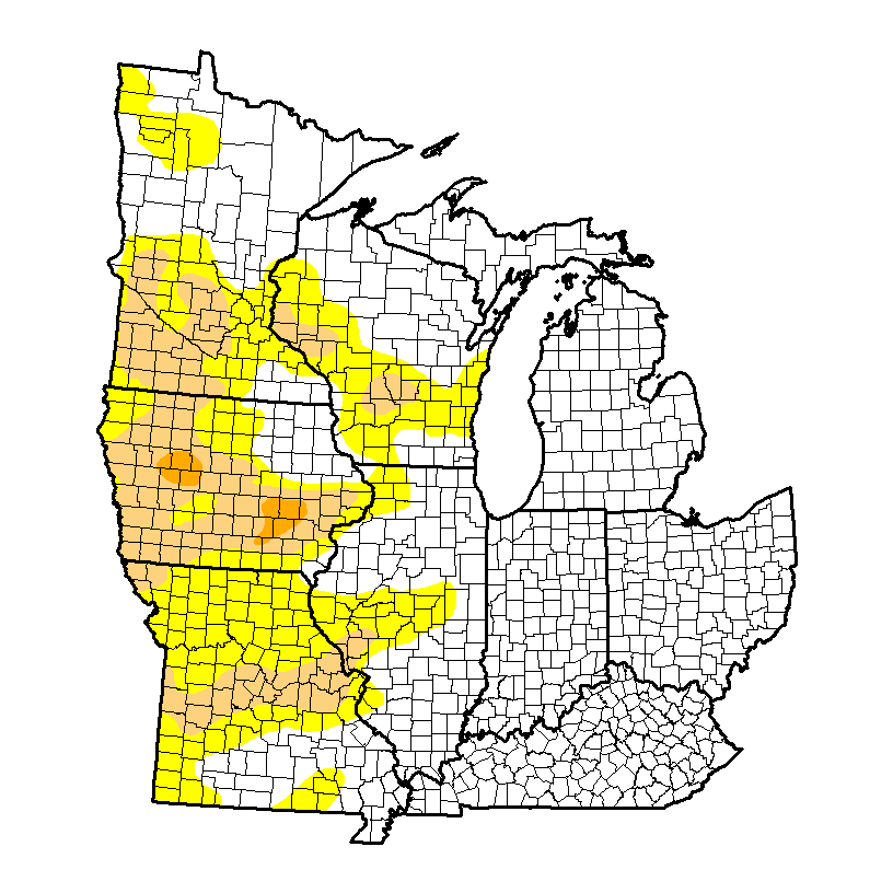
It’s been dry as of late, but after a snowy winter, the region is doing just fine from a drought perspective.  We note abnormally dry conditions west:

4

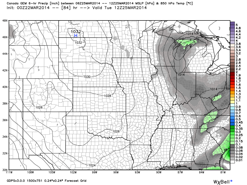
Latest CFSv2 data points to a wet spring ahead.  We also note the latest European weeklies suggesting a potentially “busy” 1st half of April, including a couple of “bowling ball” systems of note.  With the changing seasons, it’s not unusual to see big spring cut off lows slowly moving through portions of the country.

3

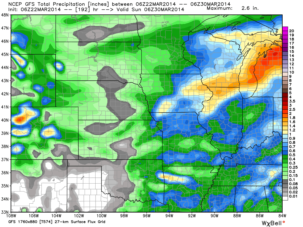
Note the GFS (7-day) and Canadian (10-day) precipitation forecast:

56

We also are still forecasting light snow Tuesday.  Most of this won’t accumulate with the high sun angle and low snowfall rates, but a brief coating to less than an inch is possible in spots:

78

Permanent link to this article: https://indywx.com/2014/03/22/where-weve-been-and-where-were-going/

Warmest Day Of The Period…

Fri.

Sat.

Sun.

Mon.

Tue.

Wed.

Thr.

 Status-weather-showers-day-icon

 Status-weather-showers-day-icon

 Status-weather-clouds-icon

 Status-weather-clouds-icon

 Status-weather-snow-scattered-icon

 Status-weather-clouds-icon

 Status-weather-clouds-icon

36/ 63

31/ 47

26/ 39

21/ 37

26/ 36

19/ 38

28/ 54

Light

Light

– – –

– – –

Light

– – –

– – –

Forecast Updated 03.21.14 @ 7:50a

Warm Front Passes. . .A warm front lifted north through the state during the wee morning hours. This sparked a couple light showers (snow burst across northern portions of the state), but wasn’t a big deal and a very nice Friday is on tap.  We’ll note a strong and gusty southwest breeze in play that will help send temperatures into the lower to middle 60s for afternoon highs along with partly cloudy skies.

Here Comes The Cold. . .Just as quick as the warm front passes a cold front will swing through the region and put an abrupt end to the spring tease.  Unfortunately, temperatures will slide the wrong direction over the weekend along with strong and gusty northwest winds.  This front may be accompanied by a couple light showers late tonight into early Saturday.

Tuesday Snow Maker. . .After a cold, but dry open to the work week, a disturbance will cross the Ohio Valley Tuesday and provide just enough moisture to combine with the cold air in place to result in the likelihood of light snow around these parts Tuesday.  We’re not thinking much in the way of accumulation will occur as overall snowfall rates will be relatively light, but we do note some localized light accumulations are possible. Otherwise, expect a mostly cloudy and “ridiculously” cold day.

Moderating. . .Indications are that we’ll begin to enjoy the return of southwest (milder) breezes in here by the end of next week.  As such, temperatures will begin to moderate and perhaps “inch” above the 50 degree mark by next Thursday.

Upcoming 7-Day Precipitation Forecast:

  • 7-Day Rainfall Forecast: 0.10″ – 0.25″
  • 7-Day Snowfall Forecast: Less than 1″

twicFor weather updates and more “behind the scenes” data on the go, be sure to Follow Us on Twitter @indywx or become a Friend of IndyWx.com on Facebook!

images

Permanent link to this article: https://indywx.com/2014/03/20/warmest-day-of-the-period/

Sunshine Returns!

Thr. Fri. Sat. Sun. Mon. Tue. Wed.               27/ 52 35/ 63 31/ 47 28/ 39 21/ 37 25/ 36 20/ 38 – –…

You must be logged in to view this content. Click Here to become a member of IndyWX.com for full access.  Already a member of IndyWx.com All-Access?  Log-in here.

Permanent link to this article: https://indywx.com/2014/03/20/sunshine-returns/

Video Update On The Next Couple Weeks!

Here’s a rather lengthy video taking a look at the weather here across central Indiana the next couple weeks. Oh yeah, we’re also a little excited about Coach Pearl coming…

You must be logged in to view this content. Click Here to become a member of IndyWX.com for full access.  Already a member of IndyWx.com All-Access?  Log-in here.

Permanent link to this article: https://indywx.com/2014/03/19/video-update-on-the-next-couple-weeks/

Busy Weather Week. . .

Tue.

Wed.

Thr.

Fri.

Sat.

Sun.

Mon.

 Status-weather-clouds-icon

 Status-weather-showers-day-icon

 Status-weather-clouds-icon

 Status-weather-showers-day-icon

 Status-weather-showers-day-icon

 Status-weather-clouds-icon

 images

28/ 55

37/ 49

29/ 53

40/ 62

31/ 46

22/ 35

21/ 40

– – –

Light

– – –

Light

Light

– – –

– – –

Forecast Updated 03.18.14 @ 7:57a

Nice Tuesday. . .Clouds hung tough Monday, but we finally got into sunshine during the afternoon which led to a very pleasant, albeit chilly, Monday evening.  Thankfully, the sunny close to Monday was a precursor to what we can expect Tuesday- mostly sunny to partly cloudy.  We’ll note a big improvement in the temperature department (after another cold start), courtesy of an increasingly strong south wind through the day.

Windy Wednesday. . .A cold front will race through the region Wednesday morning and will be accompanied by a band of showers and embedded thunder.  We think the majority of the rain falls during the predawn/ early morning hours Wednesday and most of the daylight hours will be dry, colder, and very windy.  A tightly wound low pressure system will roar through the Great Lakes region Wednesday and be responsible for producing strong and gusty winds, including gusts upwards of 40 MPH during the day Wednesday.

Thursday will be an “in between” day that will include dry skies and moderating temperatures.

Another Fast Moving Storm System. . .Yet another frontal boundary will blow through the region late Friday night and Saturday morning.  Before hand, a warm front will lift north through the region Friday morning and could help spark a scattered shower as it lifts north.  That said, most of the day will be dry and include an increasing south wind that will assist in shooting temperatures into the lower to middle 60s Friday afternoon.  Clouds will once again increase Friday night and lead to showers Friday night into Saturday morning.

Turning Colder Over The Weekend. . .A colder air mass will pour into the region for the upcoming weekend as north winds blow yet again.  This will send temperatures to well below normal levels.  In fact, temperatures will likely fall through the day Saturday, and Sunday will be another blustery, cold day.

As we look ahead to early next week, there will be a system that will warrant our attention for possible rain and/ or snow, but it’s far too early to be specific with this event.  Just know that we’ll keep our eye on things.  Regardless, conditions will be much colder than normal to put a wrap on March… Hang in there, spring has to arrive eventually, correct?

Upcoming 7-Day Precipitation Forecast

  • 7-Day Snowfall Forecast: 0.00″
  • 7-Day Rainfall Forecast: 0.25″-0.50″

twicFor weather updates and more “behind the scenes” data on the go, be sure to Follow Us on Twitter @indywx or become a Friend of IndyWx.com on Facebook!

images

Permanent link to this article: https://indywx.com/2014/03/17/busy-weather-week/

Changeable Weather This Week…

Mon.

Tue.

Wed.

Thr.

Fri.

Sat.

Sun.

 Status-weather-clouds-icon

 Status-weather-showers-day-icon

 Status-weather-clouds-icon

 Status-weather-clouds-icon

 Status-weather-showers-day-icon

 Status-weather-clouds-icon

 Status-weather-clouds-icon

19/ 43

30/ 56

35/ 50

30/ 51

42/ 65

30/ 45

22/ 37

– – –

Light

– – –

– – –

Light

– – –

– – –

Forecast Updated 03.17.14 @ 12:00p

Quiet, Brighter Start To The Work Week. . .After a “ridiculously” cold, windy, and gloomy Sunday, it’ll be nice to see the sunshine return as we kick off another work week.  Temperatures will remain much colder than average, but with that late March sun working through later this afternoon (once these pesky clouds move east), it’ll feel somewhat better.

Fast Moving Storm System. . .Most of Tuesday will be sunny and dry, but a frontal boundary will race towards central Indiana Tuesday evening and we note some of our high resolution model data trying to bring a thin line of showers and thunderstorms through in association with this frontal passage.  After a mainly dry day, clouds will increase and we’ll forecast quick-moving showers and embedded thunder Tuesday night into Wednesday morning.  Rainfall amounts will remain light.

Dry, blustery weather will return Wednesday afternoon with temperatures just a few degrees below normal.

Late Week Storm. . .After a dry and pleasant Thursday, southwest breezes will kick into high gear and allow temperatures to jump into the middle to perhaps upper 60s Friday (dependent upon how much sunshine we see).  That said, another cold front will have it’s eyes set on our area and clouds will increase during the afternoon and evening hours with showers and thunderstorms developing Friday night as the front pushes southeast.

This will then set the stage for another cold weekend ahead.  While we’re trending next weekend (especially Sunday) MUCH colder, it’s possible we’ll have to lower temperatures even further in the days ahead.

Upcoming 7-Day Precipitation Forecast:

  • 7-Day Snowfall Forecast: 0.00″
  • 7-Day Rainfall Forecast:  0.25″

twic

For weather updates and more “behind the scenes” data on the go, be sure to Follow Us on Twitter @indywx or become a Friend of IndyWx.com on Facebook!
images

After a long winter, sunshine and pleasant temperatures provided a great day to get outside and enjoy the conditions last Saturday in Zionsville!  Thanks to John Salewicz for this shot!

photo-2

Permanent link to this article: https://indywx.com/2014/03/16/changeable-weather-this-week/

Dry Today; Windy And MUCH Colder Sunday…

Sat.

Sun.

Mon.

Tue.

Wed.

Thr.

Fri.

 Status-weather-clouds-icon

 images

 Status-weather-clouds-icon

 Status-weather-showers-day-icon

 Status-weather-clouds-icon

 Status-weather-clouds-icon

 Status-weather-clouds-icon

32/ 52

24/ 30

17/ 42

27/ 54

39/ 50

32/ 53

33/ 62

– – –

– – –

– – –

Light

– – –

– – –

– – –

Forecast Updated: 03.15.14 @ 8:53a

Nice Today; MUCH Colder Sunday. . .Today will easily be the pick of the weekend as mostly sunny skies dominate along with seasonable temperatures.  Get outside and enjoy!

We continue to watch a southern storm system for the second half of the weekend and while model data trended north Thursday, the common theme most of Friday into this morning has been back south.  As such, we’ll lean towards a less snowy forecast Sunday for central Indiana, but note if you have travel plans to the southern third of the state that accumulating snow and ice will greet you Sunday.  Here across central Indiana look for a rather cloudy and MUCH colder day.  In fact, temperatures won’t even make it to the freezing mark with a very strong east to northeast wind in play.  Winds may gust as high as 35 MPH Sunday afternoon, making it feel like the single digits and teens.

Relatively Quiet Week. . .Modeling continues to struggle with the timing and strength of storm systems in the week ahead, but current thinking takes the storm track primarily north of our area next week, meaning less impact (from rain or snow chances) here.  We caution that this can change and we’ll keep a close eye on things, but we’re trending our forecast towards a quieter one for now.  The next system of note will be a fast moving low pressure area and associated cold front that will pass here Tuesday into Wednesday.  A scattered shower and wind shift will occur with this system, but, as stated above, the majority of the more significant “weather” will lie to our north.

A brief warming trend to well above normal temperatures may carry us to close out the work week before the next systems eyes our area later next weekend.

Upcoming 7-Day Precipitation Forecast

  • 7-Day Snowfall Forecast: 0.00″
  • 7-Day Rainfall Forecast: 0.25″

twic

For weather updates and more “behind the scenes” data on the go, be sure to Follow Us on Twitter @indywx or become a Friend of IndyWx.com on Facebook!
images

I know many are saying thankfully we aren’t dealing with this kind of weather today.  After a harsh winter, it’s always nice to see the sunshine and milder temperatures return.  Today we take you back to a snowy Zionsville from February 17th.  This shot was taken by Janet Baker.  Thanks, Janet!

SnowFeb17Zionsville

Permanent link to this article: https://indywx.com/2014/03/15/dry-today-windy-and-much-colder-sunday/

IndyWx.com