Category: Forecast Discussion

Feeling Like Summer!

Tue.

Wed.

Thr.

Fri.

Sat.

Sun.

Mon.

 Status-weather-showers-day-icon

 Status-weather-showers-day-icon

 Status-weather-showers-day-icon

 Status-weather-clouds-icon

 Status-weather-clouds-icon

 Status-weather-clouds-icon

 Status-weather-showers-day-icon

65/ 83

64/ 80

66/ 80

55/ 78

55/ 79

56/ 82

63/ 83 

Light

Light

Light

– – –

– – –

– – –

Light

After a long holiday weekend featuring ideal weather conditions, we’ll see rain and storm chances increase through mid week.  Everyone won’t get wet today (coverage will be limited to roughly 30% of the central Indiana viewing area), but numerous showers and thunderstorms will be around Wednesday and Thursday.  Locally heavy downpours will be possible under any storm with the humid air mass in place.  Yet again, we’ll get a push of drier, less humid air just in time for the weekend so we anticipate Friday through Sunday to be another very nice weather stretch here across central Indiana (talk about perfect timing). There are some hints next week could be quite wet around these parts and we’ll begin to ramp rain chances back up as early as Monday.

Permanent link to this article: https://indywx.com/2014/05/27/feeling-like-summer/

Indy Weather Recap And A Look Ahead

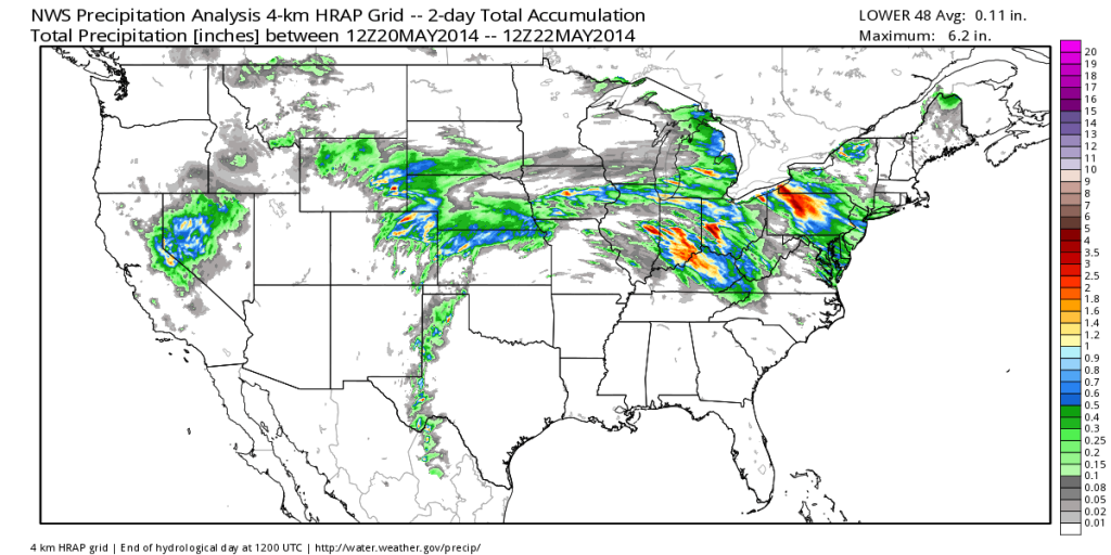
Wednesday was a stormy day across central Indiana, including damaging wind and hail. Flooding was also a concern in some areas.  Officially here at IndyWx.com HQ we picked up 2.21″ of rain Wednesday- most of which fell in a 3 hour time period.  Here’s a cool image from the fine folks at Weatherbell Analytics showcasing the heaviest rainfall.

nws_precip_conus2_2

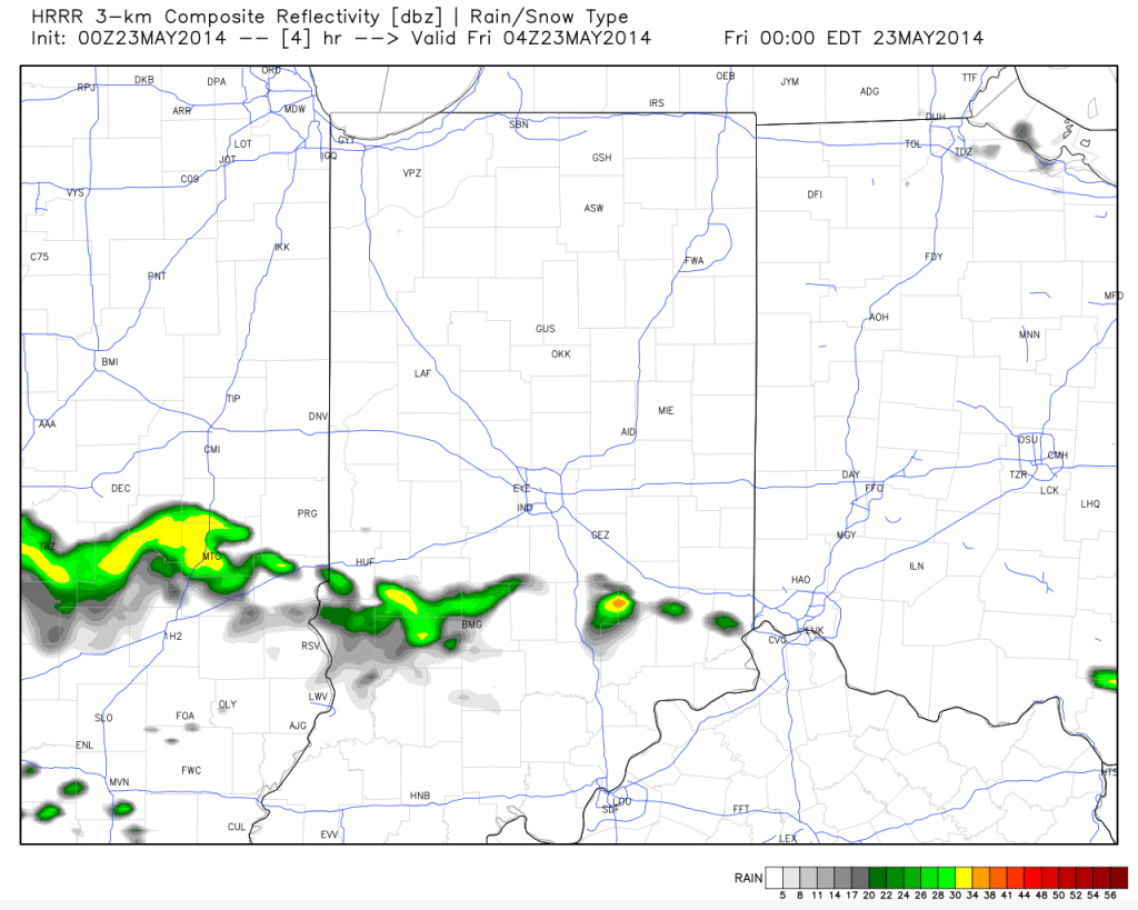
Despite a couple of showers (primarily south of the city) later this evening the upcoming three days will be beautiful and rain-free!

hrrr_ref_indy_5

Temperatures are trending cooler when compared to 24 hours ago and as noted here by the 24 temperature difference, the cooler air to our north will continue to push south tonight.

t0

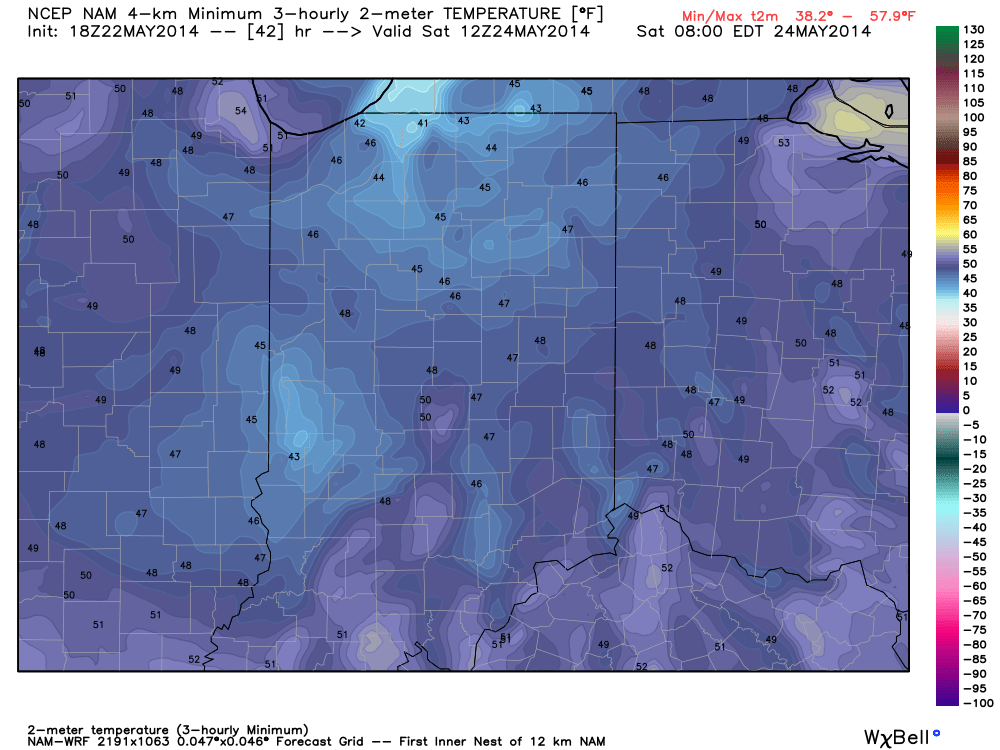
Temperatures and humidity levels will be below normal levels the next couple days before warmth slowly builds Sunday.  Lows Saturday morning will dip into the upper 40s for several communities.

hires_t2m_min_indy_14

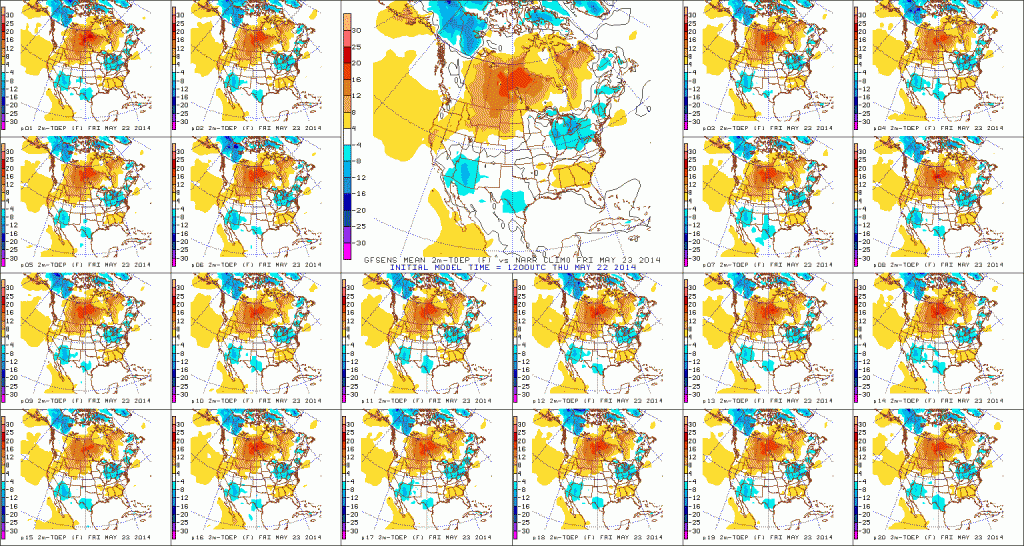
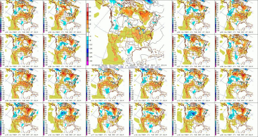
True summer-like heat and humidity will lift north Memorial Day into Tuesday.  Note the temperature anomalies do an about face from Day 1 to Day 5.  Heat and humidity will be on the rebound for the unofficial start to summer, but, as noted above, should remain in the “comfy range” for race day.

D1

D5

With the increasing warmth and humidity will come a return of scattered shower and thunderstorm chances early next week.

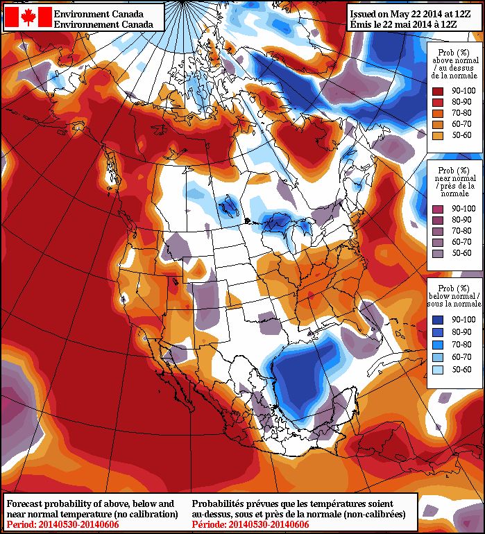
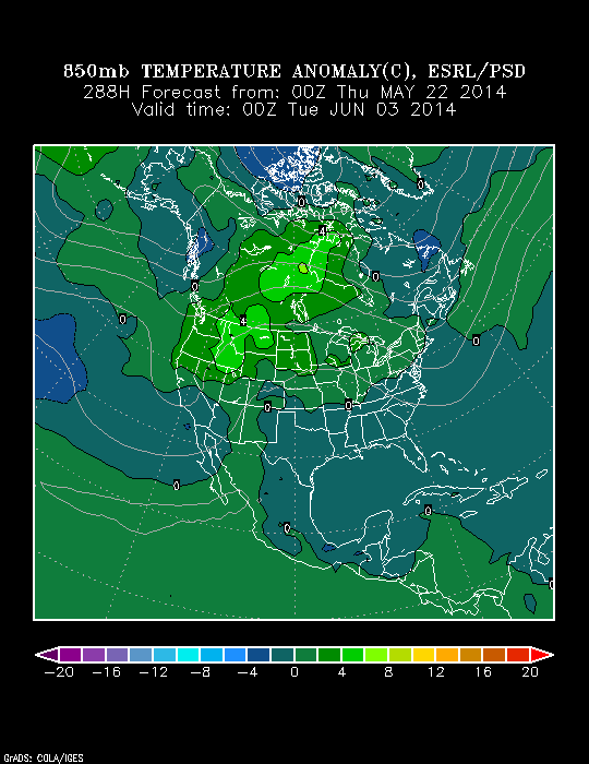
As we look forward to early June, there are indications it could open on the warm side.  Note relative agreement between the CFSv2 (Climate Forecast System version 2), NAEFS, and Physical Science Division model.  Does the warm pattern stick and hold?  Not so fast, my friend… 😉

2014052212_054@007_E1_north@america_I_NAEFS@TEMPERATURE_anomaly@probability@combined@week2_186wk1.wk2_20140521.NAsfcTt850_anom_f288_ussm

Permanent link to this article: https://indywx.com/2014/05/22/indy-weather-recap-and-a-look-ahead/

Fantastic Weather Heading Into The Holiday Weekend!

Thr.

Fri.

Sat.

Sun.

Mon.

Tue.

Wed.

 Status-weather-clear-icon

 Status-weather-clear-icon

 Status-weather-clear-icon

 Status-weather-clouds-icon

 Status-weather-showers-day-icon

 Status-weather-showers-day-icon

 Status-weather-showers-day-icon

58/ 74

52/ 70

48/ 74

53/ 79

60/ 84

65/ 86

68/ 83 

– – –

– – –

– – –

– – –

Light

Light

Light

After a stormy Wednesday that featured flooding, hail, and wind damage, today will be a refreshing change!  The cooler, drier, and sunny start to the day is a sign of things to come for the long holiday and race weekend!  A weak disturbance could add a few clouds tonight and a shower downstate, but most will stay dry.  High pressure will then supply wall-to-wall sunshine and cooler air as we wrap up the work week and head into the long weekend.  A hotter, more humid air mass will build in for Memorial Day, itself, and result in a muggy feel along with scattered showers and thunderstorms early next week.

Permanent link to this article: https://indywx.com/2014/05/22/fantastic-weather-heading-into-the-holiday-weekend/

Severe Weather Video Brief Tonight-Wednesday

The region remains under fire for severe weather potential, primarily for damaging straight line wind and hail per latest thinking.  The video uncovers when you can expect this and looks ahead to the all-important Memorial Day and Indianapolis 500 weekend!

The region is under fire for severe potential Wednesday.

The region is under fire for severe potential Wednesday.

Permanent link to this article: https://indywx.com/2014/05/20/severe-weather-video-brief-tonight-wednesday/

Eyeing Storms Wednesday; Beauty Of A Weekend On Deck!

Tue. Wed. Thr. Fri. Sat. Sun. Mon.               57/ 80 64/ 80 58/ 74 51/ 72 49/ 74 52/ 78 61/ 84  Light Light…

You must be logged in to view this content. Click Here to become a member of IndyWX.com for full access.  Already a member of IndyWx.com All-Access?  Log-in here.

Permanent link to this article: https://indywx.com/2014/05/20/eyeing-storms-wednesday-beauty-of-a-weekend-on-deck/

Catching Up On A Monday Morning!

Happy Monday!  Here’s hoping everyone had a great weekend!  The week ahead will feature a much warmer, muggier regime as early as Tuesday.  Rain chances will increase Wednesday night into Thursday (early indications are for around half an inch of rain).  We’ll then (thankfully) dry things out and introduce a very pleasant air mass heading into the all-important Memorial Day and Race weekend.  We’ll have a full 7-day forecast posted here later this evening.  Make it a great Monday!

Southerly winds will transport 80 degree type air and a more humid feel by Tuesday and Wednesday.

Southerly winds will transport 80 degree type air and a more humid feel by Tuesday and Wednesday.


A cold front will deliver best rain chances of the week Wednesday night into Thursday.

A cold front will deliver best rain chances of the week Wednesday night into Thursday.


Permanent link to this article: https://indywx.com/2014/05/19/catching-up-on-a-monday-morning/

Slow Improvements…

Sat.

Sun.

Mon.

Tue.

Wed.

Thr.

Fri.

 Status-weather-showers-day-icon

 Status-weather-clouds-icon

 Status-weather-clouds-icon

 Status-weather-showers-day-icon

 Status-weather-showers-day-icon

 Status-weather-showers-day-icon

 Status-weather-showers-day-icon

40/ 57

38/ 64

43/ 68

55/ 78

65/ 81

62/ 76

53/ 73 

Light

– – –

– – –

Light

Light

Light

Light

“Improvement” will be the weather word of the weekend, but it’s going to take a couple of slow baby steps before we see full-blown improvement (we think that comes Sunday)!  Today will feature more sunshine than Friday, but with plenty of cold air aloft, it won’t take long for that May sun to do it’s dirty work and help showers bubble up this afternoon.  While some small hail will be possible with the showers, hail reports won’t be nearly as widespread as what we saw Friday.  Temperatures will remain well below normal.  We finally think we can shake shower chances Sunday and introduce a partly cloudy sky.  Early next week looks dry, as well, until a warm front lifts north Tuesday.  This will introduce a much warmer, muggy brand of air to central Indiana and allow for the chance of scattered showers and thunderstorms for mid and late week.  A weak frontal boundary will slip south Thursday into Friday which will knock temperatures back a few degrees to wrap up the work week.  Rainfall amounts through the period will remain rather light, but some local downpours are possible in the muggy air mass mid week.

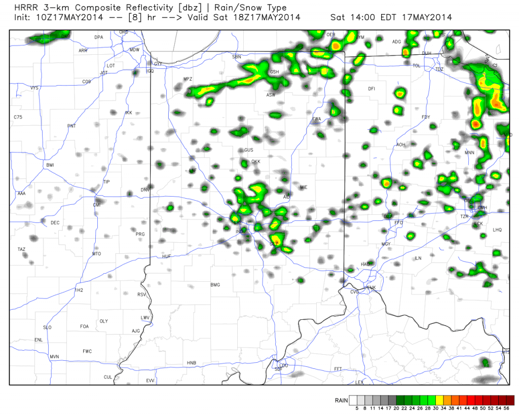
Forecast radar valid at 2p today shows scattered showers developing.

Forecast radar valid at 2p today shows scattered showers developing.

Permanent link to this article: https://indywx.com/2014/05/17/slow-improvements/

Thursday Evening Update; Repeat In The Pattern Coming To End May?

Many central Indiana neighborhoods are still in the 40s as of this update.  Officially, the high so far today at IND has reached 50 and is more than 20 degrees below where we should be for this date.

The upper low continues to swirl over Iowa this afternoon and will help push a band of showers into central Indiana during the wee morning hours Friday.  Additionally, the threat is there that a couple of the stronger showers Friday afternoon include some small hail with added instability and the very cold air aloft.

20140515_2045_sm_EVV_vis


As we look ahead to the second half of May, don’t be surprised by a repeat performance in this weather pattern.  We think brief ridging will be responsible for highs above the 80 degree mark the middle of next week, but the stage may be set for another stretch of unseasonably cool air to wrap up the month…. Additional details can be found in the video!

Permanent link to this article: https://indywx.com/2014/05/15/thursday-evening-update-repeat-in-the-pattern-coming-to-end-may/

Raw And Chilly!

Thr.

Fri.

Sat.

Sun.

Mon.

Tue.

Wed.

 Status-weather-showers-scattered-icon

 Status-weather-showers-scattered-icon

 Status-weather-showers-day-icon

 Status-weather-clouds-icon

 Status-weather-clouds-icon

 Status-weather-showers-day-icon

 Status-weather-clouds-icon

42/ 51

38/ 52

36/ 58

37/ 63

41/ 67

52/ 70

60/ 80 

Light

Light

Light

– – –

– – –

Light

– – –

We’re locked into a cloudy, raw, and wet weather pattern and there’s no let up until later into the upcoming weekend.  A big upper low is positioned across Iowa this morning and will remain the primary driver in our weather here through Saturday.  Unseasonably chilly conditions, gusty northwest winds, and periods of drizzle and rain can be expected through the period.  We’ll finally begin to shake the clouds and rain, but unseasonably cool air will linger into early next week.  As for the pick of the weekend, it still easily appears to be Sunday, with mostly dry conditions, increased sunshine, and moderating temperatures.  An additional one half to three quarters of an inch of rain will be possible between today and Saturday.  Warmer times are ahead early next week as a warm front blows through the area with a possible shower or storm Tuesday.

Permanent link to this article: https://indywx.com/2014/05/15/raw-and-chilly/

Promised Wet, Chilly Pattern Here

The remainder of the work week will feature plenty of rain and well below normal temperatures.

A surface wave will move up along a cold front today into Thursday and be responsible for widespread rain, some of which will be heavy, across central Indiana.  Additionally, severe thunderstorms, including possible quick spin-up tornadoes, will be possible across far eastern Indiana and Ohio this afternoon and evening.

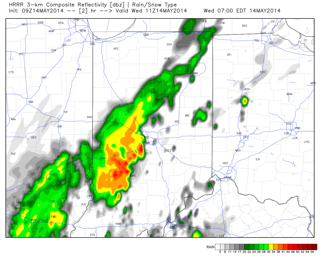
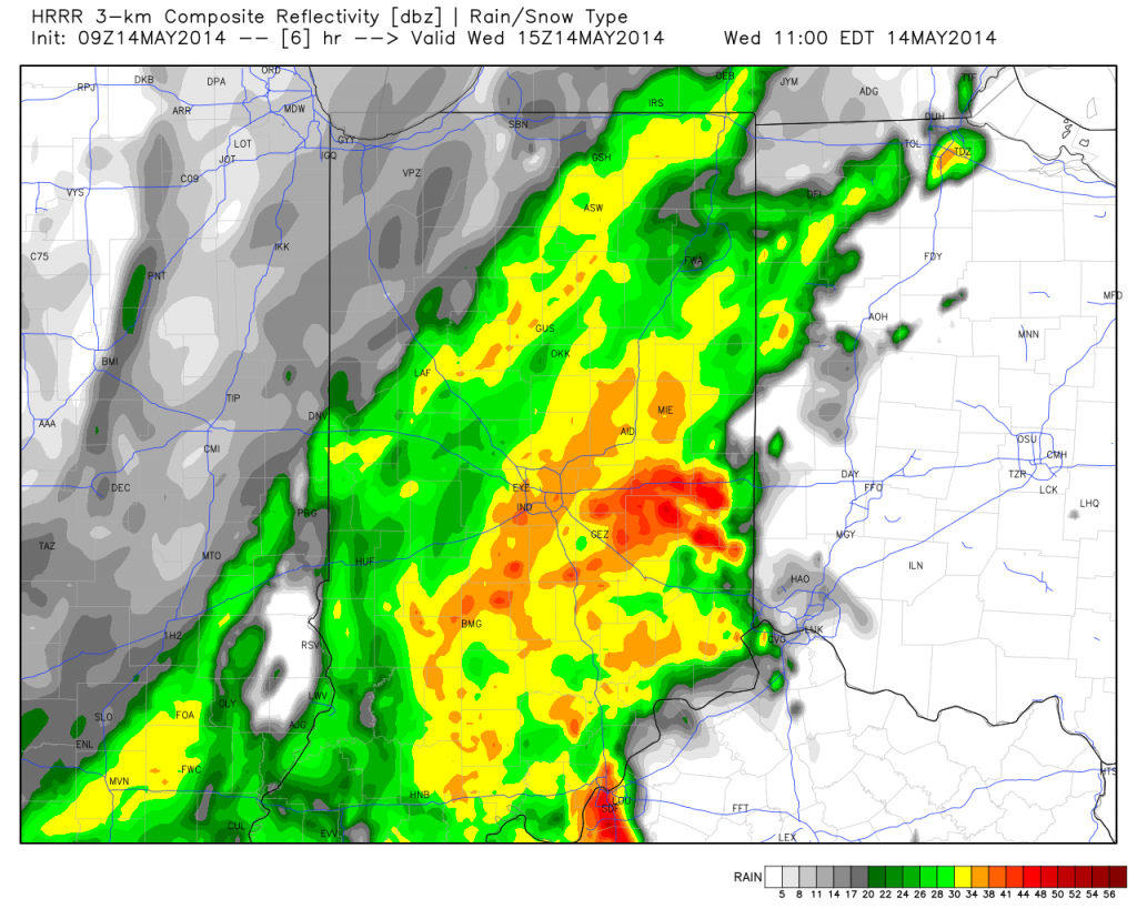
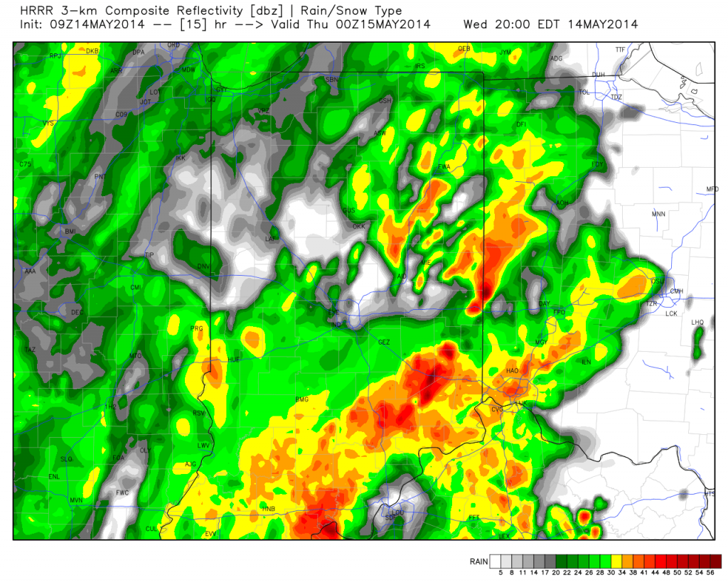
Note the forecast radar stays rather busy in the hours ahead!

hrrr_ref_indy_3

hrrr_ref_indy_7hrrr_ref_indy_16

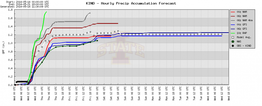
Area additional rainfall total will reach between 1-2″ between this morning and Friday afternoon.

hires_t_precip_indy_20plotter

The other big story is the chill.  Temperatures are drastically cooler this morning than what we’ve gotten used to the past several days, and the step down process will continue.  We still think most of Thursday is spent in the 40s.

hires_t2m_max_indy_13

Permanent link to this article: https://indywx.com/2014/05/14/promised-wet-chilly-pattern-here/

IndyWx.com