Category: Forecast Discussion

Storm Chances Remain Before We Turn Much Cooler…

Sun.

Mon.

Tue.

Wed.

Thr.

Independence Day

Sat.

 Status-weather-showers-day-icon

 Status-weather-showers-day-icon

 Status-weather-showers-day-icon

 Status-weather-showers-day-icon

 Status-weather-clouds-icon

 Status-weather-clouds-icon

 Status-weather-clouds-icon

70/ 83

72/ 88

72/ 85

63/ 78

59/ 74

51/ 77

54/ 82 

Light

Light

Light

Light

– – –

– – –

– – –

Most of today will be dry and though we’ll be continued warm and humid, we’ll have just enough breeze to make it feel comfortable out.  Better rain chances will remain down state late morning into the afternoon.  While a scattered shower or storm is possible across central Indiana, most will remain rain-free today we think.  We’re going to have to monitor a couple of complexes of strong to severe thunderstorms late tonight and again Monday night off to our northwest.  Short-term modeling keeps both complexes just to our north, but we’ll keep a close eye on things moving forward.  Rain chances remain through mid week before a big push of cooler, drier air blows into town for the long holiday weekend.  Temperatures will run much cooler than average and provide a taste of early fall during what traditionally is the dog days of summer!

Permanent link to this article: https://indywx.com/2014/06/29/storm-chances-remain-before-we-turn-much-cooler/

Humid Weekend; Severe Potential Monday.

Sat.

Sun.

Mon.

Tue.

Wed.

Thr.

Independence Day

 Status-weather-showers-day-icon

 Status-weather-showers-day-icon

 Status-weather-storm-night-icon

 Status-weather-showers-day-icon

 Status-weather-clouds-icon

 Status-weather-clouds-icon

 Status-weather-clouds-icon

69/ 83

70/ 83

71/ 88

70/ 84

60/ 75

56/ 76

53/ 80 

Light

Light

Light

Light

– – –

– – –

– – –

A warm front is lifting north through the region this morning and rain will continue to expand in coverage this morning as the front lifts north.  Sunshine will then quickly build back into central Indiana this afternoon, along with plenty of humidity.  We’ll get back into the scattered afternoon/ evening “splash and dash” thunderstorm regime later today and again Sunday.  Looking further ahead, concern is growing about a potential severe weather event here Monday and we’ll have an additional post later this weekend discussing this potential in more detail.  For now, plan to pay special close attention to Monday’s forecast with damaging severe weather potential in play (all modes of severe weather at hand).  We still forecast a MUCH cooler, drier regime building in mid week and remaining in place through the upcoming holiday weekend.

Permanent link to this article: https://indywx.com/2014/06/28/humid-weekend-severe-potential-monday/

Quick Friday Evening Video Update

Seems like a broken record, but more showers and thunderstorms dot the central Indiana landscape this evening and will continue over the weekend, though no all day rains are anticipated.  Additionally, we’re still tracking well below normal air for the all-important holiday weekend next week.  Details in a quick Friday evening video update below!

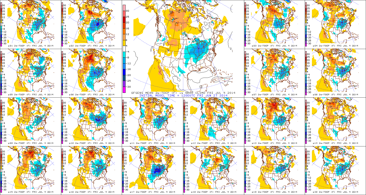
A cooler than average pattern continues to look likely for the all-important July 4th weekend.

A cooler than average pattern continues to look likely for the all-important July 4th weekend.

Permanent link to this article: https://indywx.com/2014/06/27/quick-friday-evening-video-update/

“Summery” Weekend, But Eyeing A Cool 4th!

Fri. Sat. Sun. Mon. Tue. Wed. Thr.               65/ 85 69/ 82 69/ 85 71/ 87 72/ 85 63/ 81 54/ 75  Light Light…

You must be logged in to view this content. Click Here to become a member of IndyWX.com for full access.  Already a member of IndyWx.com All-Access?  Log-in here.

Permanent link to this article: https://indywx.com/2014/06/27/summery-weekend-but-eyeing-a-cool-4th/

Thursday Evening Weather Rambles…

1.) After a relatively dry day (though don’t tell Indy’s northwest communities that) Thursday, rain chances will begin to creep back into our forecast over the weekend as humidity levels…

You must be logged in to view this content. Click Here to become a member of IndyWX.com for full access.  Already a member of IndyWx.com All-Access?  Log-in here.

Permanent link to this article: https://indywx.com/2014/06/26/thursday-evening-weather-rambles/

Nice Day Shaping Up!

Thr. Fri. Sat. Sun. Mon. Tue. Wed.               65/ 83 64/ 85 67/ 86 71/ 87 73/ 90 73/ 89 64/ 79  – –…

You must be logged in to view this content. Click Here to become a member of IndyWX.com for full access.  Already a member of IndyWx.com All-Access?  Log-in here.

Permanent link to this article: https://indywx.com/2014/06/26/nice-day-shaping-up/

Overall Drier, But Rain Chances Remain…

Wed. Thr. Fri. Sat. Sun. Mon. Tue.               65/ 83 61/ 83 63/ 85 68/ 86 69/ 88 71/ 89 71/ 90  Light –…

You must be logged in to view this content. Click Here to become a member of IndyWX.com for full access.  Already a member of IndyWx.com All-Access?  Log-in here.

Permanent link to this article: https://indywx.com/2014/06/25/overall-drier-but-rain-chances-remain/

Hot Weekend Coming, But We’re Set To Cool Going Into The Holiday…

The pattern continues to look as if it’ll evolve in a way that will assist in delivering the hottest air so far this year during the course of the upcoming weekend into early next week.  That said, the seeds are once again being planted that should promote a trough and associated cooler than normal pattern returning as we head closer to the Independence Day holiday.

In short, an active and progressive pattern is set to continue across our immediate neck of the woods.  This promises a continuation of above average precipitation and while shots of hot air will invade from time to time, it’s going to be mighty tough to get any sort of hot pattern to stick around for any sort of staying power over the course of the upcoming couple weeks.

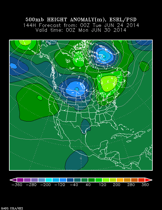
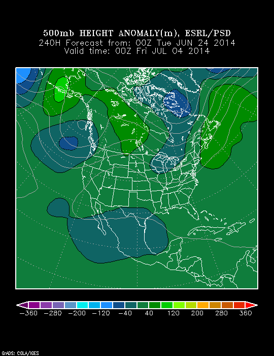
In the short-term, we’ll enjoy a couple of cooler, drier days for the mid week stretch, but ridging will build this weekend into the middle part of next week and we should have no problem reaching the hottest levels of the year so far.  Note, however, how the upper pattern reverses and allows a trough to develop over the Lakes and Ohio Valley by Day 10, or the Independence Day holiday.

z500_anom_f144_ussm

z500_anom_f240_ussm


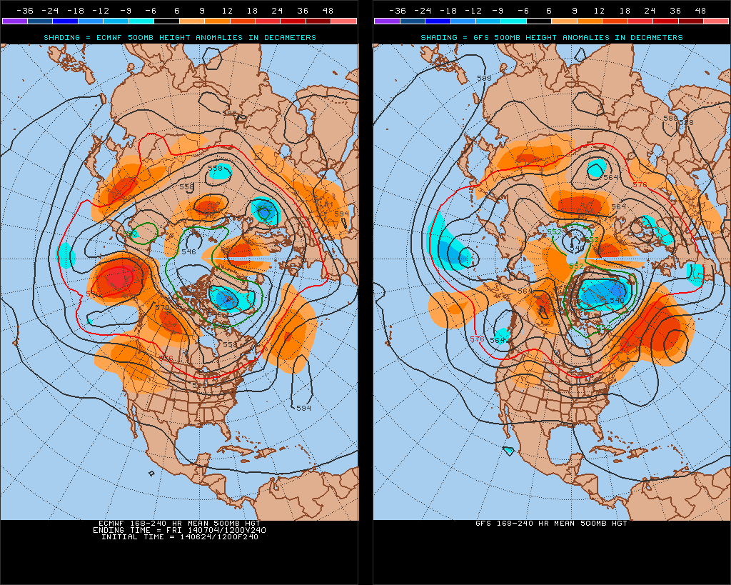
There’s relatively good agreement between the GFS and European during the 8-10 day period with the trough and associated cooler pattern returning.

test8

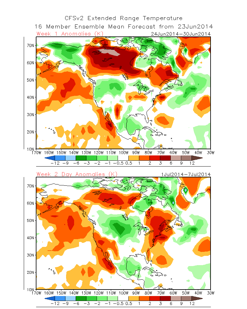
The NAEFS and CFSv2 highlight the warmer than normal pattern giving way to cooling week 2.

2014062412_054@007_E1_north@america_I_NAEFS@TEMPERATURE_anomaly@probability@combined@week2_186


wk1.wk2_20140623.NAsfcT


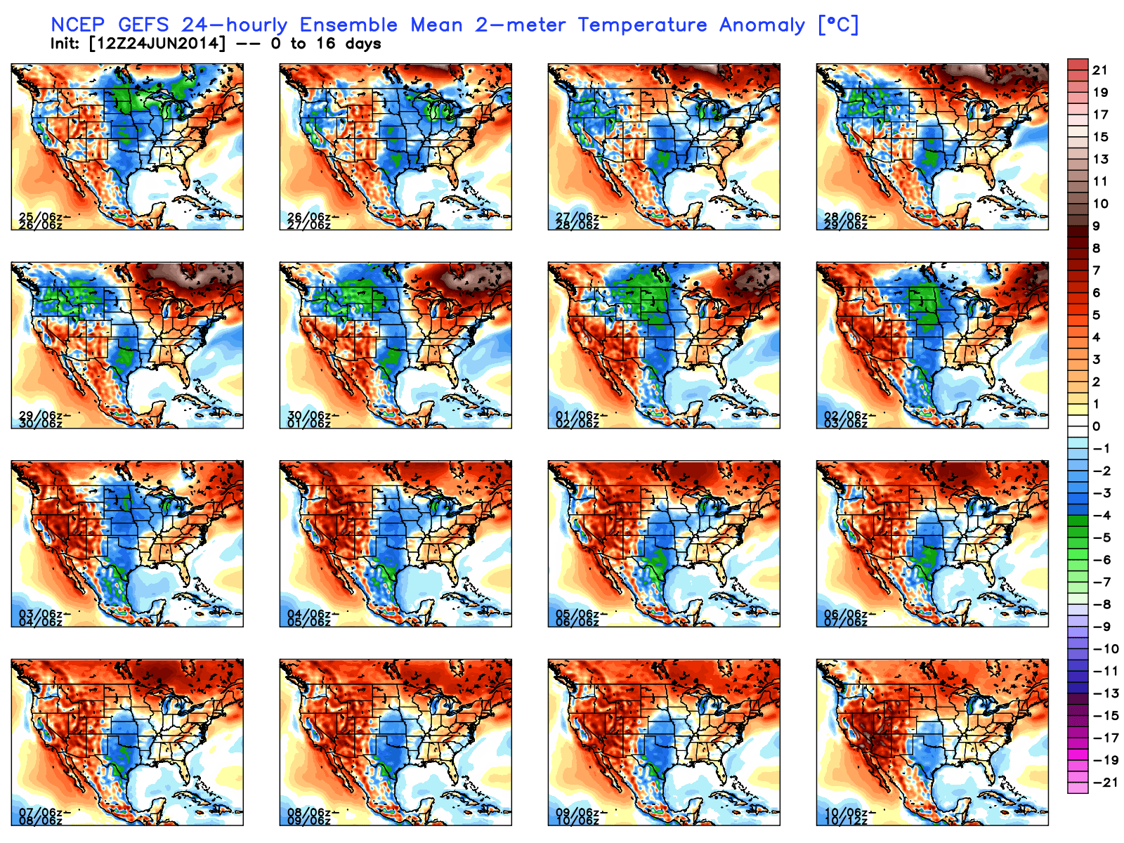
The GFS ensembles show the transient regime ahead.  Note the warming giving way to cooling and then warming again towards week 3.  Again, this is a good indication of wetter than normal conditions as well across a good portion of the Mid West and Ohio Valley.

gefs_t2anom_16_conus_1

To sum things up, the hottest air so far this year will likely move into the Hoosier state early next week and feature a day or two of 90 degrees +.  The heat won’t have staying power as a trough and associated cooler air mass will return heading into the Independence Day holiday, and could potentially be highlighted by a round of gusty storms as the heat gives way to cooling.  We’ll have to keep an eye on this as we draw closer.

Permanent link to this article: https://indywx.com/2014/06/24/hot-weekend-coming-but-were-set-to-cool-going-into-the-holiday/

Showers, Thunderstorms Expand In Coverage Later Today.

We’re eyeing a rather unsettled day across central Indiana, including numerous showers and thunderstorms that will likely develop across the region, especially from late morning into the evening hours.  So far, the majority of heavy rain and thunderstorms has remained off to our northwest, but that will likely change within the next few hours.

We’re tracking upper level energy off to our southwest this morning and this piece of energy will track northeast as we move through the second half of the day.

nam_z500_uv_vort_mc_4

The latest visible satellite image also shows the spin associated with the upper level energy over southern Illinois this morning.

20140624_1300_LIT_vis

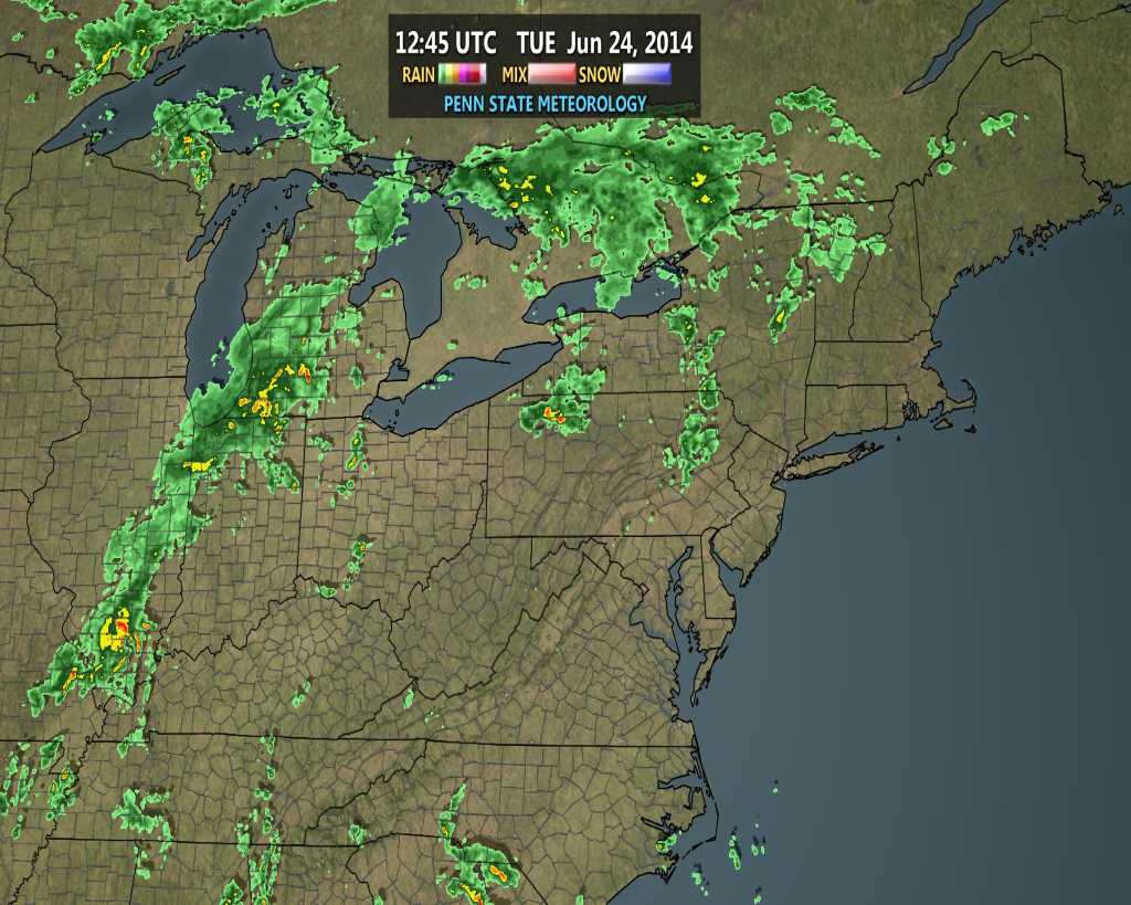
Note the heavy rain and embedded thunder currently to our southwest associated with this disturbance this morning.

nerad24

As this energy moves northeast there’s no reason to think widespread showers and thunderstorms won’t be around the region this afternoon and evening.  We note a very humid air mass in place with dew points around 70.  Furthermore, precipitable water (PWAT) will approach 2″ this afternoon across the area.  The upper energy will provide the needed lift.  Needless to say, the ingredients are in place for another round of heavy rain.

The HRRR simulated radar product has a pretty good handle on what the radar may look like this afternoon, valid at 3p.

hrrr_ref_indy_9

Widespread rainfall totals should fall within the 0.50″-1.00″ range on average today, but locally heavier totals closer to 2″ will certainly be possible under the heavier storms.

Interested in personal weather forecasts or consulting for yourself or place of business?  Email us at bill@indywx.com.

Permanent link to this article: https://indywx.com/2014/06/24/showers-thunderstorms-expand-in-coverage-later-today/

Splash And Dash Storms To Open The Work Week…

Mon. Tue. Wed. Thr. Fri. Sat. Sun.               68/ 88 69/ 81 66/ 82 61/ 84 65/ 83 68/ 84 70/ 87  Light Light…

You must be logged in to view this content. Click Here to become a member of IndyWX.com for full access.  Already a member of IndyWx.com All-Access?  Log-in here.

Permanent link to this article: https://indywx.com/2014/06/23/splash-and-dash-storms-to-open-the-work-week/

IndyWx.com