Category: Forecast Discussion

Light Showers To Begin The Week Otherwise Cool And Dry…

Mon.

Tue.

Wed.

Thr.

Fri.

Sat.

Sun.

 Status-weather-showers-day-icon

 Status-weather-showers-day-icon

 Status-weather-clouds-icon

 Status-weather-clouds-icon

 Status-weather-clouds-icon

 Status-weather-clouds-icon

 Status-weather-clouds-icon

44/ 62

42/ 54

37/ 56

37/ 59

45/ 65

48/ 69

49/ 73 

Reinforcing Cool Air…After a cool weekend, a reinforcing shot of unseasonably chilly air will move into the region later this evening.  A couple sprinkles or light showers are possible both today and Tuesday, but rainfall amounts will remain light for those that do see a shower.  The bigger story will be the cool air as highs Tuesday only top out in the lower to middle 50s.  Patchy frost is possible Wednesday and Thursday mornings as skies clear and lows dip into the 30s.

Extended Stretch Of Dry Weather…High pressure will supply lots of sunshine and an extended stretch of dry weather Tuesday night through the weekend.  Additionally, after an unseasonably chill start to the period, temperatures will moderate, reaching above normal levels over the weekend.  All-in-all, a very pleasant weekend appears to be waiting on deck.

Upcoming 7-Day Precipitation Forecast:

  • 7-Day Rainfall Forecast: 0.10″
  • 7-Day Snowfall Forecast: 0.00″

Interested in private weather consulting?  E-mail us at bill@indywx.com.

This was the peak weekend for fall foliage across many central Indiana communities.  Lots of vibrant colors remain and with an overall dry, cool week upcoming we should be able to hold onto that color for a while longer.  John Salewicz sent in this beautiful photo taken in Zionsville over the weekend showcasing the color.  Thanks, John!

B0Qz6ARCUAAB8NB

Permanent link to this article: https://indywx.com/2014/10/20/2848/

Getting To Be That Time Of Year…

A couple opportunities of frost and freeze conditions will be served up to central Indiana communities in the upcoming week. Reinforcing shots of chilly air will invade the region with…

You must be logged in to view this content. Click Here to become a member of IndyWX.com for full access.  Already a member of IndyWx.com All-Access?  Log-in here.

Permanent link to this article: https://indywx.com/2014/10/16/getting-to-be-that-time-of-year/

Much Needed Dry Time On Deck For #Harvest14…

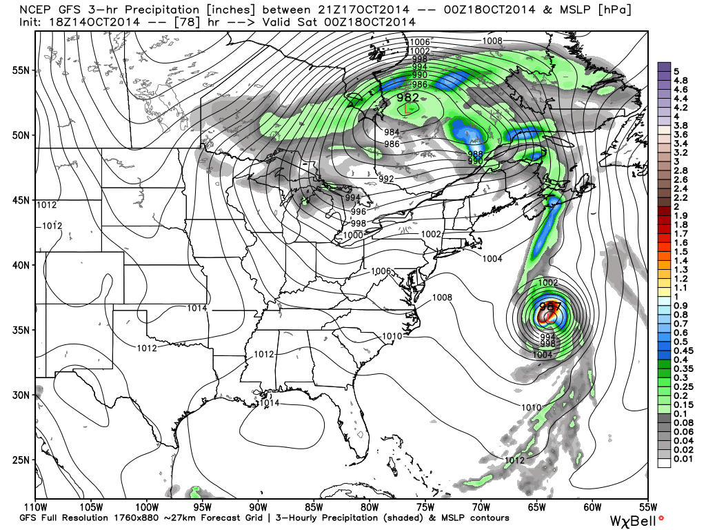
Despite another day of showery, damp weather Wednesday, the overall “trend is our friend” in the short to mid range as a much drier pattern develops.

Drier, cooler air will penetrate into the Mid West and Ohio Valley as the weekend draws closer.

gfs_precip_mslp_east_19


gfs_precip_mslp_east_27


gfs_precip_mslp_east_43


It’s important to note the GFS has support on the drier trend to include some other highly respected mid range model suites such as the Canadian and European.

The next round of rain arrives Tuesday with reinforcing chilly air that could deliver mid and late week frost and freeze conditions for parts of the region.  The Canadian is a little more bullish on rainfall totals when stacked against the GFS and European.  We’ll continue to monitor.

gfs_precip_mslp_east_51


cmc_precip_mslp_east_26


Regardless of Tuesday rain, we’ll quickly return to a dry regime by the middle of next week.

The Climate Prediction Center (CPC) agrees on a drier pattern in the mid range.

814prcp.new


Latest forecast rainfall totals off the GFS model suggest amounts of 0.50″, or less, across the region over the upcoming 7-days, and it’s important to note half of that likely falls Wednesday with showers associated with swirling low pressure around the region.

gfs_total_precip_east_30


Note the cooler trend developing in the 7-day, as well:

KIND_2014101418_tx_192

If your company depends on snow removal or other types of winter weather, please send us an e-mail for customized winter weather consulting at bill@indywx.com.

Permanent link to this article: https://indywx.com/2014/10/14/much-needed-dry-time-on-deck-for-harvest14/

Tuesday Morning Rambles: Rain, Dry Time, And Frost?!

More rain is in the forecast today and Wednesday as a big, slow moving autumn storm system takes its time moving through the region. Additional rain the next 36 hours…

You must be logged in to view this content. Click Here to become a member of IndyWX.com for full access.  Already a member of IndyWx.com All-Access?  Log-in here.

Permanent link to this article: https://indywx.com/2014/10/14/tuesday-morning-rambles-rain-dry-time-and-frost/

Stormy Times Today; Severe Weather Tonight…

It’s a wet and stormy start for many this morning. Despite some local downpours and embedded thunder, all of this morning’s storms will remain below severe levels. Periods of showers…

You must be logged in to view this content. Click Here to become a member of IndyWX.com for full access.  Already a member of IndyWx.com All-Access?  Log-in here.

Permanent link to this article: https://indywx.com/2014/10/13/stormy-times-today-severe-weather-tonight/

Cool Autumn Weekend; Severe Storm Potential Monday Night…

Sat.

Sun.

Mon.

Tue.

Wed.

Thr.

Fri.

 Status-weather-clouds-icon

 Status-weather-showers-day-icon

 Status-weather-storm-night-icon

 Status-weather-showers-scattered-icon

 Status-weather-clouds-icon

 Status-weather-clouds-icon

 Status-weather-clouds-icon

– –/ 59

42/ 62

56/ 73

55/ 67

52/ 63

51/ 60

50/ 69 

Cool Autumn Weekend…The rest of today will feature mid and high level cloudiness, but dry conditions.  Cool north to northeast winds will blow and require jackets or sweaters if venturing outside for too long of a time.

Be sure to enjoy the brief dry weather Saturday as shower chances return as early as Sunday, particularly during the afternoon hours and on.  Moisture will begin to surge back north in advance of a storm system that will lead to some rough weather around these parts to open the new work week.

Monday Severe Potential…Gusty southwest winds will usher in a warmer and more humid feel of things Monday out ahead of our next strong storm system.  We continue to closely monitor the potential of severe weather Monday night into Tuesday morning and want to highlight the threat of damaging straight line wind potential embedded with a possible squall line.  Beforehand, showers and embedded thunder will be possible during the daytime Monday.

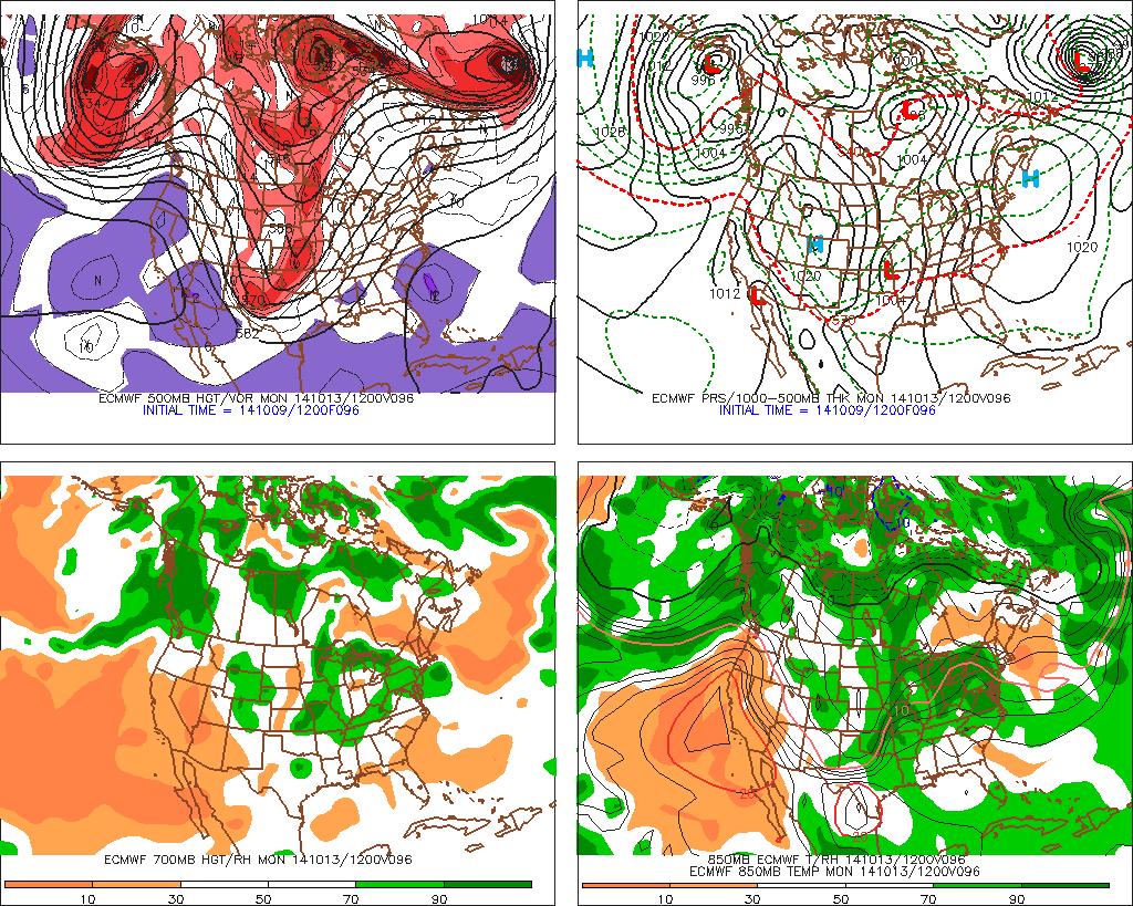
We note the GFS remains consistent on strong to severe storm potential Monday night into Tuesday morning while the European is more delayed (suggesting more of a threat during the day time Tuesday).  For now, we’re leaning more towards the GFS and we’ll have more on the early week severe threat Sunday.  Locally heavy rain is also a good bet during this time, including widespread 1″-1.5″, with locally heavier totals.

Taking The More Optimistic Approach…Some forecast data wants to keep considerable cloudiness and pesky light showers around into the mid week period, but for now we’re still going with the more optimistic outlook and including drier weather along with cooler temperatures for the balance of the upcoming work week.

Upcoming 7-Day Precipitation Forecast:

  • 7-Day Rainfall Forecast: 1-2″
  • 7-Day Snowfall Forecast: 0.00″
hires_ref_ky_61

We continue to highlight Monday night/ Tuesday morning for the potential of severe weather, including damaging straight line winds. Here’s what the high resolution NAM simulated radar suggests at 8p Monday local time.


Permanent link to this article: https://indywx.com/2014/10/11/cool-autumn-weekend-severe-storm-potential-monday-night/

Carefully Watching Monday Night/ Tuesday For Storm Potential…

While rain and chilly air are the headlines as we wrap up the work week and open another important college football weekend (my anticipation is building rapidly for my beloved Tigers taking on a dangerous MS. State squad Saturday afternoon- WAR EAGLE, btw), our attention is continuing to focus in on the potential of strong to severe thunderstorms Monday night and Tuesday morning across the region.

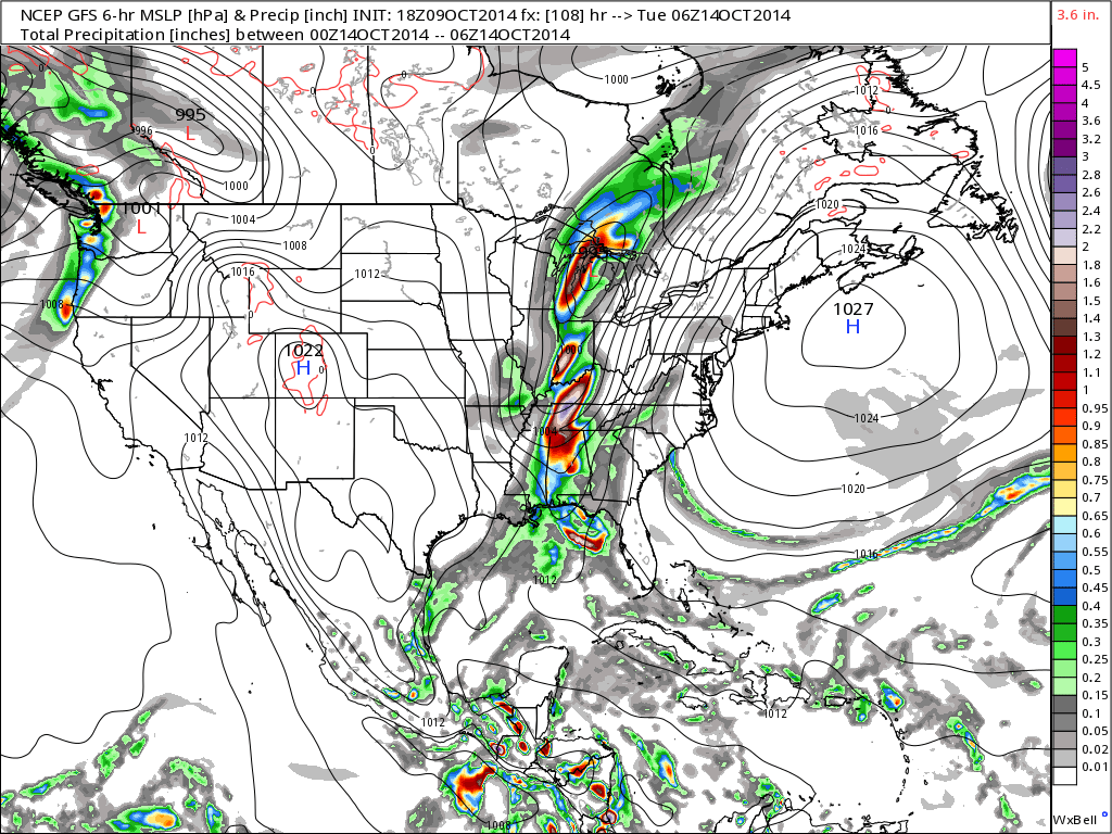
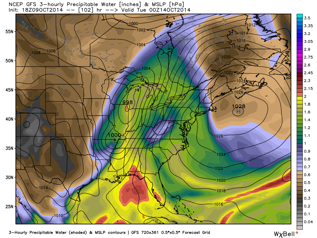
Forecast models continue to suggest strengthening low pressure will track northeast from MO into IL and MI Monday night into Tuesday morning.

gfs_slp_precip_conus_19

f96

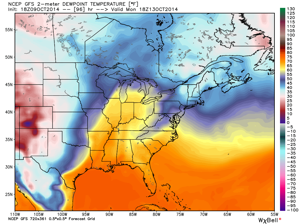
The region will briefly get into a warm and humid environment Monday and Monday night (plenty capable of fueling strong to severe thunderstorm development).  Temperatures in the 70s will combine with dew points in the low to mid 60s.

gfs_dew2m_east_33

A ribbon of precipitable water values will approach 2″ across the state Monday night.  This supports heavy and locally flash flood producing rainfall.  Forecast models continue to key on additional Monday-Tuesday rainfall in the 1-2″+ range.

gfs_pwat_mslp_east_35

We’ll continue to closely monitor the data as we move forward, but at this early juncture, make a mental note to be weather-aware Monday night into Tuesday morning as strong to severe thunderstorm potential develops.

Permanent link to this article: https://indywx.com/2014/10/09/carefully-watching-monday-night-tuesday-for-storm-potential/

Rainy Friday Or No?

Thursday will feature showers and unseasonably cool air. All in all, it won’t be a chamber of commerce day around these parts. Pack the rain gear and jacket! What’s up…

You must be logged in to view this content. Click Here to become a member of IndyWX.com for full access.  Already a member of IndyWx.com All-Access?  Log-in here.

Permanent link to this article: https://indywx.com/2014/10/08/rainy-friday-or-no/

Tuesday Morning Rambles…

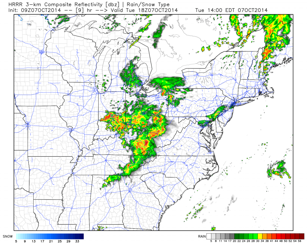
1.) We posted our weekly outlook last night and this can be found below.  An active weather pattern continues.  2.) A cold front will move through the region later this evening. As a result, showers and embedded thunder will be around into the afternoon hours before drier, cooler air builds in tonight behind the front.  Forecast radar shows rain and embedded storm chances continuing into the afternoon:

hrrr_ref_ma_10

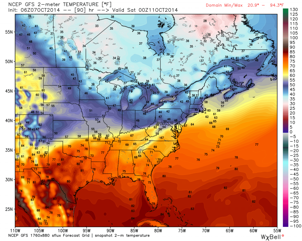
3.) Wednesday looks like the pick of the week with plentiful sunshine and pleasantly cool temperatures.  4.) Rain and storm chances return as early as Thursday into Friday.  5.) Friday stands to be quite an ugly day with rain chances and a new push of unseasonably chilly air.  A big thermal fight will be in place Friday as portions of northern Indiana don’t make it out of the 40s while temperatures across far southern areas of the state go into the 70s.  More specific to our region, look for falling daytime temperatures starting in the upper 50s.

gfs_t2m_east_31

Permanent link to this article: https://indywx.com/2014/10/07/tuesday-morning-rambles/

Weekly Outlook: Active And Cool!

Another active period of weather is in store for the region. (After an extended stretch of pleasant conditions from late September into the opening of October, I guess we shouldn’t complain too much).

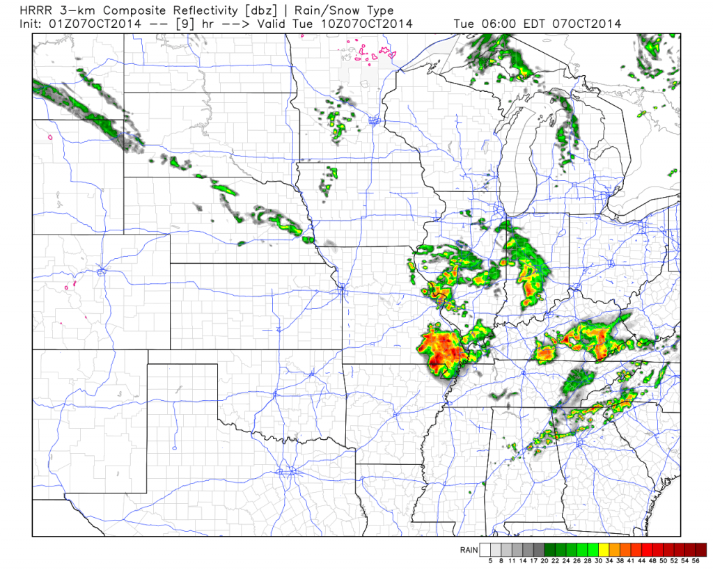
Dry days will be at a premium over the course of the upcoming 7-days.  The final in a series of disturbances in the fast northwest flow will blow through the region Tuesday.  This will offer up a threat of scattered showers and a possible rumble of thunder through the daytime hours. Latest forecast radar data suggests showers and embedded thunder will be ongoing Tuesday morning.

hrrr_ref_mc_10

After a dry day Wednesday (filled with lots of sunshine), we anticipate clouds and rain to quickly return as early as Thursday.  Forecast models handle the evolution of things differently at this juncture. For now, we’ll side with a blend of the GFS and Euro and serve up best rain chances late Thursday into Friday, followed by less concentration of rain Saturday, coupled with cool north winds.

gfs_slp_precip_conus_21

Saturday is a tough call at this point.  The cold front will be south of our area and chilly Canadian high pressure will be building in, but we may keep considerable cloudiness and pesky showers around (similar to last Saturday?). Stay tuned as we continue to fine tune.

Note the cooler than normal air settling in over the weekend.

gfs_t2m_anom_conus_21

7-day rainfall numbers vary greatly from model to model.  Upcoming weekly rainfall totals range from as little as 1″ to as much as 2″.  The Canadian model is the most aggressive, suggesting over 2″ on a widespread basis.

cmc_total_precip_mc_33

Just beyond this time next week we may be looking at an even more significant storm system, but we still have time to fine tune things as we move forward.

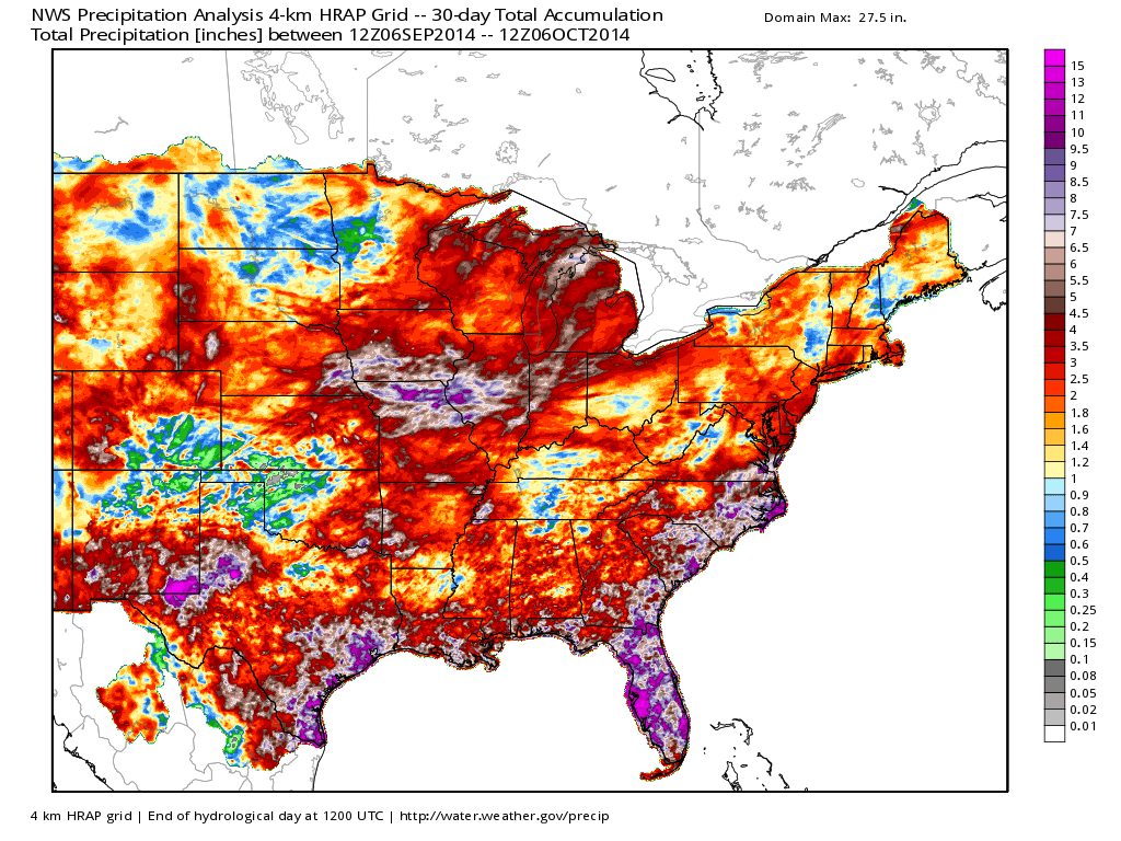
Despite the dry weather late September through October’s open, the past 30 days have featured beneficial to excessive Corn Belt rainfall…

nws_precip_east_30

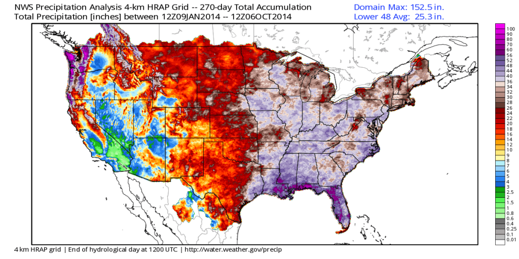
Year-to-date has featured a wet eastern region.  Also note the dry pattern across the southwest (some places under 1″ YTD)!  Officially, we’re just slightly wetter than normal at IND, year-to-date (+0.53″).

nws_precip_conus2_270

Thinking longer term towards the darker, colder, and snowier months ahead… The JAMSTEC remains “bullish” on a regime plenty capable of delivering the cold and snowy “goods” for the region…  BTW- we usually post our annual winter outlook the first Friday of October.  Things have been very hectic as of late and we’re going to have to delay this release by a few weeks….

ssta.glob.DJF2015.1sep2014temp2.glob.DJF2015.1sep2014tprep.glob.DJF2015.1sep2014

Permanent link to this article: https://indywx.com/2014/10/06/weekly-outlook-active-and-cool/

IndyWx.com