Category: Forecast Discussion

A Word On Meteoroligcal Winter

We wanted to take a moment and discuss the 2014-2015 meteorological winter.  Going into the winter, we knew this would be one of many challenges. The nearly ideal SST profile…

You must be logged in to view this content. Click Here to become a member of IndyWX.com for full access.  Already a member of IndyWx.com All-Access?  Log-in here.

Permanent link to this article: https://indywx.com/2015/03/03/a-word-on-meteoroligcal-winter/

A Lot To Discuss…

Good evening, friends!  As promised, there’s a lot on the weather menu over the course of the upcoming several days.  Let’s get right into the details.

The National Weather Service has issued a Winter Weather Advisory from 3a-12p for all of the region to account for the sleet and freezing rain situation we’ll deal with late tonight into the first half of Tuesday.  We still expect significant travel issues and overall impacts to the Tuesday morning commute.

Forecast radar shows freezing rain spreading into the region between 3 and 4am.
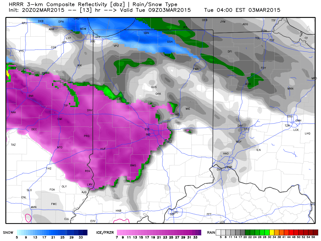
1Light freezing rain and freezing drizzle will continue for the better part of the morning hours as temperatures likely won’t climb above freezing until early Tuesday afternoon, especially from Indianapolis and points northeast.

Forecast temperatures at 12p Tuesday.
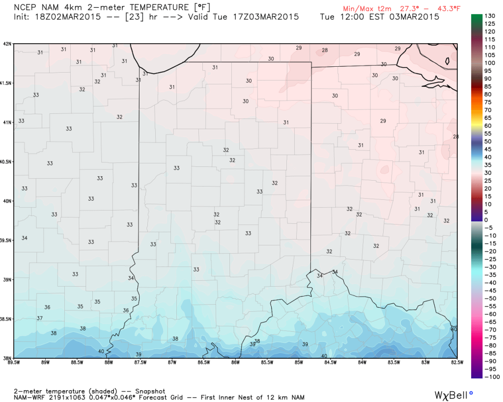
hires_t2m_indy_24We still don’t anticipate many big time flooding concerns as a.) temperatures won’t warm all that much (we MAY reach 40 Tuesday evening, but that’s a big question mark) and b.) most of the heavy rain will remain south of central Indiana.

Here’s expected liquid-equivalent totals through Wednesday morning.

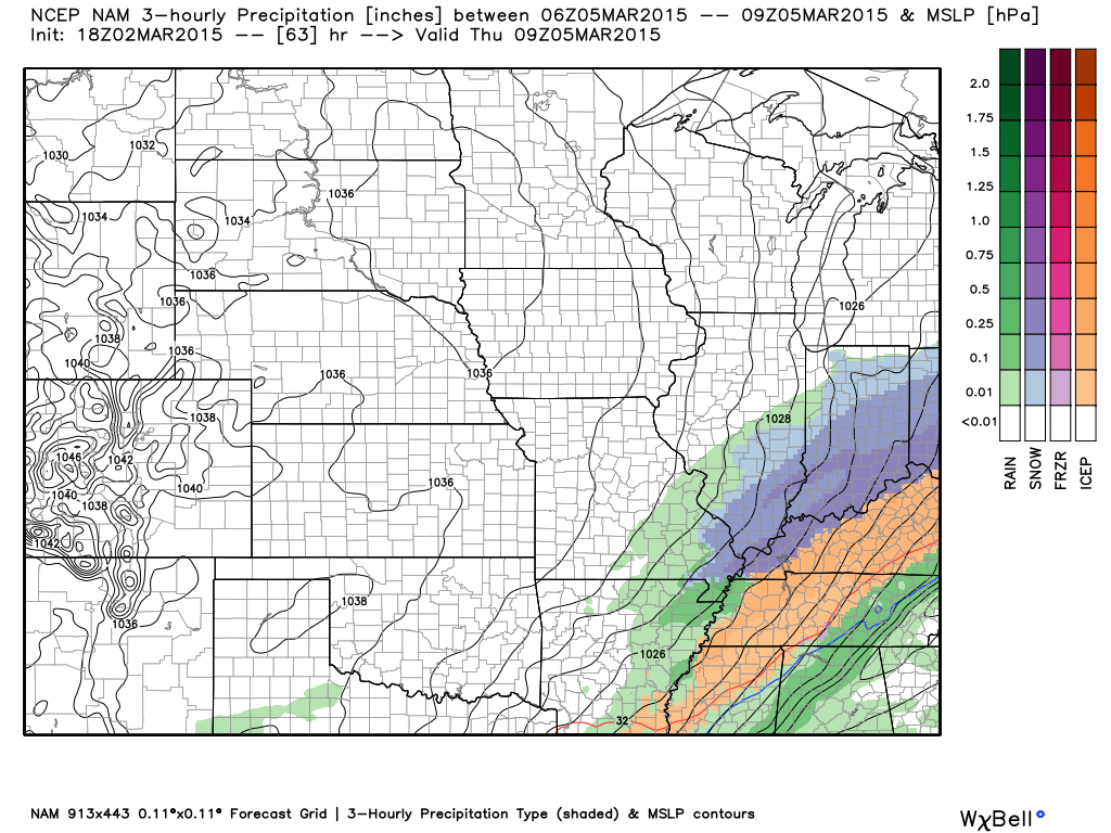
2The next concern is the threat of accumulating snow for central and southern portions of the state Wednesday afternoon through Thursday morning. Arctic high pressure will limit the northern extent of significant precipitation, but, as mentioned previously, energy rounding the base of the trough will ignite another wave of low pressure to move along the pressing arctic front.  As of now, we target areas along and south of the I-70 corridor most under the gun for a potentially impactful snow storm Wednesday afternoon into early Thursday morning.
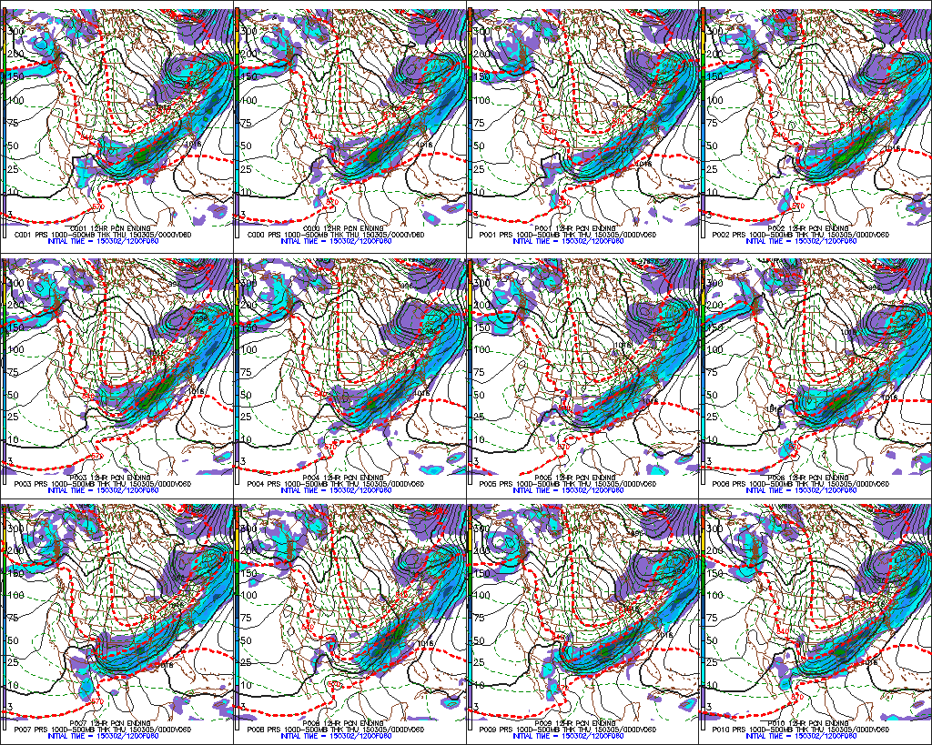
3The individual GFS ensemble members have also been trending north and overall more excited about snow prospects, as well.
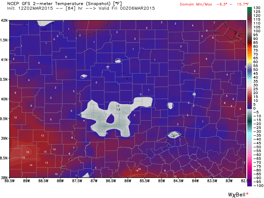
7The other item on the agenda is a shot of record cold in here for late week.  Sub-zero lows are a good bet by Friday morning.  Highs Thursday will push for a new record low maximum temperature.
4

Permanent link to this article: https://indywx.com/2015/03/02/a-lot-to-discuss/

Icy Tuesday Morning…

We continue to be very concerned about the likelihood of an icing event across central Indiana late tonight into early Tuesday afternoon. A significant snowpack in place won’t allow temperatures…

You must be logged in to view this content. Click Here to become a member of IndyWX.com for full access.  Already a member of IndyWx.com All-Access?  Log-in here.

Permanent link to this article: https://indywx.com/2015/03/02/icy-tuesday-morning/

More On This Week…

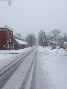
It was a record snowfall officially at IND where a storm total of 7.9″ was recorded (5.9″ accumulated since midnight). Many other 8″ type amounts are common throughout the heart of central Indiana- including right here at the IndyWx.com HQ.  Yours truly ventured out through the village of Zionsville this afternoon.  Simply beautiful!

HaleyBillSnow

ZvilleSnow3115


We have a busy weather week upcoming and wanted to touch base on a few items of note:

1.) Freezing rain and potential slick travel will be possible very late Monday night into Tuesday morning.  Moisture will attack from the southwest and run into an impressive snowpack currently in place across central Indiana.  Despite warmer air moving in aloft, surface temperatures will remain cold enough through late Tuesday morning to allow precipitation to fall in the form of sleet and freezing rain Tuesday morning.  It appears as if enough freezing rain could accumulate to result in slick travel throughout the region.  While temperatures will “warm” into the lower 40s Tuesday afternoon, this is a far cry from the lower 50s modeling tried to suggest a few days ago.  Furthermore, cold air will quickly rush back in here Tuesday night into Wednesday morning.

2.) Accumulating snow threat for the southern half of the state Wednesday into Thursday. Additional “energy” will round the base of a digging trough over the southern and central Plains states Wednesday. This will help ignite a surface low along the front and temporarily lead to the front stalling out just to our south and east.  It’ll be close as to just how far north the accumulating snow shield makes it across southern and central Indiana, but will require  a close eye in the coming day or two.  We note some of our more reliable modeling placing central and southern portions of the state “under fire” for additional accumulating snow.

3.) Serious and potentially record cold returns this week.  Yet ANOTHER blast of bitterly cold air will plunge into the area Wednesday night into Thursday.  With snow on the ground, it’s possible this direct discharge of arctic air is even colder than what some data might suggest at this time.  As it is already, we think some central Hoosier neighborhoods deal with sub-zero air in the Thursday/ Friday morning time frame.  Thursday’s high will only manage to climb into the teens across the region.  (Keep in mind the average low is 28 and average high is 45).  Just amazing stuff!

Permanent link to this article: https://indywx.com/2015/03/01/more-on-this-week/

Touching Base On Saturday Evening…

You must be logged in to view this content. Click Here to become a member of IndyWX.com for full access.  Already a member of IndyWx.com All-Access?  Log-in here.

Permanent link to this article: https://indywx.com/2015/02/28/touching-base-on-saturday-evening/

Saturday Morning Video Update…

You must be logged in to view this content. Click Here to become a member of IndyWX.com for full access.  Already a member of IndyWx.com All-Access?  Log-in here.

Permanent link to this article: https://indywx.com/2015/02/28/saturday-morning-video-update-3/

Snow Storm Brewing Saturday Night-Sunday…

We continue to closely monitor our developing situation Saturday night and Sunday. After reviewing all of the data this afternoon, we still have no real reason to believe the initial…

You must be logged in to view this content. Click Here to become a member of IndyWX.com for full access.  Already a member of IndyWx.com All-Access?  Log-in here.

Permanent link to this article: https://indywx.com/2015/02/27/snow-storm-brewing-saturday-night-sunday/

Friday Morning…

Good morning, friends! Not much has changed overnight with our thinking in regards to our winter storm late Saturday night through Sunday. We’ll have our first official snowfall forecast map…

You must be logged in to view this content. Click Here to become a member of IndyWX.com for full access.  Already a member of IndyWx.com All-Access?  Log-in here.

Permanent link to this article: https://indywx.com/2015/02/27/friday-morning/

Weekend Snow Storm Brewing…

As the weekend approaches, we’re getting set for another winter storm across the Hoosier state.

After two brutally cold days in Friday and Saturday, our eyes will shift to a potentially hefty snow storm late Saturday night into Monday morning.  This will be a bit of a different set up from what previous storms this winter have provided.  A relatively “flat” wave of low pressure will move out of the southern Plains Saturday and slowly through the southern Ohio Valley Sunday.  Widespread precipitation will overspread the region late Saturday night and continue through most of Sunday, and even into early Monday in some cases.  This will be a relatively long duration event and the impacts will likely be high from a travel perspective Sunday into Monday morning.

1


2


Concerning precipitation type, we still believe the combination of a bitterly cold pattern and a widespread snow pack will play a significant role in this event.  It’s always difficult to get more than a wintry form of precipitation when moisture “attacks” true arctic air.  As of now we see this storm being an all snow event for places around and north of the I-70 corridor.  South of there, it’s possible mixing gets involved- including potentially some freezing rain downstate.

Due to the fact that this should be a rather prolonged event, significant snowfall will be possible where precipitation stays (or remains predominantly) snow.

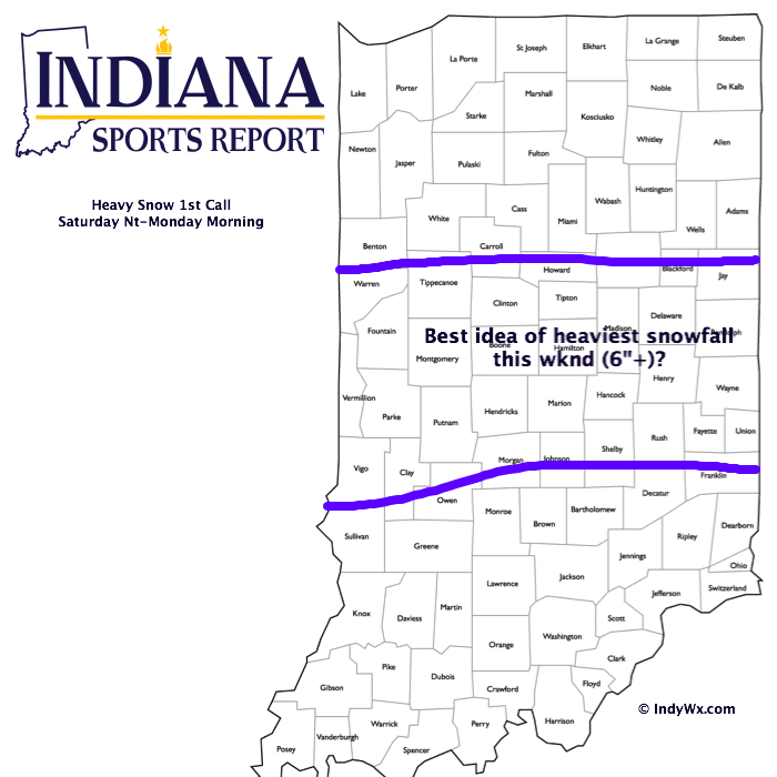
Here’s our best guess where the heaviest snowfall potential lies currently.  Remember, snow totals won’t necessarily follow the clean lines below.  This should be used as guidance at this point for where we’re focusing our attention for the potential of heaviest snowfall totals.  Being that this is still an event late Saturday night through Monday morning, obviously things are subject to change.  We’ll have our first specific accumulation map posted Friday evening.  Stay tuned.

29151stcall

Permanent link to this article: https://indywx.com/2015/02/26/weekend-snow-storm-brewing-2/

Thursday Morning…

Very busy day on tap so a more in depth post will have to wait until later this evening. Here’s what’s on our plate over the next 5-7 days: 1.)…

You must be logged in to view this content. Click Here to become a member of IndyWX.com for full access.  Already a member of IndyWx.com All-Access?  Log-in here.

Permanent link to this article: https://indywx.com/2015/02/26/thursday-morning/

IndyWx.com