Category: Forecast Discussion

Monday Weather Notebook…

*We’re going to begin posting a discussion going into more detail around the what and why of the seven day forecast in the mornings, followed by the actual updated 7-day…

You must be logged in to view this content. Click Here to become a member of IndyWX.com for full access.  Already a member of IndyWx.com All-Access?  Log-in here.

Permanent link to this article: https://indywx.com/2015/08/17/monday-weather-notebook/

Saturday Morning Rambles…

1.) With the first half of August in the books, it’s been slightly cooler than normal with slightly below normal precipitation (-0.94″).       2.) A broken line of showers…

You must be logged in to view this content. Click Here to become a member of IndyWX.com for full access.  Already a member of IndyWx.com All-Access?  Log-in here.

Permanent link to this article: https://indywx.com/2015/08/15/saturday-morning-rambles-6/

Thoughts Shifting To Fall And Winter…

We may only be in mid August, but the IndyWx.com office is busy putting together initial thoughts around fall and winter (it’ll be here before you know it)! The upcoming…

You must be logged in to view this content. Click Here to become a member of IndyWX.com for full access.  Already a member of IndyWx.com All-Access?  Log-in here.

Permanent link to this article: https://indywx.com/2015/08/13/thoughts-shifting-to-fall-and-winter/

Dry Push Of Air Arrives Tonight…

The morning has dawned with patchy dense fog in spots. Be careful traveling to work and school this morning.  Most of today will be dry, but an isolated shower/ sprinkles…

You must be logged in to view this content. Click Here to become a member of IndyWX.com for full access.  Already a member of IndyWx.com All-Access?  Log-in here.

Permanent link to this article: https://indywx.com/2015/08/11/dry-push-of-air-arrives-tonight/

Sunday Morning Weather Rambles…

1. August has gotten off to a cool start through the first eight days and we expect this to continue during the upcoming week, only growing cooler, relative to the…

You must be logged in to view this content. Click Here to become a member of IndyWX.com for full access.  Already a member of IndyWx.com All-Access?  Log-in here.

Permanent link to this article: https://indywx.com/2015/08/09/sunday-morning-weather-rambles-2/

Awesome Close To The Work Week; Weekend Thoughts…

Thursday’s rain is now long gone. Heaviest rains fell south as expected. (Numbers below are only through 24 hours ago).    Many reporting sites across central Indiana are returning numbers…

You must be logged in to view this content. Click Here to become a member of IndyWX.com for full access.  Already a member of IndyWx.com All-Access?  Log-in here.

Permanent link to this article: https://indywx.com/2015/08/07/awesome-close-to-the-work-week-weekend-thoughts/

Wednesday Morning Update…

Good morning and happy Wednesday! Forecast models continue to provide a bit of a headache concerning our developing weather situation, but here’s our best take moving forward: The morning is…

You must be logged in to view this content. Click Here to become a member of IndyWX.com for full access.  Already a member of IndyWx.com All-Access?  Log-in here.

Permanent link to this article: https://indywx.com/2015/08/05/wednesday-morning-update/

Model Consensus Is South With Thursday Rain, Except The High-Resolution NAM…

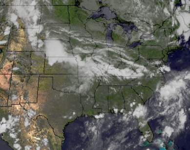
Mid and high level cloudiness continue to drift into the state this evening and we note some rain and storms downstate.  Across central Indiana, all-in-all it’s a very pleasant evening, including very comfy temperatures and humidity levels for early August.
Screen Shot 2015-08-04 at 6.35.54 PM


Model consensus today has been to shift the axis of heavy rain across southern Indiana Wednesday night and Thursday, including some locally heavy totals with flooding possible.
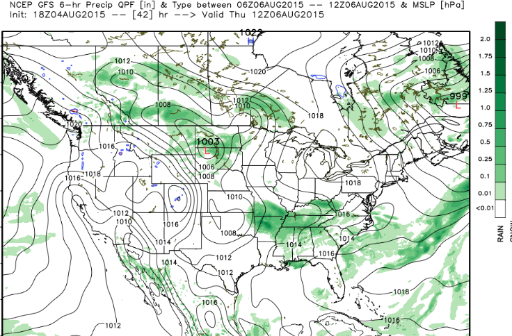
Screen Shot 2015-08-04 at 6.36.26 PMWe show the GFS above and we note the European, NAM, and Canadian all agree with the overall idea of heaviest rain across southern Indiana and points south.

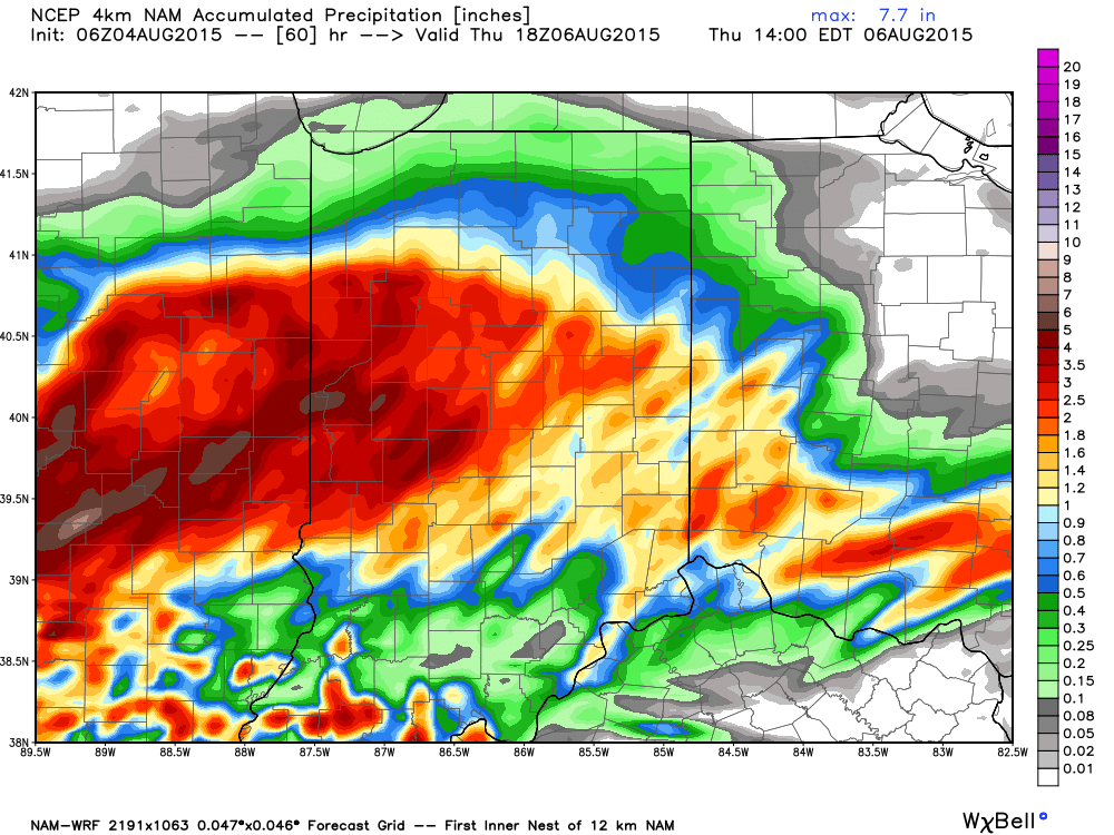
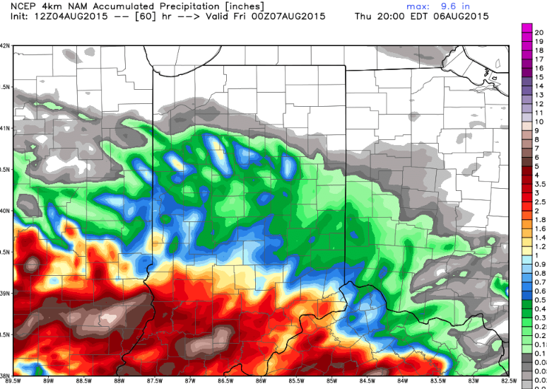
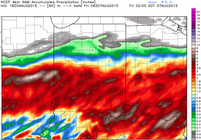
Just as we were beginning to get all modeling onboard with the southern shift, the latest high-resolution NAM has shifted back north rather considerably.  Note the difference in rainfall totals expected from the high resolution NAM just from the 12z run to the latest 18z run.
Screen Shot 2015-08-04 at 6.44.49 PM


Screen Shot 2015-08-04 at 6.36.59 PM

No doubt the high resolution NAM is an anomaly, but we also can’t totally discard this solution just yet either based off the longer term projections and relative consistency just a couple days ago.  The higher resolution models can handle these type systems better at times so we’ll keep a close eye on things.

Confidence should increase rather dramatically with tonight’s model runs and we’ll be up to watch those trickle in.

Permanent link to this article: https://indywx.com/2015/08/04/model-consensus-is-south-with-thursday-rain-except-the-high-resolution-nam/

Still Some Question On Northward Extent Of Heavy Rain…

The morning is off to a beautiful start as drier air oozed into central IN overnight.  Many reporting sites are returning numbers in the middle 50s this morning!  Anyone else craving fall?

While a beautiful day is in store locally, we note clouds associated with a storm complex off to our northwest this morning.  Some of these clouds could blow into central IN at some point this afternoon or evening.

As we fast forward to mid week the cold front that’s currently to our south will lift back north as a warm front.  This will be in response to surface low pressure tracking in west to east fashion through the central Plains and into the Ohio Valley.  That said, there’s precise details still not etched in stone that can, and will, have a large impact on our weather (locally) Wednesday night though Thursday.  Note some of the differences with just a few of our forecast models in regards to heavy rainfall placement:

High-resolution NAM

1GFS (interestingly the 6z GFS shunted the rain farther south):

5Canadian:

3* The European most closely resembles the 0z GFS run.

We still have time to sort through the details in regards to the precise placement of heaviest rain, but for now we’re keeping widespread rain and embedded thunder in the forecast Wednesday night through Thursday.

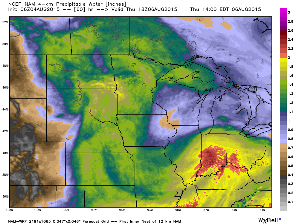
Note precipitable water values exceeding 2″ in spots Thursday.  This will certainly support locally heavy rain and a flash flood threat for portions of the state during the aforementioned time period.  Much more later this evening!

2

Permanent link to this article: https://indywx.com/2015/08/04/still-some-question-on-northward-extent-of-heavy-rain/

Weather Rambles To Wrap Up The Work Week…

   1.) The high resolution NAM has been consistent on trying to deliver a skinny line of showers and thunderstorms into central Indiana Friday evening. We’ll keep an eye on…

You must be logged in to view this content. Click Here to become a member of IndyWX.com for full access.  Already a member of IndyWx.com All-Access?  Log-in here.

Permanent link to this article: https://indywx.com/2015/07/30/weather-rambles-to-wrap-up-the-work-week/

IndyWx.com