Category: Forecast Discussion

Client Brief: Thursday Evening Update…

Updated 03.02.23 @ 11:03p

Type: Flooding and Severe Weather; North-Central IN Wet Snow

What: Heavy rain and severe weather; north-central Indiana heavy wet snow

When: Friday, 3/3/23

Wind: Variable 20-30 MPH with gusts to 50 MPH

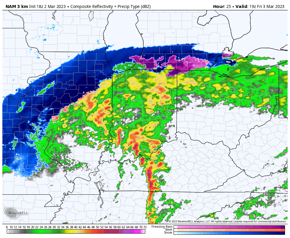
Summary: A deepening area of low pressure will track into the central Ohio Valley as we close the work week. This will lead to an expanding area of heavy precipitation through the overnight and into Friday morning. Precipitation will fall in the form of heavy rain across central portions of the region, including the Indianapolis area, along with a flood threat. Further north, heavy wet snow will develop across northern IN, into the greater CHI area and into central MI. Note: Early 00z guidance is shifting this area of low pressure further southeast which puts more of north-central parts of the state in play for wet snow accumulation Friday afternoon. We’ll continue to monitor overnight trends but the possibility is there that the rain-snow line will have to shift south compared to what most of the data has been showing the past couple of days. Widespread rainfall amounts of 2”+ can be expected into central IN along with non-thunderstorm gusts of 50+ MPH.

We bracket the 1p to 4p window for the threat of severe storms. This risk lies from Indianapolis proper and points south. We anticipate a line of storms to “bow” out, leading to an elevated damaging wind threat across southern IN during this time period but we also note the potential of a couple of quick spin-up tornadoes within this line of storms, as well. It’ll be important to have a means of getting any and all warnings Friday. Keep tuned to local media or have a way to receive the latest National Weather Service updates. All of the “action,” including the heavy rain threat is expected to wind down Friday evening, including much calmer and quieter conditions returning Friday night.

We’ll be back with a fresh video discussion no later than 7:30a Friday.

Permanent link to this article: https://indywx.com/client-brief-thursday-evening-update/

VIDEO: Dynamic Storm System Delivers Heavy Rain, Strong Winds, And Potential Of Severe Storms To The Area Friday…

Updated 03.02.23 @ 7:40a

You must be logged in to view this content. Click Here to become a member of IndyWX.com for full access.  Already a member of IndyWx.com All-Access?  Log-in here.

Permanent link to this article: https://indywx.com/video-dynamic-storm-system-delivers-heavy-rain-strong-winds-and-potential-of-severe-storms-to-the-area-friday/

VIDEO: Wind Driven Heavy Rain To Close The Work Week; Heading Backwards In The Longer Term…

Updated 03.01.23 @ 7:45a

You must be logged in to view this content. Click Here to become a member of IndyWX.com for full access.  Already a member of IndyWx.com All-Access?  Log-in here.

Permanent link to this article: https://indywx.com/video-wind-driven-heavy-rain-to-close-the-work-week-heading-backwards-in-the-longer-term/

VIDEO: Heavy, Wind-Whipped Rain Arrives To Close The Work Week…

Updated 02.28.23 @ 7:18a

You must be logged in to view this content. Click Here to become a member of IndyWX.com for full access.  Already a member of IndyWx.com All-Access?  Log-in here.

Permanent link to this article: https://indywx.com/video-heavy-wind-whipped-rain-arrives-to-close-the-work-week/

Spring “Tease” Just That; Long, Long Road Ahead…

Updated 02.27.23 @ 6:15p

Temperatures are running around 7° above normal at IND February to-date, and the first few days of March will also get off to a well above normal start. Winter, as a whole, aside from the bitter pre-Christmas blast, has been absolutely forgettable to most winter weather enthusiasts. I suppose it only makes sense that just as most are ready for “stick and hold” spring weather to show itself, we are seeing the best alignment and most bullish signal for persistent anomalous cold from a variety of pattern drivers all winter long. 😉

Long time IndyWx viewers know that this is the time of year we lean heaviest of NAO impacts, particularly if in a negative state. Latest long range data places the NAO in a negative state for the better part of the upcoming (6) weeks:

This strongly argues for more of a persistent eastern trough, including below normal temperatures and an active storm track, thanks to the busy Pacific pattern.

Secondly, and we really should have started with this one, the Madden-Julian Oscillation is finally set to rotate into the traditionally cold phases (8 and then 1) as we flip the page to the 2nd week of March and beyond. This should eventually translate into a widespread cold pattern, including the East, with an active coast-to-coast storm track continuing. Also note the high latitude blocking emerging as we transition into Phase 1.

Throw in a negative WPO, and this further backs up the widespread cold, active pattern. Similar to the NAO chart to open this piece, the majority of the (6) week period is spent in a negative state. Pattern alignment…

Add in all of this and there’s no wonder the most updated (as of this afternoon) European Weeklies are banging the drum, quite loudly I might add, for a prolonged period of colder than normal weather from mid-March through mid-April. Don’t put away that cold weather gear- or snow shovels just yet…

Permanent link to this article: https://indywx.com/spring-tease-just-that-long-long-road-ahead/