Category: Forecast Discussion

Cut Off Upper Low, Weatherman’s Woe…

Updated 12.27.23 @ 6:55a

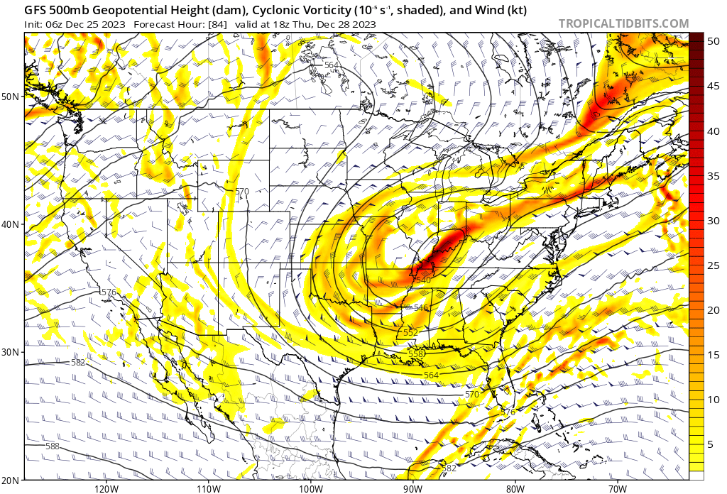
A big ole slow moving cut off upper level low pressure system will pinwheel out of the upper Midwest this morning into the TN Valley and Southeast by the weekend.

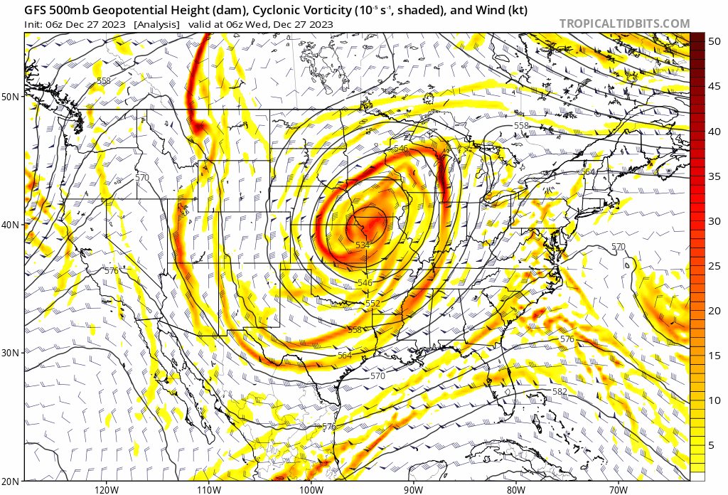
These features are always known for “surprises” and it’s up to forecasters, including yours truly, to eliminate those surprises over the next couple days. The challenging part with this particular setup is that colder air will be arriving into the region as the more organized bands of precipitation are pivoting south. Precipitation intensity will also be a big player in this event. The heavier, or more intense, precipitation rates will be able to cool the column of air perhaps a bit quicker than most short term model guidance may currently see.

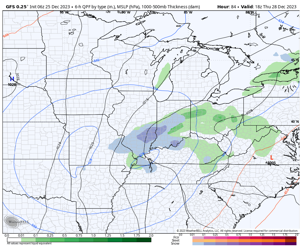
So what does this all mean to me? Today is quiet. After patchy fog burns off, we’re looking at more in the way of sunshine building in. The initial band of precipitation will likely setup tonight across southwestern Indiana. While this will start out as a cold rain, precipitation should switch over to snow prior to sunrise and some localized wet accumulation of snow is likely across Southwest Indiana by daybreak Thursday.

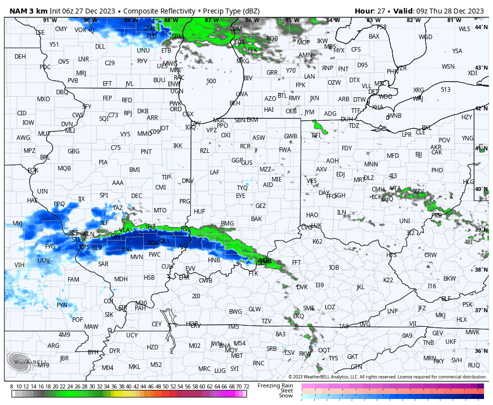
Meanwhile, back up this way, after a dry start to the day, precipitation is expected to become more widespread by early to mid afternoon. As nightfall sets in, rain will likely turn to wet snow showers. Admittedly tricky trying to determine where the steadiest band of precipitation will prevail, the best idea at this point will be across west-central Indiana, including places like Frankfort, Lafayette, Crawfordsville, and Terre Haute. Here, light wet snow accumulation of 1” to 2” seems like a good bet by Friday morning.

Precipitation will diminish from north to south across western Indiana Friday morning. Dry conditions will return until a reinforcing jab of cold air arrives New Year’s Day with scattered snow showers.

Permanent link to this article: https://indywx.com/cut-off-upper-low-weathermans-woe/

VIDEO: Turning Cooler; Couple Chances Of Light Precipitation…

Updated 12.26.23 @ 6:16a We begin to turn cooler through the day and this sets the tone for a more seasonable close to the year. We’ll continue to watch the…

You must be logged in to view this content. Click Here to become a member of IndyWX.com for full access.  Already a member of IndyWx.com All-Access?  Log-in here.

Permanent link to this article: https://indywx.com/video-turning-cooler-couple-chances-of-light-precipitation/

Wishing You A Very Merry Christmas And A Blessed Holiday Season…

Updated 12.25.23 @ 6:58a

From our family to yours, we wish you warmest Christmas blessings and a joyous holiday season!

After a dry start to the day, rain will lift north and overspread central Indiana late morning into the early afternoon. A few moderate showers are likely at times. Rainfall coverage and intensity will diminish significantly as we move through mid and late evening. Though there will be a few exceptions, generally 0.50” to 0.75” will fall south of the I-70 corridor with amounts of 0.25” to 0.50” north of I-70.

1p forecast radar
4p forecast radar
11p forecast radar
Rainfall totals by noon Tuesday.

Strong southeasterly winds and unseasonably mild temperatures can also be expected today. Gusts will approach 40 MPH this afternoon across all of the region.

Our weather will dry out Tuesday and Wednesday but by this time all eyes will be poised to our west as we wait in the cold core upper level low to pivot across the region. While there won’t be a lot of cold air readily available for this system to tap into, we’ll have to see if it can manufacture its own cold air to create some potential localized winter weather “issues” for portions of the southern Ohio Valley and especially the Appalachians prior to the New Year’s weekend. For now, we’ll forecast a mix of rain and snow here Thursday- just know that we’ll likely have to firm that up once the details become clearer regarding the exact track of the upper low. As the ole saying goes, “cold core upper low, weatherman’s woe.” Solutions range from a cold rain to a localized accumulating wet snow event…

Permanent link to this article: https://indywx.com/wishing-you-a-very-merry-christmas-and-a-blessed-holiday-season/

VIDEO: Fog Lifts And Gives Way To Unseasonably Mild Conditions; Christmas Rain And Colder Transition Later In The Week…

Updated 12.24.23 @ 6:50a Areas of fog and drizzle will dissipate as we progress through the day and we even expect some breaks in the clouds at times. An unseasonably…

You must be logged in to view this content. Click Here to become a member of IndyWX.com for full access.  Already a member of IndyWx.com All-Access?  Log-in here.

Permanent link to this article: https://indywx.com/video-fog-lifts-and-gives-way-to-unseasonably-mild-conditions-christmas-rain-and-colder-transition-later-in-the-week/

A Tale Of 2 Potential Extremes For Late January And An Early Lean…

Updated 12.23.23 @ 3:04p

The stage has been set for some time concerning late December and the first week to 10 days of January. There are no changes on our ideas concerning that timeframe. In short, a colder (certainly from where we’ve been as of late, and slightly below the average), and stormy evolution sums up that period.

The timeframe now in question has to do with mid and late January, after what sure looks to be a 5-7 day period of moderation. Unlike what we’ve outlined for late December and early January, the second half of January is likely to feature more in the way of a case of “extreme and nothing in between” type pattern. As outlined in Thursday’s long range post, up to this point, modeling has a couple of different takes on the aforementioned period. The American guidance suggests a repeat of well above normal temperatures and a general lack of winter weather looms with an MJO look poised for the classic warm phases.

You likely don’t need us to remind you of January and February last year. Indianapolis ran a whopping 8.1° above normal through the first couple months of the year.

The reason? An amplified MJO rolling slowly through the Phases 3, 4, and 5 before getting into the colder phases late February and into March.

Back to present day, the American guidance, though slowly backing off from the aggressive idea from a couple days ago, suggests this is once again on the table. Should that come to fruition, mid January would feature well above normal temperatures yet again.

As the great Lee Corso famously coined, “not so fast, my friend.” The European guidance collapses the MJO into the null, or neural phase, before getting into the warm phases. While a period of moderation still will likely follow the chilly open to January, should the Euro idea be correct (and we suspect it is- more on that below), an eventual recycling through the cold phases would likely ensue late January into early February.

By this point, guidance is also beginning to align on other important pattern drivers. Remember, by mid January, we really start to lean in on what the NAO and AO are doing. That’s certainly not to say we don’t pay attention to the PNA and EPO- just that the AO/ NAO can have greater influence on the regime into early spring. Of course, the MJO remains king.

What’s interesting is that each respective “driver” positions itself in a manner that argues cold should rule during the late January and early February period.

Should that MJO circle back into the traditional cold phases, look out. The window will open for a period of true arctic air getting involved with the pattern given the other pattern drivers above. – Target period would be late January (after Jan. 15th) and into early February.

Given what’s out there for the taking, it’s certainly not a pattern for the faint of heart. Buckle up!

Permanent link to this article: https://indywx.com/a-tale-of-2-potential-extremes-for-late-january-and-an-early-lean/