Saturday will once again dawn on a gloomy note, with cloudy skies, areas of dense fog, and drizzle, but we’re not looking at measurable rainfall across central Indiana until we…
You must be logged in to view this content. Click Here to become a member of IndyWX.com for full access. Already a member of IndyWx.com All-Access? Log-in here.
Updated 01.26.24 @ 7:38a A quiet but gloomy and unseasonably mild close to the work week can be expected before a weak system skirts the region Saturday evening into predawn…
You must be logged in to view this content. Click Here to become a member of IndyWX.com for full access. Already a member of IndyWx.com All-Access? Log-in here.
Permanent link to this article: https://indywx.com/video-wet-snow-accumulation-for-parts-of-the-region-sunday-morning-pattern-evolution-into-early-march/
Updated 01.25.24 @ 7:36a Dense fog is present yet again this morning, but at least we’re not dealing with heavy rain. That changes later this evening as a slug of…
You must be logged in to view this content. Click Here to become a member of IndyWX.com for full access. Already a member of IndyWx.com All-Access? Log-in here.
Permanent link to this article: https://indywx.com/video-source-region-change-for-our-storm-systems-between-now-and-next-week-establishing-a-bar-on-just-how-cold-we-get-next-month/
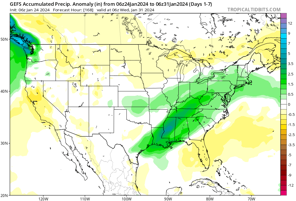
Week 1 remains significantly wetter than normal across not only our neck of the woods but a good chunk of the East.
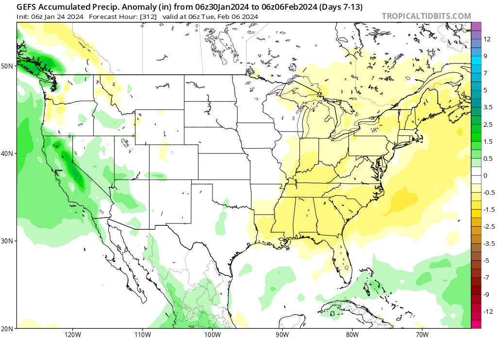
This will give way to a quieter Week 2 timeframe.
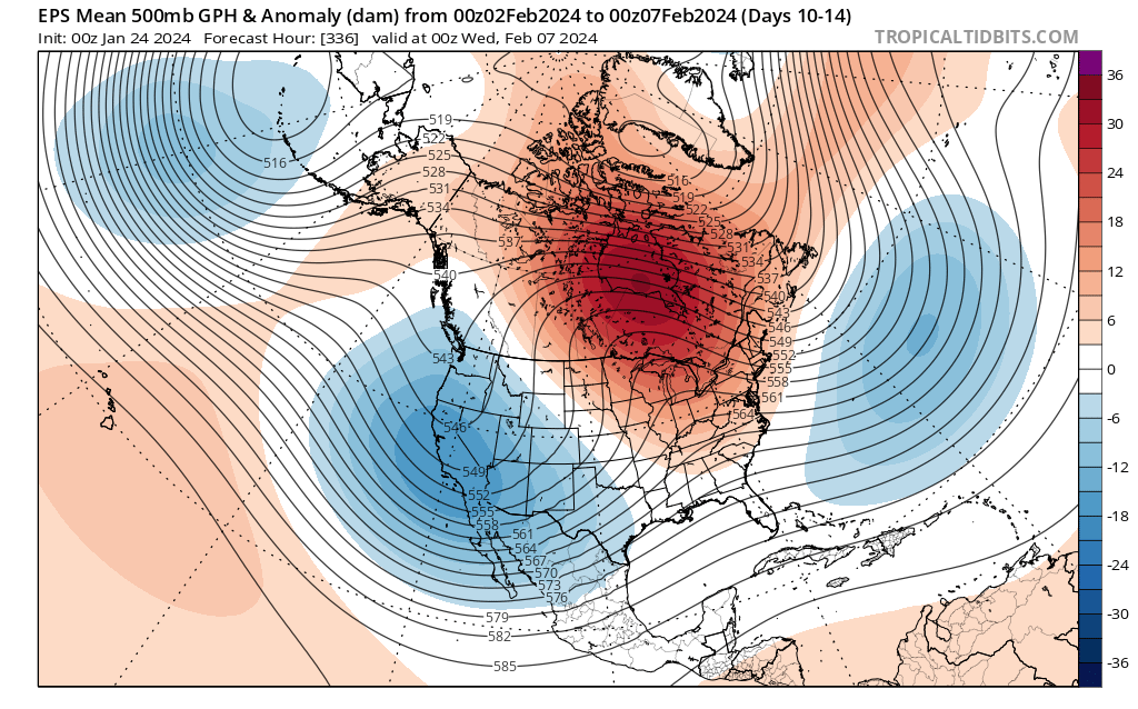
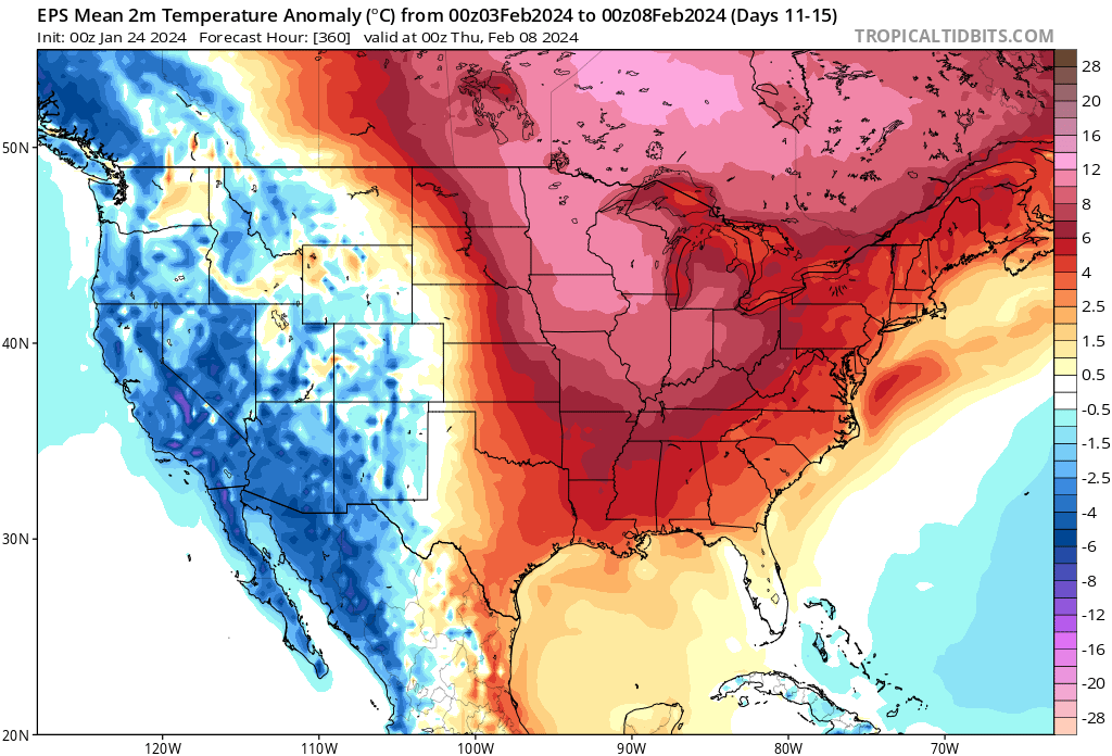
There’s some threat that the southern tier and immediate eastern seaboard never is fully able to relish in the magnitude of the warm anomalies the majority of the rest of us will see as we roll through early February. Just to reiterate, as much as we believe cold, wintry weather returns in February, it’s not after a significant period of milder times (compared to average) to open the month- likely the first 10-14 days.
Just how mild are we talking? Several days with highs into the 40s and even 50s and overnight lows in the low to mid 30s. This compares to early Feb “norms” in the low 20s and highs into the upper 30s. It’s a byproduct of the MJO and alignment with the teleconnections (PNA aside) in the warm phases. As shown Monday in our LR video, we believe this all flips around in a big way later into the month, continuing into March.
In the short term, additional waves of rain (and dense fog) will keep things gloomy around these parts. Most widespread rain will come at us now through late morning before returning Thursday evening-overnight. Most rain gauges can expect to pick up an additional 0.75” to as much as 1.25”+ during this time period.
Modeling continues to differ in a major fashion with the weekend storm. The GFS is further north with heavy precipitation and a transition to leftover snow showers, locally while the European takes the suppressed route. Today will likely bring alignment between the two solutions. . .
Overall, we don’t have any changes to our ongoing ideas from last night’s video. If you didn’t have an opportunity to catch that, we encourage you to do so as it highlights our medium and long range thoughts in more detail.
The focus will change from one of ice to periods of rain (and dense fog) through the remainder of the week. We note multiple waves of more widespread rain that will ride into central Indiana over the next few days. While it won’t rain the entire time, an extended period of gloomy conditions will unfortunately be with us as we navigate the next few days and kick off the weekend.
Periods of rain can be expected through the remainder of the week.
Speaking of the weekend, we continue to closely monitor an area of low pressure that appears to take a classic track for a heavy snow dump around these parts. The problem? Cold air is fleeting and it’ll take the perfect combination of track, timing, and precipitation rates to generate anything meaningful from a wintry standpoint, locally. As of now, we favor this “sweet spot” to lay just north of our immediate area, but we’ll continue to closely monitor.
That brings us to our final point this morning and that’s wanting to ensure we drive home the idea here of an overall milder to significantly milder than normal pattern over the upcoming 10-14 days as a whole. While we’re incredibly bullish on winter’s return, we’re equally as impressed by this overall milder signal in the short to medium term.