Category: Fog
 Highlights:
- AM fog gives way to lots of sunshine
- Early fall preview
- Warmer days return
- Spotty weekend storms possible
We still have warm to hot days left before we get into true fall air, but the next couple days will have many craving the autumnal season ahead. It’s not every year we can say mid August will feature lows in the mid to upper 50s and highs in the 70s, but that’s the case for Wednesday. Despite some patchy dense fog in spots, look for wall-to-wall sunshine today, continuing right through the end of the work week. Have an extra vacation day or two to use at work? Might we suggest burning them over the next 48-72 hours? 😉
Warmth and humidity will return heading into the weekend and on into early next week. Additionally, we’ll have to keep a close eye on weak upper level disturbances moving into the region. They may provide just enough “umph” to spark isolated storms over the weekend. Better coverage of thunderstorms can be expected early next week.
Upcoming 7-Day Rainfall Forecast: 0.25″ – 0.50″
Permanent link to this article: https://indywx.com/early-fall-preview/

Much Needed Vitamin D…After a cloudy, rainy, and gloomy Tuesday, we’ll welcome the sunshine with open arms today and Thursday. Before we talk about the brighter times ahead, beware of areas of dense fog remaining in place through about the lunch hour. The combination of a wet ground and overnight clearing led to rather widespread dense fog across the region. Eventually, the high March sun angle should lead to increasing sunshine as we progress through the day Wednesday. Thursday will feature lots of sunshine. Both days will be unseasonably mild, though today’s high will be largely dependent on just how soon we clear things out.
Another slug of Gulf of Mexico moisture will move north and impact the region to wrap up the work week. Widespread significant rainfall is a good bet Friday into the first half of Saturday.
The weekend won’t be a total washout as sunshine returns Sunday. Temperatures will remain mild!
Another push of resurgent warmth can be expected Monday as highs zoom into the lower 60s with a southwest flow in place before a dry cold front passes through here Monday night/ Tuesday.
Upcoming 7-Day Precipitation Forecast:
- 7-Day Rainfall Forecast: 1.00″ – 1.50″
- 7-Day Snowfall Forecast: 0.00″
Permanent link to this article: https://indywx.com/brighter-days-ahead-and-spring-like-air/
-
Filed under 7-Day Outlook, Arctic Cold, Christmas/ Thanksgiving, Fog, Forecast, Freezing Fog, Freezing Rain, Sleet, snow, Unseasonably Cool Weather
-
December 29, 2014
|
Mon.
|
Tue.
|
Wed.
|
Thr.
|
Fri.
|
Sat.
|
Sun.
|
 |
|
|
|
 |
|
|
|
20/ 35
|
22/ 29
|
14/ 22
|
18/ 31
|
22/ 32
|
25/ 34
|
31/ 37
|
Highlights:
- Freezing For For Some This Morning
- Sunny And Very Cold Weather To Close 2014
- Weekend Wintry Event
Patchy Freezing Fog; Sunny And Cold…Patchy freezing fog has created slick spots on some roadways this morning, particularly just north of the city. This should burn off relatively quickly this morning and give way to partly cloudy skies this afternoon. A frosty start will “warm” into the middle 30s later this afternoon.
Stretch Of Dry, But Very Cold Weather…A sprawling arctic high will impact our weather to wrap up 2014 and welcome in 2015. The result will be an extended stretch of sunny days, but bitterly cold air. For all of those hosting New Year’s Eve parties this year, we might suggest having extra wood for that cozy fire!
Late Week Storm System…We’ll introduce a wintry mix of snow, sleet, and freezing rain into your forecast as early as Friday afternoon. While there are still some issues concerning track and timing, we’ll continue the chance of a wintry mix through the weekend. Stay tuned.
Upcoming 7-Day Precipitation Forecast:
- 7-Day Rainfall Forecast: 0.10″ – 0.20″
- 7-Day Snowfall Forecast: 1″ – 2″
Permanent link to this article: https://indywx.com/morning-freezing-fog-in-spots-sunny-and-cold/
Colts v. Texans Forecast Prepared For:
The Indiana Sports Report
12.14.14
Happy game day Colts fans! – New day; same story…central Indiana will remain under the influence of an “inversion” and this will keep low clouds and areas of fog prevalent for most of the day. Milder air in the 50s at 4,000-5,000 feet up is overrunning shallow cooler air that’s trapped at the surface and the result in more of the same- gloomy, cloudy, foggy weather. While temperatures won’t be as mild as they could be without the inversion, tailgaters still can’t complain about 45-50 degree air this time of year :-). Visit IndyWx.com for “Indy’s Behind The Scenes Weather” all season long! Go Colts!
|
Tailgate Weather
|
Kickoff Weather
|
Heading Home
|
| Cloudy and foggy; patchy drizzle |
Cloudy with areas of fog; patchy drizzle |
Cloudy with areas of fog; patchy drizzle |
| Temp: 41-45 |
Temp: 46 |
Temp: 50 |
| Wind: S 5-10 MPH |
Wind: S 5-10 MPH |
Wind: S 5-10 MPH |
| Precip: Trace |
Precip: Trace |
Precip: Trace |
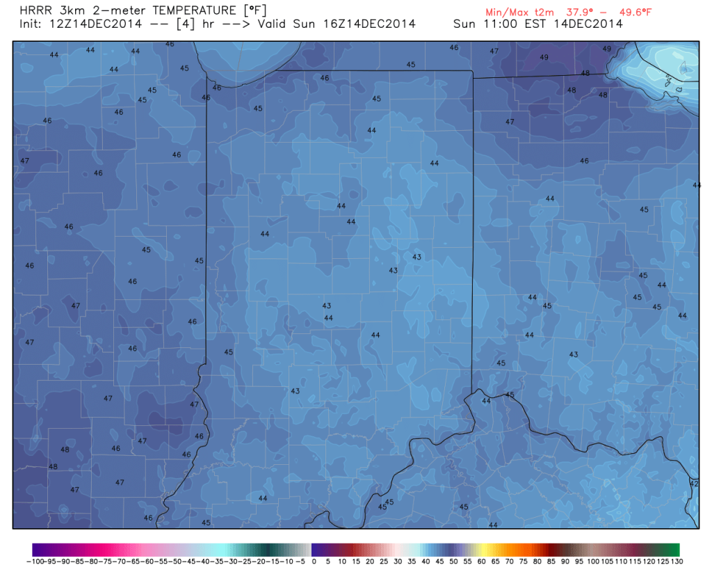
Despite low clouds and areas of drizzle, temperatures will be mild this morning for tailgaters!

Permanent link to this article: https://indywx.com/mild-foggy-with-areas-of-drizzle-for-colts-vs-texans/
-
Filed under 7-Day Outlook, Fog, Forecast, Forecast Discussion, Forecast Models, Heavy Rain, HRRR, Rain, Summer, T-storms, Unseasonably Cool Weather, Unseasonably Warm
-
August 11, 2014
|
Mon.
|
Tue.
|
Wed.
|
Thr.
|
Fri.
|
Sat.
|
Sun.
|
|

|

|

|
|
|
|
|
|
68/ 80
|
60/ 74
|
54/ 76
|
55/ 79
|
58/ 80
|
58/ 82
|
64/ 85
|
Air You Can Wear…We’re awaking to lots of fog and very muggy conditions. Dew points remain in the upper 60s and lower 70s (very oppressive)! A shower or thunderstorm will be possible really at any time today, but most likely this afternoon as the first of two cold fronts drops into the region. Similar to yesterday, locally heavy downpours will certainly be possible with all of the moisture in the air.
A secondary cold front will blow through Tuesday with a continued chance of scattered showers and thunderstorms. We’ll get in on a much cooler and drier air flow Tuesday evening and this will set the stage for a very pleasant rest of the work week, including below normal temperatures into the weekend.
Warming Up; Chance Of Storms…Temperatures will moderate and we’ll introduce showers and thunderstorms into your forecast Sunday. Early thinking on next week suggests a potentially unsettled (stormy) one, but warmer than average.
7-Day Precipitation Outlook:
- 7-Day Rainfall Forecast: 0.50″-1.00″
- 7-Day Snowfall Forecast: 0.00″
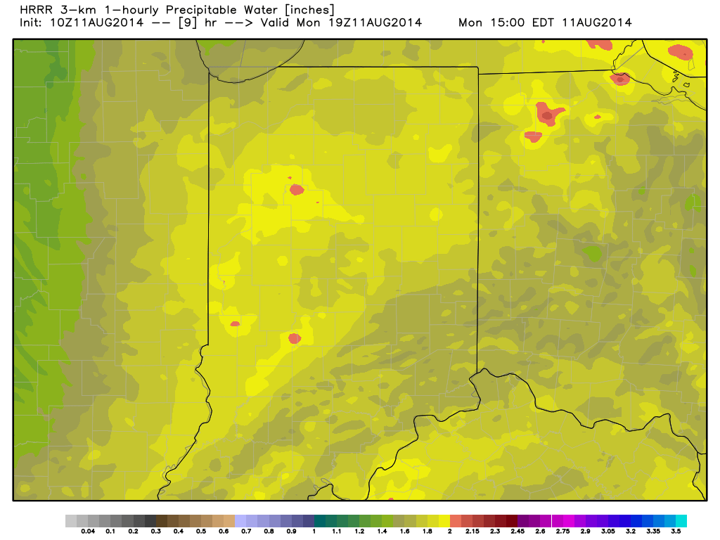
Precipitable water values will once again approach 2″ today and assist in locally torrential downpours around the region.
Permanent link to this article: https://indywx.com/feeling-tropical-now-but-cooler-air-coming/

