Category: Fog

Friday Morning Notebook: Warmer Times This Weekend…

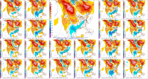
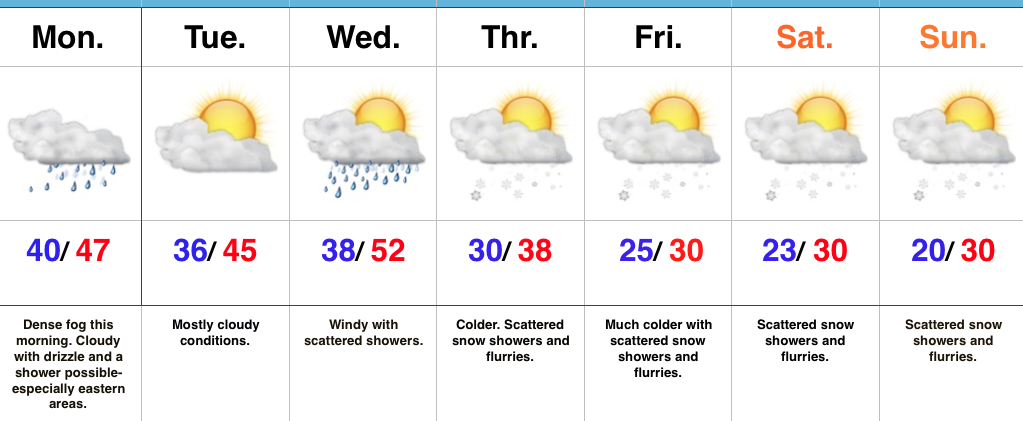
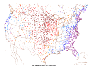
Happy Friday, friends.  We’re still cold this morning, but a look at the change in temperatures compared to 24 hours ago shows the milder trend that will be with us through the upcoming weekend.  Highs today will reach the upper 40s and 55-60 Saturday.

Winds will turn strong and gusty out of the southwest this afternoon, noted by the tightly packed isobars (lines of equal pressure) along with considerable mid and high level clouds.

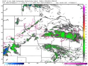
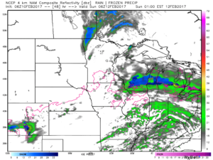
Clouds will lower and thicken Saturday and we may also have to deal with periods of fog, as well.  Showers and drizzle will lift into town as the day progresses, especially by afternoon and evening.

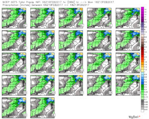
We don’t expect heavy rain this weekend.  In fact, model data continues to really back off on expected totals.  The general consensus is between 0.15″ and 0.25″ across central Indiana.

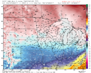
After a mild Saturday, cooler (but not cold) air will ooze into the Ohio Valley Sunday.

Resurgent cold air will blow into town during the middle and latter portions of the upcoming work week.  Highs will return to the 30s with overnight lows in the lower 20s.  We’ll likely add scattered snow showers into the mix as well.

Permanent link to this article: https://indywx.com/friday-morning-notebook-warmer-times-this-weekend/

Foggy Start; Winter Returns…

Screen Shot 2017-01-23 at 7.15.25 AMHighlights:

  • Dense fog this morning
  • Turning much colder this week
  • Scattered snow showers late week

Low Beams On…Dense fog engulfs most of central IN this morning.  Make sure you have the low beams on this morning as you head off to work and school and allow extra time.  A shower is possible at any point today, but particularly across the eastern half of the state.

Our next storm system will push through mid week.  Southwest winds will increase Wednesday and scattered showers will accompany a cold front moving through the state.  Temperatures will fall Wednesday night into Thursday and scattered snow showers will develop.

The theme late in the week and for the weekend will be a wintry one.  Upper level energy will interact with the colder conditions and result in scattered snow showers from time to time into the weekend.  The active northwest flow will remain into next week, as well, and we’ll have to keep a close eye for the prospects of a more “robust” clipper impacting the region just beyond this forecast period.

Upcoming 7-Day Precipitation Forecast:

  • Snowfall: Dusting – 1″
  • Rainfall: 0.10″ – 0.25″

Permanent link to this article: https://indywx.com/foggy-start-winter-returns/

Pleasant; Dry Stretch…

screen-shot-2016-11-04-at-7-40-19-amHighlights:

  • Morning fog and drizzle burns off
  • Pleasant fall weather this weekend
  • Extended dry stretch

Morning Fog Gives Way To Weekend Sunshine…There’s really no reason to waste a lot of pixels in this morning’s 7-day.  High pressure will supply an extended stretch of dry weather, complete with plentiful sunshine.  Morning fog and drizzle will give way to PM sunshine today.  Though cooler than we’ve been, with the exception of seasonable temperatures today, every day through the rest of the forecast period will be above normal.

We’re still eyeing a mid-month pattern transition that should set up a much more active and wintry regime Thanksgiving to Christmas.  Speaking of that, our complete winter outlook was released last weekend.  If you haven’t had an opportunity to see it, click here.

Upcoming 7-Day Precipitation Forecast:

  • Snowfall: 0.00″
  • Rainfall: 0.00″

Permanent link to this article: https://indywx.com/pleasant-dry-stretch/

Scattered Storms; Turning Much Cooler…

Screen Shot 2016-08-18 at 7.46.00 AMHighlights:

  • AM fog burns off today
  • Scattered storms
  • Much cooler air coming

Afternoon And Evening Thunder…Morning fog (some dense) will eventually burn off and give way to a muggy day.  As afternoon heating takes place, scattered evening thunderstorms are a good bet, especially north of Indianapolis.  We’ll repeat this to wrap up the work week Friday.

A cold front will take aim at the region Saturday evening and scattered showers and thunderstorms will accompany this boundary as it moves through.  A few storms could reach strong to severe levels Saturday PM as the front moves through.

Winds will shift to the NW and usher in a much cooler and drier brand of air for the second half of the weekend, continuing into the early portion of next week.  Many will likely be craving fall by early next week coming off multiple mornings with lows in the 50s.

Upcoming 7-Day Precipitation Forecast:

  • Snowfall: 0.00″
  • Rainfall: 0.50″-1.00″

Permanent link to this article: https://indywx.com/scattered-storms-turning-much-cooler/

Thursday Morning Video Update…

Severe potential is there tonight, but how does convection to our west during the day impact the situation downstream (locally) for tonight?  We’re monitoring closely, but for the purpose of…

You must be logged in to view this content. Click Here to become a member of IndyWX.com for full access.  Already a member of IndyWx.com All-Access?  Log-in here.

Permanent link to this article: https://indywx.com/thursday-morning-video-update-3/