Category: Fog

All-Access Client Brief: Plowable Snow Moves In Overnight…

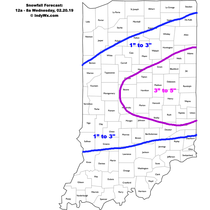
Brief: Heavy Snow & Sleet

Forecaster: McMillan

What: Heavy Snow & Sleet

When: 12a to 8a Wednesday

Temperatures: Upper 20s to lower 30s

Wind: E 15-25 MPH

Blowing/ Drifting: Moderate before mixing with sleet

The setup remains the same as a warm front lifts north during the overnight. Copious amounts of moisture will arrive into central Indiana and with cold air in place, a period of moderate to heavy snow will develop. Timing into the city, itself, should come around, or just before, midnight. While the snow will be of the heavy, wet variety, gusty easterly winds will result in blowing and drifting snow (especially on north-south roadways) before precipitation transitions to sleet. We’ve “beefed” our accumulation forecast up to include a 3″ to 5″ band across east-central Indiana, including Indianapolis, as short-term guidance is indicating a period of significant “forcing” (or lift in the atmosphere) that will lead to heavy snowfall rates before the transition to sleet. A couple of hours with snowfall rates in excess of 1″ per hour will likely be observed in that 1a to 3a window. Precipitation will transition to sleet and a period of freezing rain between 3a and 5a from south to north, before turning to all rain in the city before sunrise. Further north, a transition to rain won’t be noticed until after 8a, but the majority of precipitation will likely be over with by that point (just lingering drizzle and fog).

Confidence: High

Permanent link to this article: https://indywx.com/all-access-client-brief-plowable-snow-moves-in-overnight/

Heavy Rain Arrives Tonight; Accumulating Snow Band May Setup Shop For Portions Of The Area Tuesday…

A busy pattern continues with heavy rain tonight. Attention then shifts to the potential of a band of accumulating snow, associated with a vigorous piece of upper level energy Tuesday…

You must be logged in to view this content. Click Here to become a member of IndyWX.com for full access.  Already a member of IndyWx.com All-Access?  Log-in here.

Permanent link to this article: https://indywx.com/heavy-rain-arrives-tonight-accumulating-snow-band-may-setup-shop-for-portions-of-the-area-tuesday/

Period Of Severe Cold Arrives Early-Mid Week…

[

You must be logged in to view this content. Click Here to become a member of IndyWX.com for full access.  Already a member of IndyWx.com All-Access?  Log-in here.

Permanent link to this article: https://indywx.com/period-of-severe-cold-arrives-early-mid-week/

Cold Pattern With Multiple Opportunities For Snow On The Horizon…

It may be briefly milder now, but we’re locked into an overall cold pattern for the foreseeable future.  There are multiple opportunities for snow to go along with the cold,…

You must be logged in to view this content. Click Here to become a member of IndyWX.com for full access.  Already a member of IndyWx.com All-Access?  Log-in here.

Permanent link to this article: https://indywx.com/cold-pattern-with-multiple-opportunities-for-snow-on-the-horizon/

Quiet Period Of Weather Into Early Next Week…

Although we’re dealing with areas of drizzle, low clouds, and fog this morning, a relatively quiet period of weather is ahead as we put a wrap on the week and head through the weekend.  At one time what I thought would be a more significant storm system and associated eastern wintry threat won’t come to fruition.  While the eastern seaboard will deal with rain Friday into Saturday, we should remain free of any significant precipitation here on the home front.

Weak high pressure will keep us dry with increasing sunshine through the weekend.

Our next storm system will arrive as we open up next week and we’ll forecast increasing rain chances next Monday.  From this distance, moisture return isn’t terribly impressive and rainfall amounts should remain generally in the 0.25″ to 0.75″ range.

Colder air will follow behind this storm system with more authority and those wishing and hoping for legitimate wintry conditions may finally have their wish as we get closer to mid month.  Speaking of cold and wintry times, we’ll have more on our updated long range thoughts later this week.

Permanent link to this article: https://indywx.com/quiet-period-of-weather-into-early-next-week/