Updated 10.07.22 @ 7:48a
You must be logged in to view this content. Click Here to become a member of IndyWX.com for full access. Already a member of IndyWx.com All-Access? Log-in here.

Oct 07
Updated 10.07.22 @ 7:48a
You must be logged in to view this content. Click Here to become a member of IndyWX.com for full access. Already a member of IndyWx.com All-Access? Log-in here.
Permanent link to this article: https://indywx.com/video-first-widespread-frost-and-freeze-this-weekend-tracking-a-stronger-storm-system-late-next-week/
Oct 31
Updated 10.31.21 @ 3:06p
First and foremost, here’s wishing you and your family a very happy, safe, and fun Halloween. Late October can sure deliver “tricks” in the weather department around these parts, but thankfully we’re going to be treated to very pleasant conditions this year as the kiddos hit the streets this evening.
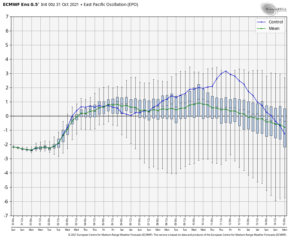
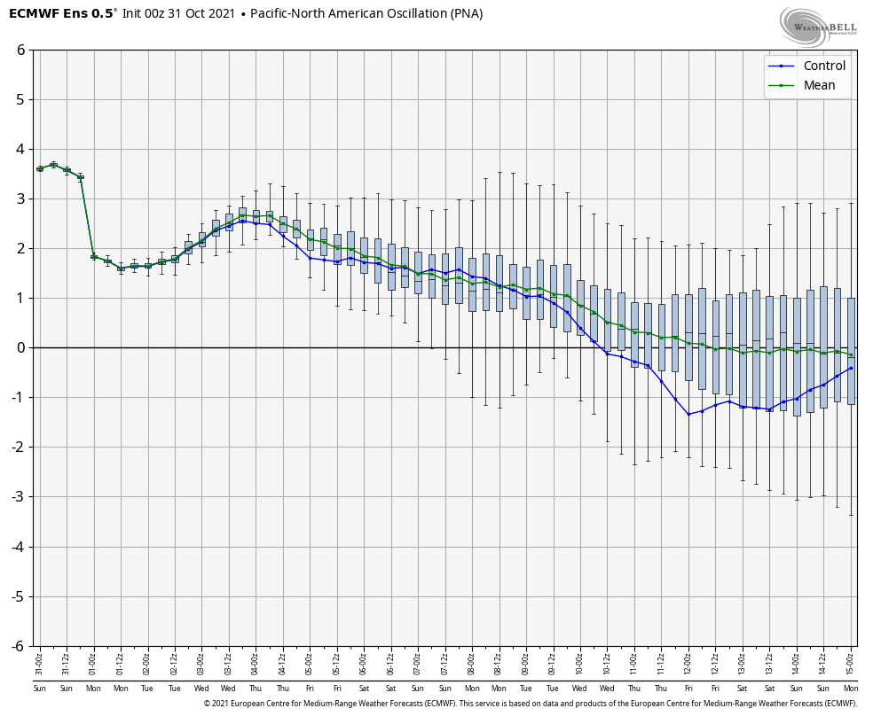
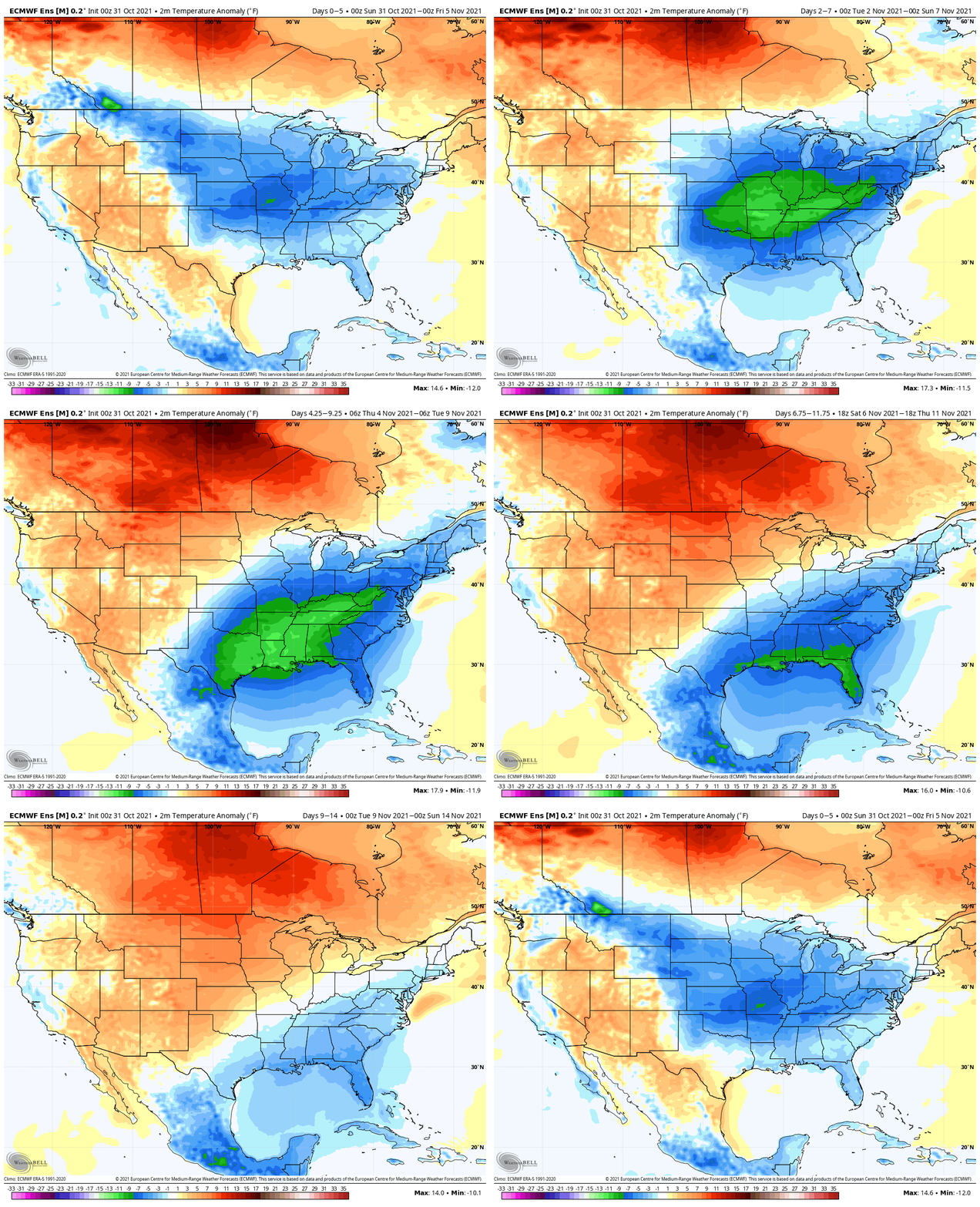
As we look ahead to November, unseasonably chilly air will settle into the East through the week ahead. The MJO is not a factor presently and is forecast to remain in the “null phase” through the upcoming couple weeks (at least). As such, we’ll lean heavier on the EPO/ PNA tandem to drive the pattern. For a moment, these teleconnections will help power widespread unseasonably chilly air as they are aligned in such a manner (- EPO and +PNA), but as we head towards Week 2, note how both teleconnections head towards warmer phases.


Ensemble guidance sees the chilly short-term pattern moderating in the Week 2 time period and we agree.

Overall, the upcoming (10) days should also feature a much drier regime than what we’ve seen over the past few weeks. Rainfall is forecast below normal through the first 1/3 of November.

While the growing season will come to an end in the week ahead and we continue to believe this chilly short-term pattern is a “hint” to what awaits towards the 2nd half of November, that PNA/ EPO combo suggests we’re not quite ready for the more sustained, and potentially dramatic, pattern change just yet…
Permanent link to this article: https://indywx.com/november-opens-with-a-hint-of-what-may-be-lurking-but-pattern-likely-not-ready-to-lock-in-just-yet/
Oct 26
Updated 10.26.21 @ 7:20a
You must be logged in to view this content. Click Here to become a member of IndyWX.com for full access. Already a member of IndyWx.com All-Access? Log-in here.
Permanent link to this article: https://indywx.com/video-frosty-start-wednesday-next-system-awaits/
Oct 17
Updated 10.17.21 @ 11:10a
You must be logged in to view this content. Click Here to become a member of IndyWX.com for full access. Already a member of IndyWx.com All-Access? Log-in here.
Permanent link to this article: https://indywx.com/video-quiet-open-to-the-week-next-system-arrives-thursday-followed-by-coolest-air-so-far-this-fall/
Oct 14
You must be logged in to view this content. Click Here to become a member of IndyWX.com for full access. Already a member of IndyWx.com All-Access? Log-in here.
Permanent link to this article: https://indywx.com/video-sharply-colder-air-flows-into-the-region-to-close-the-week-a-look-at-how-the-epo-impacts-our-weather/