You must be logged in to view this content. Click Here to become a member of IndyWX.com for full access. Already a member of IndyWx.com All-Access? Log-in here.
Category: Fall Foliage
Permanent link to this article: https://indywx.com/classic-fall-feel-inbound/
Oct 15
Falling Temperatures Today; Dry Weather Returns…
 Highlights:
- Temperatures fall through the day
- Sunshine returns this week
- Pleasant stretch of weather ahead
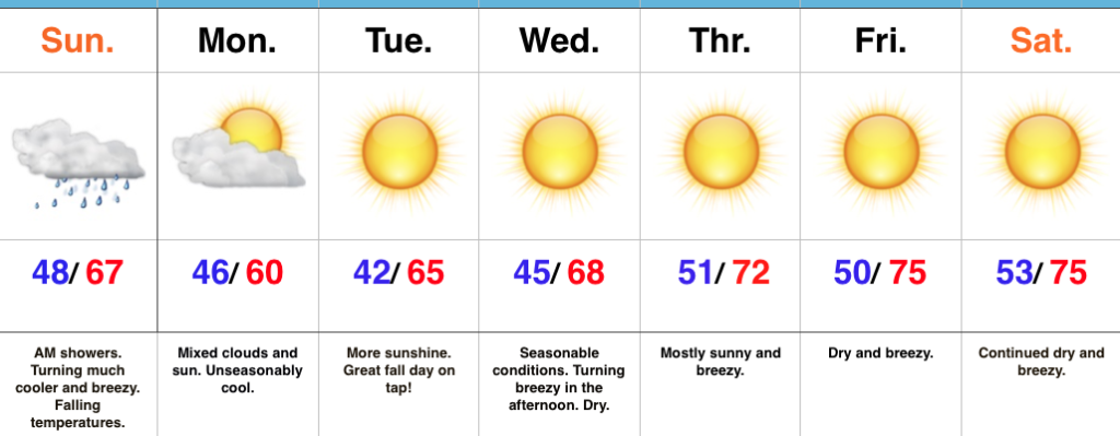
Jackets And Sweaters Required By This Afternoon…A cold front will continue to march east this morning and this will push a broken band of showers east through the state. Rainfall amounts won’t be significant, but will be enough to be a nuisance on the way to church or brunch this morning. This afternoon, we’ll notice an increasingly gusty breeze and falling temperatures. While it’s mild this morning, it’ll feel much cooler as we progress through the afternoon and evening hours. Jackets and sweaters will be required!
High pressure will settle overhead for the upcoming week and this will lead to an extended period of dry, pleasant weather. Temperatures will moderate from seasonably cool early-week to unseasonably mild by late-week. As expected, the late September and early October warmth (particularly warm overnight lows) really stunted our fall foliage this year. That said, the cool, calm nights ahead this week will be sufficient enough to at least ignite some of the remaining leaves on trees for what should be a couple weeks of “decent” color ahead.
Longer term, there are big goings on behind the scenes that will help drive a dramatically different weather pattern to wrap up the month of October and head into November. Heads up to the parents out there, you may want to nudge the kiddos into picking a warm costume this Halloween…
Upcoming 7-Day Precipitation Forecast:
- Snowfall: 0.00″
- Rainfall: 0.10″ – 0.25″
Permanent link to this article: https://indywx.com/falling-temperatures-today-dry-weather-returns/
Sep 28
Finally Feeling Like Fall This Weekend…
 Highlights:
- Cooler start
- Reinforcing cool air arrives Friday evening
- Warming back up next week
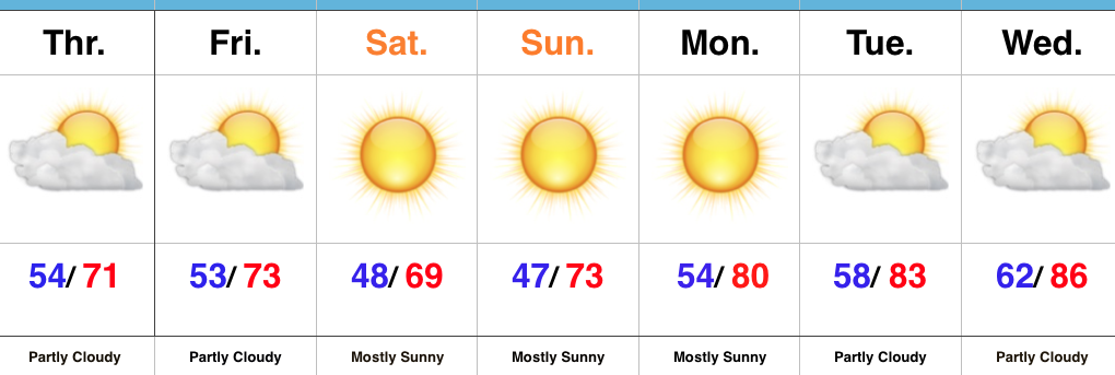
This Is More Like It…Cooler air worked into central Indiana overnight behind a cold front. If you ask us, a step out the door this morning feels much better than the past week (we’re ready for fall, y’all)! A reinforcing push of cool air will blow into town Friday evening and result in Saturday being the coolest day of the weekend with most remaining in the 60s for afternoon highs.
As we open up the new work week, our air flow will back around to the south and result in a new warming trend. An expanding ridge of high pressure will lead to continued dry conditions next week, along with unseasonably warm to hot temperatures.
Looking longer-term, there’s really no change in sight in the overall weather pattern through at least early October. That said, there are indications more significant changes loom towards mid-month that could result in more of an impactful shift to cooler times by the second half of the month (warm weather fans, keep in mind the other shoe has to drop sooner rather than later ;-)). As far as precipitation goes, while the short-term doesn’t offer any hope for dry weather relief, we’re confident of a big flip towards a wet pattern by late autumn and winter. Hang in there!
Fall Foliage: The early season cool air we experienced in late August and first half of September ignited early fall foliage across central Indiana. Unfortunately, the recent heat and expected warmer than average pattern through early October will really stunt that fall color change. As things stand now, this fall isn’t shaping up to be one of the better color seasons across the area.
Upcoming 7-Day Precipitation Forecast:
- Snowfall: 0.00″
- Rainfall: 0.00″
Permanent link to this article: https://indywx.com/finally-feeling-like-fall-this-weekend/
Sep 24
Changes Brewing…
 Highlights:
- Dry weekend
- Rain arrives late Sunday night/ early Monday
- Feeling much more like fall next week
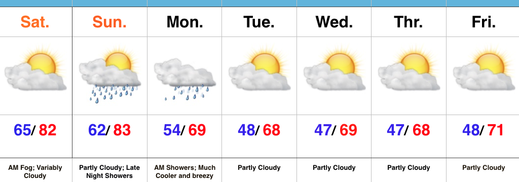
Heat Is Limited…Despite areas of low clouds and fog, we’re looking at a mostly dry weekend. A large temperature contrast will be noted from northeast parts of the state to the southwest corner this afternoon as a backdoor cold front continues to press south. Showers will build in late Sunday night (well after most folks head to bed). This is in association with an autumn cold front that will sweep through the region Monday morning. Showers will continue through the morning hours before a northwest wind shift helps usher in a drier and much cooler air mass Monday afternoon. You’ll want to reach for the jacket and your favorite pumpkin beverage Monday evening…
Unseasonably cool air will be with us for the balance of the upcoming work week, along with a northwest flow. It’ll feel much more like fall and the cooler, drier air mass will really help ignite the fall color change across central IN.
Upcoming 7-Day Precipitation Forecast:
- Snowfall: 0.00″
- Rainfall: 0.25″ – 0.50″
Permanent link to this article: https://indywx.com/changes-brewing-2/
Oct 25
Brilliant Fall Foliage…
As we continue to enjoy peak weekend for fall foliage across central IN, we wanted to share a few photos we snapped out and about in the Zionsville and Eagle Creek area earlier today. Perhaps it was the wet summer followed by the extended stretch of dry, sunny weather late summer into the fall that has led to such vibrant color across the immediate region- some of the best we’ve seen in years. Regardless, be sure to enjoy as the mid week rain storm and very windy conditions that follow will likely take down a lot of the leaves later this week.
Permanent link to this article: https://indywx.com/brilliant-fall-foliage/


