You must be logged in to view this content. Click Here to become a member of IndyWX.com for full access. Already a member of IndyWx.com All-Access? Log-in here.
Updated 03.03.25 @ 7:40a We’re moving into a very busy pattern over the upcoming week to 10 days, and this likely will set the overall tone for March, as a…
You must be logged in to view this content. Click Here to become a member of IndyWX.com for full access. Already a member of IndyWx.com All-Access? Log-in here.
Updated 02.28.25 @ 6a As we get set to rumble into meteorological spring (March 1 through May 31), a much more active weather pattern looms. After a couple of drier…
You must be logged in to view this content. Click Here to become a member of IndyWX.com for full access. Already a member of IndyWx.com All-Access? Log-in here.
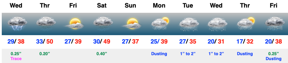
Mostly cloudy and cold conditions this morning will give way to a thickening and lowering cloud canopy through the afternoon and precipitation by late afternoon and into the evening (overspreading the region from southwest to northeast). Even a few rumbles of thunder can be expected tonight and freezing rain concerns remain across the northern tier. Here on the home front, only trace amounts (light glaze north-central) of ice can be expected.
This is only the beginning to a very active time of things over the upcoming 6-10 days.
Updated 01.28.25 @ 6a While the pattern in the short-term will allow us to catch our breath in what’s been a cold and snowy January, there’s mounting evidence that the…
You must be logged in to view this content. Click Here to become a member of IndyWX.com for full access. Already a member of IndyWx.com All-Access? Log-in here.