Category: EPO

Negative NAO Set To Present Mid-Month Headaches…

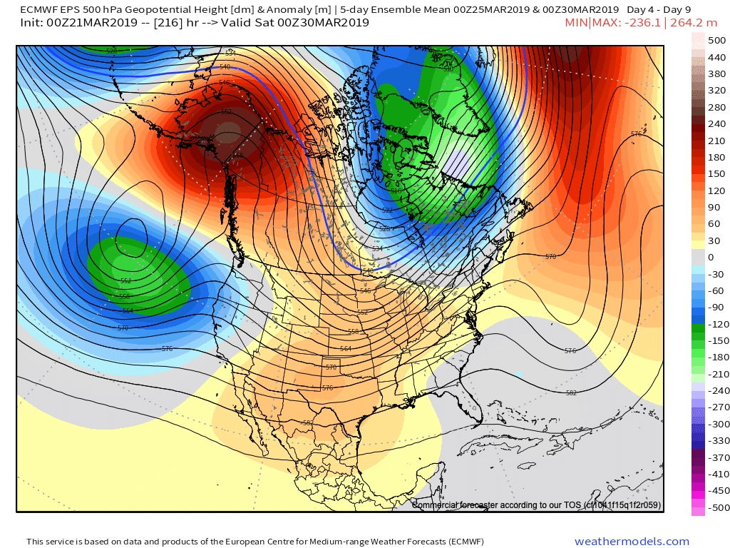
In case you missed it, you can find our April Outlook here. We want to ensure we’re very transparent and never shy away from the products we put out there. With that said, as difficult as it can be at times, it’s critically important that adjustments are made when necessary. The fact of the matter is that medium and long range modeling has had a glaring error since late winter and early spring. First, it was the EPO and now the NAO that appear to create all sorts of chaos in the medium to longer range period.

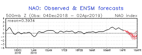
We note the NAO (or North Atlantic Oscillation) is set to drop to as negative of levels since January and some data would suggest we’re going to go even lower.

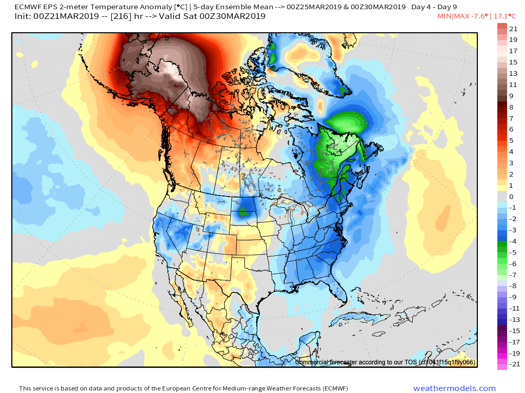
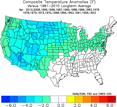
A negative NAO in April would “normally” lead to this kind of temperature pattern:

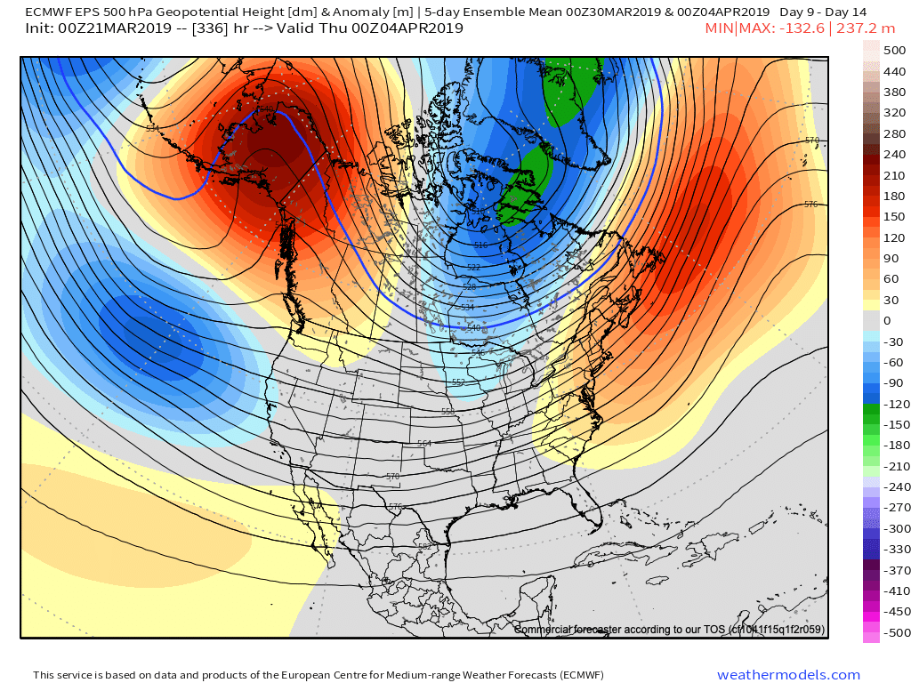
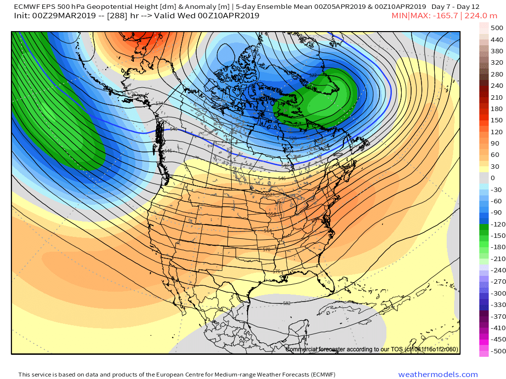
The normally reliable European model had this kind of pattern for mid-April only a couple of days ago:

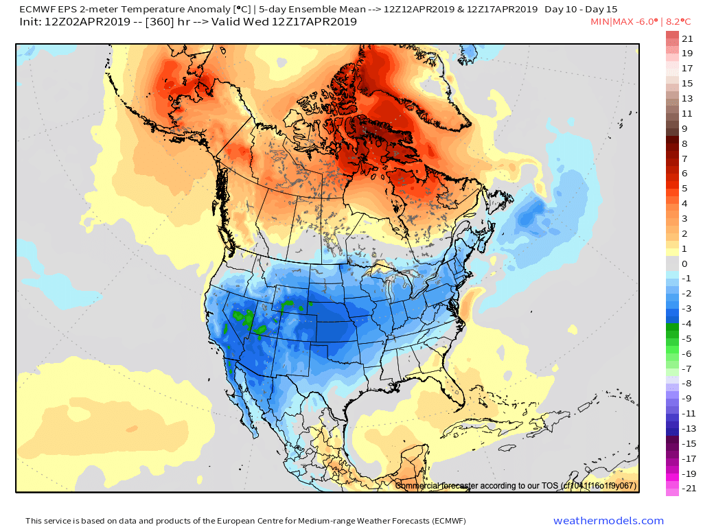
Today, we’re talking about this kind of pattern for the exact same time period:

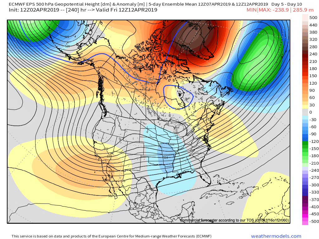
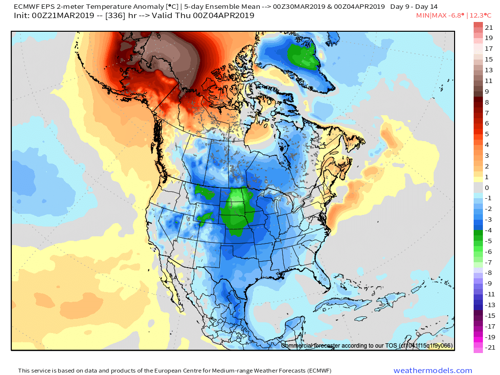
That’s a “night and day” difference. The reason? The model is beginning to catch on to the significant negative NAO developing. Accordingly, latest data delivers incredible high latitude blocking and subsequent cooler anomalies across a large portion of the Lower 48 for the mid-month period. (Note how close the below temperature pattern in the Day 10-15 time frame is to the analog a few images above. Remarkable stuff).

This time of year won’t result in sustained colder than normal conditions and transient warmth will make itself felt from time to time, but it’s a far cry from the sustained warmth originally expected for mid-April.

As we reflect back to the struggles long range models had with the negative EPO and now flip the page forward to the negative NAO problems, it certainly leads to lower than normal confidence in long range data and leads to a “cause for pause” as we put together monthly/ seasonal data into the upcoming late spring and summer months. Transitional seasons (spring and fall) can always be fickle, but some of the issues with the drivers this spring are in a different league.

Enjoy the “spring fling” that will develop late this week and weekend. The warmest air of the year is still on deck.

Longer term, well sometimes you have to throw ideas that have been made of long hours and hard work in the trash and start over from scratch…

Permanent link to this article: https://indywx.com/negative-nao-set-to-present-mid-month-headaches/

Long Range Video Update: April Opens Stormy And Colder Than Normal…

It’s quiet now, but a very active and stormy pattern will get underway as we head into the weekend. This busy weather pattern will continue to rule the day into…

You must be logged in to view this content. Click Here to become a member of IndyWX.com for full access.  Already a member of IndyWx.com All-Access?  Log-in here.

Permanent link to this article: https://indywx.com/long-range-video-update-april-opens-stormy-and-colder-than-normal/

More On The Late March-Early April Pattern And Reviewing The NEW JMA Weeklies…

As we look ahead, a persistent western Canada/ Alaska ridge continues to show up on the medium to long range data. The downstream implications are for cooler than normal temperatures, overall, across the eastern and central portions of the country into early April.

Upper air pattern- Days 4-9
Surface temperature anomalies- Days 4-9
Upper air pattern- Days 9-14
Surface temperature anomalies- Days 9-14

Given the time of the year (and pattern), cool won’t rule the entire period. It’s just that the cold will “out do” the transient warmth in between storm systems over the next couple of weeks.

When we look at the teleconnections (combo of negative EPO and neutral to slightly positive PNA is ruling the day for now), they support the lingering chill into early-April.

However, as we turn the page from early-April to mid-April, the idea here is that an eastern ridge will begin to expand west with more “umph” and eventually lead to warmth overwhelming the pattern. We aren’t budging from the original idea of a warmer than normal April by month’s end. It sure appears as if the NEW JMA Weeklies are catching onto this idea.

Weeks 3-4 (mid April) forecast upper air pattern.

From a precipitation perspective, the majority of medium and long range model data does show a return of wetter times (relative to normal) as we move into April, including an active storm track. The beginning of this overall shift in the pattern back towards wetter than normal conditions will begin early next week.

We’ll recap our latest short-term thinking, including an update on the NEW European Weeklies that will arrive this evening later tonight in a video update.

In the meantime, make it a fantastic Thursday- and happy tip off to March Madness!

Permanent link to this article: https://indywx.com/more-on-the-late-march-early-april-pattern-and-reviewing-the-new-jma-weeklies/

Tuesday Morning Video: Reason To “Tap The Brakes” On Late Month Warm-Up?

You must be logged in to view this content. Click Here to become a member of IndyWX.com for full access.  Already a member of IndyWx.com All-Access?  Log-in here.

Permanent link to this article: https://indywx.com/tuesday-morning-video-reason-to-tap-the-breaks-on-late-month-warm-up/

Long Range Video Update: Changeable Pattern For The 2nd Half Of March Into April…

You must be logged in to view this content. Click Here to become a member of IndyWX.com for full access.  Already a member of IndyWx.com All-Access?  Log-in here.

Permanent link to this article: https://indywx.com/long-range-video-update-changeable-pattern-for-the-2nd-half-of-march-into-april/