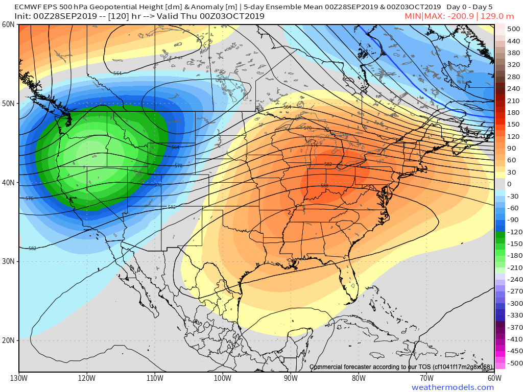
A hot start to the work week awaits! An expansive upper level ridge will dominate the 2nd half of the weekend into the first couple days of the work week.
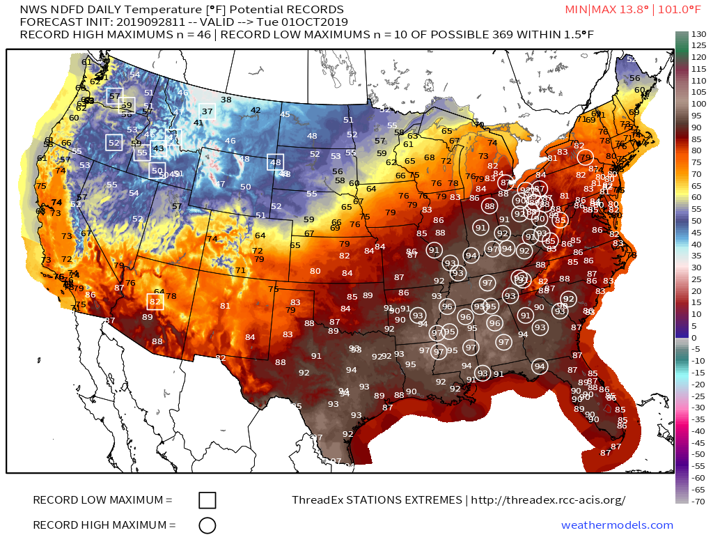
Near record to record heat will surge north into the Ohio Valley through the early week stretch. The dry to droughty Deep South continues to bake through the period and won’t see nearly the relief we’ll enjoy later on in the period…
Changes loom by midweek as a cold front sinks south into the Ohio Valley. While we’re not overly excited about beneficial widespread rainfall, significant cooling will take place for the 2nd half of the work week and next weekend.
Temperatures will actually trend below average Thursday through the weekend with highs in the 60s and lows in the 40s to lower 50s.
As we look ahead, we’ll keep close tabs on the MJO and EPO for clues of the overall October pattern. Not surprisingly, the signals contradict themselves. The MJO supports above normal temperatures returning while the EPO favors seasonable to chillier than average temperatures. Stay tuned…
Our official October Outlook will be online over the weekend…
I want to give a couple examples of significant conflicting signals- both short and long-term. The end result is a situation where long range, climate, and seasonal models are likely to have a very tough time not only in the medium to long range (2-4 week period), but thinking seasonally, as well (winter and next spring).
Short-term
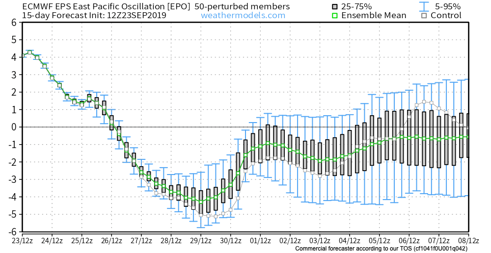
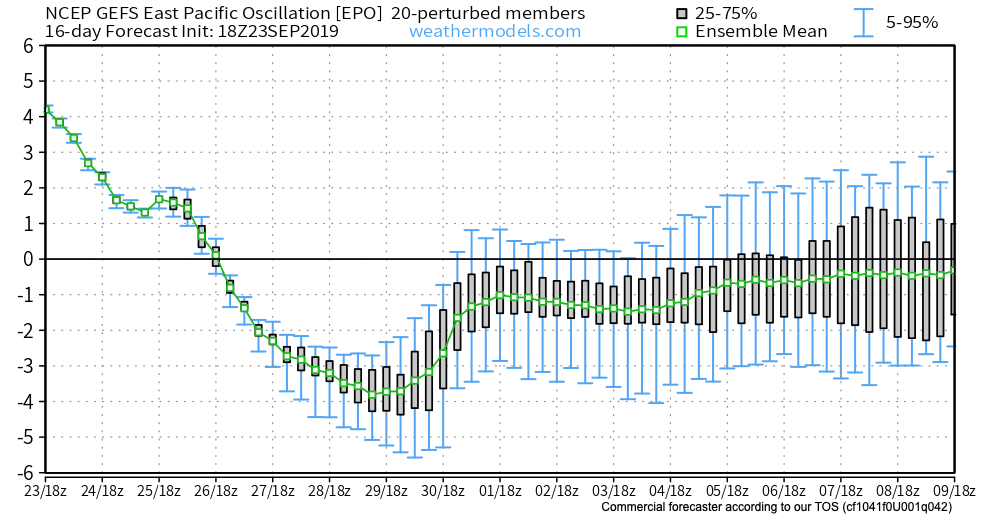
To start, let’s look at the EPO. While strongly positive at present, both the EPS and GEFS pictured below take the EPO, or East Pacific Oscillation, negative in the coming couple of weeks.
A negative EPO pattern favors a trough across the eastern portion of the country, especially here in our neck of the woods, with western ridging.
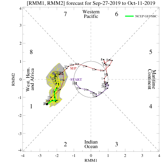
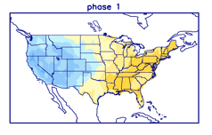
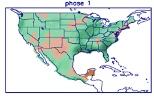
All well and good, right? WRONG. The MJO, or Madden Julian Oscillation, is forecast to stall out into early October in Phase 1.
This time of year, Phase 1 argues strongly for eastern ridging and well above normal warmth while the western portion of the country can experience early wintry conditions.
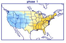
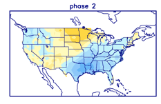
Talk about contradiction! That’s what makes weather so fun and fascinating. Expect to be humbled often and to always learn! At various times of the year, select teleconnections can mean a lot more than other times of the year. For example, during the summer and fall, we lean heavily on the EPO, PNA, and MJO (if amplified). During the winter and spring, it’s important to take into account what the AO and NAO have to say. It’s important to know when to “pick and choose” when to use particular teleconnections… Furthermore, the various MJO phases (1-8) mean drastically different things at different times of the year. While lovers of chilly fall conditions have grown to hate an amplified Phase 1, they have to love it come winter (shown below). Just look at that difference!
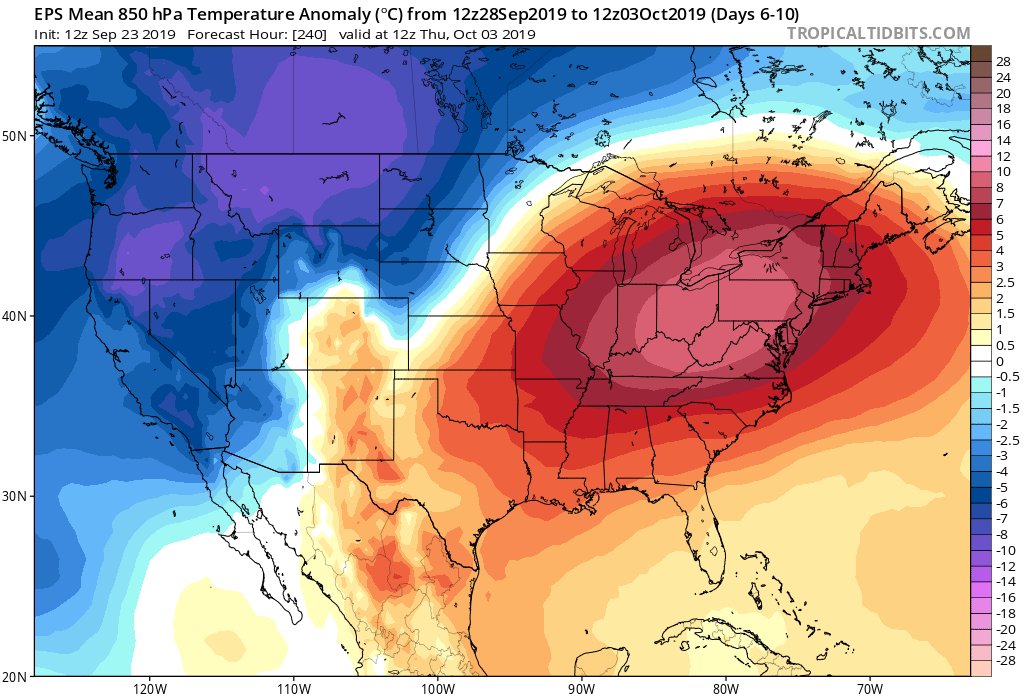
Before jumping ahead to another example of “contradicting signals,” we’re confident the amplified MJO Phase 1 will carry the day through the short to medium range period. Note the strong agreement between the EPS and GEFS below with respect to temperature anomalies in the 6-10 day period.
With that said, there will be challenges within (the big difference as early as this weekend between the GFS and European operational data). A lot of that has to do with the “fight” between the EPO and MJO to take control.
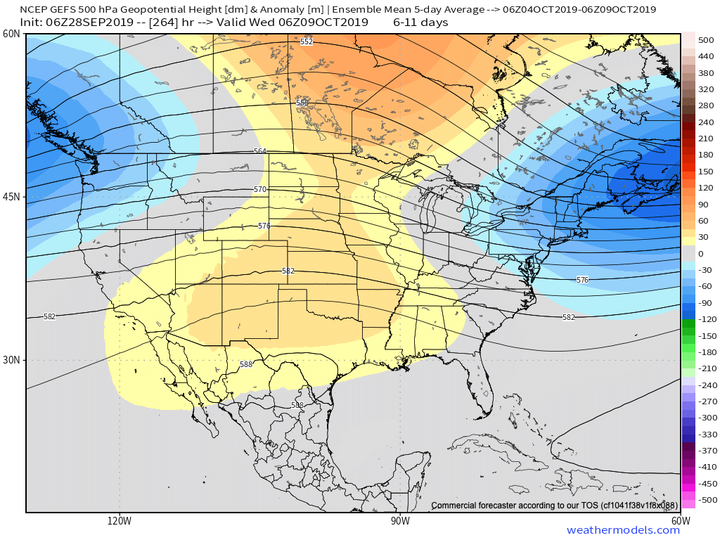
As all of this unfolds across the East, the west will begin to cash in on early winter. Well below average cold and snowy conditions will begin to make headlines over the weekend into next week across not only the Rockies, but some of the low ground, as well. Should the MJO swing into Phase 2 (and I think it will towards mid-Oct), then watch out. We’ll be looking at a rather significant shift towards a much colder feel- and it’ll sting even more so with the late season heat over the better part of the next couple of weeks.
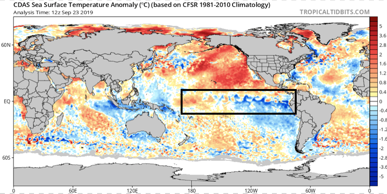
Flipping the page to winter (remember, our prelim. winter outlook will be posted later this week) and the contradiction continues. Upon looking at the current SST configuration, one could easily argue we’re talking about a La Nina winter unfolding ahead.
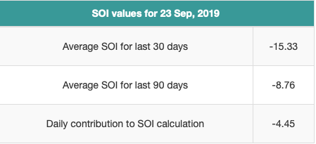
Meanwhile, the current SOI would suggest we’re in a moderate El Nino.
If you think this can’t wreck havoc even on the short-term forecast pattern, think again…
To close, while the conflicting data can create headaches at times, it’s more fascinating than ever trying to sift through the data and build our forecast(s). It’d be wise to expect more wild swings ahead- leave it to us to try and minimize the impacts of those swings in your day-to-day personal and professional lives. Accordingly, it’s also ultra-important to factor in additional items, such as solar and PDO into the equation for the upcoming winter.
Speaking of, without giving too much away, if I’m a winter weather fan (and I am), I wouldn’t worry in the least about the current warmth… 😉
You must be logged in to view this content. Click Here to become a member of IndyWX.com for full access. Already a member of IndyWx.com All-Access? Log-in here.
Lovers of fall weather sure don’t want to see Phases 8 or 1 of the MJO in September and October. These are flat-out blow torch phases across the eastern half of the country and sure enough, that’s what we’re forecasting over the better part of the next couple of weeks. With an amplified MJO, we put more stock into this signal than others (EPO, for example) in building out our Weeks 2-3 forecast.
This is not only a warm signal for our immediate region, but a wetter signal as well.
It should be no surprise to see the models paint a very warm picture over the next couple of weeks with this MJO “stalling” in Phase 1. This will lead to a persistent eastern ridge (any cooler air will be very transitional) along with western cold and early snow.
Although things will turn more active, locally, the wettest anomalies should be centered just off to the west and north of our immediate region through the balance of the upcoming 14 days.
While we’ll continue to deal with “bonus” summer-like conditions, the overall pattern from a bigger picture is one that shows fall and winter are, indeed, just around the corner… Note how the snow cover is expected to expand over the next couple of weeks west and north.
This is worth keeping an eye on. With the MJO showing a tendency to become more amplified, it’s only a matter of time before we swing into the much colder Phase 2 (thinking we need to watch mid-October). Phase 2 in and of itself will be a rather abrupt shift given just how warm we’ll be the next couple of weeks, but when you add in the fact that we’ll likely be looking at a fast start to the snow season, it may come as even more of a shock as the air mass won’t be able to “modify” on its journey southeast.
You must be logged in to view this content. Click Here to become a member of IndyWX.com for full access. Already a member of IndyWx.com All-Access? Log-in here.