Category: EPO

MJO/ EPO Telling Of Where The Pattern Is Heading To Close September & Open October?

The short-term period will continue to be dominated by unseasonably warm and dry weather. While we’ll notice a drier air mass (lower humidity) in place the next couple of days, temperatures will remain much warmer than where we should be in mid to late September.

As we close out the month and head into early October, there’s opportunity for a cooler change and we can look to the MJO and EPO for these clues.

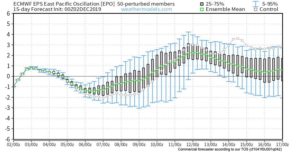
Let’s start with the EPO. The GEFS has been leading the way on the negative transition late September for some time now. The EPS is now trending more strongly negative as of the past couple of days. This argues for a cooler than normal period of weather as we put a bow on September and open October.

(The strongly positive EPO will promote more well above normal warmth in the short to medium term period).

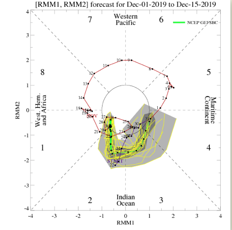
The MJO is becoming more amplified and the result is that we can add another “tool to the belt” moving forward in determining the overall direction of the longer range pattern.


Phase 8 argues for widespread warmth, but as we transition from Phase 1 into Phase 2 (easy to see that’s where the MJO wants to head), cooler air swings into the East/ South.

That transition may also result in needed moisture. Note the wetter period that develops during the movement from Phase 1-2.

Speaking of moisture, Sunday appears to offer up the best chance of widespread, organized rain/ storms we’ve seen month-to-date. Models are keying in on the potential of 0.50″ to 1″ (fingers crossed) as a cold front moves into the region.

The CFSv2 is following the plan outlined above- transitioning towards a wetter and eventually cooler pattern Weeks 2-3.

Sept. 17th-27th temperature anomalies
Sept. 27th-Oct. 7th temperature anomalies
Sept 17th-27th precipitation anomalies

Permanent link to this article: https://indywx.com/mjo-epo-telling-of-where-the-pattern-is-heading-to-close-september-open-october/

VIDEO: Generally Quiet Pattern This Week; Late Month Thoughts…

You must be logged in to view this content. Click Here to become a member of IndyWX.com for full access.  Already a member of IndyWx.com All-Access?  Log-in here.

Permanent link to this article: https://indywx.com/video-generally-quiet-pattern-this-week-late-month-thoughts/

Interesting Test Case In Front Of Us: Euro Vs. Everyone Else…

As we look ahead to late September, there’s a battle beginning to take place in model land. When we pull back the curtain, we note the GEFS and EPS handle the evolution of the EPO in two totally different manners in the Week 2 time period.

The GEFS begins to tank the EPO, suggesting cooler times are ahead to close September.
The EPS maintains a positive EPO and associated much warmer pattern to close September.

Our stand on the evolution of the pattern remains unchanged: that much cooler times will return as we get set to wrap up the month and head into early October. Updated data, aside from the European, suggests we’re on the right track with that train of thought.

JMA Weeklies- Week 2

CFSv2- Week 2

GEFS- Week 2

Permanent link to this article: https://indywx.com/interesting-test-case-in-front-of-us-euro-vs-everyone-else/

Looking Ahead To The 2nd Half Of September…

A gorgeous mid September day awaits, with plentiful sunshine and unseasonable warmth. A cold front sits off to our northwest. Meanwhile, a disturbed area of weather in the Bahamas will be monitored for the potential of further development late week into next week as it eventually moves into the Gulf of Mexico.

We’ll remain quiet across central Indiana today, but notice a flare up of thunderstorm activity across northern parts of the state tonight. Some of this shower and thunderstorm activity will drift south into central Indiana early Wednesday, but “widely scattered” will be the appropriate word to describe the coverage and many won’t see a drop of rain.

Scattered storms will fire up across northern IN tonight. (Forecast radar midnight Wednesday).

Scattered showers and thunderstorms will remain in the forecast Thursday into Friday before a cold front sweeps through the area. This front will lead to lower humidity as we head into the weekend, but temperatures will remain above average. While some will make it through the rest of the week without seeing a drop of rain, others may pick up 0.25″ to 0.50″ with those scattered downpours.

As we look ahead to the 2nd half of September, a warmer to much warmer than average pattern is anticipated to continue. A big reason behind the warmth is the predominantly positive EPO.

A true blow torch of a pattern will result into the late month stretch. Eventually, we should see a pull back of the heights into the NW and western Canada and more of an eastern trough showing up in the means, but this isn’t likely to take place until the last couple of days of this month or early October. Until then, expect an overall summer-like feel.

Permanent link to this article: https://indywx.com/looking-ahead-to-the-2nd-half-of-september/

A Teleconnection Tale…

Before we display the mean upper level pattern ahead over the next couple weeks, let’s look at some of the various teleconnections to gain some insight behind what’s driving the overall pattern.

EPO- primarily positive to strongly positive (warm signal).

WPO- primarily positive to strongly positive (warm signal).

MJO- heading into Phase 6 with a look like it wants to rumble into Phase 7. This is a warm signal this time of year.

With the warm signals above, it should come as no surprise of the next couple weeks offering up a predominant eastern ridge.

Days 6-10

Days 10-14

While a couple of weak cold fronts may lead to somewhat cooler air briefly, the balance of the next couple of weeks looks to offer up much more in the way of summer-like heat and well above normal warmth. It should also be noted that the overall pattern looks like a dry one over the next 10-14 days, as well.

Don’t put away that swim suit just yet!

Permanent link to this article: https://indywx.com/a-teleconnection-tale/