Updated 01.14.21 @ 6:52p
You must be logged in to view this content. Click Here to become a member of IndyWX.com for full access. Already a member of IndyWx.com All-Access? Log-in here.

Jan 14
Updated 01.14.21 @ 6:52p
You must be logged in to view this content. Click Here to become a member of IndyWX.com for full access. Already a member of IndyWx.com All-Access? Log-in here.
Permanent link to this article: https://indywx.com/video-short-and-long-range-update-as-we-head-into-at-times-a-snowy-weekend-and-get-set-to-traverse-the-2nd-half-of-jan-open-feb/
Jan 12
Updated 01.12.21 @ 8:08a
Finally we can breathe a sigh of relief as the seemingly unending low cloud deck erodes and gives way to increasing sunshine today. Along with a return of the sun will be a moderating trend in the temperature department. Expect highs in the low 40s today and mid 40s Wednesday and Thursday as a southwesterly flow develops ahead of Friday’s cold front.


The cold front, itself, will swing through central Indiana late Thursday night and early Friday morning. While we still think this will be a mostly dry FROPA (frontal passage), models are becoming more robust with a “bowling ball” of an upper level low pressure system over the weekend.
Note how the upper low becomes almost cut off from the primary steering flow for a time Saturday across the Great Lakes region. Additional “spokes of energy” (upper level disturbances) will pivot south of the primary cut off low across the Ohio Valley Friday night through Sunday afternoon. This will help lead to enhanced periods of snow and snow showers throughout the weekend.
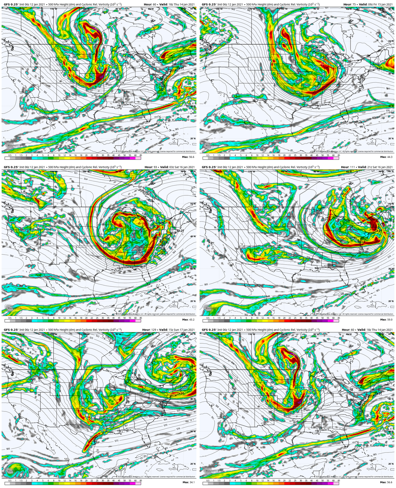
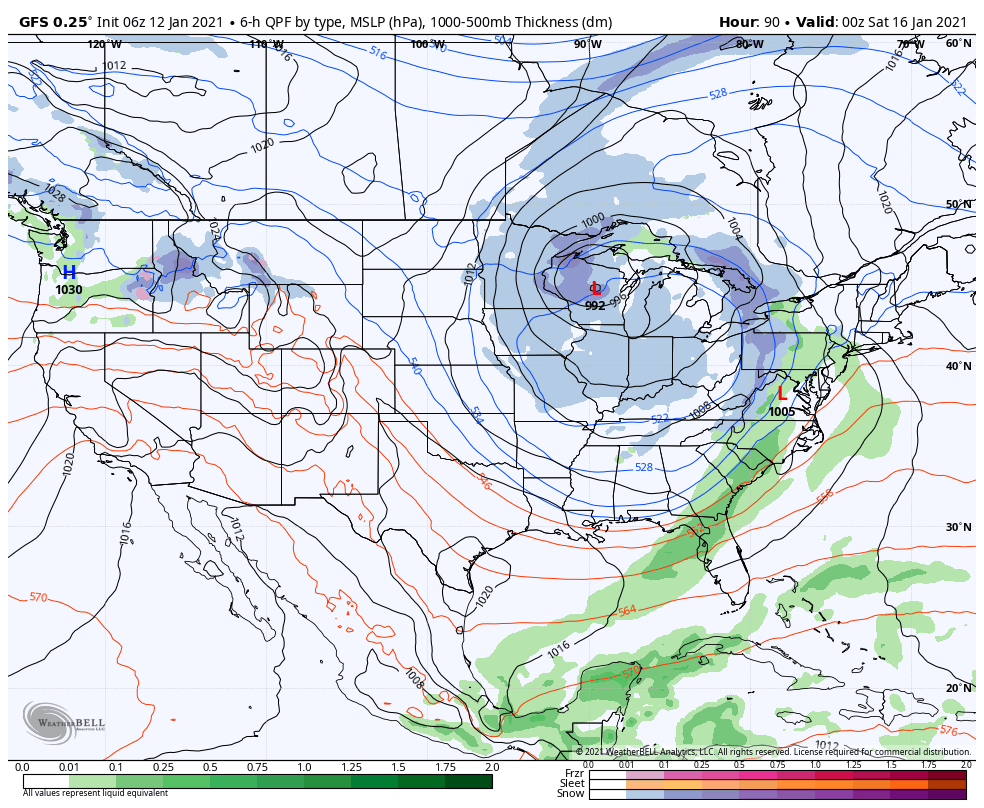
We’re still not looking at heavy snowfall, but the rather persistent nature of light snow this weekend will accumulate to an inch or two for some communities along with a much colder air mass. After Friday evening, temperatures won’t make it above freezing again likely until Tuesday afternoon.
When we look at the bigger picture, this will likely go down as the first “jab” of more exciting weather to wrap up the month of January.
While still not overly cold (doesn’t have to be this time of year for wintry issues to arise), the pattern does look very, very active through the 2nd half of January and to open at least the 1st week of February. While the Greenland Block continues to mature, note the change in the Pacific. We may finally be able to get a negative EPO to develop to align with the negative AO and NAO.
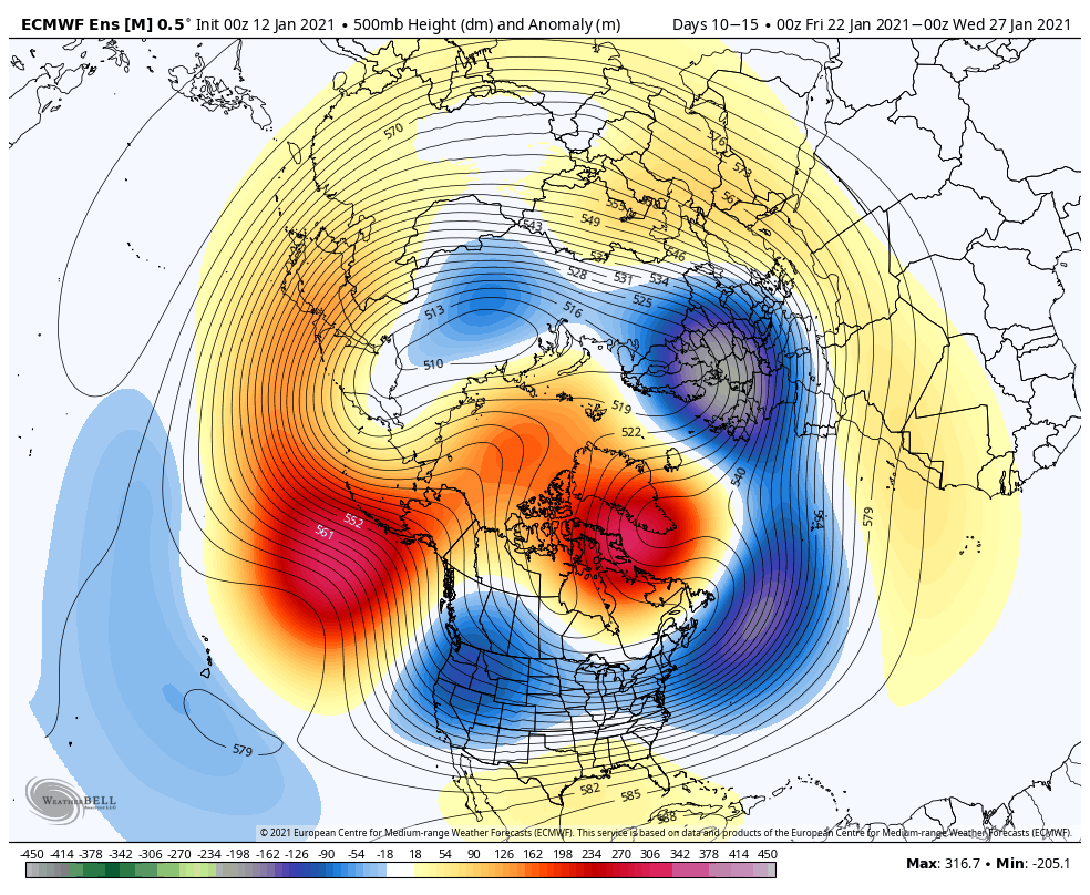
If this does, indeed, transpire we should see a rather expansive snowpack get laid down across the country during the last week to 10 days of January. It would then be this time into early February to look for the possibility of more significant arctic air to spread out and cover more of the Lower 48 (after initially likely being bottled up in western Canada and the northern Rockies).
At the very least, times are becoming more interesting. It’ll be a fun ride through the rest of the month and to open February.
Permanent link to this article: https://indywx.com/1st-wintry-jab-blows-into-town-this-weekend-in-what-should-be-a-stormy-finish-to-january/
Jan 08
Updated: 01.08.21 @ 8:12a Sunshine returns over the weekend. A shot of colder air (and perhaps snow) looms late next week…
You must be logged in to view this content. Click Here to become a member of IndyWX.com for full access. Already a member of IndyWx.com All-Access? Log-in here.
Permanent link to this article: https://indywx.com/video-sunshine-returns-saturday-looking-at-the-week-ahead/
Jan 05
You must be logged in to view this content. Click Here to become a member of IndyWX.com for full access. Already a member of IndyWx.com All-Access? Log-in here.
Permanent link to this article: https://indywx.com/video-pattern-evolution-into-mid-january/
Dec 24
Right off the bat, the theme we want to drive home is that while active, the pattern ahead isn’t overly cold. Cold enough, at times, to create some wintry “fun and games?” Absolutely, but we’re not forecasting a widespread period of sustained cold over the next few weeks.
While the teleconnections favor durable cold from an AO/ NAO perspective…
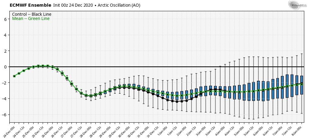

…the EPO isn’t as favorable, and will likely present some warmer times in between the colder shots.

As it is, note how the blocking really matures from Week 1 to Week 2.

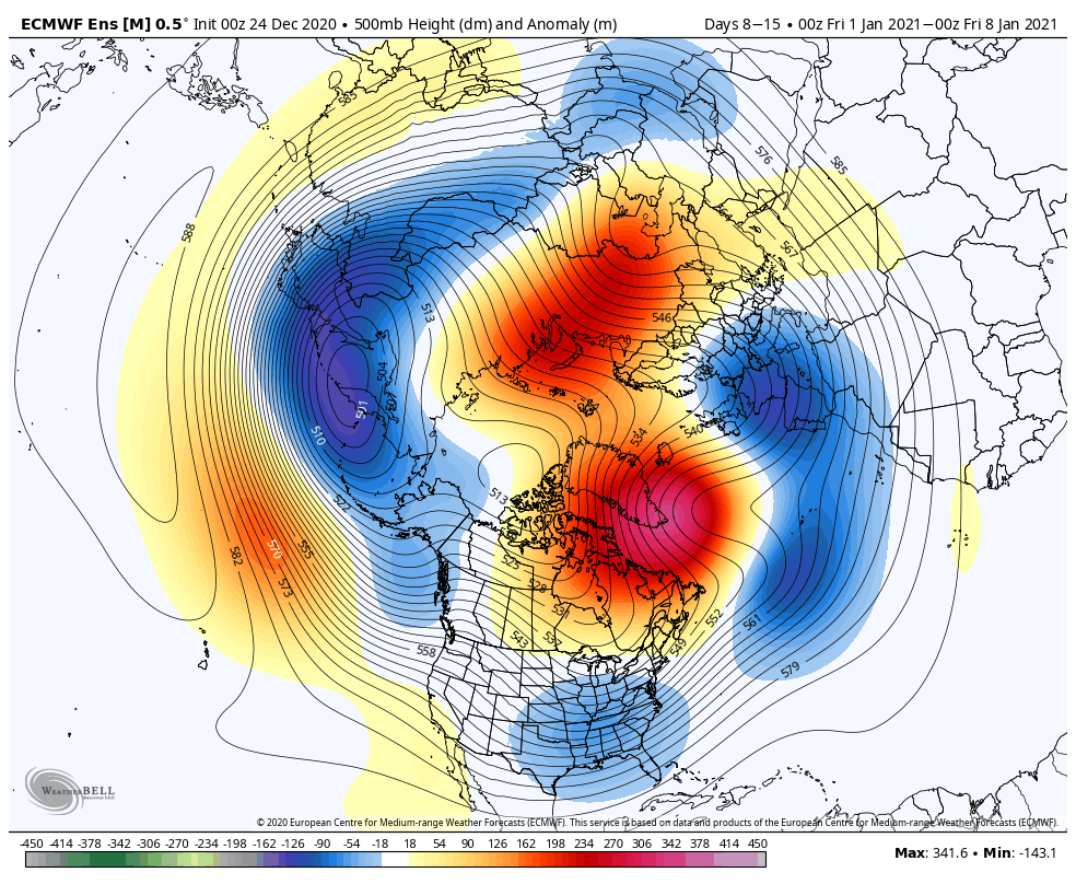
Undoubtedly this will force a stormy period into (at least) the first half of January. At times, initially, Great Lakes cutters are possible, but as we get closer to NYE and into the 1st week of January, itself, I think that’s the window that we really need to focus on for the potential of 1, if not 2, OHV winter storm threats.
The longer range, weekly models are trending in an interesting direction for the 1st full week of January, “marrying” the moisture with the cold, locally.
CFSv2
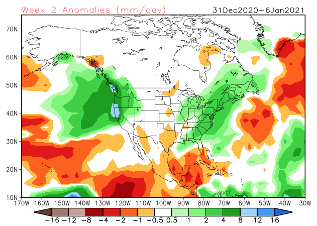
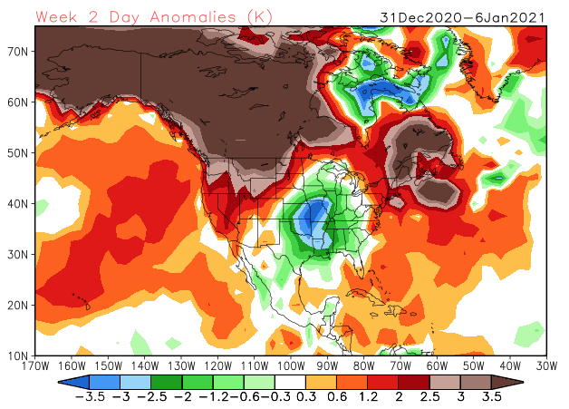
The JMA Weeklies are also intriguing from an upper air perspective (very similar to what the other ensemble data shows for the similar time frame).

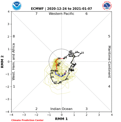
While we’re not ready to unveil our January Outlook just yet (that will come next week), I think we’ll need to start keeping a closer eye on the MJO by the middle and latter part of the month. As things stand now, it appears we may sneak into Phase 2 to open the month (favors cold, locally) before potentially getting into a milder Phase 3 towards the end of the first week.

As things stand now, once the brief arctic intrusion gets out of here this weekend, temperatures will go into a “yo-yo” mode next week as (2) storm systems impact the area between Sunday and Wednesday. The date to keep a closer eye on for potential wintry impacts is more towards Jan. 2-4 time frame as the blocking gets into better position/ matures.
We’ll be back with a video update later today. Until then, Merry Christmas Eve from our family to yours.
Permanent link to this article: https://indywx.com/long-range-update-merry-christmas-eve-from-our-home-to-yours/