You must be logged in to view this content. Click Here to become a member of IndyWX.com for full access. Already a member of IndyWx.com All-Access? Log-in here.
Category: Ensemble Discussion
Permanent link to this article: https://indywx.com/2021/01/05/video-pattern-evolution-into-mid-january/
Jan 04
VIDEO: Suppression Is The Name Of The Game This Week, But Changes Loom Next Week…
You must be logged in to view this content. Click Here to become a member of IndyWX.com for full access. Already a member of IndyWx.com All-Access? Log-in here.
Permanent link to this article: https://indywx.com/2021/01/04/video-suppression-is-the-name-of-the-game-this-week-but-changes-loom-next-week/
Jan 02
VIDEO: Snowy Scene Come Sunday Morning; Blocky Pattern Forces Medium-Longer Range Challenges…
You must be logged in to view this content. Click Here to become a member of IndyWX.com for full access. Already a member of IndyWx.com All-Access? Log-in here.
Permanent link to this article: https://indywx.com/2021/01/02/video-snowy-scene-come-sunday-morning-blocky-pattern-forces-medium-longer-range-challenges/
Dec 31
VIDEO: Freezing Rain Creates Slick Roads Friday Morning; Active Pattern To Open Up 2021…
You must be logged in to view this content. Click Here to become a member of IndyWX.com for full access. Already a member of IndyWx.com All-Access? Log-in here.
Permanent link to this article: https://indywx.com/2020/12/31/video-freezing-rain-creates-slick-roads-friday-morning-active-pattern-to-open-up-2021/
Dec 27
A Word On Our New Year’s Eve Storm…
There will be great wailing and gnashing of teeth in the days ahead over the operational model changes that are sure to come with our New Year’s Eve storm. Knowing what’s to come with the operational guidance, let’s take a step back and look at the bigger picture. Below, I’ve included a couple of images of the 500mb pattern (upper level air pattern) from the GFS ensemble. The first image is dug out from the archives and features our Christmas Eve storm. The second image is the storm in front of us for New Year’s Eve.


There are several differences, but the most notable one to us is the strength and orientation of the blocking high to our northeast. Secondly, the sharp wave break (deep trough) is not part of our NYE storm like it was Christmas Eve. While there are other ingredients in the pot to stir, these are two significant differences that lead us to believe the upcoming NYE storm will be a big-hitter for the Mid West and portions of the western OHV, as opposed to the more progressive event east of here Christmas Eve. The pattern will allow a couple of features to slow down and strengthen (amount to be determined, but perhaps significantly so) to create a more “revved up,” western storm to close out the year.
From this distance, Indianapolis and central Indiana is at least in the game for wintry fun NYE, but there will be much fine tuning ahead.
More later today! Enjoy your Sunday!
Friendly reminder I am traveling this week to see family and loved ones. Posts will come daily, but our regular schedule will be off because of this. Merry Christmas!
Permanent link to this article: https://indywx.com/2020/12/27/a-word-on-our-new-years-eve-storm/
Dec 26
VIDEO: Tricky System Dialed Up To Close Out The Year…
We’re tracking a complex storm system to close out the year. Unlike it’s predecessor, I think central and western portions of the OHV are at an increased risk of wintry…
You must be logged in to view this content. Click Here to become a member of IndyWX.com for full access. Already a member of IndyWx.com All-Access? Log-in here.
Permanent link to this article: https://indywx.com/2020/12/26/video-tricky-system-dialed-up-to-close-out-the-year/
Dec 25
VIDEO: Walking Through The Pattern To Close Out The Year And Open Up 2021…
From our home to yours, we wish you a very merry Christmas and a joyous holiday season!
You must be logged in to view this content. Click Here to become a member of IndyWX.com for full access. Already a member of IndyWx.com All-Access? Log-in here.
Permanent link to this article: https://indywx.com/2020/12/25/video-walking-through-the-pattern-to-close-out-the-year-and-open-up-2021/
Dec 24
Long Range Update: Merry Christmas Eve From Our Home To Yours…
Right off the bat, the theme we want to drive home is that while active, the pattern ahead isn’t overly cold. Cold enough, at times, to create some wintry “fun and games?” Absolutely, but we’re not forecasting a widespread period of sustained cold over the next few weeks.
While the teleconnections favor durable cold from an AO/ NAO perspective…
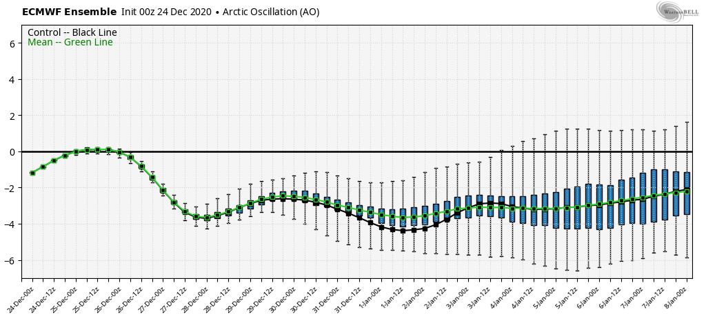

…the EPO isn’t as favorable, and will likely present some warmer times in between the colder shots.

As it is, note how the blocking really matures from Week 1 to Week 2.

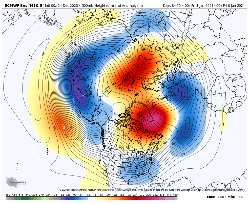
Undoubtedly this will force a stormy period into (at least) the first half of January. At times, initially, Great Lakes cutters are possible, but as we get closer to NYE and into the 1st week of January, itself, I think that’s the window that we really need to focus on for the potential of 1, if not 2, OHV winter storm threats.
The longer range, weekly models are trending in an interesting direction for the 1st full week of January, “marrying” the moisture with the cold, locally.
CFSv2
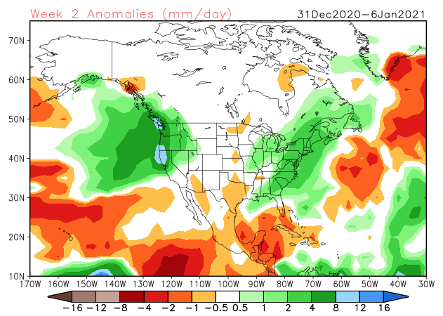
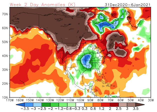
The JMA Weeklies are also intriguing from an upper air perspective (very similar to what the other ensemble data shows for the similar time frame).

While we’re not ready to unveil our January Outlook just yet (that will come next week), I think we’ll need to start keeping a closer eye on the MJO by the middle and latter part of the month. As things stand now, it appears we may sneak into Phase 2 to open the month (favors cold, locally) before potentially getting into a milder Phase 3 towards the end of the first week.
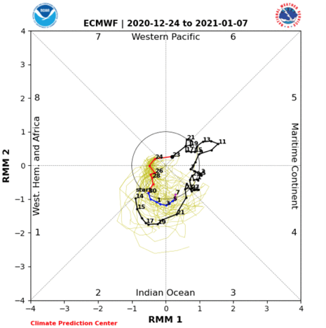

As things stand now, once the brief arctic intrusion gets out of here this weekend, temperatures will go into a “yo-yo” mode next week as (2) storm systems impact the area between Sunday and Wednesday. The date to keep a closer eye on for potential wintry impacts is more towards Jan. 2-4 time frame as the blocking gets into better position/ matures.
We’ll be back with a video update later today. Until then, Merry Christmas Eve from our family to yours.
Permanent link to this article: https://indywx.com/2020/12/24/long-range-update-merry-christmas-eve-from-our-home-to-yours/
Dec 22
VIDEO: Frigid Christmas Gives Way To A Stormy Week Thereafter…
You must be logged in to view this content. Click Here to become a member of IndyWX.com for full access. Already a member of IndyWx.com All-Access? Log-in here.
Permanent link to this article: https://indywx.com/2020/12/22/video-frigid-christmas-gives-way-to-a-stormy-week-thereafter/
Dec 21
Blocking Matures And Forces “Chaos” Underneath…
Before we touch on the post-Christmas period, I wanted to provide a quick update on the pre-Christmas arctic front. In short, we have no changes to our ongoing thoughts concerning this system.
The arctic front is still expected to arrive Wednesday night with showers that end as a “touch” of snow.

MUCH colder and windy conditions can be expected Christmas Eve with upper level energy teaming up with the pressing arctic airmass to help generate backlash snow showers and embedded squalls. These may deposit a dusting to less than 1″ for some, but others likely won’t see any accumulation. Winds will absolutely howl and combine with the falling temperatures to create bitter wind chill values Christmas Eve night into Christmas Day. We still anticipate wind chill values to fall into the 0° to 10° below zero range.
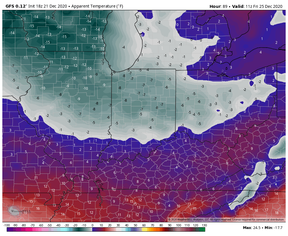
Highs Christmas Day will only top out in the lower 20s.
Then our attention will shift to the period Dec. 27th through Jan. 7th. During this time frame, I’m expecting at least a couple of storm systems to put us on the playing field for more meaningful wintry conditions.
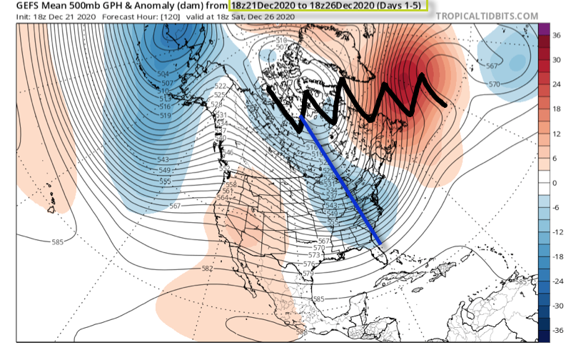
The teleconnections will finally align in a manner more conducive for interior and east coast wintry weather (remember, we’ve been “fighting” that positive EPO as of late). A byproduct of the negative AO and NAO is high latitude blocking. Unlike our Christmas storm (photo 1 below), the blocking matures in significant fashion during the aforementioned period and should force a more favorable storm track (photo 2 below).
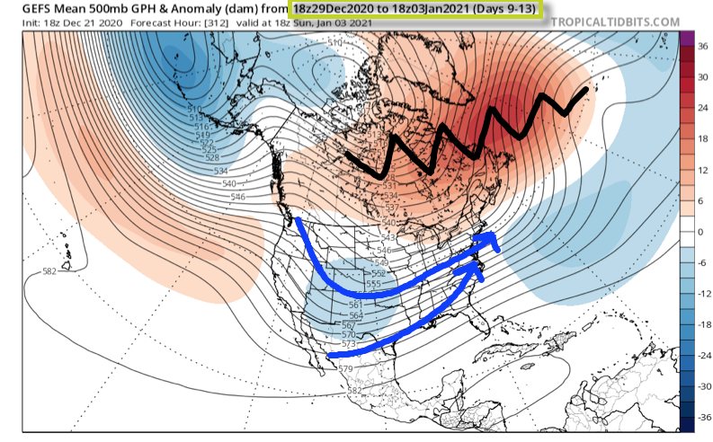
Once to the medium to long range (Days 9-13), the once progressive pattern is no more. Instead, we should see much slower moving storm systems that try and cut into the Ohio Valley only to be forced south. This is the type pattern that can lead to a couple of back-to-back winter weather makers of various significance, including a wintry mix of precipitation across the greater OHV region- especially if only marginally cold air is available. The other item to keep an eye on is the likely trend that develops with the operational data over time. Don’t be surprised to suddenly see guidance trend south with the ‘mean’ storm track during the 12/27 through 1/7 time period as we get closer to real time. This is all a byproduct of the blockiness. Should we get into a situation where we have a couple of winter events lay down accumulating ice and snow then don’t be surprised if the data trends away from the “seasonal” look right now towards one colder as time draws closer.

As it is, this is still a pattern that looks more active/ stormy as opposed to overly cold. With that said, as much as we were against the idea of a big pre-Christmas storm, locally, we remain as bullish as ever on the last few days of December and to open January feeding those hungry for winter weather.
Stay tuned…
Permanent link to this article: https://indywx.com/2020/12/21/blocking-matures-and-forces-chaos-underneath/
