Updated 03.03.21 @ 9:15a
You must be logged in to view this content. Click Here to become a member of IndyWX.com for full access. Already a member of IndyWx.com All-Access? Log-in here.

Mar 03
Updated 03.03.21 @ 9:15a
You must be logged in to view this content. Click Here to become a member of IndyWX.com for full access. Already a member of IndyWx.com All-Access? Log-in here.
Permanent link to this article: https://indywx.com/2021/03/03/video-timing-out-when-more-active-times-return/
Feb 27
Updated 02.27.21 @ 10:15a
You must be logged in to view this content. Click Here to become a member of IndyWX.com for full access. Already a member of IndyWx.com All-Access? Log-in here.
Permanent link to this article: https://indywx.com/2021/02/27/video-analyzing-latest-short-term-heavy-rain-trends-guidance-trends-colder-for-the-eastern-seaboard-days-5-10/
Feb 26
Updated 02.26.21 @ 7:55a
You must be logged in to view this content. Click Here to become a member of IndyWX.com for full access. Already a member of IndyWx.com All-Access? Log-in here.
Permanent link to this article: https://indywx.com/2021/02/26/video-heavy-rain-train-sets-up-along-the-ky-in-border-this-weekend/
Feb 23
Updated 02.23.21 @ 7:51a
You must be logged in to view this content. Click Here to become a member of IndyWX.com for full access. Already a member of IndyWx.com All-Access? Log-in here.
Permanent link to this article: https://indywx.com/2021/02/23/video-the-spring-fling-is-on/
Feb 20
Updated 02.20.21 @ 8:29a
Before we dive into the challenges late next week, the potential is still very much alive and kicking for a period of slick conditions to develop Sunday evening/ night. While we’ll likely be in the middle 30s during the majority of the time this light precipitation is falling, the concern remains, given the duration and magnitude of the cold air (ground is now reported frozen “8 to 12”), that any liquid precipitation that falls will freeze on untreated area roadways and sidewalks. If you have travel plans Sunday night, plan to give yourself plenty of extra time.
Light rain should arrive between 8p and 10p (west to east across the state) Sunday before ending as a bit of light snow (little to no accumulation expected as of now). Total precipitation should be 0.20″ or less for most with this event.

As we look ahead, the next item of possible trouble awaits for mid and late week. A cold front will push south of the area Wednesday night into Thursday morning. While this may generate a brief period of light rain transitioning to light snow, it’s what follows that’s of more interest.
Operational guidance (both the European and GFS) suggest this late week system will present a winter storm for our friends in the TN Valley, but we advise to tread with caution for now.
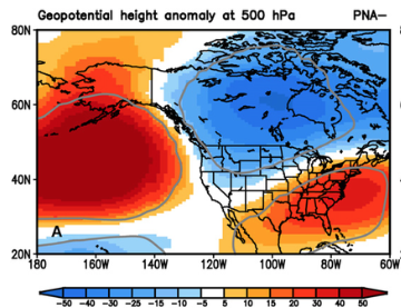
The reason? A strongly negative PNA.
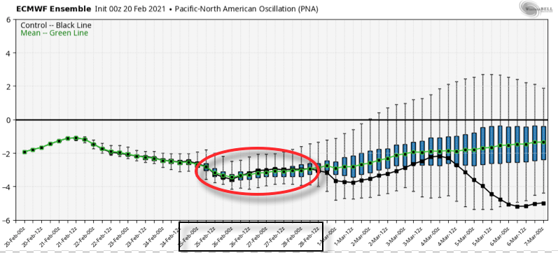
You know the drill by now. This should lead to a more stubborn southeastern ridge and subsequent further north storm track.
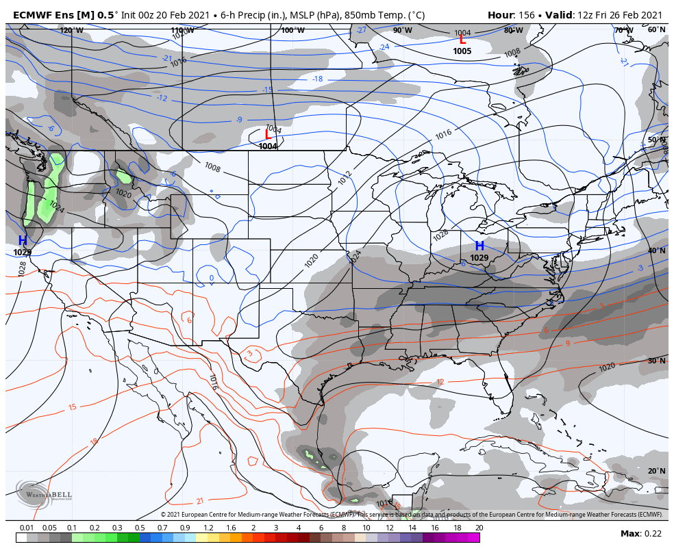
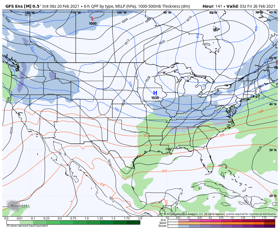
Over time, I’d suspect we’ll see just that- the models trending further north with this particular storm system.
As it is, ensemble guidance is already significantly further north than their respective operational counterparts. At the very least, another interesting case study is in front of us…
Stay tuned!
Permanent link to this article: https://indywx.com/2021/02/20/weve-seen-this-before/
Feb 12
Updated 02.12.21 @ 5:50p
You must be logged in to view this content. Click Here to become a member of IndyWX.com for full access. Already a member of IndyWx.com All-Access? Log-in here.
Permanent link to this article: https://indywx.com/2021/02/12/video-use-the-weekend-to-prepare/
Feb 11
Updated 02.11.21 @ 10:48p I apologize for the abrupt stop in tonight’s video. After rambling on for close to 20 min., YouTube informed me that I had to trim under…
You must be logged in to view this content. Click Here to become a member of IndyWX.com for full access. Already a member of IndyWx.com All-Access? Log-in here.
Permanent link to this article: https://indywx.com/2021/02/11/video-long-range-update-and-fresh-thoughts-on-next-week/
Feb 10
Updated 02.10.21 @ 6:23p
Before we look ahead, snow continues to fall across most of central Indiana. So far, immediate downtown Indy has avoided significant snow, but other areas are approaching 1″ to 2″ already as of this post. We continue to believe another band of snow will organize during the overnight into the predawn hours across central Indiana (especially along and north of the I-70 corridor). Given how cold it’s been as of late, even the lightest snow is creating havoc on area roadways. As winds become gusty, blowing and drifting issues will remain into the day Thursday.
As we look ahead, this pattern remains nothing short of remarkable. Feb. 5th (last Friday at 6p) was the last time Indianapolis was above the freezing mark. As we look ahead, we’re likely talking about another 12 days below freezing (if not longer). The “moderation” that some models are hinting at after that time frame isn’t something I’d label as high confidence at this point. That’s rare territory for central Indiana- even during some of the infamous cold winters of the “good ole days.” There’s also already been a fair share of snow events in this pattern. Sure the big one hasn’t hit (yet), but many across the state are getting used to clearing snow off the sidewalk and driveway on a daily basis. Not counting today’s snow, Indianapolis, officially, sits at 2.3″ month-to-date. Areas downstate received as much as half a foot (or more) earlier this week. As we look ahead, there’s a lot more white gold where that came from. (Keep in mind, the “average” snow total during the month of February in Indianapolis is 6.5″).
A fresh intrusion of arctic air will arrive just in time for the weekend. We’re looking at a mostly dry stretch of weather through the weekend, with the exception of some light snow prospects Saturday. Again, given how cold it’s been, even these light snow events will likely create travel trouble.
The coldest morning appears to be Sunday with lows falling to between 3° and 6° below zero. Wind chill values will approach 20° below zero, or worse, in spots.
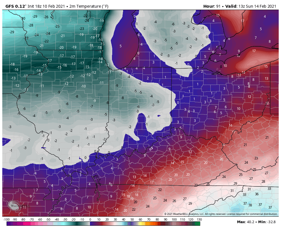

By this time, all eyes will be on the developing storm system in the northwest Gulf of Mexico. There’s already been a great deal of chatter about this storm and that will only continue to ramp up as we move forward. Given the overall pattern and model consensus at this juncture, there’s plenty reason to believe the Ohio Valley, including central Indiana, is in store for a significant winter storm early next week.
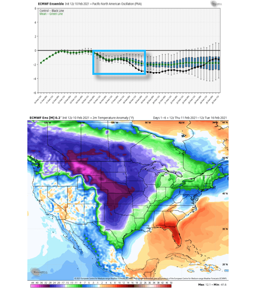
With that said, nothing is a lock in this business. While the negative PNA (image 1 below) argues for the southeast ridge to “flex” it’s muscle and lead to a more inland track, the fact arctic air will be pressing southeast (image 2 below) does at least raise an eyebrow for potential shifts southeast in time over the next couple of days. It’s another fascinating meteorological battle we’ll have the pleasure to watch unfold in real time.
As it sits right now, we favor a storm track that will be far enough west to put central Indiana in play for potentially significant wintry precipitation (far too early to throw numbers out). The early call is for surface low to move out of the northwest Gulf and track west of the mountains before a secondary low take over along the Mid-Atlantic and moves northeast off the New England coast.
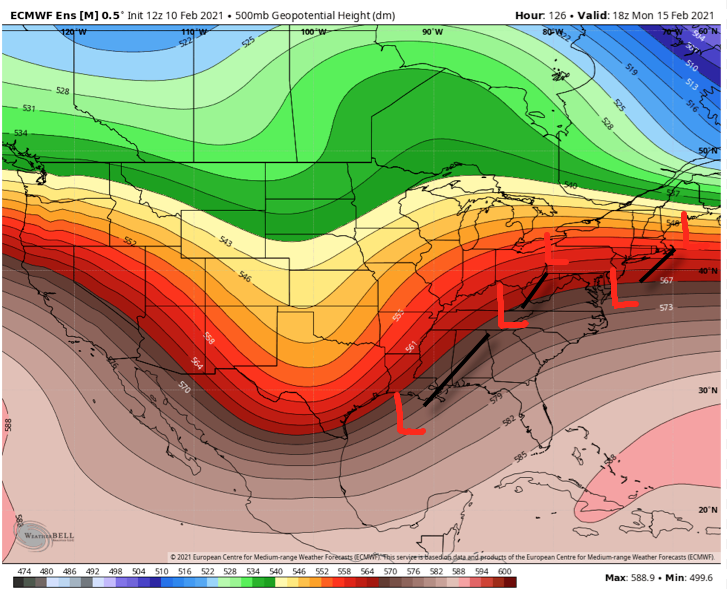
If this wasn’t enough, another storm system likely follows later next week that could also produce additional wintry “goods.”
Will every storm produce in your backyard? Negative. That said, when we get to March 1st, central Indiana winter weather fans are likely to look back on February 2021 as a truly special ride.
I suppose time will tell…
Permanent link to this article: https://indywx.com/2021/02/10/reasons-for-and-against-the-big-one-next-week/
Feb 10
Updated 02.10.21 @ 8:30a
You must be logged in to view this content. Click Here to become a member of IndyWX.com for full access. Already a member of IndyWx.com All-Access? Log-in here.
Permanent link to this article: https://indywx.com/2021/02/10/video-the-beat-goes-on-looking-at-the-pattern-into-late-month/
Feb 08
Updated: 02.08.21 @ 5:35p
You must be logged in to view this content. Click Here to become a member of IndyWX.com for full access. Already a member of IndyWx.com All-Access? Log-in here.
Permanent link to this article: https://indywx.com/2021/02/08/video-cold-snowy-pattern-locking-in-for-the-foreseeable-future/