Updated 11.30.22 @ 7:50a
You must be logged in to view this content. Click Here to become a member of IndyWX.com for full access. Already a member of IndyWx.com All-Access? Log-in here.

Nov 30
Updated 11.30.22 @ 7:50a
You must be logged in to view this content. Click Here to become a member of IndyWX.com for full access. Already a member of IndyWx.com All-Access? Log-in here.
Permanent link to this article: https://indywx.com/2022/11/30/video-fast-moving-pattern-into-mid-next-week-december-evolution/
Nov 27
Updated 11.27.22 @ 6:20p
You must be logged in to view this content. Click Here to become a member of IndyWX.com for full access. Already a member of IndyWx.com All-Access? Log-in here.
Permanent link to this article: https://indywx.com/2022/11/27/video-updated-thoughts-on-the-december-pattern/
Nov 26
Updated 11.26.22 @ 6a
November opened well above normal on the temperature front. The first (11) days of the month featured above to well above average conditions, including multiple days with highs into the 70s. A dramatic change followed, thanks to a strong frontal passage on the 11th. The following (10) days were made up of well below normal temperatures, including a few days that didn’t feature highs getting out of the lower 30s. We’re now back to an overall milder than normal time to close out the month (IND officially is running right at “average” as of this post despite the wild swings).

Wild temperature swings are common in the fall and at times those can continue into December. With that said, despite a relatively mild first few days of the month, we continue to believe December ’22 will be made up of more sustained cold than the majority of the Decembers we’ve come to know over the past decade.
Our research from summer began to highlight reasoning for this idea and now that we’re front and center, we note the important pattern “drivers” aligning in such a manner that will likely lead to cold overwhelming our pattern as we move deeper into the month. The negative EPO, combined with the anticipated MJO movement through the traditionally cold phases ups the ante for a wintry stretch as the holidays kick into high gear. Add in a negative PNA (at least initially) and that should provide enough resistance from storms simply bypassing us to the south. Simply put, we believe the chances are high for 1 or 2 accumulating wintry events in the Dec. 5-15 time period. Thereafter, the thought here is that the cold grows stronger and likely deeper into the south.
It’s hard to argue with the overall look of the GEFS Extended below. If anything, I would anticipate the model (and others) correcting colder for mid and late December, especially with the idea of an expanding snow pack taking shape.


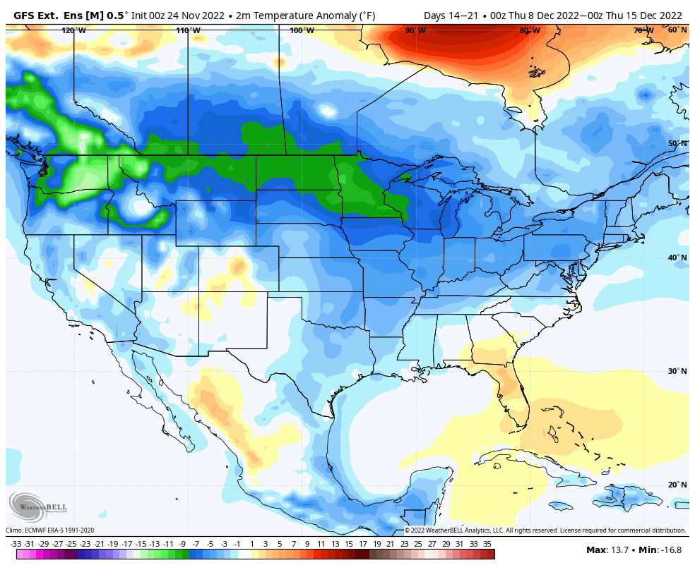
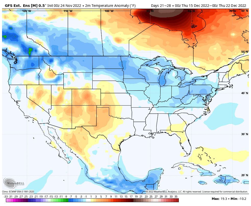

Indianapolis averages 6.4″ of snow each December. We feel that the pattern supports above average snow this December to combine with the anticipated persistent below normal temperatures.
Not sure we can get to the level of December ’00 cold (a chief analog year), but it’s fun to see shades of the past providing hints to the future…

At the very least, fans of wintry weather around the holidays can’t ask for a better pattern setup than the stage that’s being set this year.
Permanent link to this article: https://indywx.com/2022/11/26/after-novembers-cold-jab-is-the-stage-set-for-winter-to-set-in/
Nov 25
Updated 11.25.22 @ 8:31a
You must be logged in to view this content. Click Here to become a member of IndyWX.com for full access. Already a member of IndyWx.com All-Access? Log-in here.
Permanent link to this article: https://indywx.com/2022/11/25/video-timing-out-when-rain-returns-and-looking-ahead-to-colder-times/
Nov 24
Updated 11.24.22 @ 9a
You must be logged in to view this content. Click Here to become a member of IndyWX.com for full access. Already a member of IndyWx.com All-Access? Log-in here.
Permanent link to this article: https://indywx.com/2022/11/24/happy-thanksgiving-a-lot-to-cover-over-the-upcoming-couple-weeks/
Nov 23
Updated 11.23.22 @ 7:55a
You must be logged in to view this content. Click Here to become a member of IndyWX.com for full access. Already a member of IndyWx.com All-Access? Log-in here.
Permanent link to this article: https://indywx.com/2022/11/23/video-timing-out-thanksgiving-weekend-rain-more-on-the-cold-snowy-december-on-deck/
Nov 22
Updated 11.22.22 @ 8:04a
You must be logged in to view this content. Click Here to become a member of IndyWX.com for full access. Already a member of IndyWx.com All-Access? Log-in here.
Permanent link to this article: https://indywx.com/2022/11/22/video-great-travel-weather-leading-up-to-thanksgiving-timing-out-periods-of-rain-over-the-holiday-weekend/
Nov 21
Updated 11.21.22 @ 6:37p
It only took a week to 10 days, but model guidance is FINALLY starting to align on our Thanksgiving storm, and it’s for a more drawn out period of wet, unsettled weather through the Thanksgiving weekend. We still believe clouds will increase through the day on Thanksgiving with light rain moving into central Indiana Thursday evening/ night. The initial surge of moisture should move out of the area early on Black Friday. Early thoughts are for this lead wave to deposit between 0.10″ and 0.25″ for most.
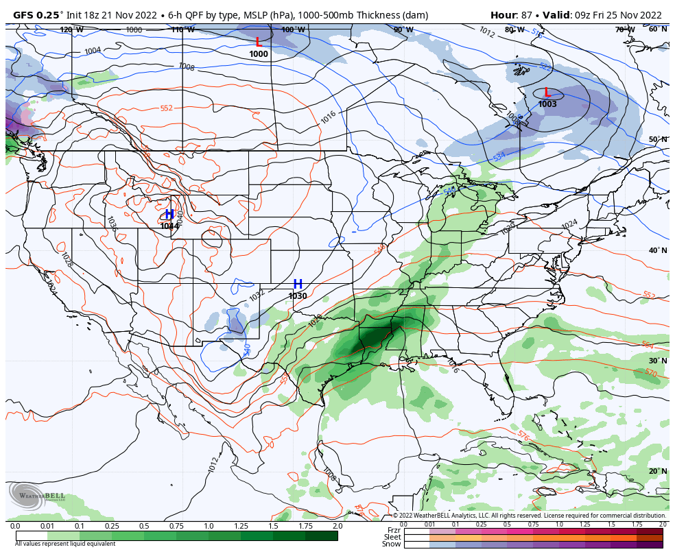

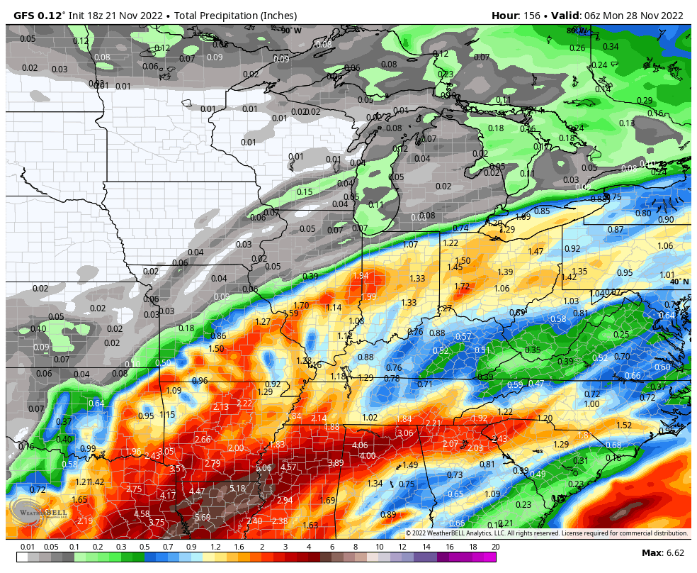
Most, if not all, of our Black Friday and through the daytime Saturday currently looks on the dry side. While we’ll still have considerable cloudiness, the next round of moisture (this of a much heavier variety) is dialed up Saturday evening into Sunday as a surface low moves from the Ark-la-tex region, northeast into the central and eastern Ohio Valley. A 1″ to 2″ soaker appears in order from a standpoint of total rain with this system.
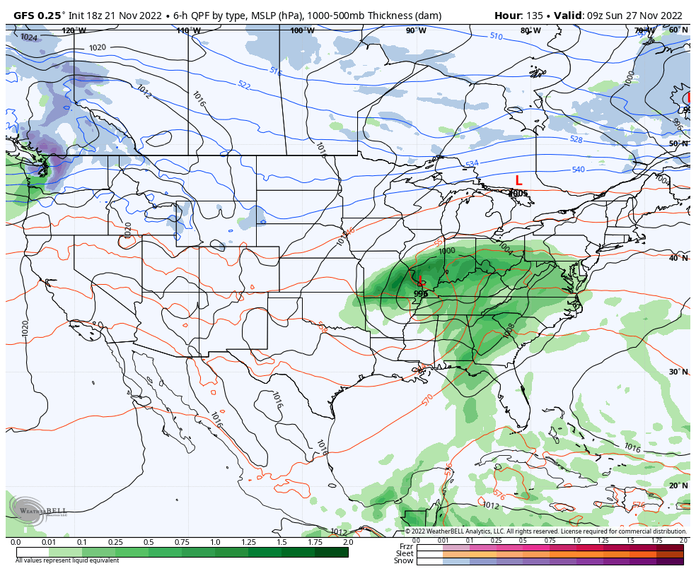
Once the system departs to the northeast, unlike the past couple of events, milder air will take hold to close November and open December. In fact, multiple days with highs into the 60s are a good bet 12/1 through 12/5.
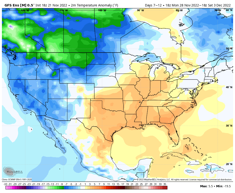
In the face of the warm open to the month, there’s no flinching in our long standing idea of an overall colder/ snowier than normal December, locally. We note the EPO is forecast negative down the road and combine this with what continues to look like a favorable (at least if you’re a winter fan) MJO, the thought here remains squarely on the return of colder, more wintry times after the first few days of the month…

Permanent link to this article: https://indywx.com/2022/11/21/thanksgiving-storm-system-and-december-pattern-rambles/
Nov 21
Updated 11.21.22 @ 7:40a
You must be logged in to view this content. Click Here to become a member of IndyWX.com for full access. Already a member of IndyWx.com All-Access? Log-in here.
Permanent link to this article: https://indywx.com/2022/11/21/video-continuing-to-keep-close-eyes-on-our-thanksgiving-storm-system/
Nov 20
Updated 11.20.22 @ 10a
You must be logged in to view this content. Click Here to become a member of IndyWX.com for full access. Already a member of IndyWx.com All-Access? Log-in here.
Permanent link to this article: https://indywx.com/2022/11/20/video-compared-to-the-past-week-a-milder-pattern-emerges-as-we-get-ready-to-close-november/