You must be logged in to view this content. Click Here to become a member of IndyWX.com for full access. Already a member of IndyWx.com All-Access? Log-in here.
Category: Ensemble Discussion
Permanent link to this article: https://indywx.com/2019/02/23/saturday-afternoon-video-update-damaging-winds-develop-late-tonight-more-conversation-around-the-march-pattern/
Feb 22
VIDEO: Scattered Storms Saturday Give Way To Damaging Winds And Snow Showers To Close The Weekend…
A busy weekend awaits as stormy Saturday evening give way to a 12-18 hour period of potentially damaging wind gusts. Rain will end as wind-whipped snow to close the weekend…
You must be logged in to view this content. Click Here to become a member of IndyWX.com for full access. Already a member of IndyWx.com All-Access? Log-in here.
Permanent link to this article: https://indywx.com/2019/02/22/video-scattered-storms-saturday-give-way-to-damaging-winds-and-snow-showers-to-close-the-weekend/
Feb 20
It Was A Case Of Delayed, But Not Denied…
While arriving later than originally expected (recall we originally thought the cold, wintry pattern would start on the 18th), it sure appears as if this was a case of “delayed, but not denied.”
The latest GFS and European ensembles are keying in on a significant pattern change as we put a wrap on February and open March. (Looks like we were about a week early in jumping on the cold bandwagon).

First and foremost, there’s excellent overall agreement amongst data (increases confidence significantly during the medium to long range period).
Days 1-5: Southeast ridge continues to dominate during the short-term period and there’s no high-latitude blocking to speak of. This suggests storms will continue to “cut” northwest of the region and place central Indiana in the “warm” sector, with transient, backlash cold/ snow potential.
Days 6-10: Significant changes begin to take place as heights (ridging) builds across AK. This is important as it can help “dislodge” late season cold air (and send it southeast). The SE ridge is also in the process of getting squashed during this period. We’ll likely transition away from the moisture-laden storm systems and replace with faster, overall weaker, systems that will be more capable of producing wintry precipitation.
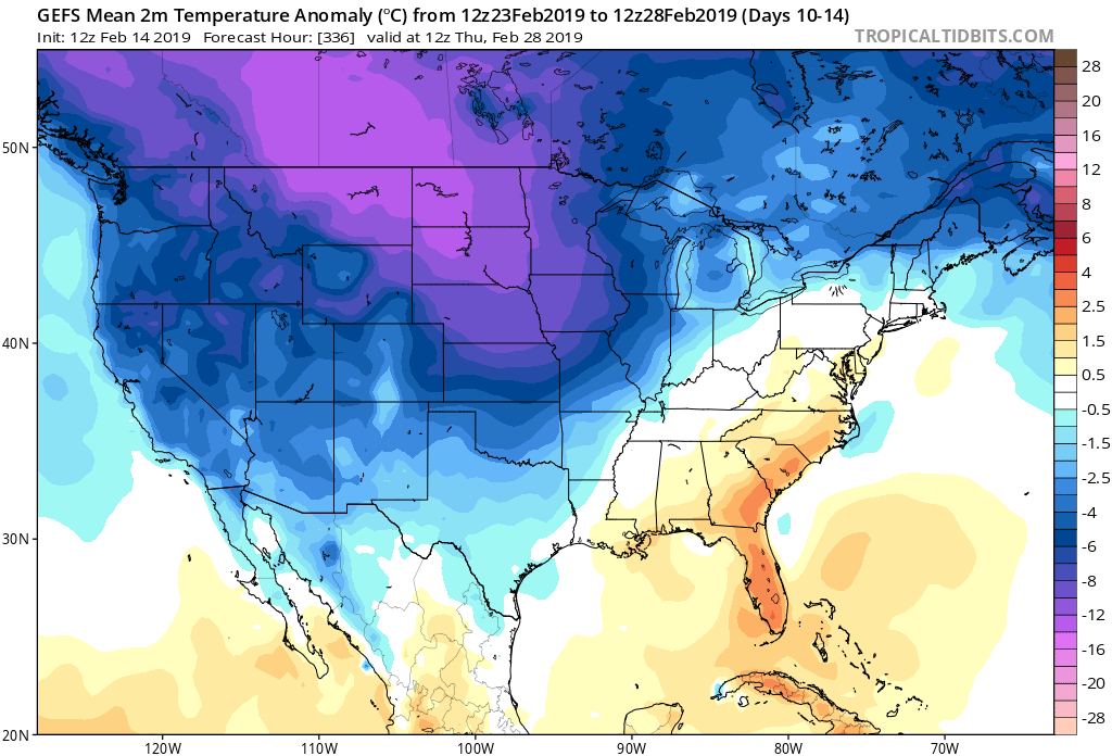
Days 12-16: A total transformation of the pattern has taken shape since the Day 1-5 period. The new ‘mean’ trough position takes up shop across the East with the AK ridge continuing to dislocate late season arctic air southeast. The GEFS also shows a reflection of a southwest ridge which can be helpful in the overall storm track that could potentially deliver more “meaningful” wintry systems across the OH and TN Valleys as we get into the first couple weeks of meteorological spring.
Side notes: We’ve reviewed the crashing SOI index and this increases our confidence in a much colder pattern developing (typically takes place around 10-12 days after the crash begins). We’ve noted the deeply negative values against the base state which would suggest the cold pattern should continue for some time. We still believe the pattern remains colder than average, overall, through the 1st half of March.
The latest deeply negative EPO adds fuel to the fire in the idea of a cold open to March.
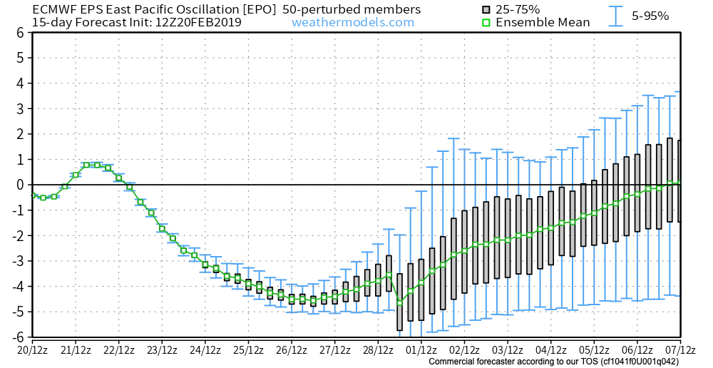
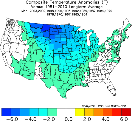
Given this, there should be no surprise to see the cold anomalies showing up on the latest medium-long range ensemble guidance:
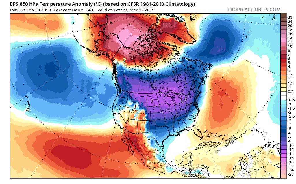
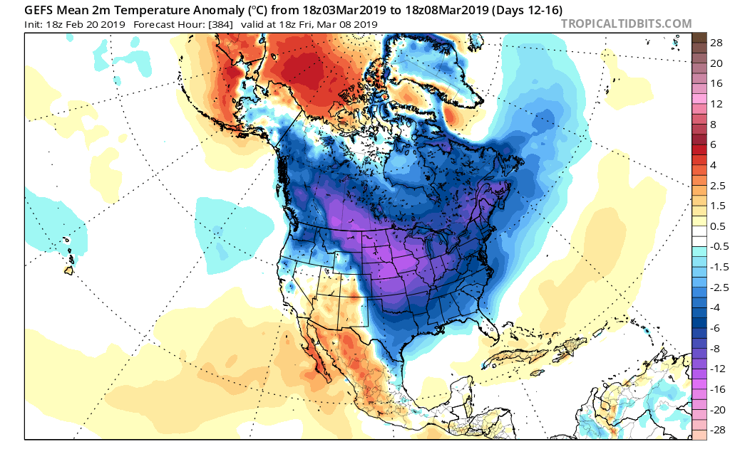
It sure appears March will come in like a lion; will it go out like a lamb?
Permanent link to this article: https://indywx.com/2019/02/20/it-was-a-case-of-delayed-but-not-denied/
Feb 19
Evening Video Update: Snow, Storms, And A Major Pattern Shift On The Horizon…
You must be logged in to view this content. Click Here to become a member of IndyWX.com for full access. Already a member of IndyWx.com All-Access? Log-in here.
Permanent link to this article: https://indywx.com/2019/02/19/evening-video-update-snow-storms-and-a-major-pattern-shift-on-the-horizon/
Feb 19
Tuesday Morning Video Update: From Snow To Storms And Looking Ahead To March…
A “thump” of sleet and snow will give way to strong storm potential Saturday. Looking ahead, winter appears to make a comeback during the 1st half of March…
You must be logged in to view this content. Click Here to become a member of IndyWX.com for full access. Already a member of IndyWx.com All-Access? Log-in here.
Permanent link to this article: https://indywx.com/2019/02/19/tuesday-morning-video-update-from-snow-to-storms-and-looking-ahead-to-march/
Feb 18
Monday Morning Video Update: Accumulating Snow Tuesday Night To Weekend Storm Potential…
Light snow showers will continue today, but attention is on the potential of a “thump” of snow tomorrow night into early Wednesday morning. Thereafter, another big storm is set to…
You must be logged in to view this content. Click Here to become a member of IndyWX.com for full access. Already a member of IndyWx.com All-Access? Log-in here.
Permanent link to this article: https://indywx.com/2019/02/18/monday-morning-video-update-accumulating-snow-tuesday-night-to-weekend-storm-potential/
Feb 17
Sunday Morning Video Update…
A wintry mix this morning sets the stage for another active week of weather across central Indiana. We also look forward to late Feb and early March…
You must be logged in to view this content. Click Here to become a member of IndyWX.com for full access. Already a member of IndyWx.com All-Access? Log-in here.
Permanent link to this article: https://indywx.com/2019/02/17/sunday-morning-video-update-3/
Feb 14
Reviewing The Latest European Weeklies And Updated Long Range Thoughts…
We’re growing closer and closer towards the period we’ve been thinking would present one last round of cold, wintry weather (relative to normal) for the ’18-’19 season.
While the stormy idea will likely end up being correct, the significant cold that we thought would “spread out” (as opposed to being confined to the NW and northern Plains) is in jeopardy.
The overall upper air pattern over the upcoming few weeks will likely continue to be dominated by a mean trough position across the central and west, along with the persistent southeast ridge.
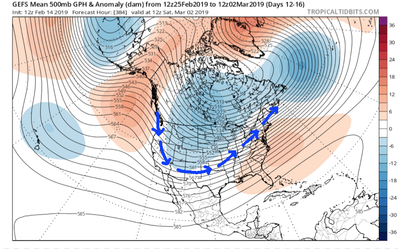
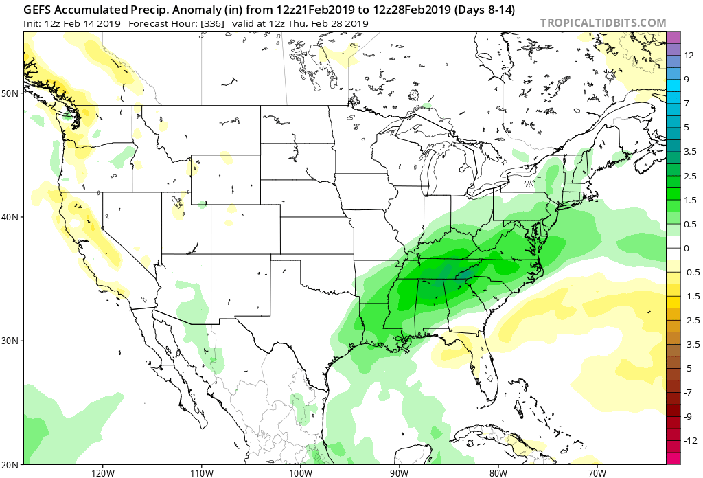
This will continue to result in above normal precipitation into the first week to 10 days of March, with a very active storm track.
From a temperature perspective, the baseline of our ideas being centered on the MJO appears to be the error in our forecast. It’s not that the MJO isn’t heading into Phase 8 (it’s officially there now, as noted below), but it appears other teleconnections are “trumping” this cold ingredient.
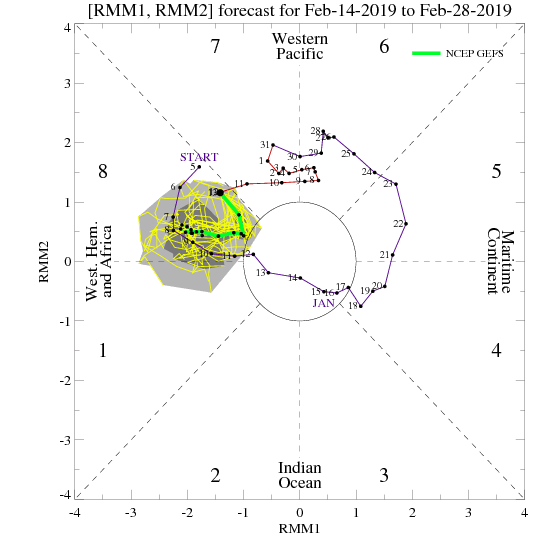

The combination of the positive Arctic Oscillation (AO) and negative Pacific North America pattern (PNA) are the drivers and are showing no signs of wanting to let go of the wheel.
The AO is forecast to remain strongly positive into early March.

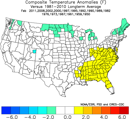
The PNA is forecast to remain negative into early March.
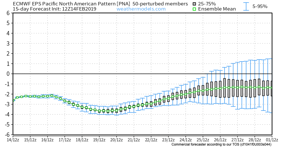

Note how both of the above support that southeast ridge and associated relative warmth.
At one time, it appeared as if the North Atlantic Oscillation (NAO) would dip negative, however, that’s no longer the case.
While the active idea will come to fruition, the cold (at least to the magnitude we thought) will have a difficult time. That isn’t to say that enough cold air won’t get involved with a couple of these storms to result in wintry precipitation of significance, but rather that sustained cold will be tough to come by. Snowfall (of the heavy, wet variety) very well still could end up above normal with these moisture-laden systems over the next few weeks.
European Weekly Update
The new European Weeklies are in and follow the idea above nicely. They forecast a very stormy pattern to persist over the next few weeks with a battle ground between cold to our northwest and warmth to our southeast. We’ll have to be watchful for a couple of storm systems capable of delivering heavy amounts of precipitation. Given the teleconnection states over the next 6 weeks, it continues to look like any sort of significant wintry weather will need to take place before mid-March. Thereafter, warmer than normal times are expected, including true spring-like weather emerging. I know most can’t wait…
Permanent link to this article: https://indywx.com/2019/02/14/reviewing-the-latest-european-weeklies-and-updated-long-range-thoughts/
Feb 12
We Have The Storms; Time To Add The Cold…
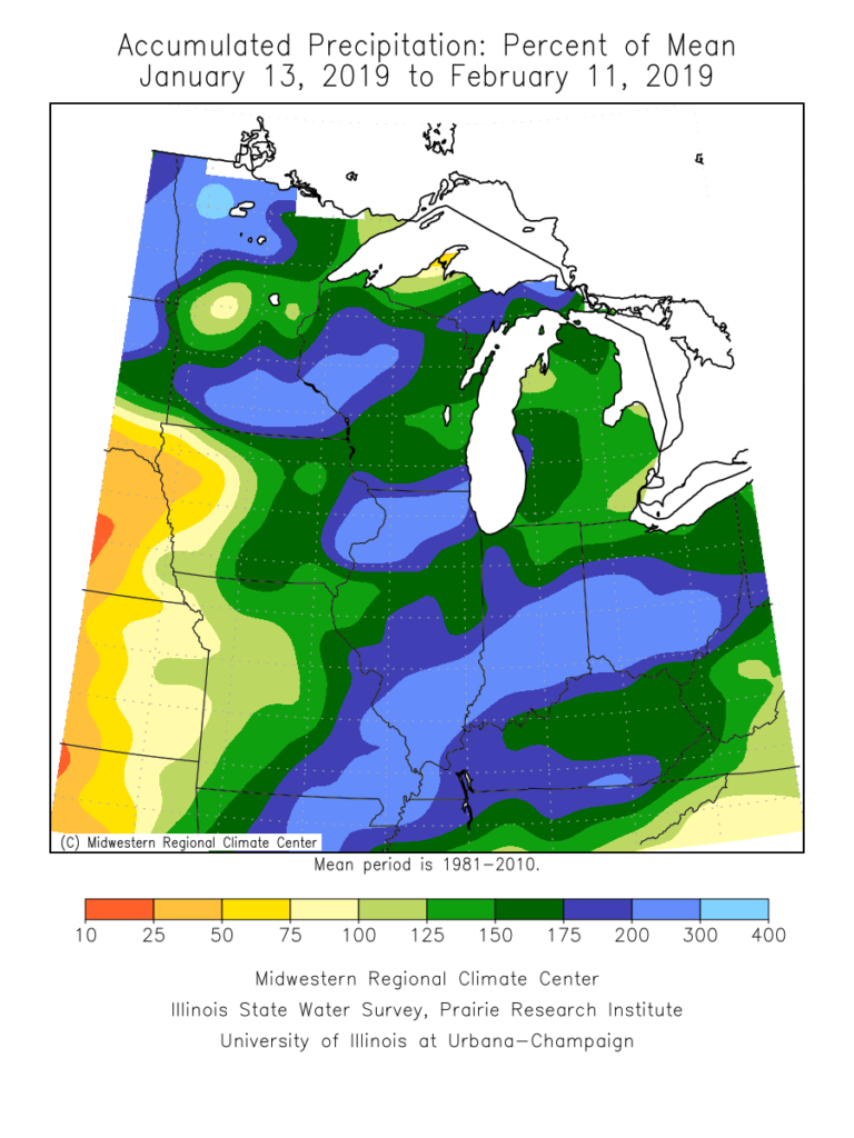
Over the past month, a widespread portion of the Ohio Valley, including central Indiana, is running close to 200% of average in the precipitation department. There’s no wonder flooding issues have resulted in spots- especially across the lower OHV region.
As we look ahead, the active storm track will persist, but there will be one key missing ingredient from the better part of the past couple of weeks and that’s more in the way of sustained cold. After reviewing some of the latest data, there’s no reason to change our ongoing idea of the transitional period (in the midst of that now) giving way towards one that will feature more in the way of “lock and load” cold in that 2.18 through 3.10 time period. We expect this period will run well below average in the temperature department and above average in the snowfall category. Snow removal clients, we recommend gearing up for a busy time of things over the upcoming few weeks.
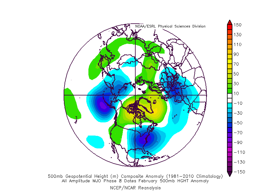
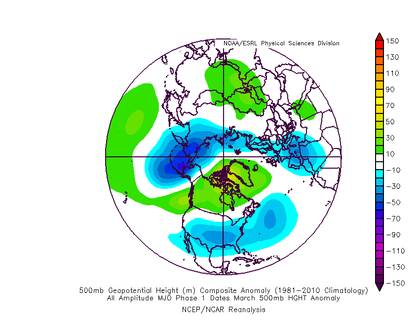
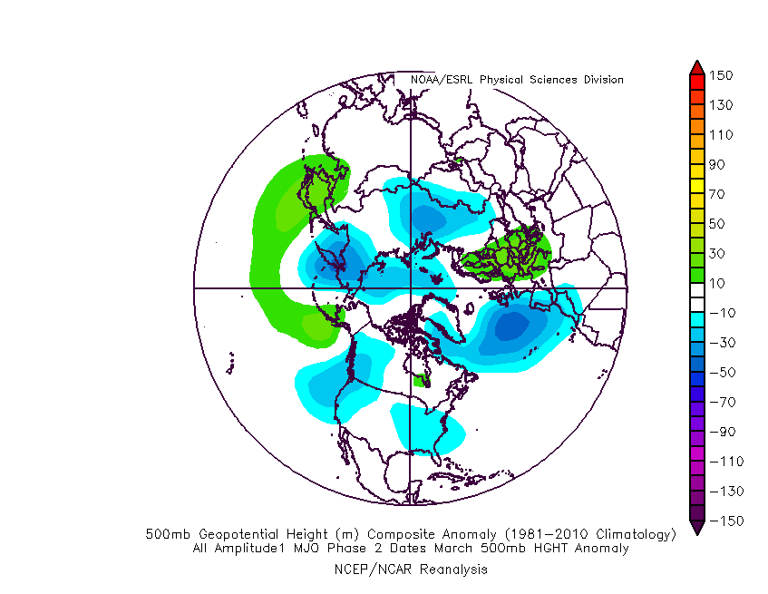
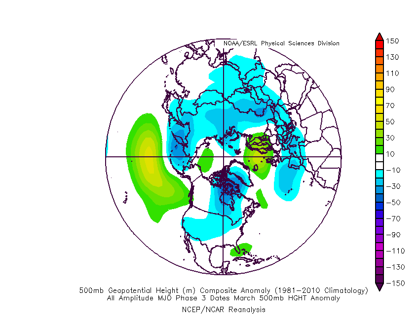
The basis of this idea initially focused squarely on the MJO and the fact that modeling was keying in on things swinging into the favorable cold phases of 8, 1, and 2.
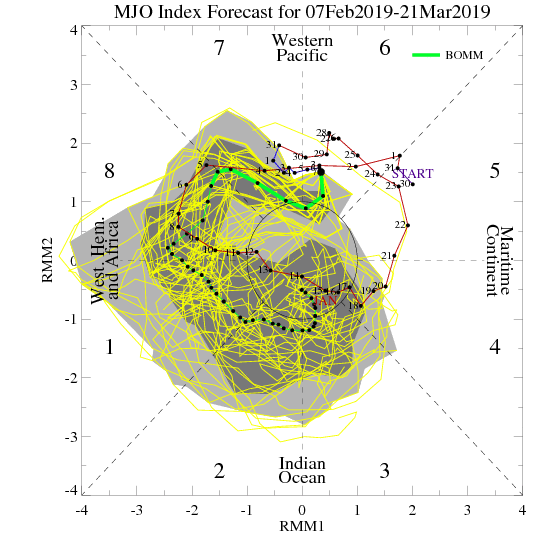
Taken at face value, this would be the corresponding upper air look in those respective phases:
Phase 8 (coldest)
Phase 1
Phase 2
Phase 3 (cold begins to “back into the west and there’s at least a hint of the SE ridge returning)
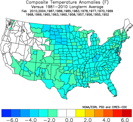
As most longtime followers know, we put more stock into the NAO state during the latter winter and spring months, as this teleconnection can “trump” others during this time frame. We notice the NAO is forecast to trend negative as we progress through the back half of February.

A negative NAO will result in widespread cold this time of year:
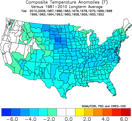
After remaining strongly positive for the past couple of weeks, the AO is forecast to plunge negative as we progress through the remainder of February. Again, this increases confidence on a return of more sustained and significant cold potential.

It should also be pointed out that the active pattern should continue, especially considering the southeast ridge should put up some resistance over the upcoming couple of weeks. The latest ensemble products would agree in the mean upper air pattern:

With colder air overwhelming the pattern, more of these storms will be capable of producing impactful wintry precipitation over the upcoming few weeks. After storms grab the headline, attention will shift to the possibility of another significant arctic blast before the end of the month.
In the more immediate term, we continue to keep close tabs on the following dates for the potential of snow and/ or ice:
I. Friday night, 2/15 and Saturday, 2/16- southern half of Indiana
II. Sunday, 2/17
III. Tuesday night, 2/19 and Wednesday, 2/20
Permanent link to this article: https://indywx.com/2019/02/12/we-have-the-storms-time-to-add-the-cold/
Feb 12
All-Access Video Update: Timing Out The Wintry Threats In The Upcoming Week (And Beyond)…
You must be logged in to view this content. Click Here to become a member of IndyWX.com for full access. Already a member of IndyWx.com All-Access? Log-in here.
Permanent link to this article: https://indywx.com/2019/02/12/all-access-video-update-timing-out-the-wintry-threats-in-the-upcoming-week-and-beyond/
