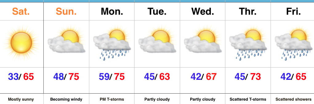
Category: Easter

Can’t Beat This Weekend Weather…

Highlights:

  • Sun-filled weekend
  • Sunday turns windy
  • Storms arrive Monday evening

Sunscreen Required This Weekend…It’s not very often around these parts where we can dial-up two beautiful weekends in back-to-back fashion, but that’s exactly what we’ll do.  High pressure will supply a gorgeous Saturday and Sunday, complete with plentiful sunshine.  We’ll add 10° Sunday, but also throw in 30-40 MPH wind gusts, especially by afternoon.  Get outside and enjoy this weather!

A weak frontal boundary will slip into the state Monday afternoon and will likely kick-up some thunderstorms as it pushes southeast Monday afternoon and evening.  A strong thunderstorm, or two, can’t be ruled out.  We’re back to dry weather midweek before unsettled weather returns to close out the work week.  Looking ahead just beyond the current 7-Day would suggest a wet and stormy beginning Easter Sunday before a drier finish.  Stay tuned as we still have time for things to change.

Upcoming 7-Day Precipitation Forecast:

  • Snowfall: 0.00″
  • Rainfall: 0.50″ – 1.00″

Permanent link to this article: https://indywx.com/cant-beat-this-weekend-weather/

Strong To Severe Storms By Easter Evening…

Happy Easter!  From all of us at IndyWx.com, we wish you a blessed day!

Easter Sunday is off to a beautiful start with lots of sunshine, temperatures in the 40s, and light winds.  Unfortunately, things will begin to change in rather significant fashion as early as the evening hours.  Beforehand, expect sunshine to help boost temperatures into the lower 70s across many central IN neighborhoods.  It’ll turn increasingly moist, as well, as surface dew points jump into the lower 60s.

Highs today will reach the lower 70s.

Highs today will reach the lower 70s.

Dew points will climb into the lower 60s by evening.

Dew points will climb into the lower 60s by evening.

An approaching area of low pressure and associated cold front will provide just enough spin/ lift, in combination with the warmth and increasingly moist air mass, to ignite storms this evening.  Some of these storms will likely reach strong to severe levels.  We’re most concerned for the potential of damaging straight line winds and large hail.

High resolution simulated radar data suggests storms ignite around 6p across central IN.  We caution that this image should be used as guidance and not taken verbatim.

hrrr_ref_indy_11Have a way to get the latest weather information later this afternoon and evening.  Watches or warnings may be required…

Permanent link to this article: https://indywx.com/strong-to-severe-storms-by-easter-evening/

Saturday Morning Video Update…

We open the forecast period dry and pleasant, but we turn stormy late Easter Sunday and MUCH colder air still looks to arrive as we welcome April.  Details can be…

You must be logged in to view this content. Click Here to become a member of IndyWX.com for full access.  Already a member of IndyWx.com All-Access?  Log-in here.

Permanent link to this article: https://indywx.com/saturday-morning-video-update-4/

Wet Day On Tap…

Screen Shot 2016-03-24 at 9.00.42 AMHighlights:

  • Showers and t-storms
  • Chilly Good Friday
  • Tricky Easter Forecast

Showers And Embedded Thunder Today…Showers and thunderstorms will be with us for the majority of the late morning and afternoon hours before a cold front sweeps through the state tonight and sets up a dry, but much colder time of things for Good Friday.  Locally heavy downpours are a good bet today, including some 1″+ totals across central parts of the state.

The first half of the Easter weekend is looking very nice.  Certainly of the two days, we’d recommend getting that Easter Egg Hunt in on Saturday as clouds will increase Easter Sunday and give way to late day rain.  Modeling isn’t in agreement on the timing of rain Easter, but we’re siding more with the GFS approach for now (earlier arrival when compared to the European).  Stay tuned as we fine tune ;-).

Our “topsy turvy” weather pattern will continue into next week, but we still eye a significant cold front and associated MUCH colder air mass during the first (10) days of April…

Permanent link to this article: https://indywx.com/wet-day-on-tap/

The “Ups And Downs” Of Spring…

Screen Shot 2016-03-21 at 9.17.30 AMHighlights:

  • Dry, chilly open to the week
  • Unsettled mid week
  • Watching Easter

Ice Scrapers Needed This Morning…Many Indiana neighborhoods awoke to temperatures in the 20s this morning.  Thankfully, that late March sun angle will help boost temperatures quickly today to around 50 for afternoon highs.

A warm front will lift through the region Tuesday and could spark a shower or two, but most will remain dry.  We’ll turn briefly milder Tuesday and Wednesday before better coverage of showers and embedded thunder arrive on scene Thursday.  This is in association with a cold front that will deliver a quick pop of colder air to close the week, including Good Friday.  There’s the chance enough cold air could catch lingering moisture to allow for a few snow showers late Thursday night before we dry things out completely.

As we look ahead to Easter, another storm system will arrive quickly.  As such, we’re forced to increase rain chances (and coverage) Easter Sunday.

Longer term, indications continue to point towards a rather rude open to April, including well below normal temperatures.

Permanent link to this article: https://indywx.com/the-ups-and-downs-of-spring/