
You must be logged in to view this content. Click Here to become a member of IndyWX.com for full access. Already a member of IndyWx.com All-Access? Log-in here.
Category: Cut Off Low
Permanent link to this article: https://indywx.com/video-all-eyes-on-friday-unsettled-weekend-follows/
Jul 18
VIDEO: Active And Unseasonably Cool Times Await…
You must be logged in to view this content. Click Here to become a member of IndyWX.com for full access. Already a member of IndyWx.com All-Access? Log-in here.
Permanent link to this article: https://indywx.com/video-active-and-unseasonably-cool-times-await/
Jul 17
VIDEO: Less Humid Midweek; Unsettled Weather Returns This Weekend…
You must be logged in to view this content. Click Here to become a member of IndyWX.com for full access. Already a member of IndyWx.com All-Access? Log-in here.
Permanent link to this article: https://indywx.com/video-less-humid-midweek-unsettled-weather-returns-this-weekend/
Oct 01
Welcome To October…
 Highlights:
- Improving weekend weather
- Dry, warmer open to the work week
- Strong late week cold front
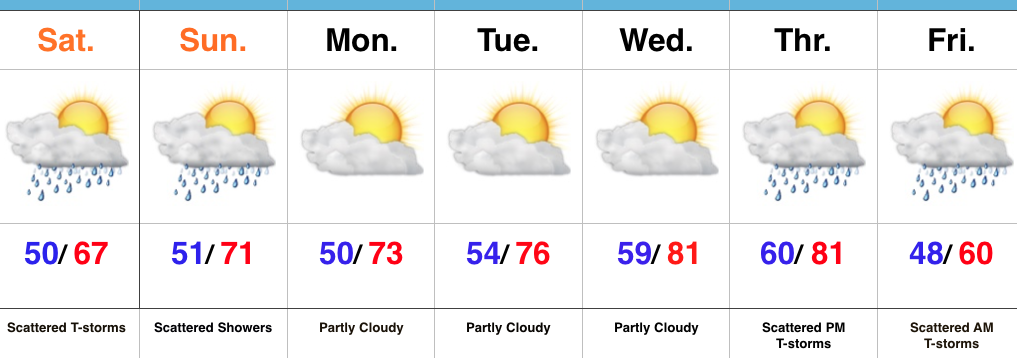
Slow Improvements…The “cut off” upper low that’s plagued the region for the past few days will slowly begin to lift north this weekend. Eventually it’ll get absorbed into the westerlies and get outta’ here! The end result will be a slowly improving weekend. Rain coverage will be greater today than Sunday, but less than Friday! 🙂 Slow moving showers and embedded thunder will be most numerous this afternoon before slowly diminishing tonight. While we’ll have to maintain mention of a shower Sunday, most folks will remain dry.
The work week will get off to a dry start along with moderating temperatures. Highs by mid week will reach the lower 80s as a southwesterly air flow dominates ahead of an approaching strong autumn front.
While timing still needs to be fine tuned, we’re focusing in on the cold front passing through central IN Friday morning. Ahead of the boundary, scattered showers and thunderstorms can be expected followed by an abrubt NW wind shift and a MUCH cooler air mass for the weekend. Speaking of cool, it wouldn’t surprise us to see some neighborhood lows into the upper 30s next weekend.
It is October, after all…
Upcoming 7-Day Precipitation Forecast:
- Snowfall: 0.00″
- Rainfall: 0.50″ – 0.75″ (locally heavier totals)
Permanent link to this article: https://indywx.com/welcome-to-october/
Sep 29
Cool, Damp Open To The Weekend…
As we get set to open the weekend, our weather pattern remains unchanged from the past couple of days. The Ohio Valley will continue to be dominated by a cut off area of low pressure sitting and spinning overhead. Unseasonably cool air, along with periods of showers will be the result. Similar to Wednesday, stronger showers could contain small hail, particularly during the afternoon.
 Steadiest and most concentrated rain appears to come during the morning hours Friday. Here’s what the radar may look like predawn and mid morning Friday. Rain will be tracking west or southwest (pivoting around the upper low).

 Additional scattered showers and embedded thunder will remain in our forecast Saturday.

In general, additional rainfall should be in the 0.50″-1″ range, but there will be isolated heavier totals under more persistent rain bands.

It’ll be a continued cool stretch with highs both Friday and Saturday in the mid 60s (at best).
 The second half of the weekend certainly looks like the better of the two, but we caution that these cut off lows can be fickle and surprises can result in regards to timing. At any rate, a drier pattern will build in early next week, along with moderating temperatures.
Looking ahead, a significant storm system looms just beyond the 7-day that will require our attention in the days ahead.
Permanent link to this article: https://indywx.com/cool-damp-open-to-the-weekend/