Client Brief: Freezing Rain Arrives Pre-Dawn Friday…

Type: Impactful wintry weather

What: Freezing rain/ icy glaze

When: 2a – 1p Friday

Temperatures: 25° to 30° (location dependent, please see below)

Wind: East 5-15 MPH

Blowing/ Drifting: Non-existent

Pavement Impacts: Salting will be required

Summary: After a dry New Year’s Eve, moisture will advance north as a surface low tracks from the northwestern Gulf Coast into the Ohio Valley. As the precipitation arrives (around or just after midnight for far southwestern IN before spreading north, reaching Indianapolis by 4a, and north-central Indiana by 6a), it’ll encounter a shallow layer of cold air entrenched at the surface. Several hours of freezing rain can be expected north of a line from Terre Haute, Bloomington, and Cincinnati Friday morning where temperatures will remain below freezing the longest. South of that line, only a brief period of icing is expected before a transition to a cold rain. Further north, especially along and north of the I-70 corridor, temperatures will fall into the middle to upper 20s tonight and slowly rise into the lower 30s by late morning. All of the state will “warm” above freezing by Friday afternoon with any lingering moisture falling as a plain ole rain. Beforehand, an icy glaze is expected to develop predawn Friday and travel will be difficult in places- especially from central IN and points north. If at all possible, we recommend delaying travel until afternoon as conditions should slowly begin to improve by that point.

Confidence: High

Next Update: This afternoon

Client Brief: Widespread Snow Builds In Overnight Tuesday – Wednesday; Slippery Travel Expected Wednesday AM…

Type: Impactful wintry weather

What: Accumulating snow

When: Late Tuesday night & Wednesday

Temperatures: Upper 20s – lower 30s

Wind: NE 10-20 MPH early in the event, shifting to the NW and decreasing to 5-10 MPH Wednesday

Blowing/ Drifting: Minimal 

Pavement Impacts: Salting and plowing required

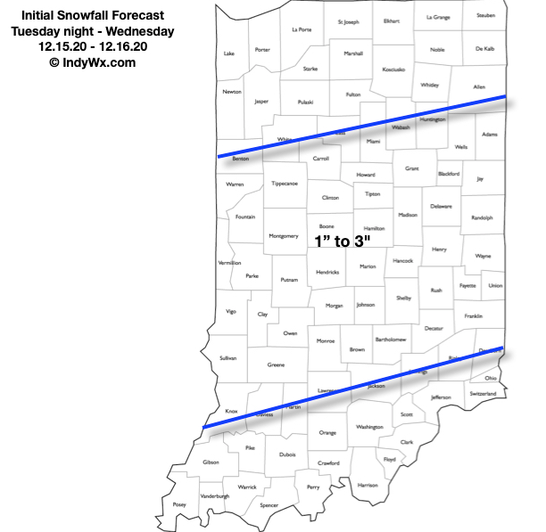
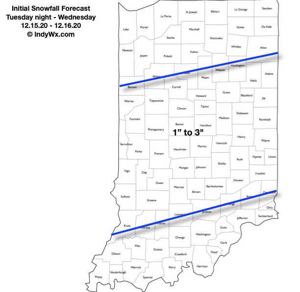
Summary: We don’t see any need to change our early stand on this event (originally issued Saturday morning). Data over the weekend trended away from the heavier snowfall amounts falling across our area only to have moved back to the snowy idea over the past 12-24 hours. Though while never expected to be a blockbuster event here, we always felt this was a classic setup to produce widespread accumulating snows across the region. The snow shield will lift northeast across the region overnight Tuesday into predawn Wednesday. We expect an arrival into the Indy metro and surrounding ‘burbs between 1a (southwest) and 3a (northeast). Once the snow arrives, it’ll settle in for the long haul, continuing (light to moderate intensity) for the better part of the daytime hours. Unfortunately, we fully expect slick roadways for the Wednesday morning rush. The snow will eventually end (southwest to northeast) between 3p and 7p Wednesday. We have no changes to our initial snowfall map below, first issued Saturday morning.

Confidence: High

Next Update: Tuesday morning (video package)

Client Brief: Eyeing 1st Widespread Accumulating Snow Of The Season…

Type: Impactful wintry weather

What: Accumulating snow

When: Tuesday night & Wednesday

Temperatures: Lower 30s

Wind: NE 10-20 MPH early in the event, shifting to the NW and decreasing to 5-10 MPH Wednesday

Blowing/ Drifting: Minimal

Pavement Impacts: Salting and plowing required

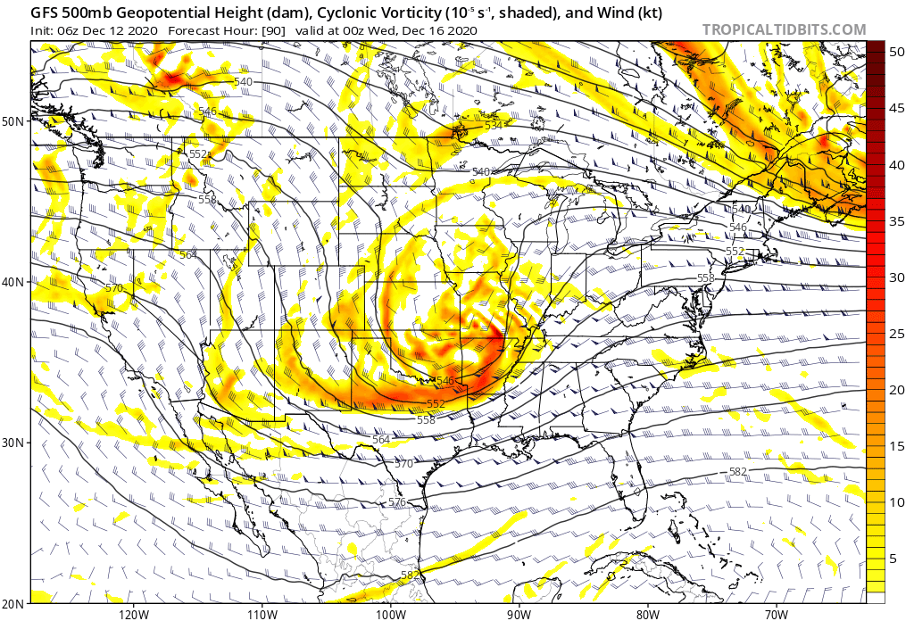
Summary: An area of low pressure will move across northern Texas (Monday night and Tuesday morning) northeast into the lower Ohio Valley (Wednesday morning). In response to this feature, a secondary surface low will form in the northern Gulf of Mexico Tuesday night and it’s this surface low that will eventually “steal the show” moving northeast and being located off the Carolina coast Wednesday before eventually blowing up into a good ole fashioned nor’easter Wednesday night and Thursday. Before this energy transfer takes place, we should see a stripe of accumulating snow extend northeast into the Ohio Valley Tuesday night and Wednesday. From this distance, it appears as if central IN is in store for the 1st widespread snow event of the season, but the devil’s still in the details. We’ll have to monitor the energy transfer closely. Additionally, it’ll be important to keep eyes on the developing Gulf low. Should this system generate convection in more rapid fashion than currently thought, it would steal some of the moisture from the initial low into the OHV. As it is, the early thinking here is that this is a 1″ to 3″ type event for our immediate region. Should the Gulf low organize a little slower, the possibility is there for heavier totals. Widespread snow should diminish and come to an end late Wednesday morning (west) and by afternoon (east). Thursday and Friday look dry and cold.

Confidence: Medium

Next Update: This afternoon (video package)

Client Brief: “System” Snow Transitions To Lake-Effect…

Type: Impactful Wintry Weather

What: Accumulating Snow/ Wind

When: Today through Tuesday Morning

Temperatures: Upper 20s to lower 30s

Wind: NW 15-20 MPH; Gusting to 35 MPH

Blowing/ Drifting: Moderate, especially with late afternoon-evening lake-effect snow band.

Pavement Impacts: Salting required; plowing required within lake-effect snow band.

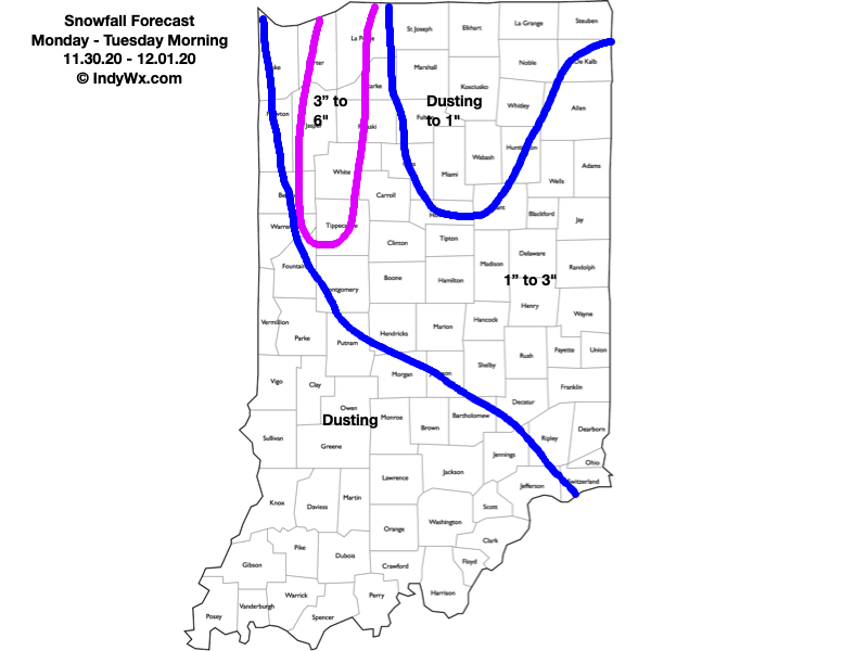
Summary: We’ll undergo a transition from “system” snow (mostly light) this morning into early afternoon to a more localized, but robust lake-effect snow event late afternoon and this evening. At least for central portions of the state, this is the better opportunity for accumulating snow. As temperatures continue to fall and the wind direction becomes better aligned, a band of lake effect snow is expected to develop initially across northwestern Indiana late morning. It’s this band of snow that should continue to get better organized and heavier as we move into late afternoon and the evening hours and be driven well inland. Eventually, this lake snow band should reach areas as far south as Indianapolis (and surrounding ‘burbs) by late afternoon, potentially including the 5 o’clock rush for parts of the city. Snowfall intensity within this band is expected to be heavy enough to whiten roadways and create slick spots. For most this will only last an hour or two before the band pivots east and impacts east-central Indiana for a longer period of time into the overnight and early Tuesday morning. If you find yourself under this lake effect snow band, a quick 1″ to 2″ can be expected

Confidence: High

Next Update: Tonight (video package)

Client Brief: Sunday Night – Monday System…

Type: Impactful Wintry Weather

What: Accumulating Snow/ Wind

When: Sunday night and Monday

Temperatures: Low-Mid 30s

Wind: N 15-20 MPH; Gusting to 35 MPH

Blowing Drifting: Minimal to Moderate in lake enhanced zone, as well as east-central IN

Pavement Impacts: Salting required; plowing likely required in lake enhanced zone, as well as east-central IN

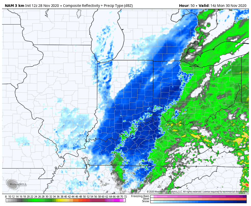
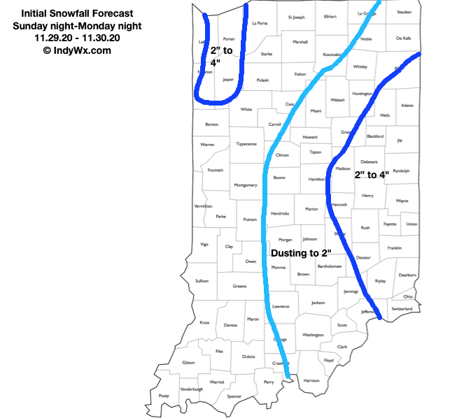
Summary: While not nearly as robust as what guidance earlier this week printed out, the season’s first widespread wintry event looms Sunday night into Monday. This is a byproduct of phasing between the southern and northern jet stream (initially set off by the evolving strongly positive PNA), but there are important differences in the speed of the initial vort. max being a bit more progressive that will keep this from bombing out like earlier guidance showed. Consequently, this will result in a much further east system (may still not have seen that eastward trend finish). While our forecast specifically focuses on Indiana, if you have travel plans east of here into Ohio early next week, please pay special attention to the local National Weather Service products as impacts will be greater from heavy snow and strong winds.

Locally, we anticipate precipitation overspreading central Indiana (from southwest to northeast) around, or just after, midnight Sunday night. Initially, this should be in the form of a cold rain before precipitation transitions to wet snow prior to sunrise. Moderate snow should be falling across east-central Indiana from the mid morning hours Monday into early afternoon. Additionally, by this point, a more organized band of lake-effect snow should be firing up off Lake Michigan. This is a bit of a wild card as a combination of ingredients favor a pretty robust lake snow band making it further south than typical. As the wind direction veers towards more of a northwesterly flow late Monday afternoon and evening, it’s possible this lake effect snow band pivots into the Indy metro and surrounding ‘burbs. We’ll keep a close eye on this as time draws closer. Within this snow band, heavier accumulations are possible. Snow showers will continue into Tuesday morning before diminishing.

Confidence: Medium

Next Update: Tonight (video package, including longer range update).