You must be logged in to view this content. Click Here to become a member of IndyWX.com for full access. Already a member of IndyWx.com All-Access? Log-in here.
Category: Client
Permanent link to this article: https://indywx.com/2020/01/25/video-talking-saturday-snow-accumulation-looking-ahead-to-another-busy-week/
Jan 24
Today’s Rain Gives Way To Saturday Snow…
A big upper level low will “pinwheel” across the state later this evening. On the front end of the system, a southerly flow will deliver periods of rain today. At times, rain will take on a steadier nature and at others, only light rain and drizzle is anticipated.
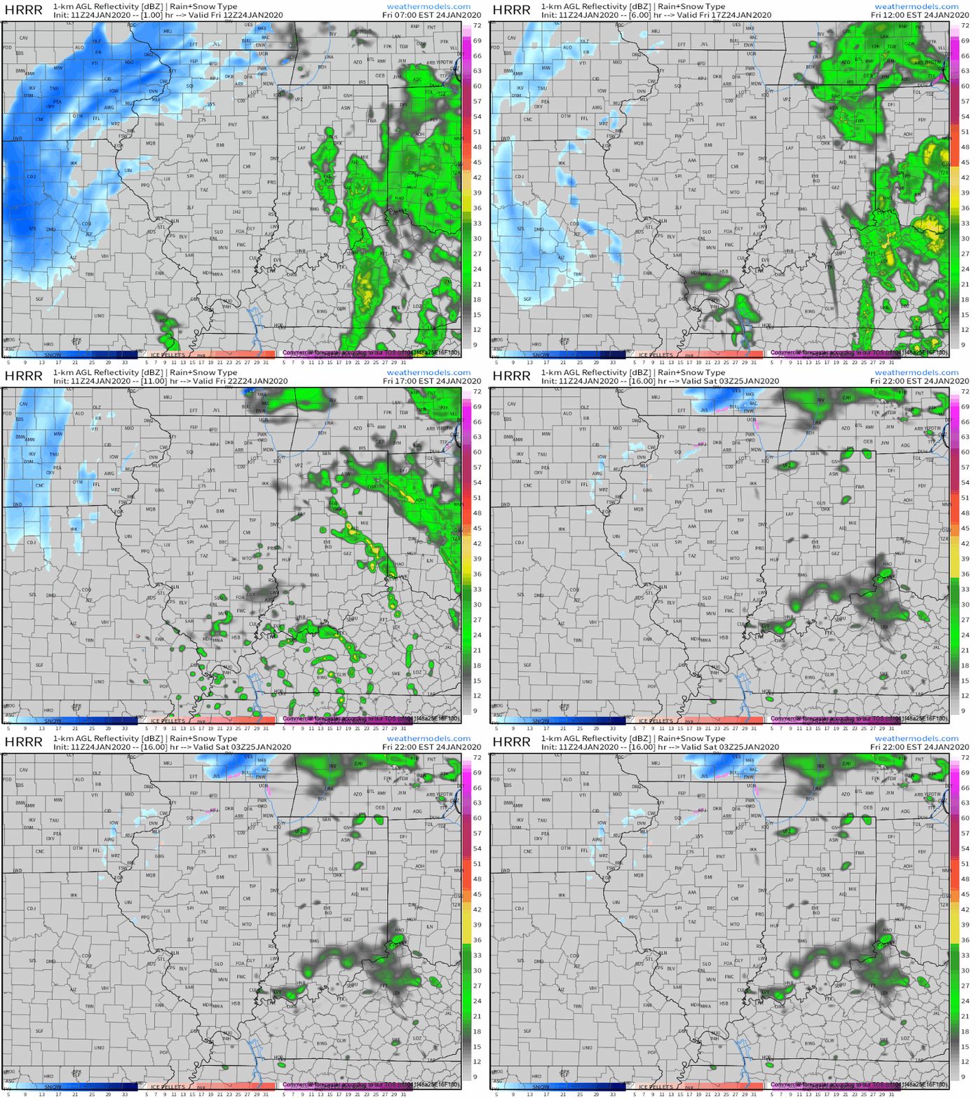
Heaviest rainfall will occur across the eastern third of the state, including amounts around 0.50″.

As the upper low continues to track northeast, we’ll get in on the northerly flow of this feature tonight into Saturday. Secondly, a lobe of moisture will pivot into central and northern Indiana Saturday morning. With the colder air in place, the bulk of this should fall in the form of snow.
We think snow will move into the area around, or just before, sunrise Saturday and remain through the bulk of the day. Periods of moderate snow will fall with embedded bands, especially across north-central Indiana.
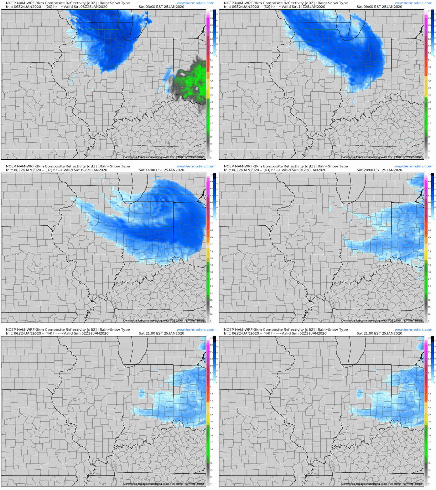
As for accumulation Saturday, we think in and around Indianapolis can expect a coating to up to 1″ of wet, slushy snow Saturday (no impacts to pavement expected). Northern suburbs (Zionsville, Carmel, Noblesville, etc.) and points north can expect 1″ to 2″ Saturday with the potential of slushy accumulation on untreated pavement surfaces.
The snow will depart Saturday night and we’ll get back to dry conditions Sunday.
Permanent link to this article: https://indywx.com/2020/01/24/todays-rain-gives-way-to-saturday-snow/
Jan 23
Short-Term Update On Saturday’s Snow; Long Range Look Into February…
You must be logged in to view this content. Click Here to become a member of IndyWX.com for full access. Already a member of IndyWx.com All-Access? Log-in here.
Permanent link to this article: https://indywx.com/2020/01/23/short-term-update-on-saturdays-snow-long-range-look-into-february/
Jan 23
VIDEO: Plenty Of Wintry Mischief- Timing Out Storm Systems To Close January And Open February.
You must be logged in to view this content. Click Here to become a member of IndyWX.com for full access. Already a member of IndyWx.com All-Access? Log-in here.
Permanent link to this article: https://indywx.com/2020/01/23/video-plenty-of-wintry-mischief-timing-out-storm-systems-to-close-january-and-open-february/
Jan 22
Hudson Bay Ridge Forces Stormy Times For The Region: Analyzing Where The Heavy Snow Zone Sets Up With Storm #1…
You must be logged in to view this content. Click Here to become a member of IndyWX.com for full access. Already a member of IndyWx.com All-Access? Log-in here.
Permanent link to this article: https://indywx.com/2020/01/22/hudson-bay-ridge-forces-stormy-times-for-the-region-analyzing-where-the-heavy-snow-zone-sets-up-with-storm-1/
Jan 21
Catching Up On A Tuesday Evening And Looking Ahead…
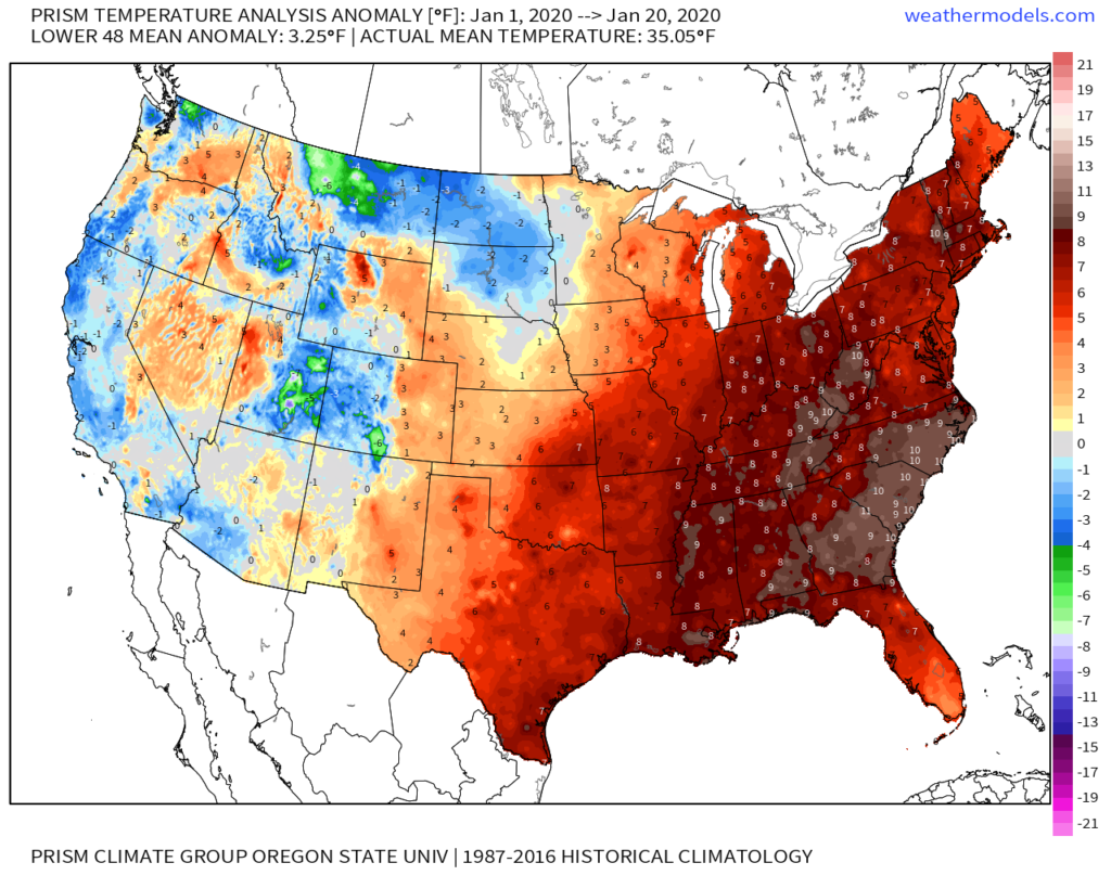
January is flying by! With only 10 days left in the month, Indianapolis is running a whopping 8.2° above normal along with more than 3″ above normal in the precipitation department (unfortunately for snow lovers, this excess moisture has fallen primarily as rain, as IND is running a deficit of 5.2″ in the snowfall department).
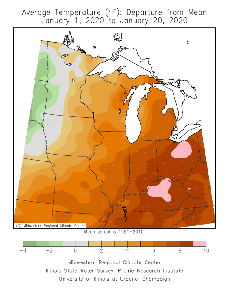
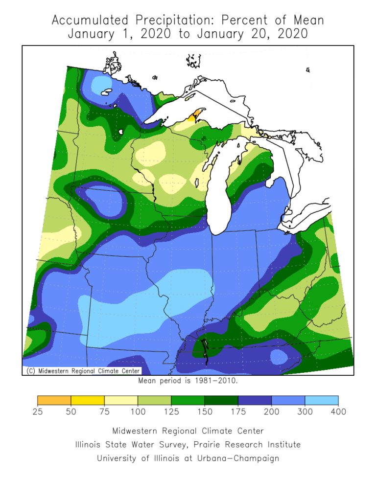
On a broader scale, here’s a look at the current month-to-date temperature anomalies for the Lower 48 as a whole:
As a refresher, our January forecast looked like this:
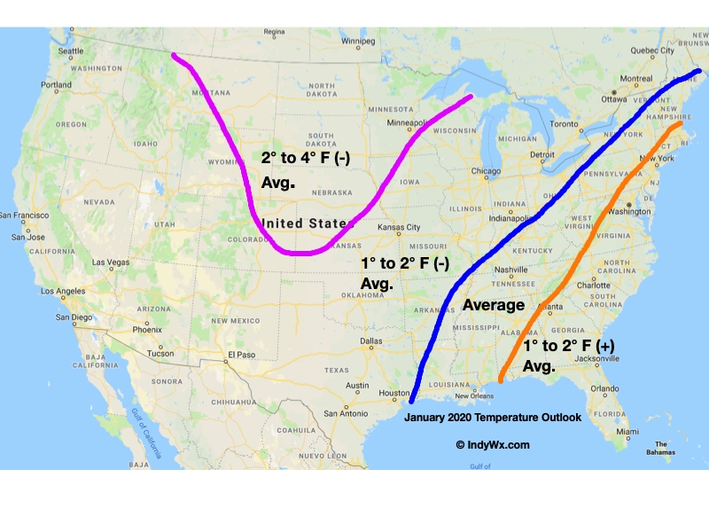
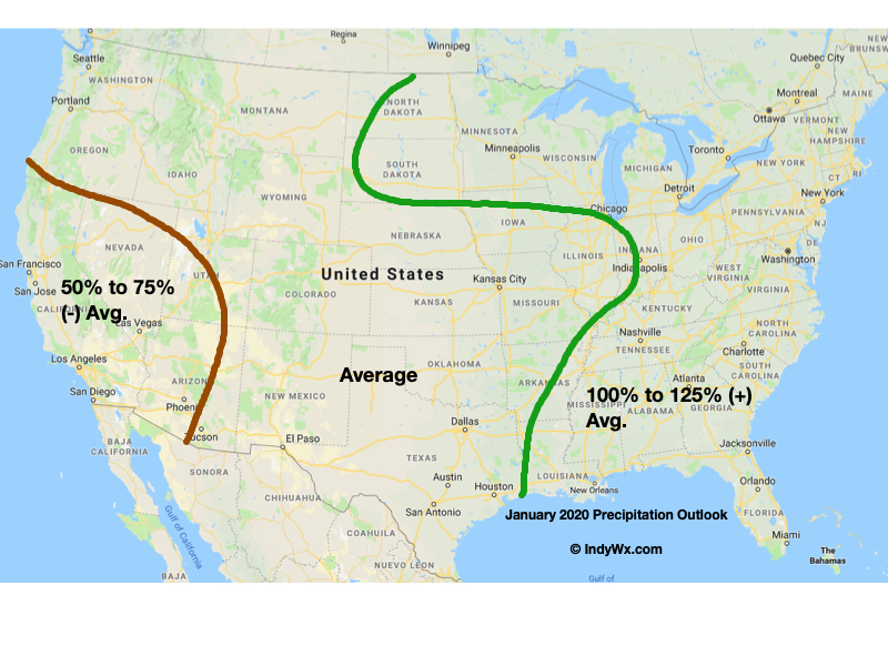
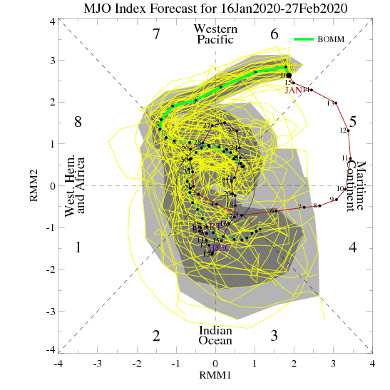
The baseline of this thinking had to do with the idea we had that the MJO would roll out of the warm phases (5 and 6) and strongly into the colder phases after mid-month. Secondly, the other driver was the thought that the current SST configuration in the north Pacific would “force” a negative EPO as the winter season matured.
While the MJO did, indeed, rumble out of the warmer phases just after mid-month, the EPO has not cooperated. Furthermore, instead of the MJO tracking into Phases 8, 1, and 2, it appears it wants to go into the “null” phase to figure out its ultimate destination for the 2nd half of winter (this will be key with Feb. and March). While this doesn’t necessarily support warmth, it doesn’t offer enough ammo to fight the warm signal from the strongly positive EPO.
Now that we’re beginning to turn the page to the 2nd half of winter, there are other items to begin paying closer attention to. In addition to the EPO and MJO, some of these features include the AO, NAO, and PNA. With that said, to drive more of a consistent colder than normal theme, we need to get the EPO at least into the neutral range as some of the other ingredients noted above transition into more favorable colder phases. With a strongly positive EPO, it’ll be tough to sustain well below average temperatures.
With all of that said, all hope is not lost for winter lovers. Climatology speaking, we’re in the coldest time of the year. Even in “marginally” cold patterns, or even “warm” patterns this time of year, wintry issues can create headaches. Secondly, it’s worth paying close attention to the MJO over the next couple of weeks as some of the data wants to take things out of the null phase and transition towards the traditionally colder phases of 8, 1, 2, and 3.
As it is, the next couple of weeks should present a fairly active storm track across the region. In the face of what should truly be a “torch” pattern, the saving grace (at least for fans of winter weather) has to do with the strong Hudson Bay ridge and tendency this kind of pattern has to force stormy times underneath. While far from a “slam dunk,” these kind of patterns can produce- even in the face of a strong positive EPO.
If you had to choose, would you rather have a bitterly cold and dry regime or seasonably mild with at least being on the playing field for wintry mischief over the next couple of weeks?
More in the AM, friends. Make it a relaxing evening! 🙂
Permanent link to this article: https://indywx.com/2020/01/21/catching-up-on-a-tuesday-evening-and-looking-ahead/
Jan 21
VIDEO: Detailed Discussion Around Our Pending Friday-Saturday Storm System…
You must be logged in to view this content. Click Here to become a member of IndyWX.com for full access. Already a member of IndyWx.com All-Access? Log-in here.
Permanent link to this article: https://indywx.com/2020/01/21/video-detailed-discussion-around-our-pending-friday-saturday-storm-system/
Jan 20
Another Late Week Storm…
Relatively quiet weather will be with us through the 1st half of the work week and this will allow us to focus on what’s coming down the road. A complex system will begin to impact central Indiana Thursday night or Friday morning and continue through the day Saturday.
What initially began to tip us off to this potential had to do with the positive (upper ridge) over Hudson Bay. That’s still the case this morning, but now modeling is better able to see the associate storm threat “underneath.”
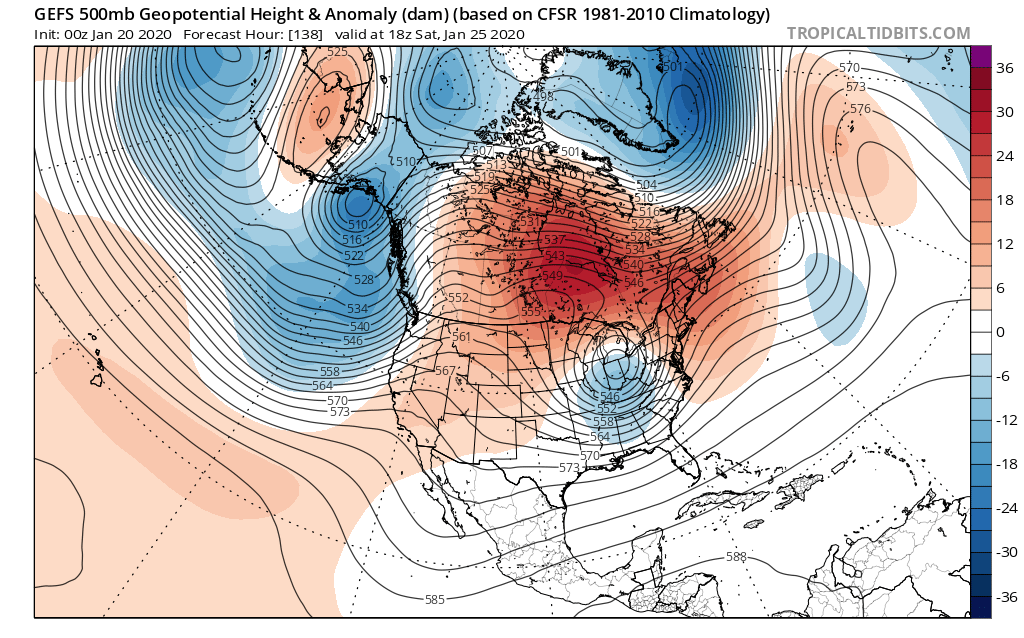
The question now has to do with how organized this feature is. Should it get it’s act together, this is the type pattern that an associated storm should be able to spread heavy, wet snow from the central Plains, Ohio Valley, and into the Mid-Atlantic and Northeast (even with marginally cold air available).
There’s also the possibility the system doesn’t organize until it reaches the Mid-Atlantic region. If that’s the case, we’re only looking at mixed rain and snow showers in the Friday-Saturday time period (light rainfall amounts and little, if any, snow accumulation).
It’s a complex pattern that will require close attention over the next few days. Stay tuned. A more in-depth video update will arrive this evening.
Permanent link to this article: https://indywx.com/2020/01/20/another-late-week-storm/
Jan 19
Week-Ahead Outlook: Bitter Cold To Open; Interesting Storm System To Finish…
You must be logged in to view this content. Click Here to become a member of IndyWX.com for full access. Already a member of IndyWx.com All-Access? Log-in here.
Permanent link to this article: https://indywx.com/2020/01/19/week-ahead-outlook-bitter-cold-to-open-interesting-storm-system-to-finish/
Jan 18
VIDEO: Frigid Sunday; Time To Track The Next Feature…
You must be logged in to view this content. Click Here to become a member of IndyWX.com for full access. Already a member of IndyWx.com All-Access? Log-in here.
Permanent link to this article: https://indywx.com/2020/01/18/video-frigid-sunday-time-to-track-the-next-feature/
