
You must be logged in to view this content. Click Here to become a member of IndyWX.com for full access. Already a member of IndyWx.com All-Access? Log-in here.
Category: CFSv2
Permanent link to this article: https://indywx.com/video-storms-ignite-ahead-of-sharply-colder-air-friday-pm-looking-into-early-november/
Oct 13
VIDEO: Cold Shot To Close The Week; Prospects Are Rising For A More Beneficial Rain Event Early Next Week…
You must be logged in to view this content. Click Here to become a member of IndyWX.com for full access. Already a member of IndyWx.com All-Access? Log-in here.
Permanent link to this article: https://indywx.com/video-cold-shot-to-close-the-week-prospects-are-rising-for-a-more-beneficial-rain-event-early-next-week/
Sep 17
Long Range Update: Extended Dry Pattern Rolls Along; New Winter Seasonal Data Is In…
Unfortunately there likely won’t be any significant changes to our precipitation pattern until late autumn and winter. Until then, we’ll have to take any drop of rain we can find. Once the pattern flips though, it may do so in quick and rather dramatic fashion (still expecting a wet winter).
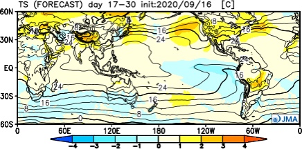
The consensus of long range data shows the dry pattern continuing over the upcoming few weeks, including the JMA Weeklies, CFSv2 Weeklies, and ensemble products.

Analogs and other teleconnections support this dry theme. At least in the immediate range (through mid October) the only way to bust up this dry pattern is to get tropical moisture involved.
The new JMA Weeklies maintain the ‘mean’ ridge position across the West for the majority of the upcoming few weeks, but there will likely be attempts to expand the ridge across the northern tier Week 2 and 3 that would lead to at least transitional periods of much warmer air, after the cool period in the short term.


The model sees the ridge expanding Weeks 3-4 and the associated warmth that spreads east after the chilly regime.

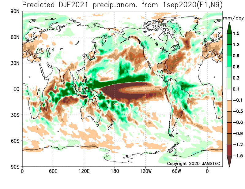
The new JAMSTEC seasonal data is also in and maintains a warm look this winter. A lot of this has to do with an expected persistent southeastern ridge. We agree with this but, as is the case each winter, there will be challenges that have to be dealt with.
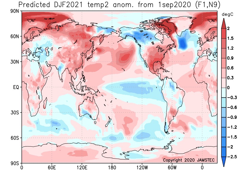
We also agree with the active storm track through the Ohio Valley and associated well above normal precipitation in the December through February period.
Permanent link to this article: https://indywx.com/long-range-update-extended-dry-pattern-rolls-along-new-winter-seasonal-data-is-in/
Sep 03
Long Range Update: Making Sense Of The “Noise” Into Mid-Late September…
Over the past couple of days we’ve noted a tremendous amount of chaos within the medium range forecast models for next week. At times, the American data was suggesting October-like chill while the European data painted a picture that would make mid-summer proud. The end result will likely end up being a blend of the two extreme solutions (cooler, most certainly, but not to the extent once forecast off the GFS- and a far cry from the extreme heat shown from the European). We’ll handle that with our short to medium term updates from here on out.
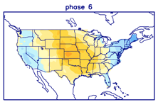
As we look ahead to mid and late September, the baseline of our forecast remains unchanged and that’s the idea that the MJO will move into Phases 5 and 6. At first, this is a cool phase for the time of year, but once to around the 18th-20th, we flip the script to a drastically warmer period, compared to average. Note the (2) MJO analogs below:

This is very similar to what the latest CFSv2 and European Weeklies show:


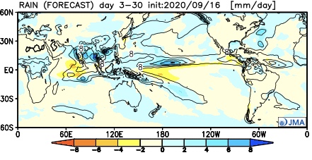
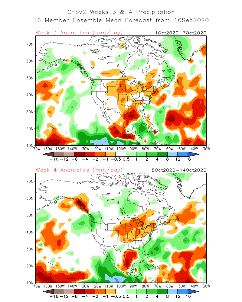
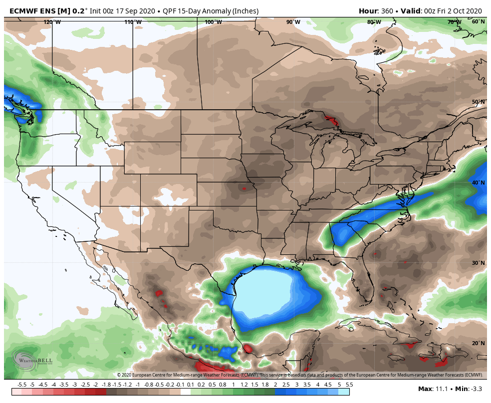
After what will likely be a much more active and wetter week ahead, the following couple of weeks take on a dry look from the models:


Interestingly, Phase 5 of the MJO is also a dry phase this time of year, locally:

Much more throughout the weekend!
Permanent link to this article: https://indywx.com/long-range-update-making-sense-of-the-noise-into-mid-late-september/
Aug 30
September 2020 (And Fall) Outlook…
Well here we are on the eve of meteorological fall and, right on cue, there’s a change on the horizon in the overall weather pattern. Does the quick start to a more autumn-like feel early and mid September continue into late month, or for that matter October and November? Let’s look at September first:
I. MJO will remain active- moving out of Phase 2 and into 3, 4, 5, and 6.
II. Tropics should remain busy with more of an East Coast threat.
III. West looks to remain hot and dry.

Note the precipitation and temperature patterns associated with the MJO phases this time of year:
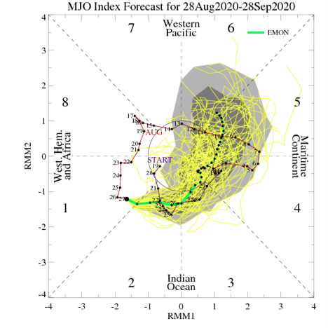


The next couple of weeks will feature multiple cold fronts sliding through the region and each will provide progressively cooler air. The front coming through around Labor Day may even result in the hoodies having to be pulled out for the first time, including an early October-like feel. BUT- note how the MJO wants to rumble into Phases 5-6 towards late month. These will likely lead to a warmer pattern around Sept. 20th (give or take a day or two) through the remainder of the month.
As we broaden the spectrum a bit and focus on September through November, let’s start by taking a look at how the oceans may impact the pattern:

Most models suggest La Nina will peak late fall or early winter before giving way to La Nada by spring.

Aside from the upwelling associated with Laura, most of the Gulf of Mexico and certainly off the East Coast remains much warmer than normal. Unfortunately, this, along with other favorable conditions in the main development region (MDR) will likely continue to promote a hyperactive 2nd half of the tropical season. The other impact will likely be a warmer than normal fall season along the eastern seaboard, bleeding back into areas west of the Appalachians. Furthermore, we think the MJO will lean more towards Phases 6-8 for mid and late autumn.
The blend of the CFSv2 and European seasonal data sees a similar forecast to what we have out for September for the autumn, as a whole:

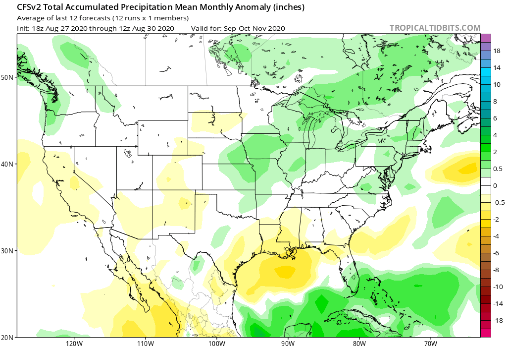
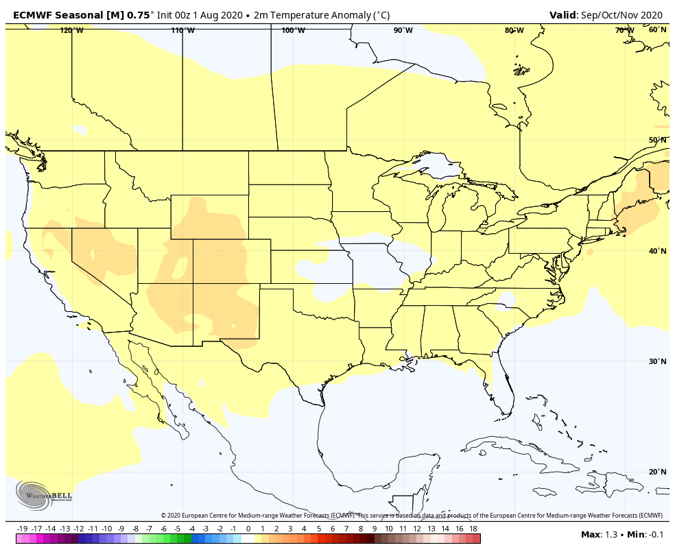
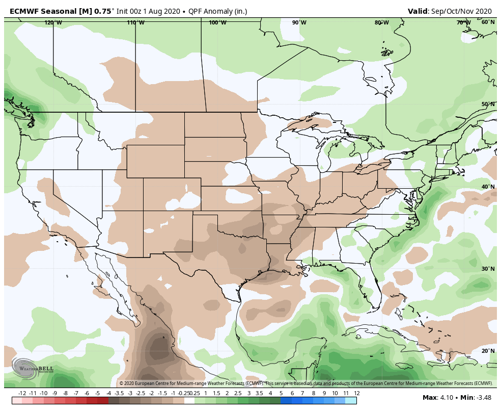
We believe fall 2020 will run slightly warmer than normal for our immediate region with the greatest spot for cooler anomalies to show up throughout the central Plains. After what we believe will be a wet September, things may take a turn for the drier in October before flipping back to wet in November. We prefer the way the CFSv2 handles the precipitation pattern compared to the European.
Next seasonal outlook we produce? Our annual winter package. Tick tock…
Permanent link to this article: https://indywx.com/september-2020-and-fall-outlook/