Updated 02.13.21 @ 2:31p
You must be logged in to view this content. Click Here to become a member of IndyWX.com for full access. Already a member of IndyWx.com All-Access? Log-in here.

Feb 13
Updated 02.13.21 @ 2:31p
You must be logged in to view this content. Click Here to become a member of IndyWX.com for full access. Already a member of IndyWx.com All-Access? Log-in here.
Permanent link to this article: https://indywx.com/video-memorable-week-ahead-for-inwx-winter-weather-lovers/
Feb 12
Updated 02.12.21 @ 5:50p
You must be logged in to view this content. Click Here to become a member of IndyWX.com for full access. Already a member of IndyWx.com All-Access? Log-in here.
Permanent link to this article: https://indywx.com/video-use-the-weekend-to-prepare/
Feb 12
Updated: 02.12.21 @ 7:34a
Use This Weekend To Prep…The short-term portion of this forecast is relatively quiet. Take advantage and prepare for significant winter weather next week. We may even see a few breaks in the cloud cover today. All in all, look for mostly cloudy and continued cold conditions. Keep in mind, average highs this time of year should be close to 40°. We’ll be nowhere near that anytime soon. In fact, most days will feature high temperatures even colder than average lows for this time of year!
Reinforcing arctic air will penetrate the area Saturday and will likely kick up some light snow showers- especially during the afternoon. Light snow will remain a possibility Valentine’s Day, but “light” is the key word.
The more exciting part of this forecast comes at us as we open the work week. Surface low pressure will develop in the northwest Gulf of Mexico Sunday night and track northeast up along the Appalachians. This will spread a swath of snow into the Ohio Valley through the day Monday. It appears as if snow will become heavy at times Monday evening into the predawn hours Tuesday before tapering to light snow/ snow showers late Tuesday morning. This will be a much more powdery snow than we typically see with these Gulf storms, due to having truly arctic air involved with the storm. Gusty winds will create significant blowing and drifting issues throughout the early and middle portion of the work week.
That then leads us to the threat of another significant winter storm as we push into Wednesday night into Friday morning. We don’t want to get ahead of ourselves, but the threat is very real that this storm also deals out heavy impacts across the region with additional heavy snow possible during the aforementioned time frame.
We’d suggest using the weekend to prepare for the potential of two back-to-back “big deal” winter storms. We’ll be here through the weekend with additional updates.
Averages: H: 39/ L: 23° on the 12th –> H: 41°/ L: 25° on the 18th
Permanent link to this article: https://indywx.com/02-12-21-weather-bulletin-continuing-to-keep-close-eyes-on-next-week/
Feb 11
Updated 02.11.21 @ 7:55a
You must be logged in to view this content. Click Here to become a member of IndyWX.com for full access. Already a member of IndyWx.com All-Access? Log-in here.
Permanent link to this article: https://indywx.com/video-long-hours-in-the-forecast-office-ahead/
Feb 09
Updated 02.09.21 @ 7:15p
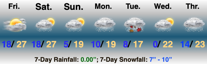
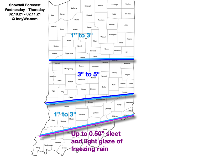
Type: Impactful Wintry Weather
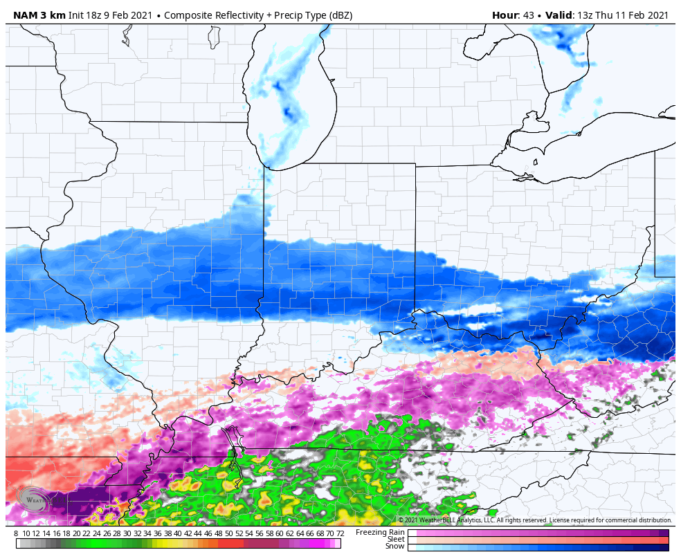
What: Accumulating snow
When: Late Wednesday morning through Thursday afternoon
Temperatures: 18° to 24°
Wind: NE 10 – 20 MPH and gusty
Blowing/ Drifting: Considerable
Pavement Impacts: Plowing and salting will be required
Summary: Wednesday will dawn with quiet conditions in place but snow will arrive into central Indiana by late morning. Initially, we’re only talking about light snow into the afternoon and evening. Snow will become more widespread and heavier throughout the “heart” of central IN during the overnight hours and Thursday morning before eventually giving way to lighter snow Thursday afternoon, eventually ending from west to east. Downstate, a mix of freezing rain, sleet, and brief snow is expected, including icy travel. Once again, this will be an efficient snow producer. Instead of snow ratios of 10:1 we expect closer to 15 to 20:1 ratios (similar to that of what southern parts of the state experienced Monday). The dry, powdery nature of the snow will combine with gusty northeast winds to create blowing and drifting issues by Wednesday evening through Thursday, especially in the open country. Gusty winds will persist Thursday night even as the snow comes to an end, extending the blowing and drifting concerns.
Confidence: High
Next Update: Wednesday morning (video)
Permanent link to this article: https://indywx.com/client-brief-another-round-of-accumulating-snow-on-deck-blowing-drifting-also-to-be-dealt-with/