Updated 02.03.21 @ 7:24p
You must be logged in to view this content. Click Here to become a member of IndyWX.com for full access. Already a member of IndyWx.com All-Access? Log-in here.

Feb 03
Updated 02.03.21 @ 7:24p
You must be logged in to view this content. Click Here to become a member of IndyWX.com for full access. Already a member of IndyWx.com All-Access? Log-in here.
Permanent link to this article: https://indywx.com/video-a-busy-winter-pattern-settles-in/
Feb 03
Updated 02.03.21 @ 8:19a
Best Day Of The Week…We can’t get too picky this time of year in the weather department. Long time fellow Hoosiers know to never take a day featuring sunshine for granted in early February. Though still chilly, given the pattern ahead, I’d recommend getting outside and enjoying some of those rays today.
A cold front blows into town Thursday and will deliver a chilly rain by the afternoon. As colder air rushes in on the backside of the system, rain will likely mix with and end as a period of snow across the northern half of the state Thursday evening. Though the moisture will be leaving as the cold air is arriving, we may still be able to squeeze out a dusting to 1″ of wet snow for northern areas.
Attention will then shift to an arctic wave that will move into the Ohio Valley this weekend. Snow will become widespread across the central Plains Friday evening into Saturday morning before expanding east into our neck of the woods Saturday afternoon into Sunday morning. With cold air in place, this will be a higher ratio snow event than we’ve seen so far this winter (“fluff factor” will be in full effect). Additionally, strong and gusty winds are expected during this time frame leading to blowing and drifting concerns. Stay tuned. We’ll take a stab at early accumulation numbers with this evening’s Client Video update.
Additional upper level energy will scoot through the region into early next week, keeping a supply of snow showers ongoing. While still cold, models have pushed back the truly dangerous cold until late week. Case of delayed, but not denied? Unfortunately think so…
Permanent link to this article: https://indywx.com/02-03-21-weather-bulletin-keeping-a-watchful-eye-on-the-weekend/
Feb 02
Updated: 02.02.21 @ 6:15p
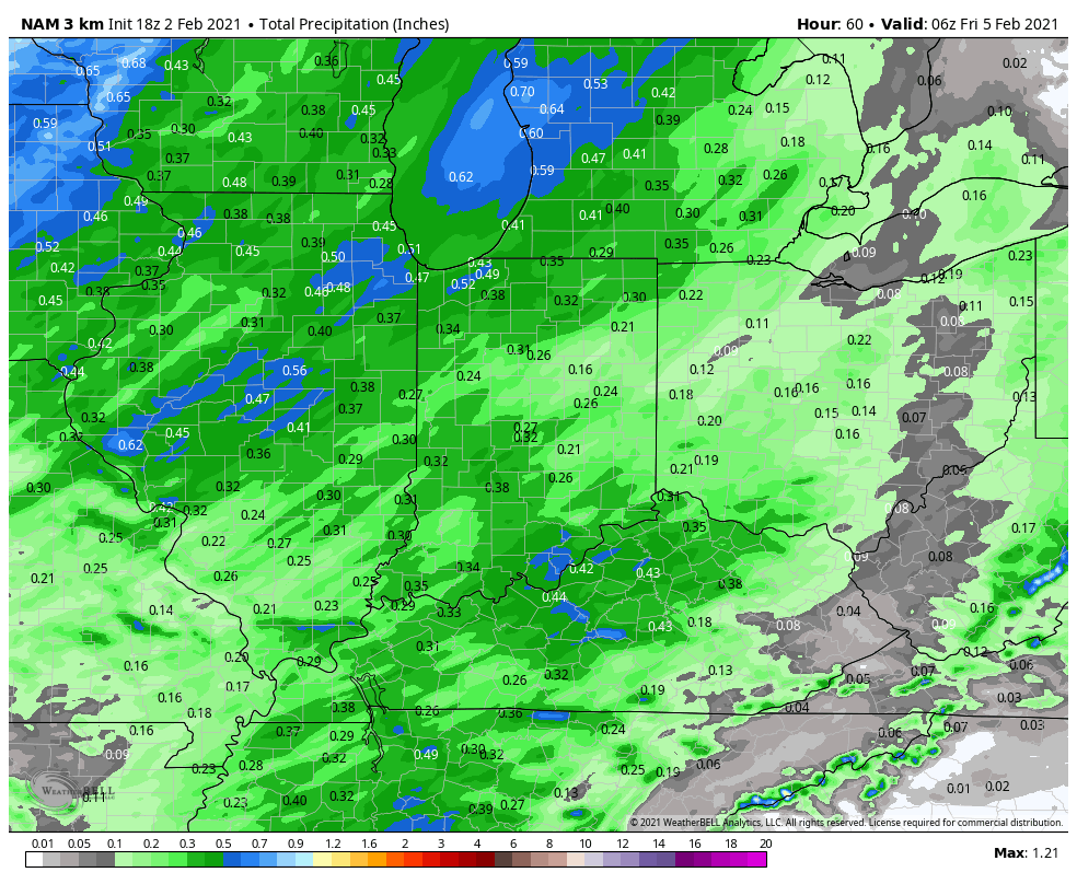
While we have a few flurries (thanks to a little help from Lake Michigan) flying this evening, the bulk of the upcoming 48 hours will be rather quiet across the region. The next item on the agenda will come in the form of a cold front Thursday afternoon. As of now we anticipate rain (perhaps a brief early mix, but this won’t be a big deal) to arrive into central Indiana between 11a-1p Thursday. Mostly light to, at times, moderate rain will continue into the evening hours before ending as a brief period of wet snow Thursday evening (again, little if any impacts are expected).
Rainfall totals between 0.25″ and 0.50″ can be expected Thursday PM with the passage of the cold front.
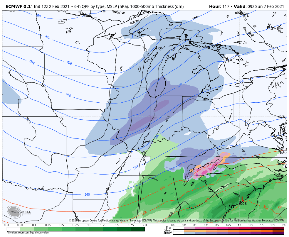
The relatively quiet regime should return Friday, but by this time all eyes will be focused on the 1st of (2) arctic frontal systems. The 1st of these arctic fronts will sweep through the state Saturday PM and early Sunday. As this takes place, an arctic wave is expected to form along the leading edge of the true arctic air Saturday evening. This should result in an expanding area of snow that originally develops in the central Plains Friday night/ Saturday morning before pushing east, northeast Saturday into Sunday. With the arctic air pouring into the region, this should be a high ratio type snow and blowing/ drifting issues will likely be more of a problem than with the majority of systems so far this season.
While this is all taking place, a secondary low pressure system should develop along the Carolina coast early Sunday morning and it’s this system that will likely become the primary “player on the field” late in the weekend or early next week. Before that though, the arctic wave will likely result in a stripe of accumulating snow from the central Plains into the Ohio Valley, including central Indiana (too early for specific amounts). This will lay the groundwork for the coldest air of the season early next week…
Snow removal clients, as well as those in the ag. industry should keep close tabs on the weekend forecast. While we’re not expecting a widespread heavy snow event, the combination of snow, wind, and eventual bitterly cold air will lead to significant impacts as we move forward.
I would plan on temperatures falling into the single digits below zero, along with wind chill values potentially approaching 20° below zero by early next week.
Stay tuned.
Permanent link to this article: https://indywx.com/never-trust-an-arctic-wave-accumulating-snow-prospects-growing-this-weekend/
Feb 25
During a month that’s running 2.5° above normal, many across central Indiana will be sitting at “average” snowfall once to Thursday morning (with the potential of some “bonus” snow for some Friday). Not too shabby, heh?! Let’s dig into some of the latest data. In short, our going forecast remains in good shape and now it’s time to watch the event unfold.
As we type this around 6:30p Tuesday evening, snow is increasing in intensity across northern Indiana and precipitation will continue to become more organized across IL throughout the evening. The bulk of central Indiana is only dealing with drizzle and light rain this evening. It’s a damp, chilly night, but there’s no threat to travel if you’re heading out to dinner or other events with the family.
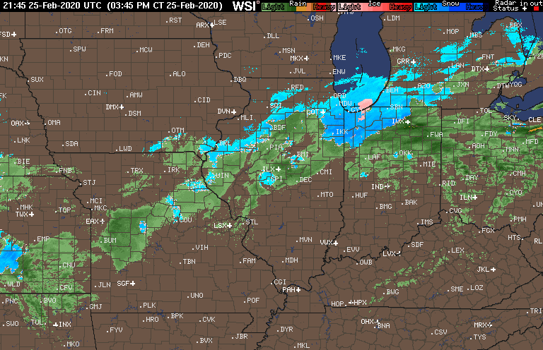
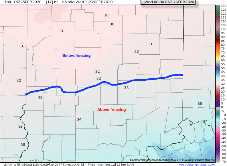
Colder air will continue to “ooze” into central Indiana throughout the night and as this takes place, a surface wave will develop south of the Ohio River. By 6a, the freezing line is expected to be just south of Indianapolis.
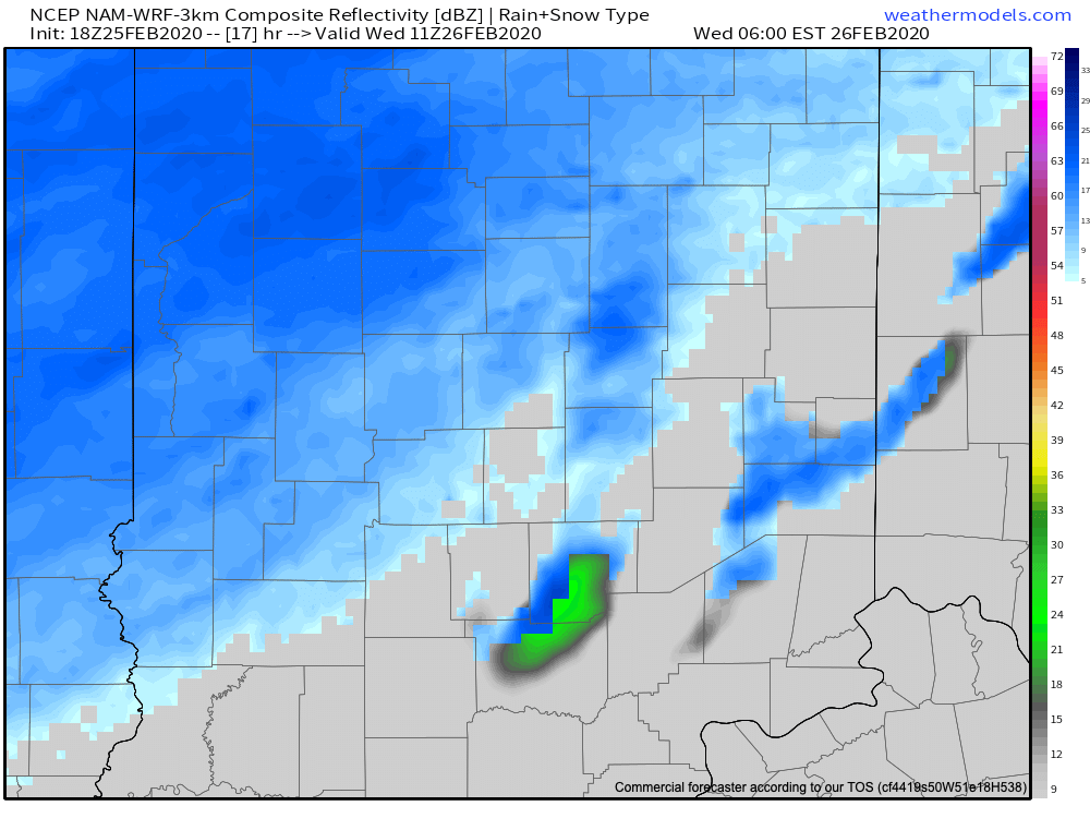
Light to moderate snow is expected to begin overspreading central Indiana in earnest around this time frame (earlier further north).
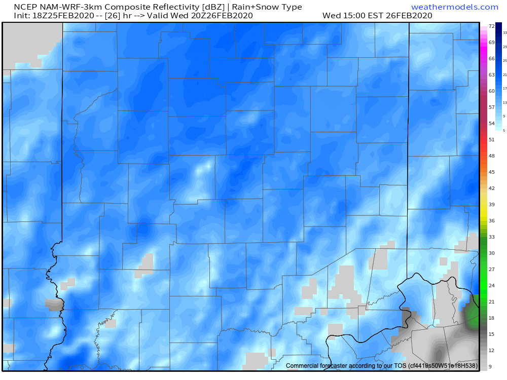
Snow will increase in overall intensity late morning into the afternoon hours (this is when we anticipate the greatest snowfall rates).
“System” snow will begin to diminish across central Indiana between 5p (west) and 7p (east), but we’ll have to monitor whether or not lake effect snow bands can make it as far south as portions of central Indiana tomorrow night as the wind flow backs around to the northwest and much colder air drives south.

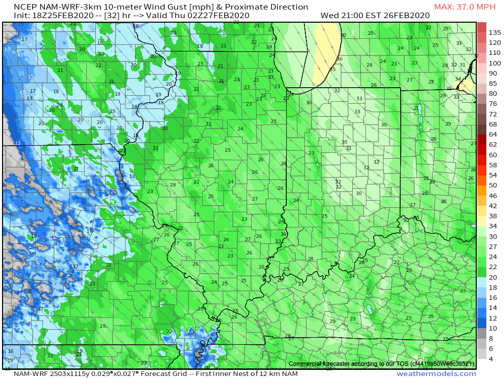
Speaking of wind, we still anticipate northwest winds to increase to 30 MPH+ Wednesday evening across the area. This will lead to considerable blowing and drifting tomorrow night of what should become an increasingly dry/ powdery snow towards the 2nd half of the event.
Things should quieten down through the day Thursday, but cold air (well below normal) will rule into the 1st half of the weekend. We continue to believe the coldest morning of the bunch will come Saturday with widespread middle 10s. Before that, and as mentioned above, we’ll have to monitor some additional snow prospects for some Friday (more on that in the AM :-))!
Until then, enjoy our midweek snow. Our ongoing snowfall forecast first issued last night remains in place.

Permanent link to this article: https://indywx.com/tuesday-evening-check-up-on-wednesdays-snow-event/
Feb 25
You must be logged in to view this content. Click Here to become a member of IndyWX.com for full access. Already a member of IndyWx.com All-Access? Log-in here.
Permanent link to this article: https://indywx.com/video-winter-storm-impacts-central-indiana-wednesday-into-thursday-morning/