Category: Autumn

Extremely Dangerous Severe Weather Outbreak Ahead…

Good morning!  We’re waking up to sunshine this morning after a round of rain and thunderstorms overnight.  Over 1″ of rain fell for many during the overnight period (1.53″ to be exact here at IndyWx.com HQ).

Unfortunately, skies now are clearing and this is only going to aid in the severe weather potential today, including some dangerous long-lived and strong tornadoes.

ECWVThis is a very rare November high severe weather risk day and must be taken seriously by all.

day1otlk_1300

The thinking here hasn’t changed in that we feel discrete super cells develop during the late morning and early afternoon before morphing into a squall line capable of producing damaging straight line wind. With the dynamics and energy in play here, any of these super cells could spawn a tornado. Additionally, it’s possible that a few of these tornadoes could be long tracked and very strong tornadoes.  The latest high-resolution simulated radar data shows this well.

hires_ref_indy_16

We still target a cold front passing through the region around, or just after, sunset and with this frontal passage the severe weather will come to an abrupt end.  The latest HRRR data shows this well as dew points begin to crash behind the cold front, indicative a much drier, cooler, and more stable air mass arriving tonight.

hrrr_dew2m_ky_12

Permanent link to this article: https://indywx.com/extremely-dangerous-severe-weather-outbreak-ahead/

Some Saturday Afternoon Thoughts…

We continue to monitor Sunday’s severe weather outbreak very closely.  Simply put, the latest data suggests all of central Indiana will be under the gun for a potentially dangerous and life threatening severe weather event Sunday.  The bullet points highlighted in our previous post haven’t changed, but we note tornado parameters may be even more impressive per latest data.  Unfortunately, I’m afraid multiple tornado touchdowns will be reported across central Indiana tomorrow afternoon, followed by a more widespread damaging straight line wind event mid to late evening.  Certainly please keep abreast of the latest watches and warnings that will come tomorrow.

Showers and thunderstorms will develop tonight, but will remain below severe levels.  The latest NAM simulated radar shows the developing showers and thunderstorms tonight.

hires_ref_ky_18

Fast forward to Sunday evening and we note a line  of severe thunderstorms moving through central Indiana, including a potential widespread damaging wind event.

hires_ref_ky_34

Also, just to let you know, we’re also monitoring next weekend for another possible big weather event.  This time we’re not talking severe weather, but possibly a major early season arctic attack…  The latest European model isn’t holding back.  Could a cold Thanksgiving week be shaping up?  We’ll monitor closely.

f192

Permanent link to this article: https://indywx.com/some-saturday-afternoon-thoughts/

Heavy Rain And Severe Outbreak Sunday

We continue to analyze the latest data concerning our pending severe weather episode ahead Sunday.  Today’s information continues to point towards the threat of not only a damaging straight line wind event, but the potential of multiple tornadoes across the central Ohio Valley.  The tornado threat would most likely occur with any individual super cells that develop Sunday afternoon.  The damaging straight line wind event would then be associated with what’s likely to be a squall line associated with the cold frontal passage Sunday night.  Needless to say, Sunday will be busy weather day across not only the Hoosier state, but for many folks across the Mississippi River Valley into the Ohio Valley.  Additionally, widespread heavy rain is also a good bet.  Let’s look at some data:

First, let’s look at some rainfall numbers.  The ECMWF (European forecast model) and GEM (Canadian forecast model) are the most aggressive with rainfall totals approaching the 2″ mark for many areas of central Indiana between Sunday and Monday.  The GFS isn’t as bullish, forecast a little more than half an inch on it’s latest run.  Officially we’ll go with a blend of all three models and suggest widespread 1″ type rains across central Indiana during the Sunday-Monday period.

ecmwf_tprecip_indy_21cmc_total_precip_east_15gfs_total_precip_east_15

Before we go further, we also want to highlight that winds will be strong and gusty Sunday even well away from any thunderstorms.  Winds will likely gust to 40-50 MPH simply by the tightening pressure gradient as surface low pressure begins to “bomb out” (rapidly intensify) on it’s journey into the Great Lakes region.

The dynamics are somewhat scary with this event and, as stated above, suggest not only an enhanced straight line damaging wind event, but also the potential of multiple tornadoes associated with any super cells that get going Sunday afternoon, well ahead of the squall line.  Despite a cold, dry air mass in place currently, the aforementioned strong southerly winds will help transport dew points into the lower to middle 60s come Sunday afternoon.  This will only help add fuel to the fire for storm development.

ecmwf_dew2m_indy_14

Let’s take a look at the official Severe Weather Outlook for Sunday, courtesy of the Storm Prediction Center.  Some highlights from their most recent discussion:

SOME UNCERTAINTY LINGERS...BUT TRENDS IN THE MEDIUM RANGE FORECAST
   GUIDANCE ARE INCREASINGLY SUGGESTIVE OF THE DEVELOPMENT OF AN
   ENVIRONMENT SUPPORTIVE OF AN OUTBREAK OF SEVERE THUNDERSTORMS ACROSS
   PARTS OF THE MIDDLE MISSISSIPPI VALLEY EASTWARD THROUGH MUCH OF THE
   OHIO VALLEY ON SUNDAY.
A 90+ KT 500 MB JET STREAK NOSING THROUGH THE OHIO VALLEY...COUPLED
   WITH STRENGTHENING SOUTHERLY WARM SECTOR 850 MB FLOW...PERHAPS IN
   EXCESS OF 70 KTS ACROSS PARTS OF THE OHIO VALLEY INTO THE LOWER
   GREAT LAKES...WILL CONTRIBUTE TO VERY STRONG DEEP LAYER WIND FIELDS
   AND SHEAR.  IT ALSO APPEARS INCREASINGLY PROBABLE THAT THIS WILL
   COINCIDE WITH AN INFLUX OF SEASONABLY HIGH MOISTURE CONTENT AT LEAST
   AS FAR NORTH AND EAST AS THE LOWER OHIO VALLEY...CONTRIBUTING TO
   SUFFICIENT CAPE FOR VIGOROUS STORM DEVELOPMENT.  SUPERCELLS WITH A
   RISK FOR TORNADOES WILL BE POSSIBLE...PARTICULARLY IN EARLY STAGES
   OF CONVECTIVE DEVELOPMENT...PERHAPS AS EARLY AS MID DAY ACROSS PARTS
   OF THE MIDDLE MISSISSIPPI INTO LOWER OHIO VALLEY VALLEY
EVENTUALLY...THOUGH...ACTIVITY PROBABLY WILL EVOLVE INTO A SQUALL
   LINE WITH DAMAGING STRAIGHT-LINE WINDS BECOMING THE MOST PROMINENT
   SEVERE THREAT.

day48prob

Permanent link to this article: https://indywx.com/heavy-rain-and-severe-outbreak-sunday/

No Secret Behind The Early Bitter Shots Of Air

As I write this, many Hoosiers are awaking to temperatures at downright bitter levels, despite the fact it’s only mid November.  The official low here at IndyWx.com HQ was a frosty 18 degrees and a far cry from the normal low of 37.

The early season bitter air mass has even settled in across portions of the Deep South and Coastal Plain.  Amazingly, snow was reported along the Carolina coastline last night (almost unheard of for mid November). Note the deep freeze penetrating far into the Deep South.  My home town of Auburn, AL dipped to a frigid 27 degrees this morning.  Again, very rare for so early in the season.

rtma_conus

It’s my job to look at what is behind these expansive early season bitter attacks of air (by the way, another bitterly cold air mass is ahead next week).  In my opinion, a lot of the early shots of impressive arctic air has to do with the widespread early snow and ice pack developing across the Northern Hemisphere.  We wrote about this first back on October 17th and the snow and ice pack has only been growing since.  The latest image shows a very impressive and vast snow and ice pack for so early in the season.  As early season cold moves south into the Lower 48, it doesn’t have much time to modify as it passes over the growing early season snow pack.

cursnow


As we look ahead, despite the weekend warm-up, another impressive shot of arctic air will plow into the Hoosier state early next week (perhaps even colder than this current air mass).  The European forecast model, once again, shows temperatures 12-18 degrees below normal by early next week.

ecmwf_t2min_a_f_east_31

Temperatures currently are running well below normal in similar areas modeling is sticking the “heart” of the cold next week.

t0

As we continue rumbling into the colder, snowier months ahead, one has to at least wonder what the overall impact of the early season expansive snow and ice cover during October and November will leave on the winter of 2013-2014…

Permanent link to this article: https://indywx.com/no-secret-behind-the-early-bitter-shots-of-air/

Wednesday Forecast: A Bitterly Cold Start

Updated 11.12.13 @ 8:50p

Zionsville, IN After waking up to half an inch of snow, sunshine engulfed most of the region Tuesday. The vitamin D didn’t help temperatures moderate much as highs were more like mid to late December as opposed to mid November. We discuss a warming trend below, after a frigid start to your Wednesday.

Status-weather-clear-iconWednesday: Mostly sunny; 19/ 39

A strong area of high pressure will move overhead Wednesday and help supply a mostly sunny sky.  Despite the sun, it’ll be another unseasonably cold day.  Many outlying communities will begin the day in the upper teens before rising into the upper 30s to near 40 by afternoon- a solid 15 degrees below normal.

Status-weather-clouds-iconThursday: Partly cloudy; 28/ 49

The same high pressure that will be directly overhead Wednesday will begin to move east Thursday. This will put our region in a southwesterly air flow and allow temperatures to begin moderating. After another cold start, highs will push towards the 50 degree mark Thursday afternoon.

Status-weather-clouds-iconFriday: Partly cloudy; 35/ 52

We’ll wrap the work week up with a few more clouds and temperatures still slightly cooler than normal, though much milder than those we’re dealing with now.


Status-weather-showers-day-iconSaturday:  Turning cloudy with PM showers (0.20″); 40/ 59

Model data continues to hint at increasing clouds and the threat of afternoon light rain. We’ll initially have to overcome the dry air mass in place, but by afternoon/ evening we should have scattered showers beginning to impact central portions of the state.

Status-weather-showers-scattered-icon
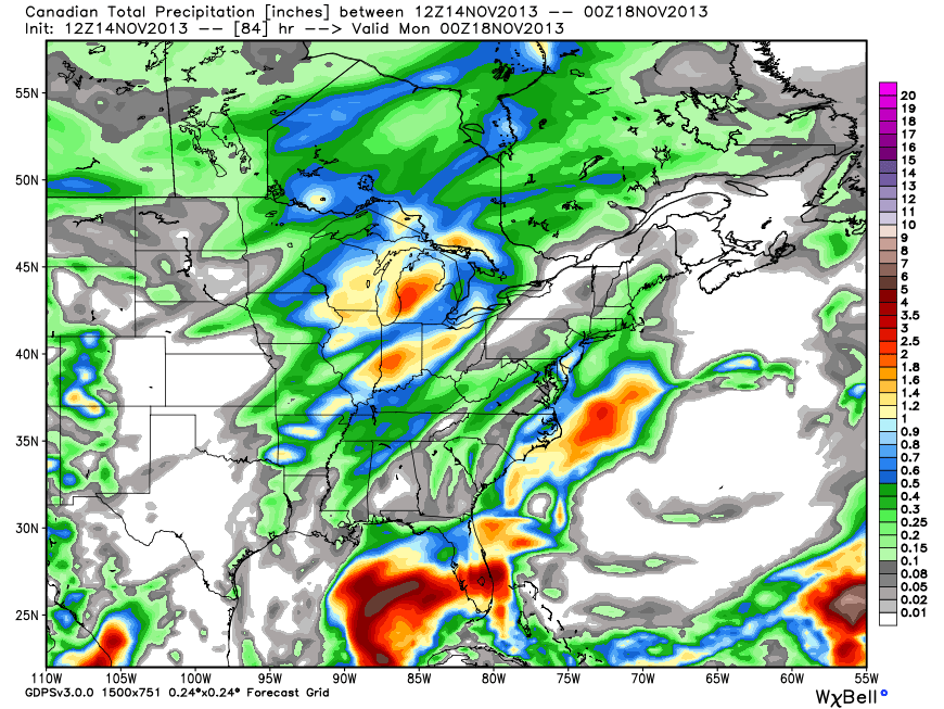
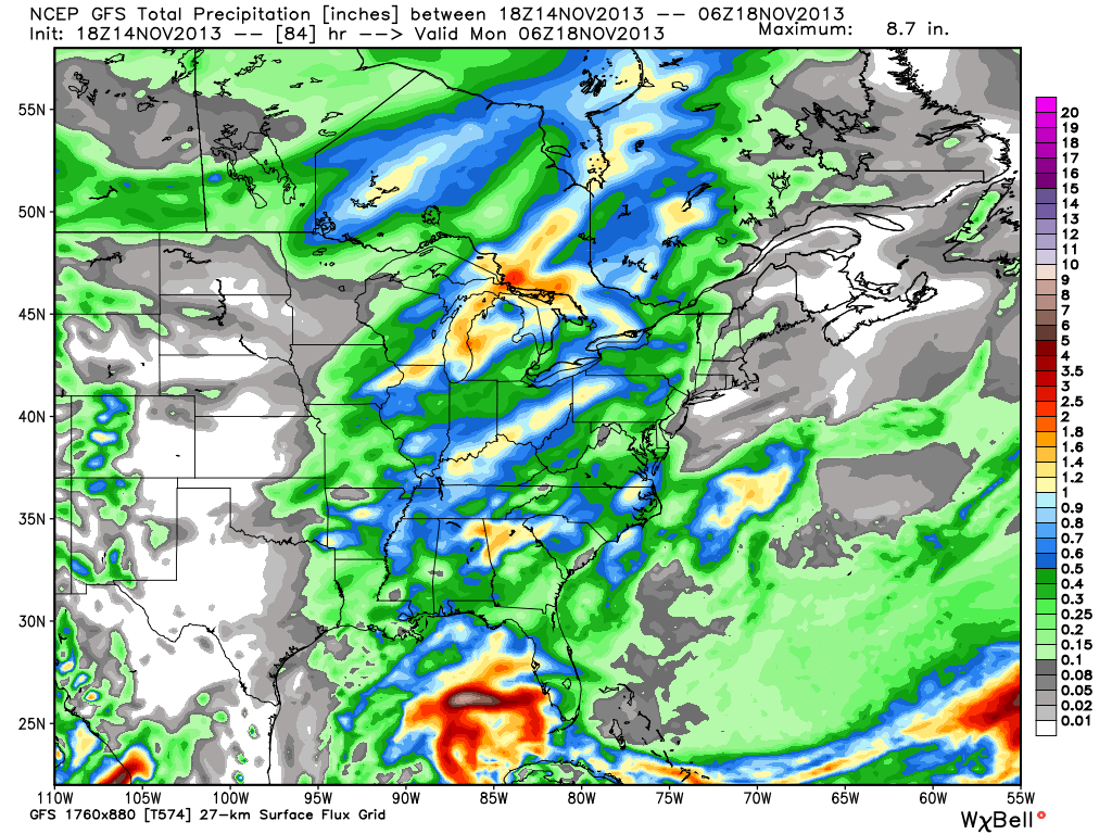
Sunday: Cloudy with rain likely (0.45″); 52/ 60

More widespread rain will arrive for the second half of your weekend.  Highs will approach 60 and should we see any sunshine (not looking likely at this point), temperatures could go into the lower to middle 60s. While temperatures will be much warmer we’ll have to contend with rain Sunday.

Status-weather-storm-night-icon
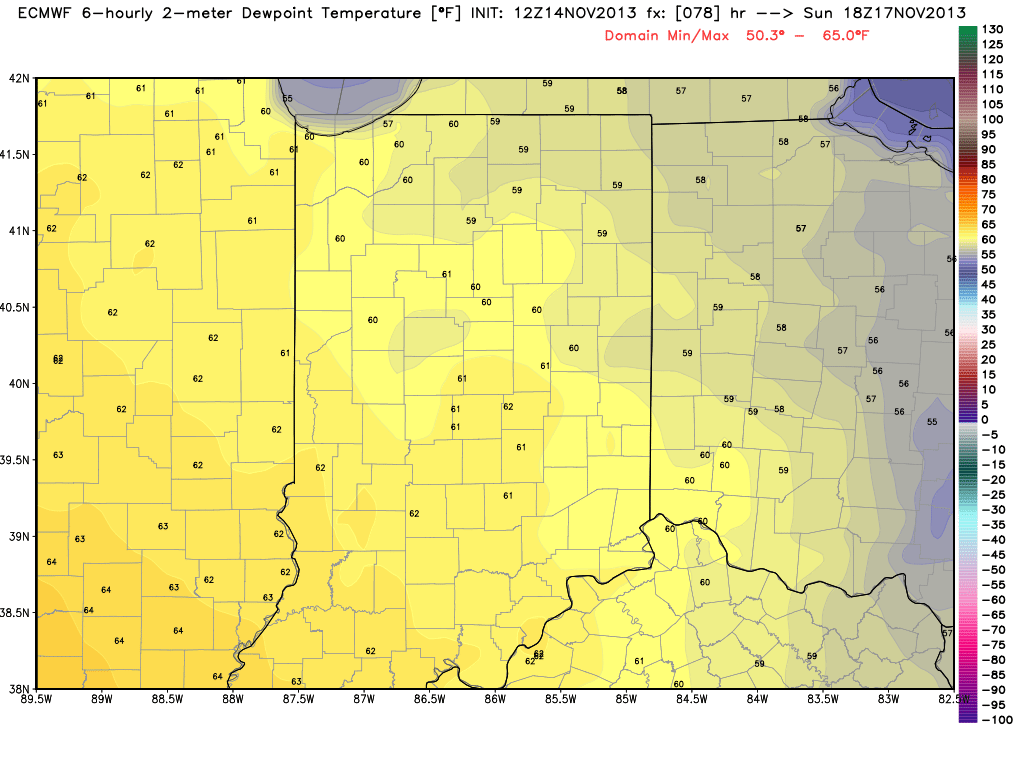
Monday: Showers and possibly a thunderstorm (0.50); 34/ 63

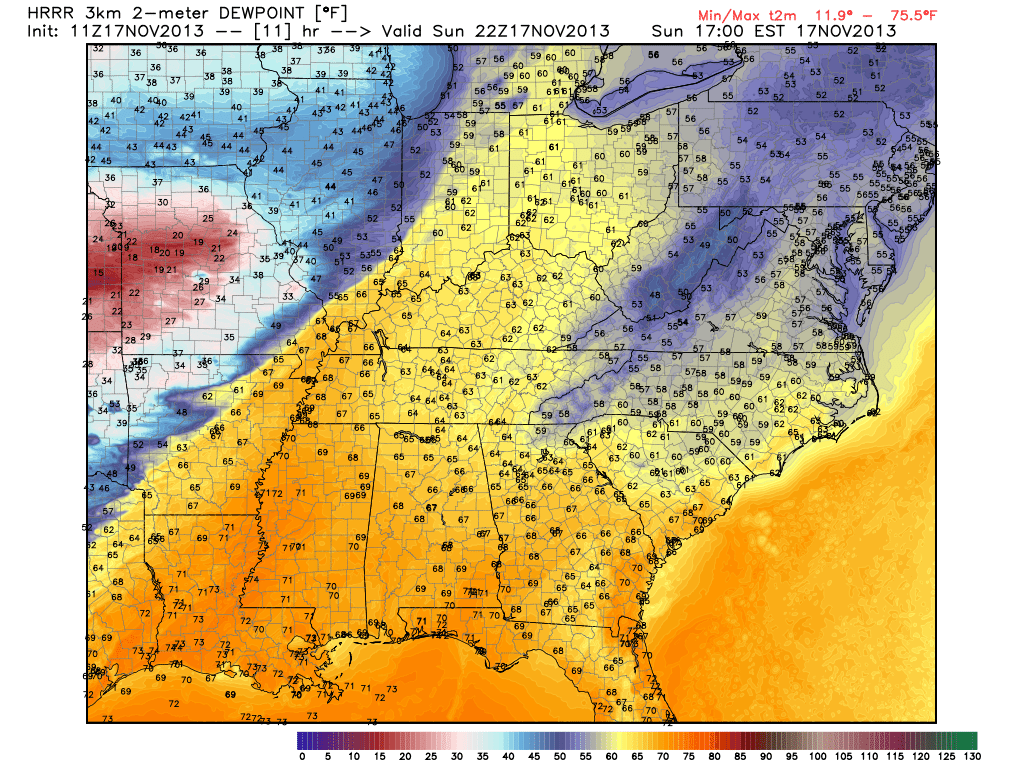
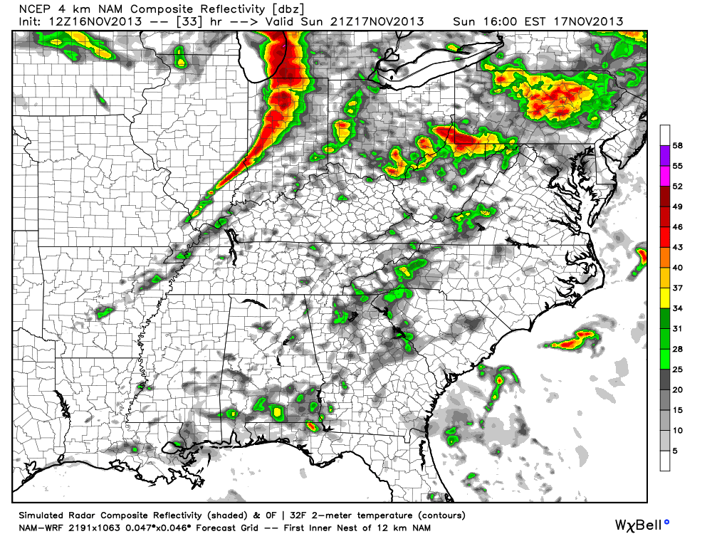
A strong cold front will blow through the state Monday evening. Out ahead of the front, an impressive surge of warmer and more humid air will move north and encompass central Indiana during the day. In fact, latest model data suggests dew points reach the lower 60s Monday. The combination between the warmer, more humid air in place and an impressive surge of arctic air behind the front could team up to produce a clap or two of thunder with the moderate to heavy rain threat Monday afternoon as the front moves through. Temperatures will then crash Monday night.

Status-weather-snow-scattered-day-iconTuesday: Scattered snow flurries; 24/ 34

The big story Tuesday will be the much colder air mass rushing into the state on strong and gusty northwest winds. Just enough moisture may linger to create the chance of scattered snow flurries.
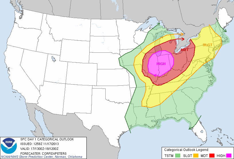
Permanent link to this article: https://indywx.com/wednesday-forecast-a-bitterly-cold-start/