Category: Autumn

Showers Today; Drier, Cooler Theme The Rest Of The Week…

Wed.

Thr.

Fri.

Sat.

Sun.

Mon.

Tue.

 Status-weather-showers-scattered-icon

 Status-weather-clouds-icon

 Status-weather-clouds-icon

 Status-weather-clouds-icon

 Status-weather-clouds-icon

 Status-weather-showers-day-icon

 Status-weather-showers-day-icon

52/ 57

51/ 62

49/ 67

42/ 53

38/ 53

41/ 59

44/ 57 

Showery Wednesday…A big ole swirl continues across our region, courtesy of an upper level low moving slowly east through the Ohio Valley.  This will help generate light to moderate showers today, focused on this afternoon and evening for most widespread activity.  Otherwise, expect a chilly day as highs don’t make it out of the 50s.

Increasing Sunshine, But Cooler…Though it’ll be slow to take place at first, increasing sunshine can be expected as we put a wrap on the work week.  Thursday will likely still feature considerable cloudiness, but just the chance of an isolated shower (most stay dry Thursday).

The story for the weekend will be one that features dry, yet chilly fall weather.  Below normal temperatures and mostly sunny to partly cloudy conditions can be expected.

Fast Moving Early Week System…A fast moving frontal boundary will race through the area Monday evening into early Tuesday with another chance of light to moderate rainfall.

Upcoming 7-Day Precipitation Forecast:

  • 7-Day Rainfall Forecast: 0.25″ – 0.50″
  • 7-Day Snowfall Forecast: 0.00″

Does your business depend on snow removal or the impact on winter weather?  Email us at bill@indywx.com for more information on fully customizable winter weather consulting.

Permanent link to this article: https://indywx.com/showers-today-drier-cooler-theme-the-rest-of-the-week/

Much Needed Dry Time On Deck For #Harvest14…

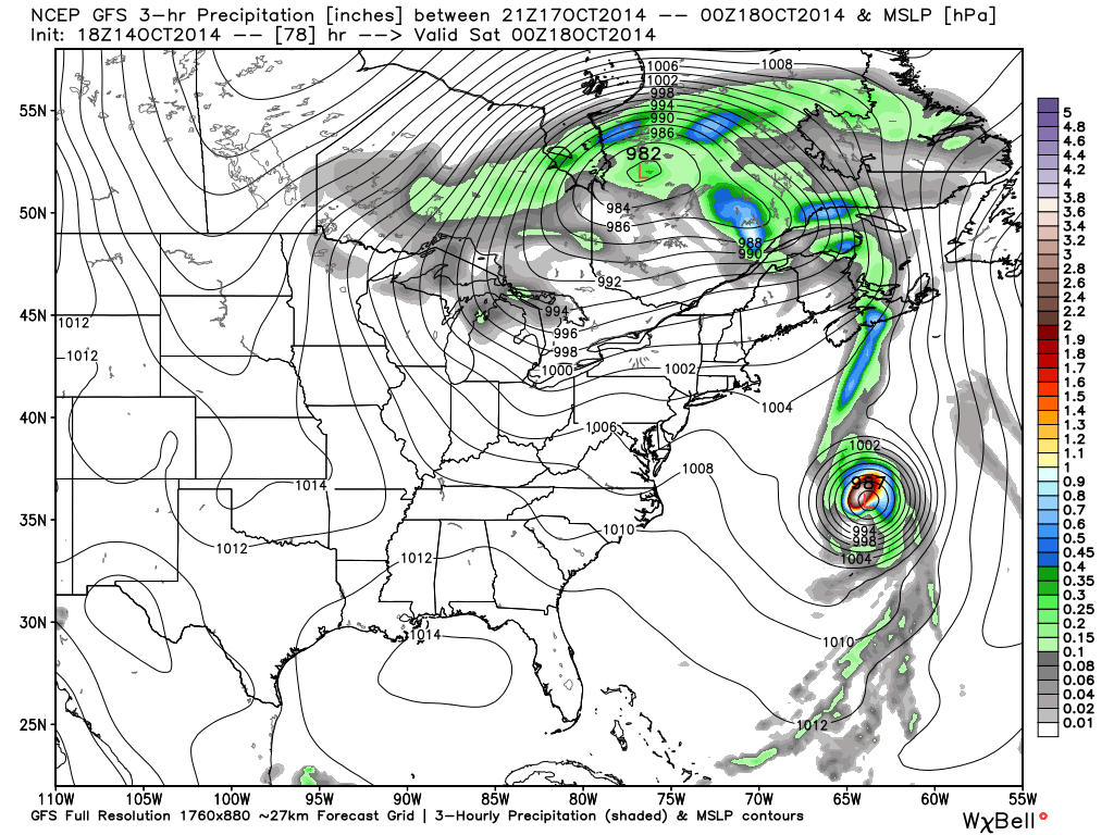
Despite another day of showery, damp weather Wednesday, the overall “trend is our friend” in the short to mid range as a much drier pattern develops.

Drier, cooler air will penetrate into the Mid West and Ohio Valley as the weekend draws closer.

gfs_precip_mslp_east_19


gfs_precip_mslp_east_27


gfs_precip_mslp_east_43


It’s important to note the GFS has support on the drier trend to include some other highly respected mid range model suites such as the Canadian and European.

The next round of rain arrives Tuesday with reinforcing chilly air that could deliver mid and late week frost and freeze conditions for parts of the region.  The Canadian is a little more bullish on rainfall totals when stacked against the GFS and European.  We’ll continue to monitor.

gfs_precip_mslp_east_51


cmc_precip_mslp_east_26


Regardless of Tuesday rain, we’ll quickly return to a dry regime by the middle of next week.

The Climate Prediction Center (CPC) agrees on a drier pattern in the mid range.

814prcp.new


Latest forecast rainfall totals off the GFS model suggest amounts of 0.50″, or less, across the region over the upcoming 7-days, and it’s important to note half of that likely falls Wednesday with showers associated with swirling low pressure around the region.

gfs_total_precip_east_30


Note the cooler trend developing in the 7-day, as well:

KIND_2014101418_tx_192

If your company depends on snow removal or other types of winter weather, please send us an e-mail for customized winter weather consulting at bill@indywx.com.

Permanent link to this article: https://indywx.com/much-needed-dry-time-on-deck-for-harvest14/

Tuesday Morning Rambles: Rain, Dry Time, And Frost?!

More rain is in the forecast today and Wednesday as a big, slow moving autumn storm system takes its time moving through the region. Additional rain the next 36 hours…

You must be logged in to view this content. Click Here to become a member of IndyWX.com for full access.  Already a member of IndyWx.com All-Access?  Log-in here.

Permanent link to this article: https://indywx.com/tuesday-morning-rambles-rain-dry-time-and-frost/

Cool Autumn Weekend; Severe Storm Potential Monday Night…

Sat.

Sun.

Mon.

Tue.

Wed.

Thr.

Fri.

 Status-weather-clouds-icon

 Status-weather-showers-day-icon

 Status-weather-storm-night-icon

 Status-weather-showers-scattered-icon

 Status-weather-clouds-icon

 Status-weather-clouds-icon

 Status-weather-clouds-icon

– –/ 59

42/ 62

56/ 73

55/ 67

52/ 63

51/ 60

50/ 69 

Cool Autumn Weekend…The rest of today will feature mid and high level cloudiness, but dry conditions.  Cool north to northeast winds will blow and require jackets or sweaters if venturing outside for too long of a time.

Be sure to enjoy the brief dry weather Saturday as shower chances return as early as Sunday, particularly during the afternoon hours and on.  Moisture will begin to surge back north in advance of a storm system that will lead to some rough weather around these parts to open the new work week.

Monday Severe Potential…Gusty southwest winds will usher in a warmer and more humid feel of things Monday out ahead of our next strong storm system.  We continue to closely monitor the potential of severe weather Monday night into Tuesday morning and want to highlight the threat of damaging straight line wind potential embedded with a possible squall line.  Beforehand, showers and embedded thunder will be possible during the daytime Monday.

We note the GFS remains consistent on strong to severe storm potential Monday night into Tuesday morning while the European is more delayed (suggesting more of a threat during the day time Tuesday).  For now, we’re leaning more towards the GFS and we’ll have more on the early week severe threat Sunday.  Locally heavy rain is also a good bet during this time, including widespread 1″-1.5″, with locally heavier totals.

Taking The More Optimistic Approach…Some forecast data wants to keep considerable cloudiness and pesky light showers around into the mid week period, but for now we’re still going with the more optimistic outlook and including drier weather along with cooler temperatures for the balance of the upcoming work week.

Upcoming 7-Day Precipitation Forecast:

  • 7-Day Rainfall Forecast: 1-2″
  • 7-Day Snowfall Forecast: 0.00″
hires_ref_ky_61

We continue to highlight Monday night/ Tuesday morning for the potential of severe weather, including damaging straight line winds. Here’s what the high resolution NAM simulated radar suggests at 8p Monday local time.


Permanent link to this article: https://indywx.com/cool-autumn-weekend-severe-storm-potential-monday-night/

IndySportsReport.com High School Football Forecast: Rain For Some…

A stalled frontal boundary is draped over central portions of the state this morning and an area of low pressure will move east along the front today. High pressure to…

You must be logged in to view this content. Click Here to become a member of IndyWX.com for full access.  Already a member of IndyWx.com All-Access?  Log-in here.

Permanent link to this article: https://indywx.com/indysportsreport-com-high-school-football-forecast-rain-for-some/