VIDEO: Windy & Unseasonably Cool Close To The Work Week…
You must be logged in to view this content. Click Here to become a member of IndyWX.com for full access. Already a member of IndyWx.com All-Access? Log-in here.
You must be logged in to view this content. Click Here to become a member of IndyWX.com for full access. Already a member of IndyWx.com All-Access? Log-in here.
 Highlights:
Calm Before The Storm…Weak high pressure will control our midweek weather. Patchy fog will eventually burn off to partly cloudy conditions this afternoon. A backdoor cold front will, uneventfully, slip through the state Thursday. An isolated shower or thunderstorm is possible Thursday afternoon, but most neighborhoods should remain rain-free.
Then our attention turns to Harvey’s remnants. The greatest impact on central Indiana will be unseasonably cool temperatures and strong and gusty easterly winds. While the precipitation shield should encompass all of central Indiana, we still believe this will be more “showery” in nature for the city and points north, including north-central parts of the state. Steadier and heavier rains are likely across southern and southeastern portions of the state (where the axis of 2″+ totals will be likely). The combination of high pressure located to our northeast and Harvey’s circulation passing along the Ohio River will result in a very stiff easterly flow Friday. Expect temperatures in the 50s most of the day with gusts over 30 MPH at times. Have the jackets and sweaters ready.
Moisture will begin to pull east of the region Saturday, but we’ll include the chance of morning showers.
We’ll be in between storms Sunday and Labor Day, itself. Dry and pleasant conditions can be expected before a strong cold front moves through the state Tuesday. Scattered showers and a possible thunderstorm will accompany this frontal passage, followed by the coolest air since last spring by the middle of next week. Get set for an October-like feel…
Upcoming 7-Day Precipitation Forecast:
I.) Overnight rain and storms impacted central Indiana during the overnight. Some of the slow moving storms dumped a quick 2″ of rain in isolated areas, but most ended up…
You must be logged in to view this content. Click Here to become a member of IndyWX.com for full access. Already a member of IndyWx.com All-Access? Log-in here.
 Highlights:
Dry Close To The Weekend…First and foremost, our thoughts and prayers are with Texas as one of the worst flood events in our country’s history is unfolding this morning. With days of heavy rain ahead, an additonal 20″-30″ will fall on eastern Texas. Just horrific.
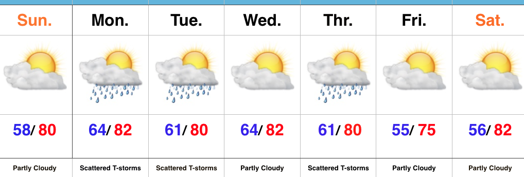
Here on the home front, we’ll wrap up the weekend on a dry note, but upper level energy will drift overhead late tonight and help generate scattered showers and thunderstorms as early as the predawn hours Monday. We’ll maintain a bit of an unsettled regime into Tuesday before dry conditions return Wednesday.
A backdoor cold front will push through central Indiana Thursday and a broken line of showers and thunderstorms may accompany this frontal passage. A northeasterly flow will usher in an unseasonably cool, early fall-like, close to the work week.
Looking ahead, an even stronger cold front has it’s eyes set on the region late next weekend or early the following week. Strong thunderstorm potential is present with this storm system followed by the coolest air since last spring…
Upcoming 7-Day Precipitation Forecast:
Good morning, friends! Temperatures this morning are in the lower 50s for many across central Indiana as our “hint” of fall continues to wrap up the month of August. I…
You must be logged in to view this content. Click Here to become a member of IndyWX.com for full access. Already a member of IndyWx.com All-Access? Log-in here.