Category: Autumn

Sunday Morning Notebook; Active Pattern Remains…

For a change, the past (7) days has been generous to central Indiana from a precipitation perspective.  As we’ll discuss, a new rain maker awaits this week.
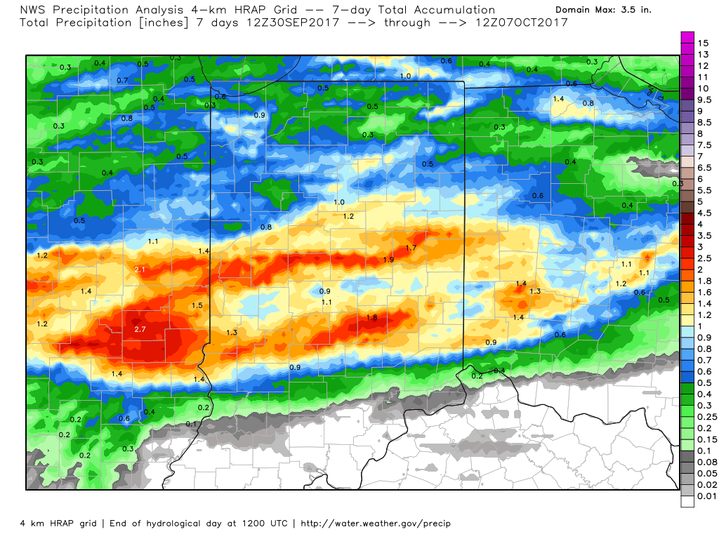
A look at rainfall totals over the past 7 days, courtesy of weatherbell.com.

Officially, IND sits at 0.26″ above normal, month-to-date.

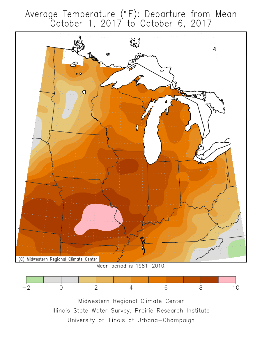
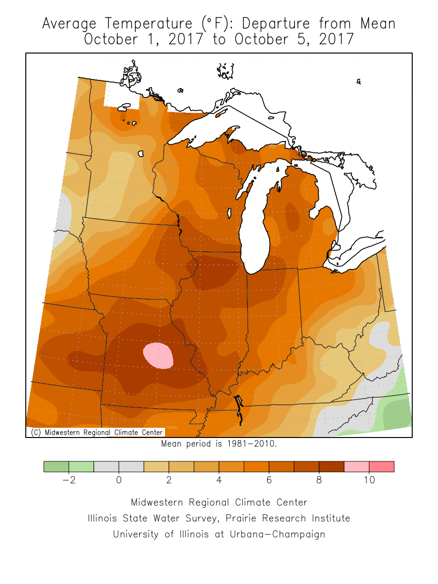
It’s also been an incredibly warm start to the month (IND is running 10° above normal, month-to-date) and that warm theme won’t change through the near-term.
An all-too-familiar pattern engulfs the country late week.  This will showcase more “bonus” summer-like conditions, locally, that will include highs approaching 80° next weekend with a strong southerly flow in place.  Additionally, early winter-like conditions will continue to impact the western high ground.  The pattern definitely represents a Nina look.
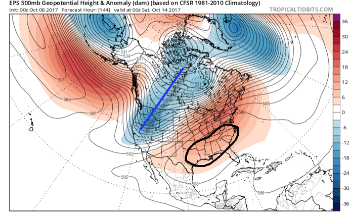
The southeast ridge will provide more bonus summer-like conditions next weekend across the eastern half of the country.

In the shorter-term, a new rainmaker will move across the Ohio Valley Tuesday into Wednesday.  This will spread showers and embedded thunder across the state Tuesday PM into Wednesday.  In general, this storm system should deliver 0.50″ – 1″ of rain, but there will be locally heavier amounts.
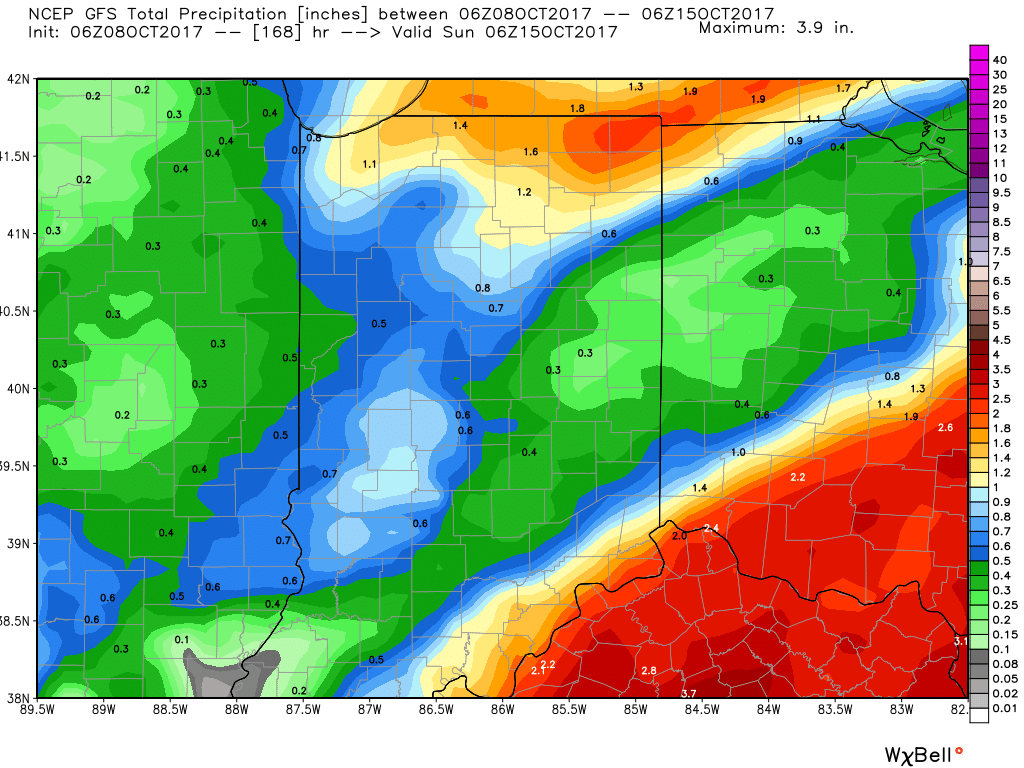
Thereafter, dry times will settle in along with slightly cooler temperatures.  Let’s remember it was only a few days ago where modeling suggested a “pop” of the season’s coldest air thus far.  No longer is that the case, and while it will turn briefly cooler, temperatures will still remain above average.

A southerly air flow will return late week and help boost temperatures next weekend, along with continued dry times through the balance of the weekend.  From this distance, our next storm system should arrive late Sunday or early Monday in the form of a cold front.

Looking longer-term, there are indications that colder conditions loom as we wrap up October and head into November and we’ll discuss this in more detail later this week…

Permanent link to this article: https://indywx.com/sunday-morning-notebook-active-pattern-remains/

Warm Saturday; Storms Rumble In Late…

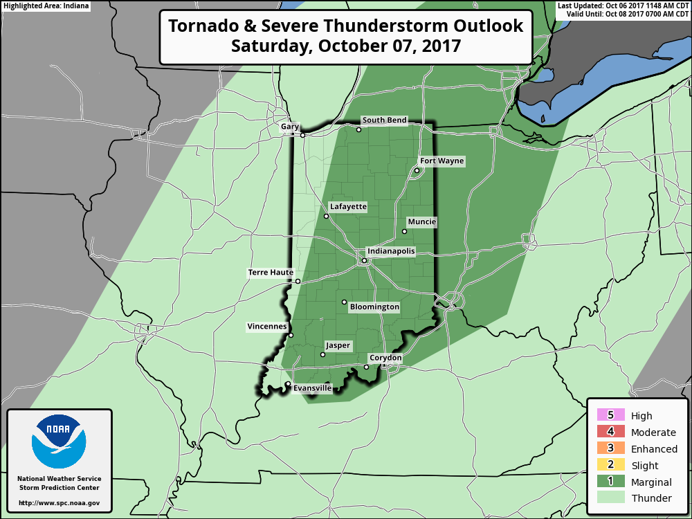
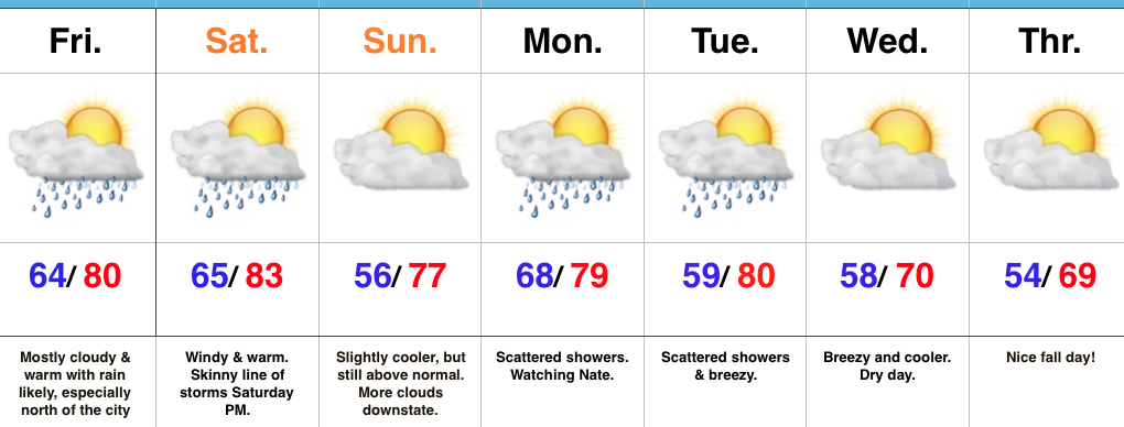
October has gotten off to a warm start (+ 8.4° at IND, to be exact) and that will continue this weekend as high temperatures top out between 80° – 85° Saturday.

October has gotten off to a warm start across the Mid West.

In addition to Saturday’s warmth, southwest winds will gust over 35 MPH at times- especially during the afternoon hours.

Most of Saturday will remain rain free, but we’ll need to keep an eye towards the western horizon Saturday afternoon as a frontal boundary helps kick up a line of thunderstorms.

The Storm Prediction Center (SPC) includes a large portion of Indiana under a marginal risk of severe weather Saturday.  While widespread severe weather isn’t anticipated, a couple of embedded gusty storms are a good bet Saturday afternoon and evening.

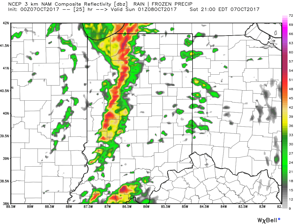
The biggest concern with stronger storms is gusty straight line winds.  While the line of storms should be relatively “skinny,” don’t be surprised if one or two of the storms requires a warning.  Here’s an idea of what the radar may look like around 9p Saturday.
We’ll turn less humid and slightly cooler for the second half of the weekend!
Permanent link to this article: https://indywx.com/warm-saturday-storms-rumble-in-late/

More Rain For Some; Watching Nate…

Highlights:

  • Wet close to the work week for some
  • Saturday storms
  • Watching Nate

Unsettled Close To The Work Week…Thursday’s weather was just what the doctor ordered!  Officially, here at IndyWx HQ, we recorded 0.73″.  Many neighborhoods throughout central IN accumulated more than 1″ of much needed rainfall!  Thankfully, additional rain chances are present as we wrap up the work week.  Most widespread showers and embedded thunder will impact the northern half of the state Friday, especially the northern third of the state.

As we flip the page over to the weekend, mostly dry conditions can be expected, with the exception of a skinny line of thunderstorms that will blow through the state Saturday evening.  These will come and go rather quickly and we’ll get into a slightly cooler and drier regime to wrap up the weekend.

Attention this weekend will be what comes of Nate.  Overall, ideas haven’t changed over the past 24 hours, including an eventual late weekend landfall along the north-central Gulf Coast.  That said, precise all-important details concerning overall strength are still debatable.  Interests along the north-central Gulf Coast should monitor updates closely.  Here on the home front, we note subtle differences between the GFS and European in regards to inland impacts.  For now, we’ll go with a blend between the two, thinking most of the more significant, steady rains remain southeast of central Indiana.

Eventually a cold front will sweep through the state Tuesday night.  This will result in a NW wind shift and cooler air spilling in here later next week.

Upcoming 7-Day Precipitation Forecast:

  • Snowfall: 0.00″
  • Rainfall: 0.25″ – 0.75″

Permanent link to this article: https://indywx.com/more-rain-for-some-watching-nate/

VIDEO: Soaking Rains, Tropics, And A Much Cooler Feel Next Week…

You must be logged in to view this content. Click Here to become a member of IndyWX.com for full access.  Already a member of IndyWx.com All-Access?  Log-in here.

Permanent link to this article: https://indywx.com/video-soaking-rains-tropics-and-a-much-cooler-feel-next-week/

Bonus Summertime…

Highlights:

  • Scattered shower and t-storm chances return
  • Warm pattern continues
  • Changes loom later next week

Enjoy The Warmth While We Have It…A frontal boundary will “meander” around the Ohio Valley over the next couple of days.  It’ll sink south as we close the work week before lifting back north as a warm front this weekend.  At the same time, surface low pressure will track from the Plains into the Great Lakes this weekend.  The end result will be more unsettled conditions returning to the region after our extended dry spell.  It certainly won’t rain the entire time (in fact, most of the forecast period will be rain-free), but plan for scattered to numerous showers and thunderstorms at times beginning as early as Wednesday.  Additionally, as the front sags south Friday, slightly cooler air will work into central Indiana before a warmer southerly air flow takes over once again this weekend.

As we flip the page to next week, a couple of frontal boundaries will push southeast.  Additionally, the “wild card” in this forecast is what may eventually become of an area of disturbed weather in the Gulf of Mexico.  While modeling differs on the evolution of things, a couple of solutions bring this into the north-central Gulf Coast this weekend before moving north and delivering widespread rain inland.  It’s far too early for specifics, but we’ll keep a close eye on things.

Back to the FROPA discussion:  The initial front won’t have much impact on area temperatures (still well above normal), but will be enough to include widely scattered storm chances early next week.  The second frontal passage will lead to a MUCH cooler feel just beyond the current 7-day period.  In fact, the air will grow chilly enough in the 8-10 day timeframe where it’ll actually feel more like November, and the first frost of the season may await for most of central Indiana…

Upcoming 7-Day Precipitation Forecast:

  • Snowfall: 0.00″
  • Rainfall: 0.50″ – 1.00″

Permanent link to this article: https://indywx.com/bonus-summertime/