Category: Auburn

Checking In On Those Test Cases…

Updated 08.27.22 @ 7:53a

First and foremost, happy college football season! Sure, this weekend’s games aren’t terribly exciting, but LIVE college football is back and sets the stage for an incredible slate this upcoming weekend! I’m looking forward to being on the Plains of southern Alabama next weekend to celebrate the return of another special Auburn football season!

I will still be posting a Client Video later today, but wanted to dedicate this post to the two test cases in the week ahead:

I. Strength and magnitude of the cooler air to open September

II. Pre Labor Day tropical excitement in the Gulf of Mexico

Let’s start with the cooler potential. The European has trended closer to the GFS solution in recent runs, opening September on a cooler than normal note. The GFS is still more aggressive with the cool down to open up meteorological fall, but the European is trending more and more towards this solution. What’s at stake? A couple of days to open the month with lows into the lower 50s (mid to upper 50s inside the circle, itself) and highs in the upper 70s with that classic autumn sky. Side note: a significantly warmer (hotter) pattern looms thereafter.

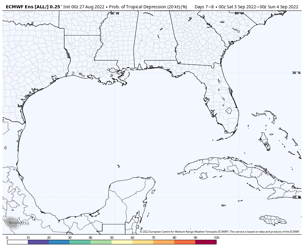
Now let’s talk about the tropics. Not much has changed here with the vast differences in handling the lead feature (threat in the Gulf of Mexico as Labor Day weekend nears). This morning, the GFS continues to beat the drum on this potential while the European isn’t excited in the least. We note the European ensemble product isn’t even hinting at the threat of a depression to develop during this period. It’ll be mighty interesting to see how this plays out in the coming days. We should gain more clarity early in the work week. I will say, should something form, it appears to be an eventual southern of western Gulf threat from this distance.

GFS remains bullish on a tropical threat in the Gulf Labor Day weekend.
Meanwhile, the European is having none of it…

Video discussion looking over 12z data and jumping ahead to the next big surge of warmth will be online later today.

Permanent link to this article: https://indywx.com/checking-in-on-those-test-cases/

Long Range Rambles On Iron Bowl Saturday…

Updated 11.27.21 @ 5:56a

The theme of the better part of the autumn season has been a story of contradicting signals- teleconnections and MJO alike. When we look ahead to the beginning of meteorological winter (Dec. 1st), it sure appears that will continue to be the story. For a brief moment the East Pacific Oscillation (EPO) tries to go negative. This is interesting in and of itself as only a couple days ago the EPO was forecast positive during this period.

Meanwhile, the PNA is forecast negative to open the month.

The “wildcard” in this entire December outcome has to do with the MJO. If (still a big if) we can get things to amplify, then a whip around the historically December cold phases (7, 8, and 1) appear in order.

If the MJO doesn’t get in the game, the pattern, at best, will be one of continued transition (colder and warmer than normal periods) and that’s what the majority of ensemble guidance currently shows. Without a favorable MJO, it’s tough to see how meaningful, more sustained arctic air can get into the mix, locally.

As far as storm systems of note, we’re in an incredibly quiet period and that looks to continue through the upcoming 5-6 days. We’ll keep eyes to our north where weak systems will zip by in the fast flow aloft, but most, if not all, of these should remain to our north and east. It’s not until early next weekend (looks like Friday or early Saturday as of now) when our next system of more significance is slated to impact the area.

War Eagle and happy Iron Bowl Saturday! 😀

Permanent link to this article: https://indywx.com/long-range-rambles-on-iron-bowl-saturday/

Those Special College Football Saturdays Return: Rolling Into A More Fall-Like Weather Pattern…

Updated: 09.18.21 @ 1a

You must be logged in to view this content. Click Here to become a member of IndyWX.com for full access.  Already a member of IndyWx.com All-Access?  Log-in here.

Permanent link to this article: https://indywx.com/those-special-college-football-saturdays-return-rolling-into-a-more-fall-like-weather-pattern/

VIDEO: Tracking A Line Of Storms This Evening And Potential Of A Stronger Cold Front Early Next Week…

Updated 09.14.21 @ 7:50a

You must be logged in to view this content. Click Here to become a member of IndyWX.com for full access.  Already a member of IndyWx.com All-Access?  Log-in here.

Permanent link to this article: https://indywx.com/video-tracking-a-line-of-storms-this-evening-and-potential-of-a-stronger-cold-front-early-next-week/

Periods Of Heavy Rain & Strong-Severe Storms To Open The Work Week…

An unsettled open to the work week is upon us. Periods of showers and thunderstorms can be expected this morning through Wednesday morning.  Tuesday will present the most widespread thunderstorms and a few of these could reach strong-to-severe levels.  Locally heavy rain can be expected at times.  The greatest concerns from a severe perspective center around large hail and damaging straight line winds, but a couple of tornadoes can’t be ruled out.

Most widespread coverage of storms will arrive Tuesday.

Heaviest rain amounts will fall across eastern parts of the state where widespread 1″ to 2″ with locally higher amounts are expected by Wednesday morning.  With that said, localized 1″+ amounts will also fall across northwest parts of the state as shown on the latest high resolution NAM.

The frontal boundary will sweep through the state late Tuesday and allow a cooler and drier air mass to filter into the region Wednesday.  You’ll notice a true fall feel out the door Wednesday morning- low to mid 50s.  Highs Wednesday afternoon will remain in the 60s.

Permanent link to this article: https://indywx.com/periods-of-heavy-rain-strong-severe-storms-to-open-the-work-week/