Category: Arctic Cold

Blocking Matures And Forces “Chaos” Underneath…

Before we touch on the post-Christmas period, I wanted to provide a quick update on the pre-Christmas arctic front. In short, we have no changes to our ongoing thoughts concerning this system.

The arctic front is still expected to arrive Wednesday night with showers that end as a “touch” of snow.

MUCH colder and windy conditions can be expected Christmas Eve with upper level energy teaming up with the pressing arctic airmass to help generate backlash snow showers and embedded squalls. These may deposit a dusting to less than 1″ for some, but others likely won’t see any accumulation. Winds will absolutely howl and combine with the falling temperatures to create bitter wind chill values Christmas Eve night into Christmas Day. We still anticipate wind chill values to fall into the 0° to 10° below zero range.

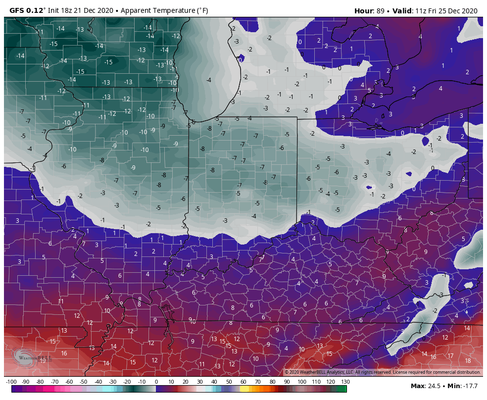
Highs Christmas Day will only top out in the lower 20s.

Then our attention will shift to the period Dec. 27th through Jan. 7th. During this time frame, I’m expecting at least a couple of storm systems to put us on the playing field for more meaningful wintry conditions.

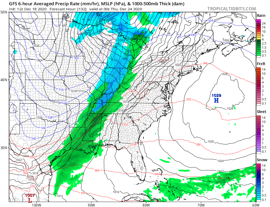
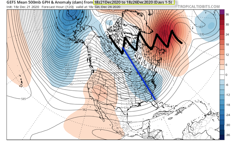
The teleconnections will finally align in a manner more conducive for interior and east coast wintry weather (remember, we’ve been “fighting” that positive EPO as of late). A byproduct of the negative AO and NAO is high latitude blocking. Unlike our Christmas storm (photo 1 below), the blocking matures in significant fashion during the aforementioned period and should force a more favorable storm track (photo 2 below).

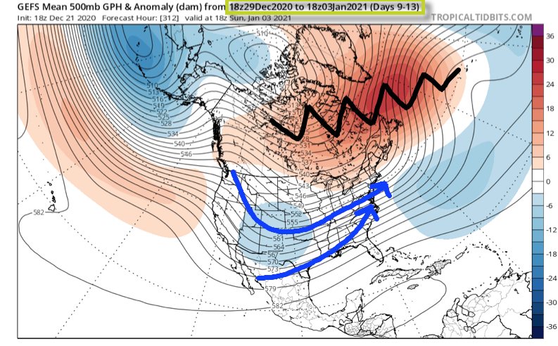
Once to the medium to long range (Days 9-13), the once progressive pattern is no more. Instead, we should see much slower moving storm systems that try and cut into the Ohio Valley only to be forced south. This is the type pattern that can lead to a couple of back-to-back winter weather makers of various significance, including a wintry mix of precipitation across the greater OHV region- especially if only marginally cold air is available. The other item to keep an eye on is the likely trend that develops with the operational data over time. Don’t be surprised to suddenly see guidance trend south with the ‘mean’ storm track during the 12/27 through 1/7 time period as we get closer to real time. This is all a byproduct of the blockiness. Should we get into a situation where we have a couple of winter events lay down accumulating ice and snow then don’t be surprised if the data trends away from the “seasonal” look right now towards one colder as time draws closer.

As it is, this is still a pattern that looks more active/ stormy as opposed to overly cold. With that said, as much as we were against the idea of a big pre-Christmas storm, locally, we remain as bullish as ever on the last few days of December and to open January feeding those hungry for winter weather.

Stay tuned…

Permanent link to this article: https://indywx.com/blocking-matures-and-forces-chaos-underneath/

VIDEO: Cold Christmas And Reasons Why We’re Bullish On A Stormy Lead Up To New Years…

You must be logged in to view this content. Click Here to become a member of IndyWX.com for full access.  Already a member of IndyWx.com All-Access?  Log-in here.

Permanent link to this article: https://indywx.com/video-cold-christmas-and-reasons-why-were-bullish-on-a-stormy-lead-up-to-new-years/

VIDEO: Very Cold Christmas; Plenty Of Mischief Ahead To Close December And Open Jan…

An arctic cold front will blow through here Wednesday night allowing bitterly cold air to arrive just in time for the Christmas holiday. More on this and a look ahead…

You must be logged in to view this content. Click Here to become a member of IndyWX.com for full access.  Already a member of IndyWx.com All-Access?  Log-in here.

Permanent link to this article: https://indywx.com/video-very-cold-christmas-plenty-of-mischief-ahead-to-close-december-and-open-jan/

VIDEO: Cold Christmas Dialed Up; Active Pattern Remains To Open 2021…

A shot of arctic air awaits for Christmas and we look ahead to a pattern that should continue to promote fun and active times as we put a wrap on…

You must be logged in to view this content. Click Here to become a member of IndyWX.com for full access.  Already a member of IndyWx.com All-Access?  Log-in here.

Permanent link to this article: https://indywx.com/video-cold-christmas-dialed-up-active-pattern-remains-to-open-2021/

A Friday Evening Note On The Christmas Eve Arctic Front…

You’d be hard pressed to find one single day where there’s more interest and speculation on the weather than Christmas Day. Many (self included) dream of scenes like this every Christmas:

An arctic front will put many in the game (including deep into the South) for the opportunity of snow (or Christmas Eve snow) on the big day, itself. As energy rounds the base of a deepening trough, a wave of low pressure will develop along the pressing arctic boundary.

We expect the front to blow through our neck of the woods late Wednesday night and early Christmas Eve morning. A period of precipitation will likely accompany the front. We expect rain to develop Wednesday night before mixing with and changing to snow early Christmas Eve morning.

Heavier snow is anticipated across the interior portion of the Northeast down the spine of the Appalachians Christmas Eve into Christmas Day as the wave of low pressure becomes better organized. The pattern is simply too progressive to allow for a big event this far west.

Trailing upper level energy could spark scattered snow showers back this way, but we believe between the 2 opportunities for that magical Christmas snow, only minimal accumulations can be expected here across central Indiana (“ridiculously” early call is for a dusting to perhaps 2″ type event). Further northeast, lake effect snow will likely add up to several inches across the northeastern IN snow belts.

Bitterly cold, arctic, air will pour into the region Christmas Eve and Christmas Day along with gusty northwesterly winds. We still anticipate below zero wind chill values (0° to – 10° Christmas morning).

A blocky pattern looks to remain in place as we close the year and open up 2021. As such, active times will continue for the foreseeable future…

Permanent link to this article: https://indywx.com/a-friday-evening-note-on-the-christmas-eve-arctic-front/