Category: Arctic Cold

Potential Is Mighty, But Can It Turn To Reality?

Updated 12.31.23 @ 4:13p

We’re heading towards a “special” pattern over the next couple weeks, especially for winter weather enthusiasts. The potential in the said pattern is mighty, but can potential become reality? Thankfully, we have a quiet open to the month to track all of the possibilities that begin to take their position this upcoming weekend.

It’s easy to become enamored with the expansive trough and coast to coast cold that follows in the 10-15 day range (by the way, truly bitter air should arrive during this period), but what’s more interesting to me is the building Greenland Block. That kind of block usually promotes all sorts of wintry “fun and games” here and across a large chunk of the country. It’s also note worthy as it tends to lead to more sustainable wintry conditions. Perhaps the “extreme and nothing in between” cold solution/ lean for the latter part of January may have merit?

While far too early for specific details, the stormy shift appears to be a good call with the initial storm taking aim on the region this upcoming weekend, followed by a second system that also has the potential of producing wintry weather the early and middle part of the following week. Simply put, the threat of winter storm(s) is growing over the course of the upcoming 10 days.

Details to follow in the week ahead!

Permanent link to this article: https://indywx.com/potential-is-mighty-but-can-it-turn-to-reality/

Thoughts On The First Couple Weeks Of The Year (And Beyond)…

Updated 12.31.23 @ 8:40a

The MJO is rolling right into the notorious cold (for this time of year) phase 3 as we open up the new year.

The composite analog for phase 3 in January from an upper air and surface temperature anomaly standpoint:

Ensemble guidance shows the widespread colder than normal temperatures overspreading the country. Like clockwork, this is almost identical to the Phase 3 analog above.

After a quiet week, we’ll watch 2 storms in the 5-10 day period. The first comes along next weekend. While still far too early to get detailed, this one does have potential to serve up some wintry mischief to the Ohio Valley, including central Indiana.

The second storm follows and it’s behind this feature that more of a truly arctic air mass will get involved in our pattern.

The pattern will stay busy as the arctic air presses in. At the same time, note the Greenland block beginning to form. Winter weather enthusiasts have to be chomping at the bit by that 10-15 day look. Needless to say, we can expect a rapidly expanding snow pack across the Lower 48 over the next couple weeks.

Thereafter, all eyes will remain on the MJO. Do we roll into the “null phase,” such as what the European suggests or swing through the traditionally mild/ warm phases such as the American guidance portrays? Stay tuned…

Permanent link to this article: https://indywx.com/thoughts-on-the-first-couple-weeks-of-the-year-and-beyond/

A Tale Of 2 Potential Extremes For Late January And An Early Lean…

Updated 12.23.23 @ 3:04p

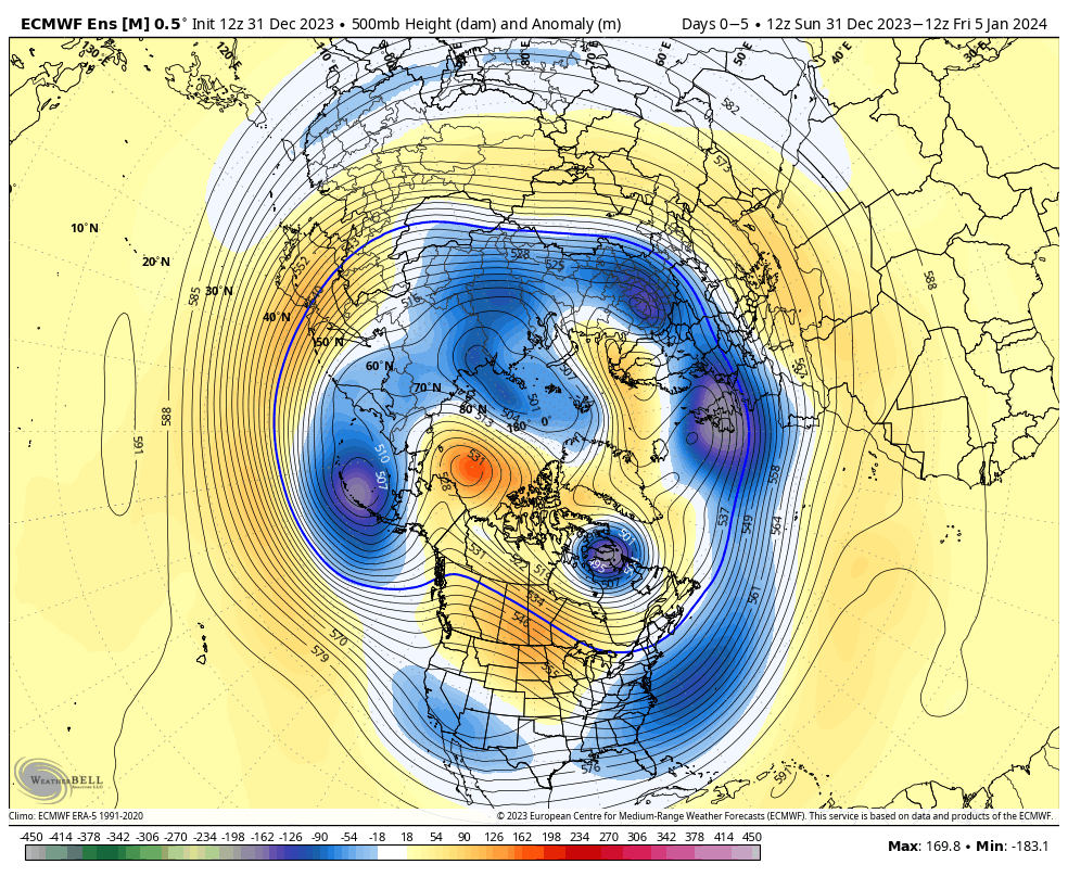
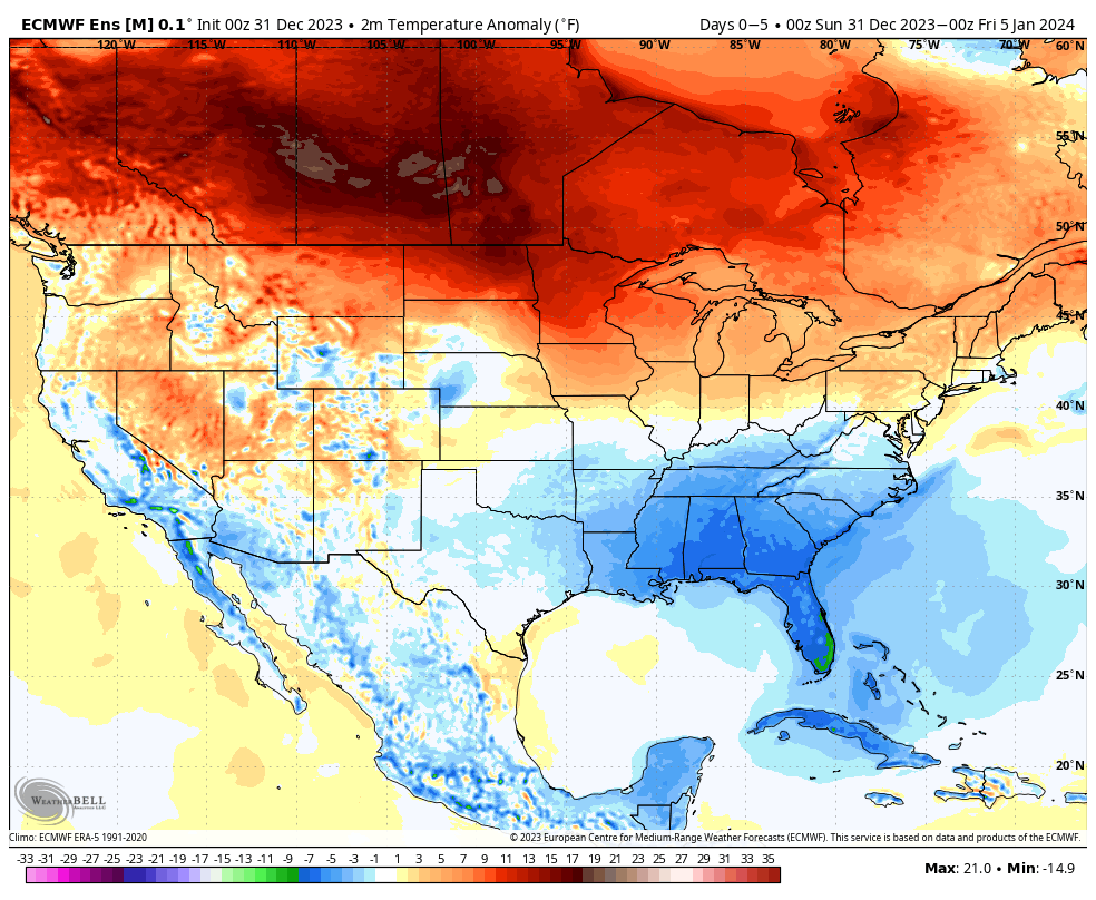
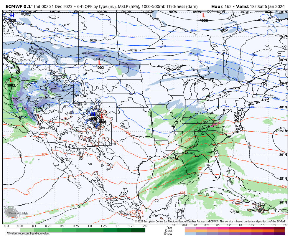
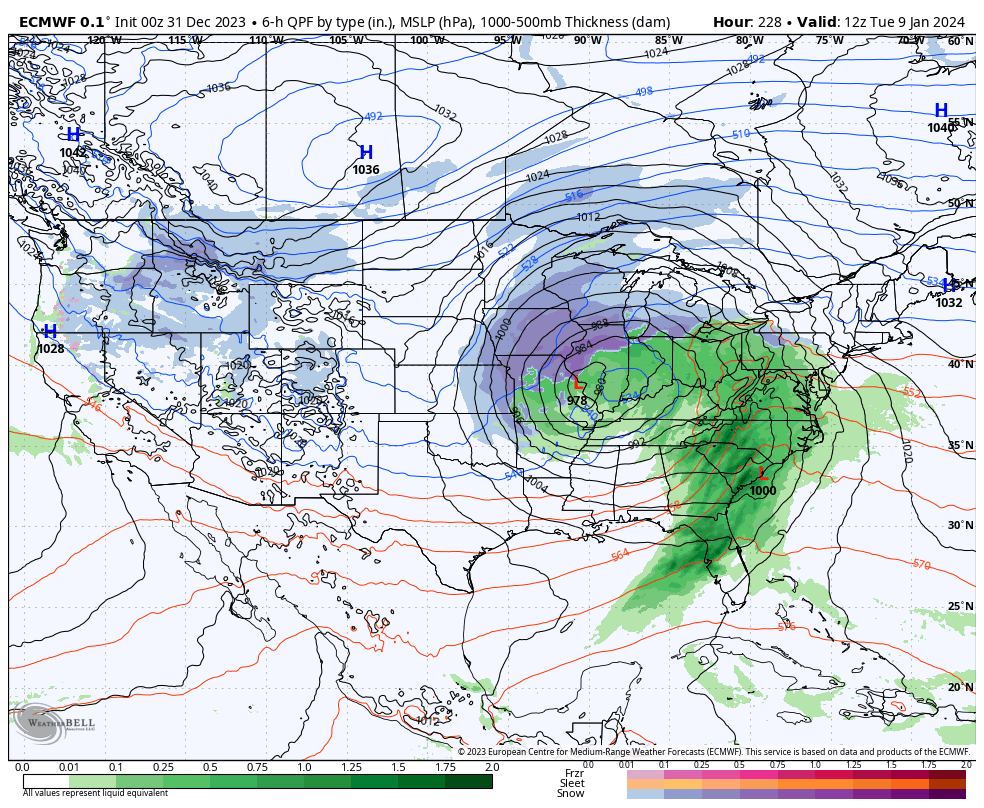
The stage has been set for some time concerning late December and the first week to 10 days of January. There are no changes on our ideas concerning that timeframe. In short, a colder (certainly from where we’ve been as of late, and slightly below the average), and stormy evolution sums up that period.

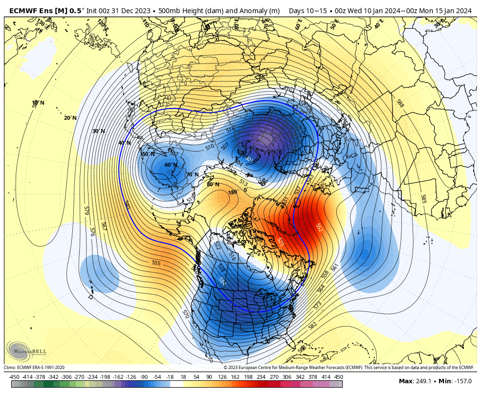
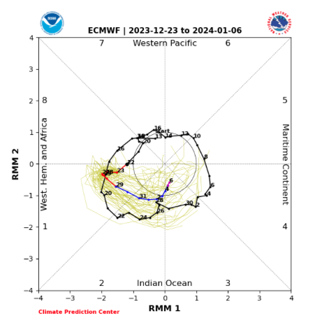
The timeframe now in question has to do with mid and late January, after what sure looks to be a 5-7 day period of moderation. Unlike what we’ve outlined for late December and early January, the second half of January is likely to feature more in the way of a case of “extreme and nothing in between” type pattern. As outlined in Thursday’s long range post, up to this point, modeling has a couple of different takes on the aforementioned period. The American guidance suggests a repeat of well above normal temperatures and a general lack of winter weather looms with an MJO look poised for the classic warm phases.

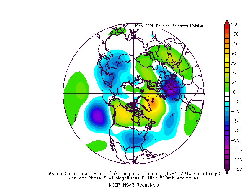
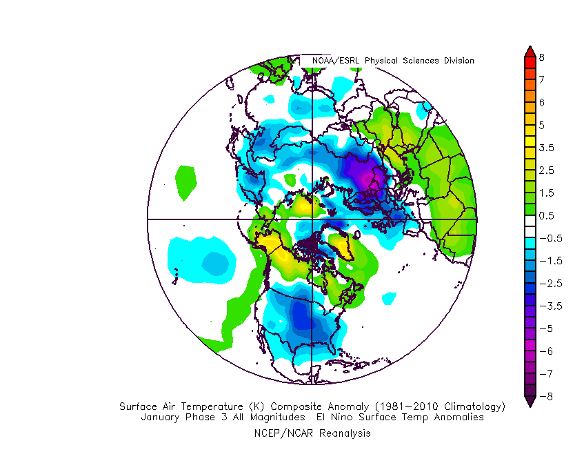
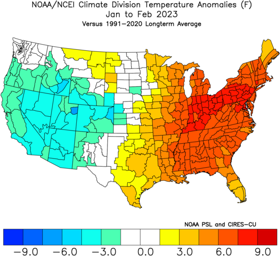
You likely don’t need us to remind you of January and February last year. Indianapolis ran a whopping 8.1° above normal through the first couple months of the year.

The reason? An amplified MJO rolling slowly through the Phases 3, 4, and 5 before getting into the colder phases late February and into March.

Back to present day, the American guidance, though slowly backing off from the aggressive idea from a couple days ago, suggests this is once again on the table. Should that come to fruition, mid January would feature well above normal temperatures yet again.

As the great Lee Corso famously coined, “not so fast, my friend.” The European guidance collapses the MJO into the null, or neural phase, before getting into the warm phases. While a period of moderation still will likely follow the chilly open to January, should the Euro idea be correct (and we suspect it is- more on that below), an eventual recycling through the cold phases would likely ensue late January into early February.

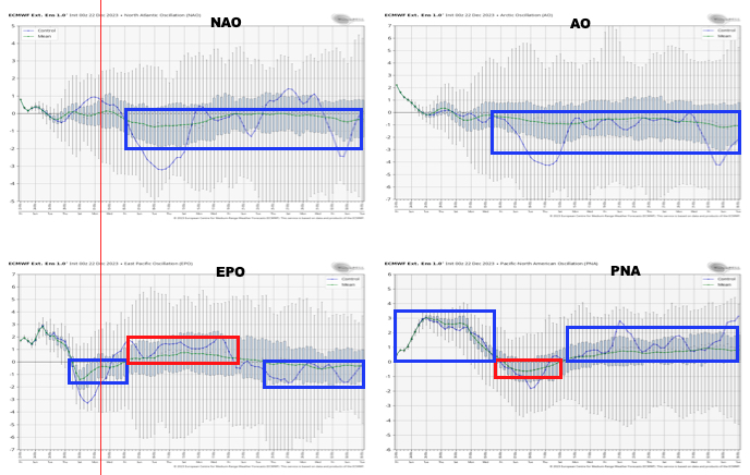
By this point, guidance is also beginning to align on other important pattern drivers. Remember, by mid January, we really start to lean in on what the NAO and AO are doing. That’s certainly not to say we don’t pay attention to the PNA and EPO- just that the AO/ NAO can have greater influence on the regime into early spring. Of course, the MJO remains king.

What’s interesting is that each respective “driver” positions itself in a manner that argues cold should rule during the late January and early February period.

Should that MJO circle back into the traditional cold phases, look out. The window will open for a period of true arctic air getting involved with the pattern given the other pattern drivers above. – Target period would be late January (after Jan. 15th) and into early February.

Given what’s out there for the taking, it’s certainly not a pattern for the faint of heart. Buckle up!

Permanent link to this article: https://indywx.com/a-tale-of-2-potential-extremes-for-late-january-and-an-early-lean/

VIDEO: A Wet Christmas On Deck; MJO From The Past Shows Clues To The Future…

Updated 12.20.23 @ 7:50a Today is the pick of the week, weather-wise, as partly cloudy skies dominate and a moderating trend takes hold with a south to southwesterly breeze. After…

You must be logged in to view this content. Click Here to become a member of IndyWX.com for full access.  Already a member of IndyWx.com All-Access?  Log-in here.

Permanent link to this article: https://indywx.com/video-a-wet-christmas-on-deck-mjo-from-the-past-shows-clues-to-the-future/

VIDEO: Pattern Drivers Align For Late Month/ Early January Evolution; Periods Of Wet Weather Returns For Christmas…

Updated 12.19.23 @ 6:55a “Number busting” cold is greeting us out the door this morning. Heavier cold weather gear will be required today, despite sunshine returning. An unsettled, but milder…

You must be logged in to view this content. Click Here to become a member of IndyWX.com for full access.  Already a member of IndyWx.com All-Access?  Log-in here.

Permanent link to this article: https://indywx.com/video-pattern-drivers-align-for-late-month-early-january-evolution-periods-of-wet-weather-returns-for-christmas/