Category: Arctic Cold

Looking Ahead; Cold Pattern Reloads.

We’ll have your updated 7-Day forecast posted later today.

The latest mid and long range guidance continues to suggest we’re heading into another prolonged period of below normal temperatures.

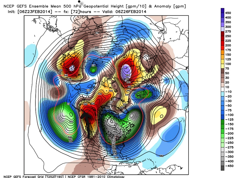
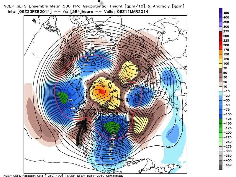
Ensemble data (below) shows ridging in the northeast Pacific, extending into Alaska and this pattern has been one of the big reasons as to why we’ve dealt with so many arctic intrusions this winter.  (The first image is a look at the upper air pattern dated Feb. 26th and the second is dated March 11th).

Ridging in this particular part of the globe often times dislodges the cold air and someone “down stream” has to deal with below normal air.  The recipient of being “down stream” has just so happened to be the upper Mid West into the Ohio Valley and much of the eastern half of the country this winter.  That doesn’t show any signs of changing over the next couple weeks, at least.  It’s possible we could deal with a day or two of milder weather thrown in the mix, but the overwhelming majority of the upcoming couple weeks looks much colder than normal.

GEFS1GEFS2

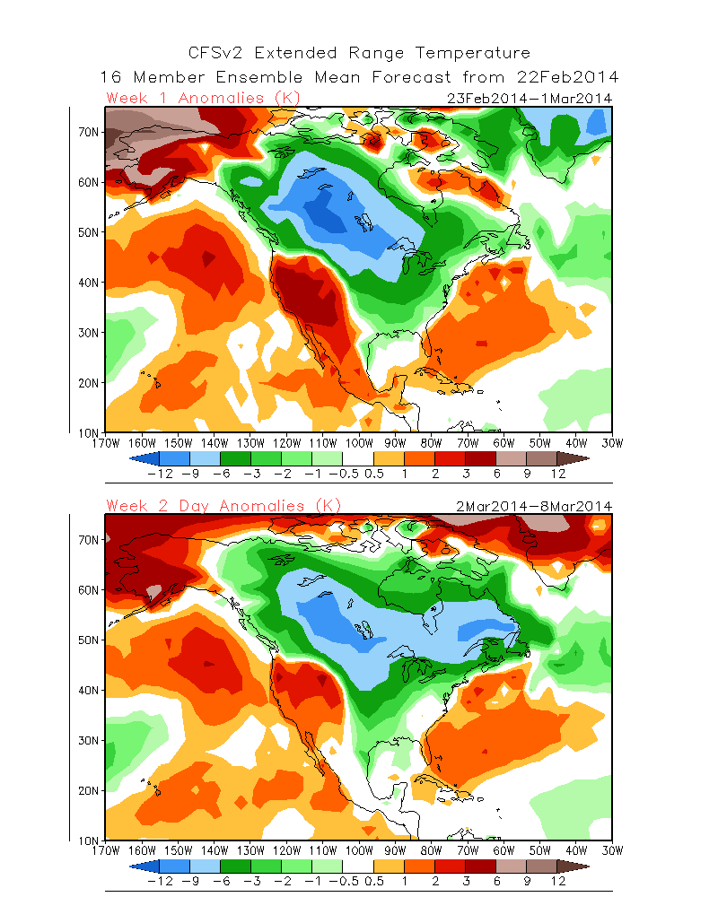
The result is a continuation of much below normal cold in our part of the country.  The following graphics illustrate temperature anomalies (in celsius) centered on 5 days between Feb. 23rd-28th and March 6th-11th.  Below normal temperatures continue.

GEFS3GEFS4


A couple of additional thoughts around the upcoming cold pattern: While we can’t show the images here (license issues), the “secret” European weeklies and ensemble data continues the cold, stormy regime across the east for the better part of the upcoming 30 days, with a couple of brief periods of milder, “calmer” weather.

Finally, the CFSv2 suggests the cold regime continues, as well.  The first image shows upcoming weeks 1 and 2 and the second shows temperature anomalies weeks 3 and 4.  Note the CFSv2 shows southeast ridging developing towards the end of the period, potentially suggesting a big fight goes on between the cold to the north and the budding spring conditions to the south- a stormy suggestion…

CFSv2Wk1:2CFSv2Wk3:4

In closing, it’s important to note that all of the fancy graphics shown above are simply model guidance and it’s up to us, the forecasters, to interpret the data the best way possible to put together the most accurate mid to long range ideas for you, the viewer.  While nothing is a guarantee in this business, it does appear as if chances are quite high that our region deals with another few weeks of colder than normal conditions and potentially active weather ahead.  Stay tuned.

Permanent link to this article: https://indywx.com/looking-ahead-cold-pattern-reloads/

Back To Winter We Go

Fri.

Sat.

Sun.

Mon.

Tue.

Wed.

Thr.

 Status-weather-snow-scattered-day-icon

 Status-weather-clouds-icon

 Status-weather-snow-scattered-day-icon

 Status-weather-snow-scattered-day-icon

 Status-weather-clouds-icon

 Status-weather-clouds-icon

 Status-weather-clouds-icon

31/ 43

31/ 44

26/ 34

18/ 32

19/ 26

8/ 22

7/ 19 

Light

– – –

Light

Light

– – –

– – –

– – –

Forecast Updated 02.21.14 @ 7:30a

Chilly, Windy Close To The Week…After a busy Thursday night that included hail reports, damaging wind gusts, and flooding we’re looking at a calmer, yet blustery and colder close to the work week as low pressure heads north into Canada.  Winds will remain strong and gusty this morning, but begin to “relax” as we head into the afternoon, diminishing slowly through the day.  That said, it’ll remain quite blustery and much cooler than the flirt with spring Thursday.  A couple of snow showers may fly in shallow wrap around moisture this morning.

For now, we think Saturday will remain mostly dry, but a fast moving weather disturbance will scoot by to our north and could result in an increase in cloud cover Saturday afternoon.

Sunday Snow?  That remains the question, but we continue to closely monitor a disturbance that could produce accumulating snow here Sunday afternoon into Monday.  Model data is all over the place and ranges anywhere from a mainly dry day Sunday to a full blown accumulating snow event of a few inches.  It’s worth noting the Canadian is the most bullish on Sunday accumulation potential and we’re leaning more towards that direction as of now, especially when considering the way the Canadian handled the Valentine’s snow event.  Stay tuned.

Big Cold…A major league late season blast of arctic air will blow into town by the middle of next week and result in temperature close to 25-30 degrees below normal.  We’ll monitor the “goings on” late next week as indications points towards a storm brewing.  Early ideas take this mainly south of our immediate region, but we’ll continue to monitor.

Upcoming 7-Day Precipitation Forecast

  • 7-Day Snowfall Forecast:  1-3″
  • 7-Day Rainfall Forecast: 0.00″


images

For weather updates and more “behind the scenes” data on the go, be sure to Follow Us on Twitter @indywx or become a Friend of IndyWx.com on Facebook!

twic

Permanent link to this article: https://indywx.com/back-to-winter-we-go/

Cold Today; Messy Monday Ahead.

Sun.

Mon.

Tue.

Wed.

Thr.

Fri.

Sat.

 Status-weather-clouds-icon

 Status-weather-freezing-rain-icon

 Status-weather-clouds-icon

 images

 Status-weather-storm-night-icon

 Status-weather-clouds-icon

 images

16/ 25

15/ 33

20/ 39

24/ 42

35/ 57

28/ 45

28/ 50 

0.00”

1-3″ (and ice)

0.00”

Trace

0.50″-1.00″

0.00″

0.00”

Forecast Updated 02.16.14 @ 11:15a

Cold Sunday…Fresh off celebrating our snowiest winter on record (surpassed last night at IND at 51.6″ and the Record Event Report can be found here), we’ll enjoy a dry day, but blowing and drifting snow will remain an issue in the open country. A few breaks in the cloud cover can be expected this afternoon on what will otherwise be a rather cloudy day.  Highs will only climb into the lower to middle 20s (well below the average high of 40 and closer to the normal low of 24).  Yes, our cold, snowy winter just keeps on keepin’ on!

Snow And Ice Issues Monday…A storm system will move through the region Monday and deliver a mixture of precipitation types across central Indiana.  The way we see things unfolding as of this forecast update brings a wintry mix of sleet and snow into the city around noon with periods of moderate to even heavy wintry precipitation falling into the mid to late afternoon hours before we begin to see the shield of moisture push northeast.  This will be a “thump and go” type event.

As for precipitation type, this remains a challenge and will require much fine tuning later tonight and through the day tomorrow (another now cast scenario).  We’re thinking mostly snow is the dominant form of precipitation from the northern suburbs of Indianapolis and points north.  Here, 2-3″ of wet snow is possible, polished off with a light glaze of a freezing rain/sleet mixture before precipitation ends.  For the city, itself, we think around 1-2″ of snow is possible with a glaze of freezing rain of around a tenth of an inch. Farther south, to include the southern Indianapolis suburbs, an icy mixture of sleet and freezing rain will be the concern with glaze potential approaching one quarter inch.  Again, we caution this is our best idea at this point and we’ll post some fresh thoughts later this evening.

Needless to say, tomorrow stands to include treacherous driving conditions in and around central Indiana and the National Weather Service will likely issue Winter Weather/ Freezing Rain Advisories later this afternoon to account for the wintry conditions anticipated tomorrow afternoon.

Flooding Concerns On The Rise…With such a deep snowpack across central Indiana, combined with a frozen ground, flooding concerns will be on the rise as early as the middle to latter part of the week.  We think dry and chilly (albeit milder) conditions will be with us Tuesday, but low clouds, fog, and drizzle likely develop by Wednesday as milder air streams north over the snowpack locked in across the region.

By Thursday, our attention turns to the potential of heavy rain and a couple of thunderstorms as a cold front blows through the region.  Early ideas of Thursday rainfall numbers would suggest anywhere from .50-1″ of rain is laid down and when combined with the heavy snow pack and milder air, flooding concerns will certainly be present.  Needless to say, if you live in a flood prone area, please monitor the situation closely later this week.

Winter Blows Back In…As promised, the briefly milder shot of air would be just that- brief.  We continue to monitor data that suggests a colder, more wintry, pattern blows right back into the region to wrap up February.

twic

For weather updates and more “behind the scenes” data on the go, be sure to Follow Us on Twitter @indywx or become a Friend of IndyWx.com on Facebook!

images

Permanent link to this article: https://indywx.com/cold-today-messy-monday-ahead/

Saturday Morning Notes…

* Your full, updated, 7-Day Forecast will be published later tonight. 1.) In the long range, credit the Canadian model for being spot on with yesterday’s snow storm.  It was…

You must be logged in to view this content. Click Here to become a member of IndyWX.com for full access.  Already a member of IndyWx.com All-Access?  Log-in here.

Permanent link to this article: https://indywx.com/saturday-morning-notes/

Valentine’s Day Snow

Fri.

Sat.

Sun.

Mon.

Tue.

Wed.

Thr.

 Status-weather-snow-scattered-day-icon

 Status-weather-snow-scattered-day-icon

 Status-weather-clouds-icon

 Status-weather-showers-scattered-icon

 Status-weather-clouds-icon

 Status-weather-clouds-icon

 Status-weather-storm-night-icon

19/ 27

6/ 26

14/ 30

23/ 40

22/ 43

32/ 50

38/ 62 

2-5″

1″

0.00”

0.40″

0.00″

0.00″

0.50″

Forecast Updated 02.14.14 @ 11:00a

Accumulating Valentine’s Day Snow…The Canadian led the charge and other modeling has followed suit.  The region will deal with accumulating snow Valentines Day as low pressure moves southeast out of Missouri into the Tennessee Valley.  We think snow will fall at a good clip, periodically heavy, and begin around mid morning around the city.  In fact, a strip of 2-5″ of snow is likely to be laid down between Indianapolis and Louisville later today.  Latest radar trends from upstream and banding features suggest snowfall amounts may reach 6″ along the I-70 corridor. Needless to say, if you have travel plans this afternoon plan for snow covered roads and slick travel.

A fresh shot of arctic air will drill south into the region tonight and result in Saturday “wake up” temperatures in the single digits with a biting northwest wind.

Another Fast Moving Clipper…After a mostly dry Saturday, we forecast light snow to build back into the region Saturday night into early Sunday.  This will only be a light snow event and most amounts will be in the dusting to 1″ category.  The sun should quickly return Sunday afternoon, though it’ll remain colder than normal.

Foggy Start To The Week…As a southerly air flow transports milder air north and over the snow pack across central Indiana fog will develop.  It’s possible some freezing drizzle is dealt with Monday morning before temperatures rise above freezing.  Prepare for a downright gloomy start to the work week.  A cold front will push through the region Monday evening and lead to a period of showers, potentially transitioning to light snow or a light wintry mix Monday night as cold air sweeps back in.

A Spring Tease…A spring tease will have many Hoosiers wanting to break out the shorts by the mid week period.  In fact, highs will zoom into the 60s Thursday, courtesy of a strong and gusty southwest breeze.  The downside?  A line of showers and gusty thunderstorms later in the day.  While we still have a week to monitor this situation, the possibility is there for a few storms to reach severe levels across the Ohio Valley region.  Stay tuned as we monitor this developing weather situation.

Looking longer term, we anticipate the briefly milder spring “tease” to be just that.  Signals are increasingly favorable for a prolonged period of cold, wintry conditions building back into the region as we put a wrap on February and head into March.

imagesFor weather updates and more “behind the scenes” data on the go, be sure to Follow Us on Twitter @indywx or become a Friend of IndyWx.com on Facebook!

twic

Permanent link to this article: https://indywx.com/valentines-day-snow/