Category: Arctic Cold

Dangerous Cold.

The “big dig” may have to wait a couple of days as brutal temperatures and wind chills will make for downright dangerous conditions to be outdoors for any length of time.  Coming off the city’s second snowiest day in history (11.1″), we now have to contend with dangerous cold. This is the type of cold that can turn deadly should you be outdoors for any length of time.  Take it seriously and remain indoors hunkered down if at all possible.

Before we look at the cold, here’s a snap shot of storm snowfall totals from our winter storm.  “Historic,” “Severe,” “Memorable” are all words that come to mind when discussing this storm.  Widespread 12″ + totals have been reported across central Indiana, and drifts are approaching 7 feet in spots.

snowfall_7am

Temperatures today will only reach the 10-12 BELOW zero mark, coupled with wind chills that dip below 40 BELOW zero at times through the day.  With the wind, blowing and drifting snow will remain a concern.

Hi


plotter

Permanent link to this article: https://indywx.com/dangerous-cold/

“Memorable” Winter Storm Just Beginning…

Our severe winter storm is just in the beginning stages and we’ll note rapidly deteriorating conditions moving into the afternoon and on into the night.  Please don’t take this storm lightly. Conditions will become life threatening this afternoon into Monday and don’t be surprised if Blizzard Warnings are issued today.

 Here are some quick bullet points you need to know:

  • 2″ per hour snow rates develop this afternoon
  • The pressure “gradient” tightens tonight leading to Blizzard conditions from late afternoon into Monday morning
  • 9-12″ of snow from Indy and points north, 5-9″ south-central Indiana
  • Drifts grow to 3-5 feet overnight into Monday (local drifts to 6 feet likely for the open country)
  • Monday’s high: 12 BELOW zero (not a typo)
  • Wind Chills: 40-50 BELOW zero by Monday morning

Latest high-resolution model data in house puts down widespread snow total of one foot, including Indianapolis, Zionsville, Noblesville, Avon, Anderson just to name a few…

hires_snow_acc_indy_11

Please be sure to hunker down today and remain inside if at all possible.  Conditions will become life threatening upon venturing out of your home tonight and Monday.

Permanent link to this article: https://indywx.com/memorable-winter-storm-just-beginning/

Cold Is Something To Behold!

With all of the talk about the snow and near-blizzard conditions Sunday (rightfully so), we wanted to make sure we discussed the pending arctic outbreak and record-smashing temperatures ahead early next week.

(As a side note, our going snowfall accumulation ideas remain unchanged with a band of 9-12″ of snow from Indianapolis and points north with less amounts south of Indy where mixing issues will keep accumulations in the 5-9″ range).

As our winter storm moves northeast into the Great Lakes Sunday night, it’ll help slug a huge piece of arctic air south to the likes not seen around these parts since 1994.  We’re talking about dangerous, life threatening, cold Sunday night through Wednesday morning.  With a deep snow pack on the ground left behind by our memorable winter storm, the stage will be set for actual temperatures to most likely drop even lower than guidance currently suggests.

We think actual air temperatures fall below zero as early as 12a-3a Monday, per latest guidance.  (Wind chill values will fall below zero shortly after dark Sunday).

hires_t2m_indy_34

Let’s take a look at high temperatures Monday.  Frigid and dangerous temperature conditions continue into mid week…

Daytime Highs Monday will range from 7 to 12 BELOW zero (that’s not a typo).

hires_t2m_indy_46

Additionally, wind chill values will plummet to levels that can quickly lead to frost bite of any exposed skin.  We think wind chill values range as low as 50 degrees below zero Monday.  At 30 degrees below zero, exposed skin can freeze within 30 minutes.  At 40 degrees below zero, exposed skin can freeze within 10 minutes, and at 50 degrees below zero, exposed skin can freeze in under 5 minutes.  Here’s a look at forecast wind chill values:

plotter

Needless to say, please remain indoors and hunker down the next couple days if at all possible.  Weather conditions will be downright dangerous to be outdoors and you risk putting yourself in harms way, as well as first responders, should you venture out of your home.  Getting stuck in a snow bank in any sort of weather conditions is dangerous, but when you factor in this type of cold, major problems can, and will, quickly develop.

Permanent link to this article: https://indywx.com/cold-is-something-to-behold/

Serious Winter Storm Takes Aim On Indiana

We awake this morning to most of the data very consistent with what we’ve been passing along to you over the past few days…a very serious winter storm is taking aim on Indiana and will result in a combination of significant weather events that ultimately may end up being something we’ll remember for quite some time…

Quick Bullet Points:

  • Snow develops early Saturday morning
  • Heaviest snow falls between 10a-5p
  • Wind increases through the day Sunday and gusts in excess of 30 MPH leading to white outs and severe blowing and drifting
  • Temperatures crash to 10-14 below zero Monday morning with wind chill values of 40 to 50 below zero.
  • Widespread snowfall of 5-9″ is likely across central Indiana, with a heavier band of 9-12″ including Indianapolis and running along and just north of the I-70 corridor on the south side north to include Vermillion to Adams counties on the north side.

This is a hazardous and severe winter weather event that will likely lead to road closures from the heavy snow and wind, as well as extremely dangerous conditions to spend anytime outdoors Sunday into early next week due to the cold.  The bitter wind chills will be capable of frostbite in less than 30 minutes to any exposed skin.

Latest model data shows consistency in precipitation amounts, or QPF. We’re showing you the GFS, Canadian, and European models below.  Please note that the numbers and maps below don’t show snowfall amounts, but show precipitation totals.  Bring in a 12-15:1 snowfall ratio with these numbers and you get the snowfall discussed above.  We’re leaning heavily on a Canadian/ European model blend as the GFS has been more erratic.

gfs_total_precip_east_9cmc_total_precip_east_10ecmwf_tprecip_indy_10


Much more later this evening!

Permanent link to this article: https://indywx.com/serious-winter-storm-takes-aim-on-indiana/

Rare And Potentially Crippling Winter Storm Brewing…

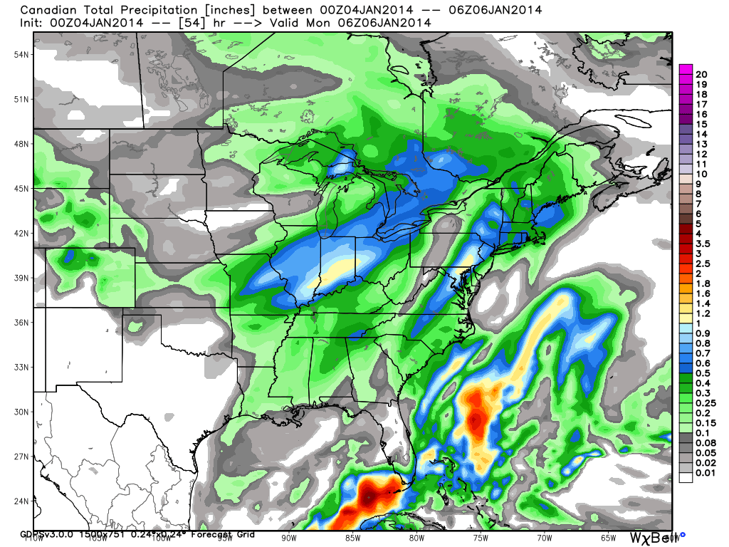
Fresh on the heels of a significant winter storm that impacted central Indiana Wednesday night-Thursday, we’re eyeing our next winter storm and, quite frankly, it could be a memorable one.

We continue to keep a close eye on the pending winter storm Sunday and remain impressed with what we see.  A severe winter storm is brewing and may require blizzard watches and warnings before all is said and done as a combination of heavy snow, strong winds, and severe blowing and drifting promises to make travel difficult, if not impossible, for some areas Sunday.

Setting the stage:

A powerful arctic boundary will drift south towards Indiana Saturday night and Sunday morning.  As this takes place, low pressure will track off the lee of the Rockies and move east, northeast.  Model data continues to suggest this area of low pressure taps into some Gulf of Mexico moisture and really begins to deepen (strengthen) as it tracks into the central/ eastern Ohio Valley Sunday.  To the northwest of the low’s track, a deep blanket of fresh snow will fall.  As the winter storm departs, the coldest air since 1994 will pour into the region on a gusty northwest wind.  Temperatures will reach record territory, and downright dangerous levels, by Monday and Tuesday.

Last night we mentioned a couple of things going “for” and “against” a major winter storm here in central Indiana.  While there’s no doubt going to be a sharp “cut off” of heavy snow with this storm, this “cut off zone” is most likely well north and west of central Indiana.  Additionally, the impressive thermal gradient between the brutal arctic air mass to the north and the warmer air (relatively speaking) to the south and east will only add fuel to a deepening storm moving northeast into the Ohio Valley.  Finally, with arctic air pouring into the region, the “fluff effect” will be in full-go mode, meaning the northwest flank of the heavy precipitation is likely to have snow ratios of 15:1 as compared to the “normal” 10:1 ratio.  This will be very important to watch as the system develops and will most likely be the spot (far too early to pinpoint at this juncture) where snowfall amounts in excess of one foot will fall.

All of our medium range model data is in agreement on central Indiana receiving quite the blow from Old Man Winter Sunday.  Here’s a look at the latest GFS, European, and Canadian forecast models, valid Sunday afternoon:

GFS1EC1CMC1


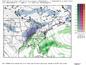
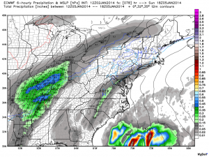
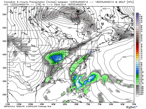
As you can see, there’s excellent agreement and this leads to a rather high confidence idea on a high-impact and rather rare severe winter storm set to impact Indiana.  Can we tell you with certainty exactly where the 12″+ band of snow will lie across the state?  Not at this time.  That said, we suggest preparing now for a rare and potentially crippling winter storm Sunday.  The combination of heavy snow, strong winds, historic cold, and severe blowing and drifting will make for an extremely dangerous situation Sunday, continuing into early next week.  Temperatures by Tuesday morning will approach 20 degrees below zero, with wind chill values plummeting to 40-50 degrees below zero Monday into Tuesday…

Permanent link to this article: https://indywx.com/rare-and-potentially-crippling-winter-storm-brewing/