Category: Arctic Cold
 Spring Fever This Weekend…Lots of sunshine and enough of a southwesterly air flow will help boost temperatures to around the 50 degree mark this afternoon from IND and points south (even some mid to upper 50s possible far down state). Farther north, the deeper snowpack will limit warming and instead keep highs in the upper 30s to near 40 across the northern third of the state.
A cold front will blow through the region Sunday evening with some light shower activity and colder air moving in Sunday night that may lead to a few flurries/ light snow showers Monday morning. Another fast-moving weather disturbance will blow through Wednesday with a light shower and then we’ll welcome winter back into the region with authority. Much colder air and snow showers return for the end of the week.
Looking ahead, mid and late February appears to have plenty of wintry “fun and games” in store for the region. Winter’s far from finished….
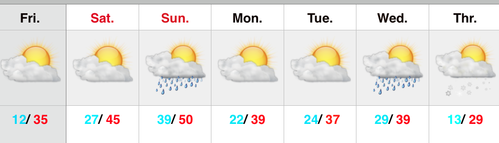
Upcoming 7-Day Precipitation Forecast:
- 7-Day Rainfall Forecast: 0.20″
- 7-Day Snowfall Forecast: Dusting – 1″
Permanent link to this article: https://indywx.com/nice-saturday-but-winters-far-from-finished/
 Spring Fever Anyone?! Hearing lots of rumbles of folks craving spring, as is usually the case around these parts come early February. We still have more winter to go, but this weekend may lead to a surge in spring fever as temperatures moderate. We may have to deal with more clouds than we’d like, but temperatures will warm to well above normal levels- especially Sunday. We’ll introduce a couple of showers into the mix for the second half of the weekend, but these won’t be a big deal.
Slightly colder air moves in early next week, but it’s really not until after a weak disturbance passes Wednesday that the true arctic plunge will take place.
Upcoming 7-Day Precipitation Forecast:
- 7-Day Rainfall Forecast: 0.10″ – 0.20″
- 7-Day Snowfall Forecast: Trace
Permanent link to this article: https://indywx.com/moderating-weekend-temperatures/
After anywhere from 1″ to 3″ of snow fell on central Indiana Wednesday evening, we’re now left to deal with bitterly cold conditions. Many north-central Indiana neighborhoods are below zero this morning. Places such as Indianapolis are in the single digits and northern ‘burbs have been flirting with zero.
Today will feature lots of sunshine, but very cold conditions. Highs will struggle to reach the 20 degree mark.
 Much more later today, including your updated 7-day! Have a fantastic Thursday!
Permanent link to this article: https://indywx.com/bitter-day/
We’re still on track for accumulating snow arriving into central Indiana this afternoon and continuing through the evening. Expect the rush hour to be impacted. Snow will overspread central Indiana…
You must be logged in to view this content. Click Here to become a member of IndyWX.com for full access. Already a member of IndyWx.com All-Access? Log-in here.
Permanent link to this article: https://indywx.com/snowy-evening-ahead/
Quick video update this evening talking about the snow, wind, and bitterly cold air that blows into town Wednesday. Plan on a nasty evening commute tomorrow, friends.
You must be logged in to view this content. Click Here to become a member of IndyWX.com for full access. Already a member of IndyWx.com All-Access? Log-in here.
Permanent link to this article: https://indywx.com/video-update-on-wednesdays-snow/
