Winter Storm Video Brief
You must be logged in to view this content. Click Here to become a member of IndyWX.com for full access. Already a member of IndyWx.com All-Access? Log-in here.
You must be logged in to view this content. Click Here to become a member of IndyWX.com for full access. Already a member of IndyWx.com All-Access? Log-in here.
Good morning and happy Friday, friends! Boy, Old Man Winter is really beginning to turn some minds around from thinking this was an easy winter to one that’s quite impressive, especially from a cold standpoint. By the way, there’s MUCH more from where this came from! Essentially we remain on “lock down” for more brutally cold and wintry conditions for the upcoming 7-10 day period. More on that later.
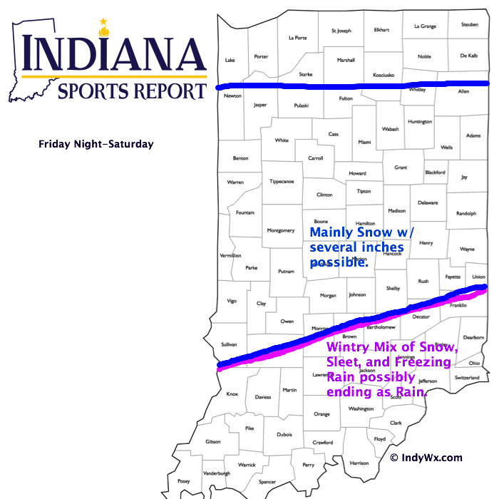
Here’s a look at our initial snowfall forecast map for tonight and Saturday:
 Forecast radar shows heavy wet snow encompassing central Indiana Saturday morning:
 Bullet point highlights you need to know:
Here’s our latest thinking in regards to Friday night and Saturday.
 Highlights:
 Heavy Cold Weather Gear Needed…It’s a frigid morning across central Indiana with all reporting sites well below zero. Despite the sunshine today, we’ll only “warm” into the middle single digits- smashing the former record cold maximum of 12 degrees. Amazing stuff! Wind chills will remain below zero and downright dangerous.
Eyes shift to a wintry weather maker this weekend and overnight computer guidance has begun to catch onto a much more realistic suppressed, colder solution, as opposed to the warmer and more aggressive storm into the Ohio Valley. We still have time to watch for additional changes, but for now we think light snow overspreads central Indiana Friday evening, before a bit heavier precipitation moves in late Friday night and Saturday morning. The “2nd round” of precipitation will likely consist of most of the ice/snow accumulation, including mostly snow across north-central Indiana, a messy mix of sleet and freezing rain across the heart of central Indiana, and a cold rain downstate. Caution though that this is still preliminary thinking and certainly subject to change. An early guesstimate on central Indiana snowfall potential with this system would be for a light to borderline moderate event- 2″ to 4″ type deal.
The Arctic Express quickly gains momentum yet again Sunday night and will lead to another frigid week next week. This pattern is getting to be unbelievable from both the sustained cold, but the extreme nature of the cold, as well. Put this into perspective, only three days of the above forecast period feature high temperatures close to, or slightly warmer, than our average low.
Upcoming 7-Day Precipitation Forecast:
You must be logged in to view this content. Click Here to become a member of IndyWX.com for full access. Already a member of IndyWx.com All-Access? Log-in here.